After my first experience getting hacked, I am back up. Thanks to my developer, Jamon at Clearsightstudio.com, who also installed a new security plugin. Shouldn’t happen again.
Archive for February, 2013
Back in the Saddle Again
Thursday, February 28th, 2013Tropical SSTs Since 1998: Latest Climate Models Warm 3x Too fast
Thursday, February 21st, 2013Following up on yesterday’s post, I’d like to address the more general question of tropical sea surface temperatures since 1998. Why haven’t they warmed? Of course, much has been made by some people about the fact that even global average temperatures have not warmed significantly since the 1997/98 El Nino event.
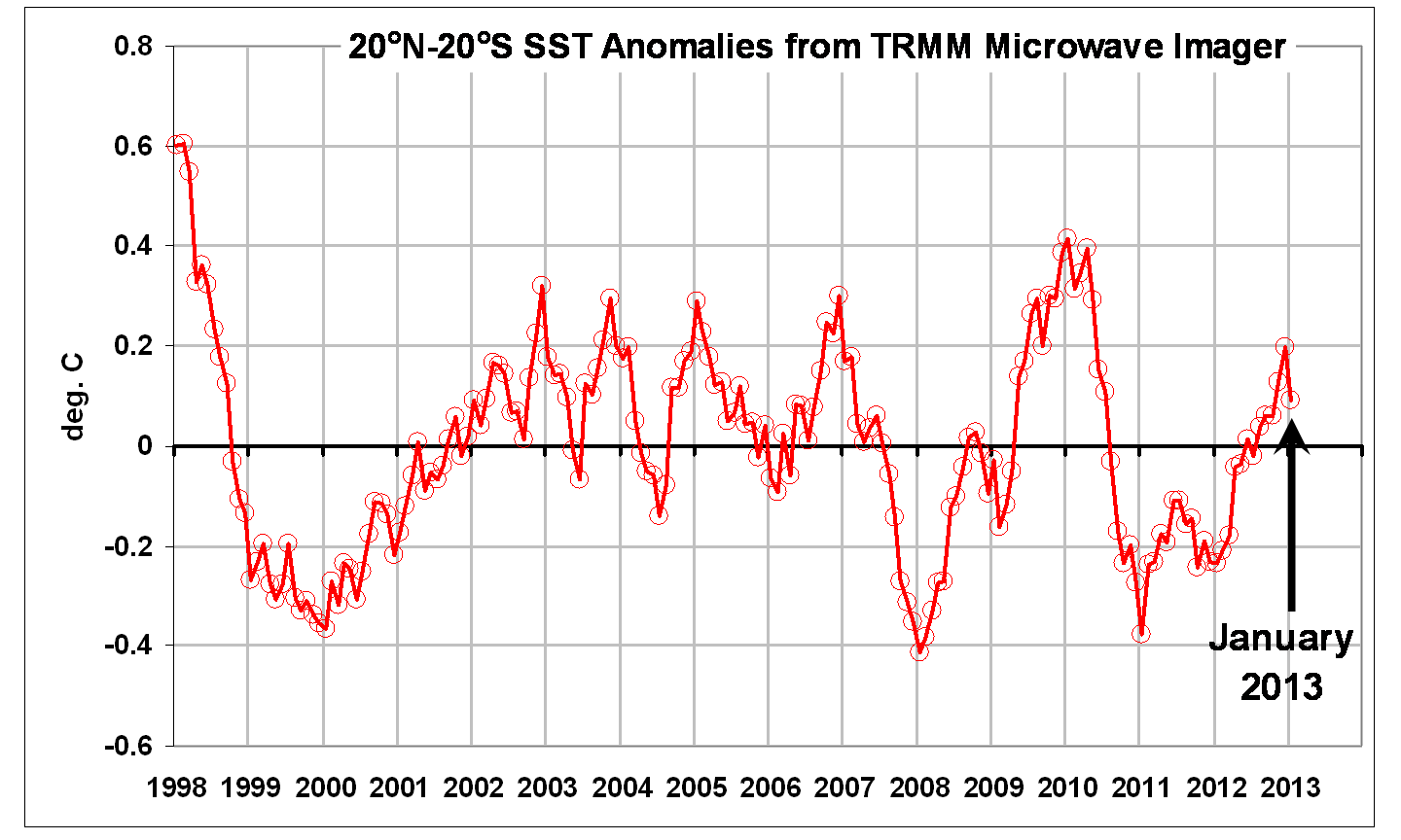
Using the Tropical Rain Measuring Mission (TRMM) Microwave Imager (TMI) SSTs available from Remote Sensing Systems (all 15 GB worth), here I will statistically adjust tropical SSTs for El Nino and La Nina activity, and see how the resulting trend since 1998 compares to the latest crop of IPCC CMIP5 model runs. We will restrict the analysis to 20oN to 20oS latitude band, which is the usual latitudinal definition of “tropical”.
The resulting TRMM TMI SST anomalies since January 1998 through last month look like this:
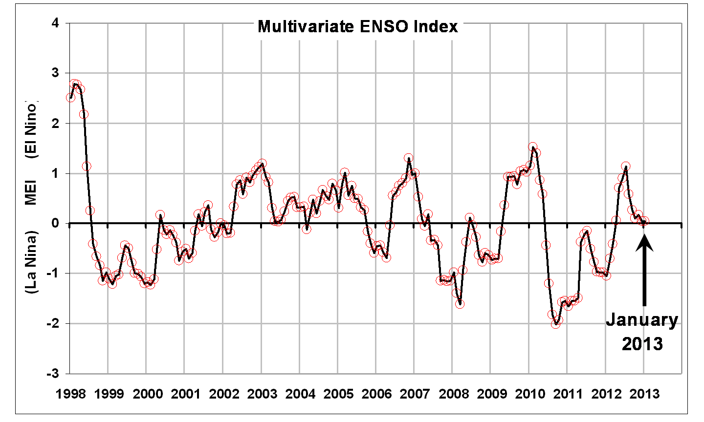
The up and down variations are clearly related to El Nino and La Nina activity, as evidenced by this plot of the Multivariate ENSO Index (MEI):
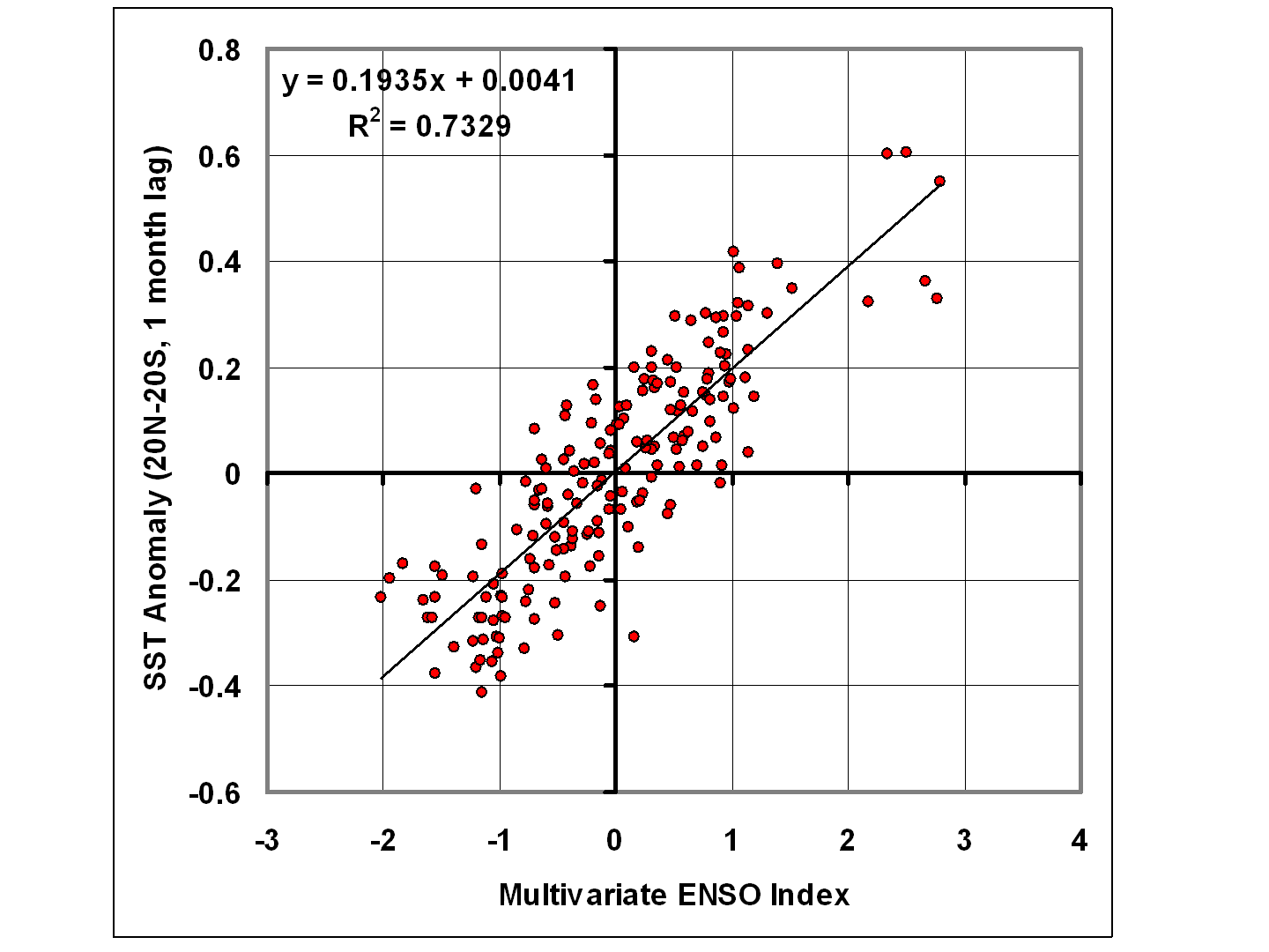
We can then plot these SST and MEI data against each other…
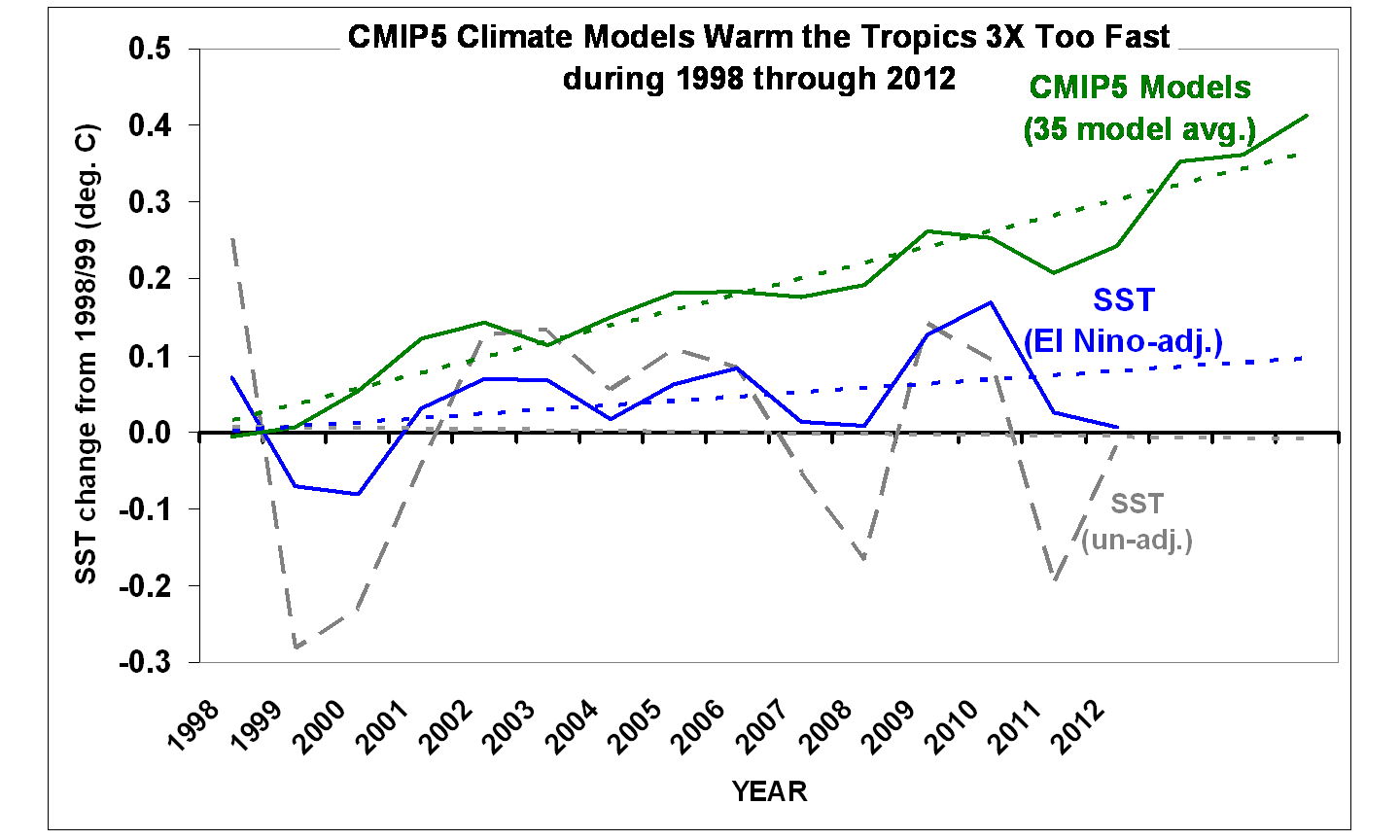
…and use this statistical relationship to estimate SST from MEI, and then subtract that from the original SST data to get an estimate (however crude) of how the SSTs might have behaved without the presence of El Nino and La Nina activity (the blue line):
Note that I have now averaged the monthly data to yearly, and this last plot also shows an average of 35 CMIP5 climate models SSTs during 1998-2012 for the same (tropical) latitude band, courtesy of John Christy and the KNMI climate explorer website. Also note I have plotted all three time series as departures from their respective 1998/99 2-year average.
The decadal linear temperature trends are:
un-adj. SST: = -0.010 C/decade
MEI-adj. SST: +0.056 C/decade
CMIP5 SST: +0.172 C/decade
So, even after adjusting for El Nino and La Nina activity, the last 15 years in the tropics have seen (adjusted) warming at only 1/3 the rate which the CMIP5 models create when they are forced with anthropogenic greenhouse gases.
Now, one might object that you really can’t adjust SSTs by subtracting out an ENSO component. OK, then, don’t adjust them. Since the observed SST warming without adjustments is essentially zero, then the models warm infinitely faster than the observations. There. 😉
Why Have the Models Warmed Too Fast?
My personal opinion is that the models have cloud feedbacks (and maybe other feedbacks) wrong, and that the real climate system is simply not as sensitive to increasing CO2 as the modelers have programmed the models to be.
But there are other possibilities, all theoretical:
1) Ocean mixing: a recent increase in ocean vertical mixing would cause the surface to warm more slowly than expected, and the cold, deep ocean to very slowly warm. But it is debatable whether the ARGO float deep-ocean temperature data are sufficiently accurate to monitor deep ocean warming to the levels we are talking about (hundredths of a degree).
2) Increasing atmospheric aerosols: This has been the modelers’ traditional favorite fudge factor to make climate models keep from warming at an unrealistic rate…a manmade aerosol cooling effect “must be” cancelling out the manmade CO2 warming effect. Possible? I suppose. But blaming a LACK of warming on humans seems a little bizarre. The simpler explanation is feedbacks: the climate system simply doesn’t care that much if we put aerosols *OR* CO2 in the atmosphere.
3) Increasing CO2 doesn’t cause a radiative warming influence (radiative forcing) of the surface and lower atmosphere.
I’m only including that last one because, in science, just about anything is possible. But my current opinion is that the science on radiative forcing by increasing CO2 is pretty sound. The big uncertainty is how the system responds (feedbacks).
Apparent Reason for January 2013 Tropospheric Warmth
Wednesday, February 20th, 2013NASA’s Tropical Rain Measuring Mission (TRMM) has been, in my opinion, a huge success. It has been operating for over 15 years now, which makes me feel pretty old since I was involved in the early design of the TRMM Microwave Imager (TMI) that flies on TRMM. I campaigned for it to carry 10.7 GHz channels which would allow sensitivity to heavy rain, as well as all-weather sea surface temperatures. TRMM also carries the first spaceborne precipitation radar, which was built by Japan.
Given my recent post about the strong warming of global tropospheric temperatures in January 2013, I thought I would follow up with a comparison between tropical SSTs, tropospheric temperature, rainfall, etc. in January. The data support my previous claim: the anomalous tropospheric warmth was the result of a temporary increase in convective heat transport from the surface to the atmosphere, as evidenced by cooling SSTs, and well-above average precipitation. (Bob Tisdale has also addressed the SST issue in January, from a different set of [IR-sensing] satellites).
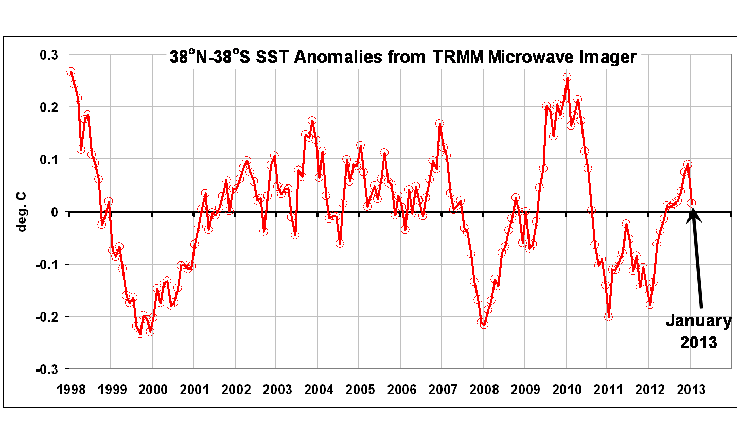
The following plot shows TMI monthly SST anomalies averaged over 38oN to 38oS since January 1998, the first full month of operations, and the maximum latitude range which TRMM has continuously covered over its 15+year lifetime:
Note that TRMM started operations in the middle of the historic 1997/98 El Nino event, so the beginning of the time series is very warm.
Also note the dip in SSTs in January, 2013. This was the same time as the AMSU instruments recorded an anomalously warm January.
The next plot shows the monthly rainfall anomalies for the same period of time, and it is clear that rainfall activity (and thus latent heating of the troposphere) was well above average in January:
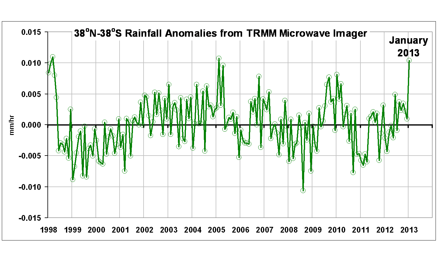
I have other plots (cloud water, surface wind speed), but the above two plots tell the crux of the story: Above-average moist convective heat transport from the ocean surface to the atmosphere appears to have led to sea surface cooling, and tropospheric warming, in January 2013.
Exploding Russian Meteor: An Asteroid Fragment?
Friday, February 15th, 2013UPDATE (12:18 CST 12/15/2013): A little more than 12 hours after the Russian meteor event occurred, it now appears to be the consensus of opinion that the meteor had nothing to do with the asteroid making its close approach to the Earth today. The two objects appear to have been on very different trajectories, and so it is difficult to see how they could have been sharing the same orbit around the sun.
The meteor which exploded over the Urals of Russia on 15 February 2013 entered the Earth’s atmosphere within hours of the closest approach ever recorded of an asteroid to the Earth, named 2012 DA14.
The above video of the event is quite spectacular, with a number of dash cams capturing the exploding meteor’s trail. The meteor was estimated by the Russian Academy of Sciences to be about 10 tons, which caused buildings to be damaged from the shock wave, and hundreds of injuries from flying glass.
This is the most spectacular bolide (large, bright meteor) event I can remember in my lifetime. The various videos suggest that it might have become brighter than the midday summer sun, although it is difficult to tell because the sun was very low in the sky (in the middle of the Russian winter) when the event happened.
While I am not an expert, I suspect that this was a fragment of asteroid 2012 DA14 passing closest to the Earth today (Feb. 15). This is simply too much of a coincidence. I also expect that this event will lead to renewed calls for government programs to deal with the potential threat of an asteroid collision with the Earth, a threat which space experts have been saying is very real. It’s only a matter of time before an asteroid large enough to cause substantial damage will reach the Earth. I’d be interested to hear the opinions of others on this.
By way of historical perspective, the 1908 Tunguska Event involved what is believed to be an exploding meteor or fragment of a comet, which leveled over 800 sq. miles of forest in rural Russia. The size of the meteor or cometary fragment has been estimated to be around 100 m in diameter, which is somewhat larger than the 2012 DA14 asteroid which makes its closest approach to Earth today, 15 February 2013.
Time Out for Some Time Lapse
Wednesday, February 6th, 2013OK, boys and girls, time to take a break from bickering over warming trends and the greenhouse effect. 🙂
Let’s take in some of Nature’s beauty. My new hobby is time lapse photography, and here are 4 very short video segments I’ve put together for your enjoyment (sorry, no music to go with them).
For those not familiar with the technique, you can plug a controller into a digital SLR camera on a tripod and take many photos in succession at whatever time interval and exposure settings you want, do some (optional) “high dynamic range” (HDR) enhancement in post-processing, and then render the resulting photos as a video file, which I do in Photoshop.
I’m currently partial to the night sky as a subject, since a good DSLR camera with a fast lens can see more stars and satellites passing over than the unaided eye.
The first video I took last night from a very dark location near Hytop, Alabama (be sure to (1) click on the HD icon to toggle on the high def version, and (2) Full Screen icon next to the “HD” marker after you start the video):
The second video I did a few days ago at Little River Falls, near Ft. Payne, Alabama:
The third video is from my backyard at night, of stars, the moon, Jupiter, and clouds moving past the 1,000 ft tall TV tower we live next to:
The final video was made during our wedding anniversary visit to the Grand Canyon in late November, 2012, and shows moonrise over the Canyon:
The cameras and lenses used for each, as well as the settings, are provided on my Vimeo.com page.
Decreased Surface Wind as a Contributor to Warming
Tuesday, February 5th, 2013I recently discussed the possibility that waste heat from our energy use could be contributing to the observed increase in surface air temperatures, since it potentially rivals the size of the radiative forcing expected from increasing CO2, at least where people live (and put thermometers).
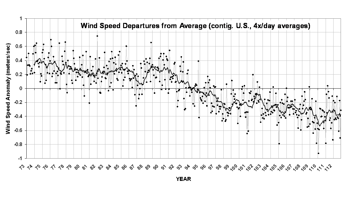
Now I�d like to discuss another possibility, related to something which I�ve noted in the surface weather data over the U.S.: a decrease in average surface wind speed. Over the last 40 years, there has been an observed decrease in near-surface wind speeds of about 0.7 meters per second, which is about 1.5 mph, which is shown in the following plot based upon my analysis of raw hourly ISH data downloaded from NCDC (dots are monthly, solid line is trailing 12-month average; click for large version):
Now, there are 3 basic ways in which land surface temperatures can warm: (1) an increase in absorbed sunlight; (2) a decrease in the rate at which the surface loses infrared (IR) energy, and (3) a decrease in convective heat loss from the surface.
That convective heat loss is made up of both dry and moist convective air currents. For example, dry convection would dominate over the desert; moist convection dominates over the ocean. Together, it is estimated that surface convective heat loss over the Earth averages around 100 Watts per sq. meter….much higher in the tropics, lower toward the poles.
Now, it is well known that convective heat loss is roughly proportional to surface wind speed. A wind decrease of 1.5 mph since the 1970s would represent about a 10% reduction in convective heat loss, which is about 10 W/m2 (all back-of-the-envelope, mind you, taking into account that there is still convective heat loss even when the wind goes to zero on a sunny day�it�s complicated).
Now, the 10 W/m2 is about 10 times larger than the estimate remaining radiative imbalance from increasing CO2. In other words, in some sense, it�s ten times easier to blame increasing U.S. temperatures on decreasing wind speed than on increasing CO2.
Of course, there are a number of caveats, not the least of which, Is the observed decrease in wind speed real?
Globally, more frequent El Nino�s in recent decades also decrease wind speeds over the ocean, which leads to a reduction in convective heat transport. But, the higher ocean surface temperatures (primarily from reduced upwelling of cold water) tend to counteract this by evaporating more water into the lower atmosphere, which can fuel stronger convection. So, there are competing influences which make the problem more difficult to analyze over the ocean.
But all other things being equal, a decrease in wind speed leads to decreased convective heat loss, which then leads to higher higher surface temperatures.
So, what then limits the value of those higher surface temperatures? Well, at 25 deg. C, an increase of 1 deg. C leads to an increase in infrared radiative loss by 6 W/m2. So, if decreased winds were to cause surface warming, the surface produces an extra boost in IR cooling which then limits the temperature rise. A change in one portion of the energy budget tends to result in changes in other components of the energy budget.
I don�t have a strong opinion regarding how much decreased surface winds (or waste heat production) have contributed to U.S warming in recent decades. Maybe a little, maybe most of it. We just don�t know.
But I do have a strong opinion about scientists who have a tendency to interpret every change they see in nature as some sort of response to increasing CO2.
NOTE: I anticipate someone is going to make a comment to the effect that convection will always stay the same in order to maintain the tropospheric temperature lapse rate. This is not true. Every day that it is sunny over land, the lapse rate in the lowest 100 meters of the atmosphere is strongly super-adiabatic. This is because convective air currents cannot transport heat from the solar-heated surface to the free atmosphere as fast as it is being generated; the process is rather slow and inefficient, and the strength of turbulent mixing by the wind does make a difference. And the hotter the surface gets under low wind conditions, the more energy the surface then loses instantaneously through infrared radiation, rather than through convection. Many field experiments in the last 50+ years have made observations of the dependence of convective heat loss on wind speed.
UAH Global Temperature Update for January, 2013: +0.51 deg. C
Tuesday, February 5th, 2013Our Version 5.5 global average lower tropospheric temperature (LT) anomaly for January, 2013 is +0.51 deg. C, a substantial increase from December’s +0.20 deg. C. (click for large version):
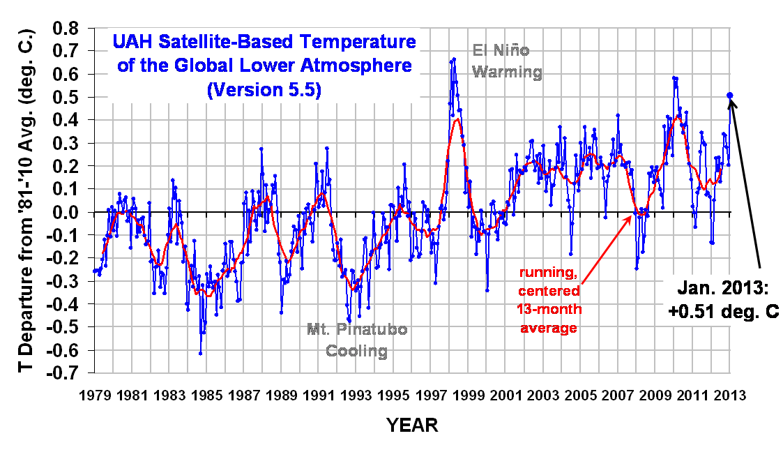
The global, hemispheric, and tropical LT anomalies from the 30-year (1981-2010) average for the last 13 months are:
YR MON GLOBAL NH SH TROPICS
2012 1 -0.134 -0.065 -0.203 -0.256
2012 2 -0.135 +0.018 -0.289 -0.320
2012 3 +0.051 +0.119 -0.017 -0.238
2012 4 +0.232 +0.351 +0.114 -0.242
2012 5 +0.179 +0.337 +0.021 -0.098
2012 6 +0.235 +0.370 +0.101 -0.019
2012 7 +0.130 +0.256 +0.003 +0.142
2012 8 +0.208 +0.214 +0.202 +0.062
2012 9 +0.339 +0.350 +0.327 +0.153
2012 10 +0.333 +0.306 +0.361 +0.109
2012 11 +0.282 +0.299 +0.265 +0.172
2012 12 +0.206 +0.148 +0.264 +0.138
2013 1 +0.506 +0.553 +0.459 +0.375
Due to the rather large 1-month increase in the temperature anomaly, I double checked the computations, and found that multiple satellites (NOAA-15, NOAA-18, and Aqua) all saw approximately equal levels of warming versus a year ago (January, 2012), so for now I’m accepting the results as real. The most common cause of such warm spikes (when there is no El Nino to blame) is a temporary increase in convective heat transfer from the ocean to the atmosphere. This would suggest that the global average sea surface temperature anomaly might have actually cooled in January, but I have not checked to see if that is the case.
Archived color maps of local temperature anomalies will be updated shortly are available on-line at http://nsstc.uah.edu/climate/;
The processed temperature data (updated shortly) is available on-line at http://vortex.nsstc.uah.edu/data/msu/t2lt/uahncdc.lt

 Home/Blog