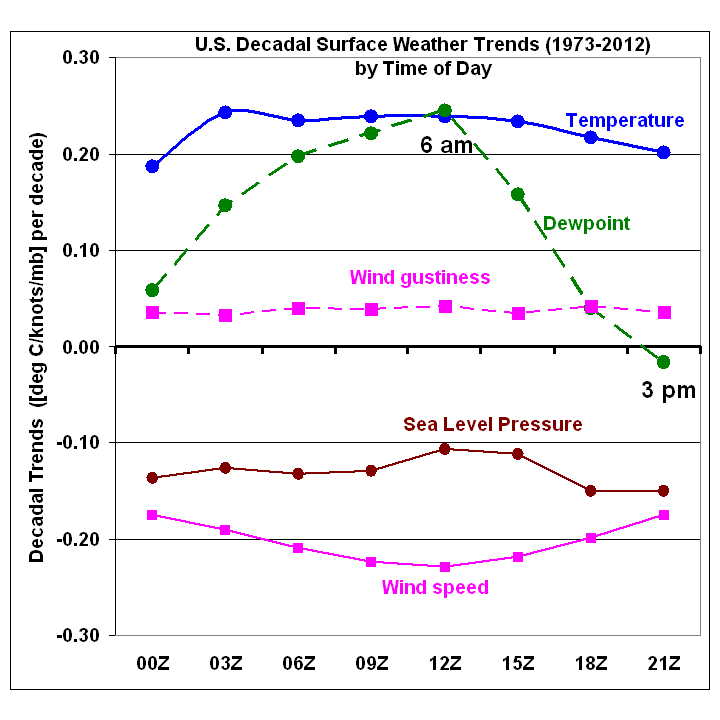
The Integrated Surface Hourly (ISH) weather data I have described before allows one to examine how various surface weather elements have changed as a function of time of day. (The ISH data volume is very large and it is not a trivial task to decode and analyze many years of it.) Three-hourly synoptic weather observations have been made at many U.S. weather stations for at least 40 years: 1973 seems to be the year when the number of stations reached a fairly large number, and so that is the year my analyses begin with.
I have previously mentioned that ISH surface data shows U.S. warming since 1973 (primarily a winter phenomenon, due to unusually cold winters in the 1970s), and a curious decrease in surface wind speed.
Here I�d like to point out another curiosity: while the dewpoint temperature has increased in step with air temperature at 12Z (around 6 a.m.), it has increased much less so at other times of the day, and even decreased slightly at 21Z (around 3 p.m.), during the period 1973-2012:

Assuming that dewpoint sensor design changes over the years have not introduced a diurnally varying measurement bias, a natural question arises: what would cause afternoon dewpoints to not rise in the face of warming both day and night? (Note I have not made any adjustments for sensor changes, siting changes, or urbanization in the above plot).
The first explanation that comes to my mind is a change in daytime convective mixing of the troposphere. If there is a slight increase in the depth of convective mixing, then drier (lower dewpoint) air aloft will be mixed down toward the surface. Such a change would probably also be associated with deeper moist convection and probably an increase in heavy rain rates, evidence for which has been claimed elsewhere (e.g. here). The implication of such a change for climate feedbacks is complicated and not obvious.
A second possibility is a long-term decrease in middle and upper tropospheric humidity, and no increase in convective mixing. In this case, daytime mixing would bring down the lower humidity air to the surface from the same altitude as before. There is some radiosonde evidence for such a decrease in absolute humidities above the turbulent boundary layer (e.g. Paltridge, 2009). If real, such a decrease might well result in negative water vapor feedback, since a small decrease in mid- and upper tropospheric humidity can have a natural radiative cooling effect which outweighs the warming from a larger increase in lower tropospheric humidity (e.g. Spencer and Braswell, 1997; Miskolczi, 2010). Of course, all climate models exhibit strongly positive water vapor feedback, approximately doubling the direct warming effect of increasing CO2 alone.
I don�t have a strong opinion on which of these possibilities (sensor problems, deeper convection, or a dryer mid- and upper troposphere) is more likely. Too little information, too many questions.

 Home/Blog


