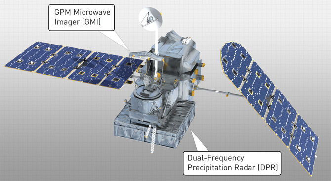
The Global Precipitation Mission (GPM) core observatory is scheduled to be launched from Japan at about noon (CST) on Thursday, Feb. 27. It will be in a 65 deg. inclination orbit, providing the first mid- and high-latitude coverage of precipitation systems with a precipitation radar.

The joint Japan-U.S. mission will be used with a variety of other satellites already orbiting the Earth that provide passive microwave imagery of precipitation systems to provide nominal 3-hourly coverage of most areas on a daily basis. A major focus of the core satellite will be the measurement of light precipitation, especially at mid- and high-latitudes, facilitated with a dual-frequency radar (14 GHz and 35 GHz; the TRMM satellite has only the lower frequency).
Clearly, precipitation is a key weather and climate variable, and its measurement from space has always been a challenge. Radars are the most direct method, but spaceborne precipitation radars have a practical limitation on swath width, and thus global coverage and sampling. So, we use the radars to “train” our passive microwave retrievals using data from the wide-swath microwave imagers, like the GMI (GPM Microwave Imager, with frequencies from 10 to 183 GHz).
I am particularly interested in precipitation processes from the standpoint of precipitation being what regulates how much of our main greenhouse gas — water vapor — is allowed to accumulate in the atmosphere from evaporation. I still think positive water vapor feedback in global warming theory is not a done deal (climate modelers consider it indisputable, magnifying any warming influence by about a factor of 2), and the lack of significant feedback might explain why the tropics have not warmed significantly (and the upper tropospheric hot spot has failed to materialize). See our paper, How dry is the tropical free troposphere? Implications for global warming theory (1997 BAMS).
My very first research publication as a post-doc was on measuring rainfall over land, which appeared as a cover article in Nature (1983). I was very active in the field for about 10-15 years before measuring temperature (rather than precipitation) with microwaves became my main research focus, although I still interface with many of those in the precipitation retrieval business.
This video animation of the GPM core satellite launch and deployment of the instruments and solar arrays is pretty cool (the rotating antenna is the microwave imager…the radar is electrically scanning, and sits on the bottom of the spacecraft):

 Home/Blog


