Archive for August, 2017

Houston Area Flooding Seen from Space

Thursday, August 31st, 2017

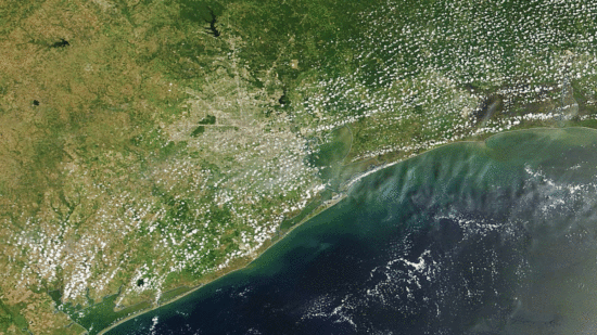
Today the skies cleared enough to see the huge amount of water flowing out of southeast Texas and Houston into the Gulf of Mexico.

Here is a before-and-after animation which shows the change from July 28 versus today (August 31), taken from the MODIS imager on NASA’s Terra satellite. Click on the image to enlarge and animate it.

Turbid water is seen flowing out up to 30 miles from the coast, with a huge plume exiting Galveston Bay.

Texas Major Hurricane Intensity Not Related to Gulf Water Temperatures

Tuesday, August 29th, 2017

As the Houston flood disaster is unfolding, there is considerable debate about whether Hurricane Harvey was influenced by “global warming”. While such an issue matters little to the people of Houston, it does matter for our future infrastructure planning and energy policy.

Let’s review the two basic reasons why the Houston area is experiencing what now looks like a new record amount of total rainfall, at least for a 2-3 day period over an area of tens of thousands of square miles.

1) A strong tropical cyclone, with access to abundant moisture evaporated off the Gulf of Mexico, and

2) Little movement by the cyclone.

These two factors have conspired to create the current flooding catastrophe in Houston. Now let’s look at them in the context of global warming theory.

1. Are Texas major hurricanes dependent on an unusually warm Gulf?

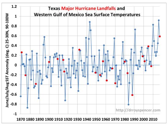
I examined all of the major hurricane (Cat 3+) strikes in Texas since 1870 and plotted them as red dots on the time series of sea surface temperature variations over the western Gulf of Mexico. As can be seen, major hurricanes don’t really care whether the Gulf is above average or below average in temperature:

Red dots indicate years of major hurricane strikes in Texas, plotted on average SST departures from normal by year over the western Gulf of Mexico (25-30N, 90-100W). Note I included Hurricane Ike in 2008, which was barely below Cat3, but had a severe impact.

Why is that? It’s because hurricanes require a unique set of circumstances to occur, and sufficiently warm SSTs is only one. (I did my Ph.D. dissertation on the structure and energetics of incipient tropical cyclones, and have published a method for monitoring their strength from satellites).

The Gulf of Mexico is warm enough every summer to produce a major hurricane. But you also usually need a pre-existing cyclonic circulation or wave, which almost always can be traced back to the coast of Africa. Also, the reasons why some systems intensify and others don’t are not well understood. This is why the National Hurricane Center admits their predictions of intensity change are not that accurate. Lots of thunderstorm complexes form over warm tropical waters, and we still don’t understand why some of them will spontaneously form a cyclonic circulation.

2. Does global warming cause landfalling hurricanes to stall?

I don’t know of any portion of global warming theory that would explain why Harvey stalled over southeast Texas. Michael Mann’s claim in The Guardian that it’s due to the jet stream being pushed farther north from global warming makes me think he doesn’t actually follow weather like those of us who have actual schooling in meteorology (my degree is a Ph.D. in Meteorology). We didn’t have a warm August in the U.S. pushing the jet stream farther north.

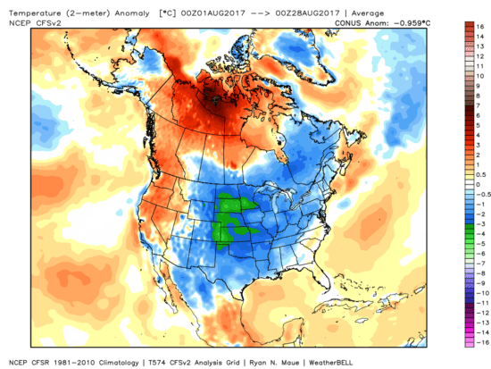
In fact, I dare anyone to look at the August temperature anomalies to date in the U.S. (courtesy of Weatherbell.com) and tell me, exactly what pattern here is due to global warming?

August 2017 (through Aug. 28) surface temperature anomalies around North America (NCEP CFSv2, courtesy of Weatherbell.com).

The flooding disaster in Houston is the chance occurrence of several factors which can be explained naturally, without having to invoke human-caused climate change. We already know that major landfalling hurricanes in the U.S. have been less frequent in recent decades. But once one forms, if it stalls near the coast (a rarity), it can be expected to cause a flooding disaster…especially in a flood-prone area like Houston.

NOTE: If you like my writing on this subject, please check out my new e-book, An Inconvenient Deception: How Al Gore Distorts Climate Science and Energy Policy.

Posted by Rush Limbaugh’s “artificial climatologist”. Ha-ha.

Why Houston Flooding Isn’t a Sign of Climate Change

Monday, August 28th, 2017

In the context of climate change, is what we are seeing in Houston a new level of disaster which is becoming more common?

The flood disaster unfolding in Houston is certainly very unusual. But so are other natural weather disasters, which have always occurred and always will occur.

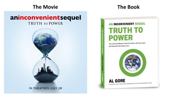
(By the way, making naturally-occurring severe weather seem unnatural is a favorite tactic of Al Gore, whose new movie & book An Inconvenient Sequel [ currently #21,168 in Kindle] is dismantled in my new e-book, An Inconvenient Deception [currently #399]).

Floods aren’t just due to weather

Major floods are difficult to compare throughout history because the ways in which we alter the landscape. For example, as cities like Houston expand over the years, soil is covered up by roads, parking lots, and buildings, with water rapidly draining off rather than soaking into the soil. The population of Houston is now ten times what it was in the 1920s. The Houston metroplex area has expanded greatly and the water drainage is basically in the direction of downtown Houston.

There have been many flood disasters in the Houston area, even dating to the mid-1800s when the population was very low. In December of 1935 a massive flood occurred in the downtown area as the water level height measured at Buffalo Bayou in Houston topped out at 54.4 feet.
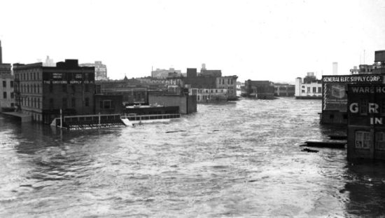
Downtown Houston flood of 1935.

By way of comparison, as of 6:30 a.m. this (Monday) morning, the water level in the same location is at 38 feet, which is still 16 feet lower than in 1935. I’m sure that will continue to rise.

Are the rainfall totals unprecedented?

Even that question is difficult to answer. The exact same tropical system moving at, say, 15 mph might have produced the same total amount of rain, but it would have been spread over a wide area, maybe many states, with no flooding disaster. This is usually what happens with landfalling hurricanes.

Instead, Harvey stalled after it came ashore and so all of the rain has been concentrated in a relatively small portion of Texas around the Houston area. In both cases, the atmosphere produced the same amount of rain, but where the rain lands is very different. People like those in the Houston area don’t want all of the rain to land on them.

There is no aspect of global warming theory that says rain systems are going to be moving slower, as we are seeing in Texas. This is just the luck of the draw. Sometimes weather systems stall, and that sucks if you are caught under one. The same is true of high pressure areas; when they stall, a drought results.

Even with the system stalling, the greatest multi-day rainfall total as of 3 9 a.m. this Monday morning is just over 30 39.7 inches, with many locations recording over 20 inches. We should recall that Tropical Storm Claudette in 1979 (a much smaller and weaker system than Harvey) produced a 43 inch rainfall total in only 24 hours in Houston.

Was Harvey unprecedented in intensity?

In this case, we didn’t have just a tropical storm like Claudette, but a major hurricane, which covered a much larger area with heavy rain. Roger Pielke Jr. has pointed out that the U.S. has had only four Category 4 (or stronger) hurricane strikes since 1970, but in about the same number of years preceding 1970 there were 14 strikes. So we can’t say that we are experiencing more intense hurricanes in recent decades.

Going back even earlier, a Category 4 hurricane struck Galveston in 1900, killing between 6,000 and 12,000 people. That was the greatest natural disaster in U.S. history.

And don’t forget, we just went through an unprecedented length of time – almost 12 years – without a major hurricane (Cat 3 or stronger) making landfall in the U.S.

So what makes this event unprecedented?

The National Weather Service has termed the event unfolding in the Houston area as unprecedented. I’m not sure why. I suspect in terms of damage and number of people affected, that will be the case. But the primary reason won’t be because this was an unprecedented meteorological event.

If we are talking about the 100 years or so that we have rainfall records, then it might be that southeast Texas hasn’t seen this much total rain fall over a fairly wide area. At this point it doesn’t look like any rain gage locations will break the record for total 24 hour rainfall in Texas, or possibly even for storm total rainfall, but to have so large an area having over 20 inches is very unusual.

They will break records for their individual gage locations, but that’s the kind of record that is routinely broken somewhere anyway, like record high and low temperatures.

In any case, I’d be surprised if such a meteorological event didn’t happen in centuries past in this area, before we were measuring them.

And don’t pay attention to claims of 500 year flood events, which most hydrologists dislike because we don’t have enough measurements over time to determine such things, especially when they also depend on our altering of the landscape over time.

Bill Read, a former director of the National Hurricane Center was asked by a CNN news anchor whether he thought that Harvey was made worse because of global warming. Read’s response was basically, No.

“Unprecedented” doesn’t necessarily mean it represents a new normal. It can just be a rare combination of events. In 2005 the U.S. was struck by many strong hurricanes, and the NHC even ran out of names to give all of the tropical storms. Then we went almost 12 years without a major (Cat 3 or stronger) hurricane strike.

Weird stuff happens.

I remember many years ago in one of the NWS annual summaries of lightning deaths there was a golfer who was struck by lightning. While an ambulance transported the man to the hospital, the ambulance was stuck by lightning and it finished the poor fellow off.

There is coastal lake sediment evidence of catastrophic hurricanes which struck the Florida panhandle over 1,000 years ago, events which became less frequent in the most recent 1,000 years.

Weather disasters happen, with or without the help of humans.

Hurricane Harvey: 1 Million Hiroshima Bombs per Day

Friday, August 25th, 2017

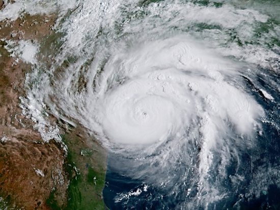
Hurricane Harvey off the east coast of Texas at 9:30 a.m. CDT August 25, 2017, as seen by the new GOES-16 satellite (CIRA/CSU processing).

Mother Nature routinely deals with huge amounts of energy. In the case of hurricanes, some of the solar energy stored in the upper ocean is rapidly removed by strong winds in the form of evaporated water vapor, which then feeds the hurricane as the vapor condenses into rain and the “latent heat of condensation” is released.

That heating causes the warm core of the hurricane, creating the “eye” and producing the strong winds circling the eye. The rain itself falls back to the surface, and in the coming week eastern Texas will no doubt be dealing with one of the worst flooding disasters on record with 1 to 3 feet of rain.

The amount of energy released in such a storm is staggering. It can be computed that the average hurricane releases the energy equivalent of 10 Hiroshima-class bombs every second.

That’s approximately 1 million atomic bombs per day. Given Harvey’s size and intensity, I suspect the real number is even larger.

As the above image shows, nature can be beautiful and dangerous at the same time.

Skeptic Beating Al Gore on Amazon

Thursday, August 24th, 2017

Al Gore’s new movie, An Inconvenient Sequel: Truth to Power, has been in theaters for about a month now, and has received rather tepid reviews.

The Kindle e-book version of Gore’s movie, despite being very colorful, has been doing even worse and is currently running at #20,768 overall on Amazon, and is not ranked #1 in any sub-category.

But the skeptic take-down of Gore’s new movie and book, An Inconvenient Deception: How Al Gore Distorts Climate Science and Energy Policy, is at #956, and is #1 in three sub-categories.

What makes the discrepancy even worse is that An Inconvenient Deception was self published, with no paid advertising.

Maybe people are finally wising up to Mr. Gore.

Space Station Crossed the Sun During Eclipse

Wednesday, August 23rd, 2017

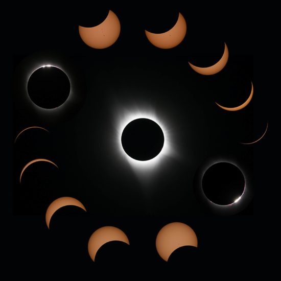
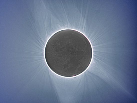
Now that a day or so has passed since the total solar eclipse raced across the United States, we are beginning to see some of the better photos from professional photographers appear.

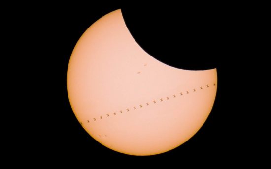
I’ve gathered a handful of what I consider to be some of the best photos so far. I think the most unique photo was by Canadian photographer Derek Kind, who travelled to a remote spot in Wyoming just to capture the International Space Station crossing the sun at the same time as the moon was crossing. I’ve witnessed the ISS crossing the sun before, and you have to be in just the right place at just the right time to witness it.

ISS passing in front of the sun during the eclipse, Derek Kind, somewhere in Wyoming.

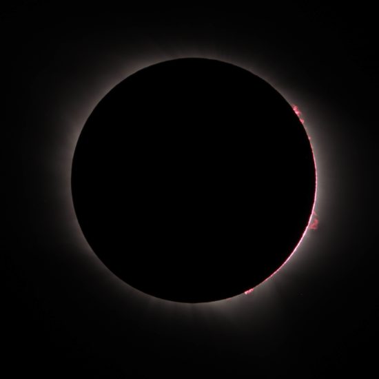
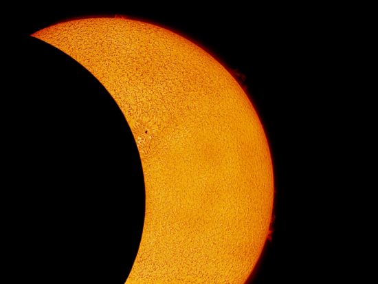
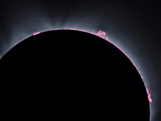
The following photos are also exceptional.

Prominences, Dave Cotterell, Glendo, Wyoming.

Using a hydrogen alpha filter and small telescope, by “V3ngence”, Livermore, California.

Moshen Chan, Madras, Oregon.

Jimmy Eubanks, Sunset, South Carolina.

Multi-exposure composite, showing Earthshine reflecting off the dark side of the moon. Joe Woolbright, unknown location.

A video of people gathered to capture the Space Station transiting the sun can be seen here.

Total Eclipse from Center Hill Lake, TN

Tuesday, August 22nd, 2017

My family and friends drove north from Huntsville, AL the 2-3 hours to get into the path of totality. The weather was better than usual. As we drove into Tennessee, scattered cumulus and towering cumulus clouds were forming.

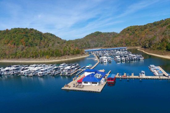
Our preferred destination was Hurricane Marina, 50 miles east of Nashville. This is a beautiful and rather remote spot on Center Hill Lake, and it has huge houseboats owned (I assume) by some of the wealthier people in Nashville.

Hurricane Marina on Center Hill Lake, 50 miles east of Nashville.

The two concerns driving there were traffic and the weather. Traffic was not too bad. We had previously decided to take the back roads as much as possible. Scattered clouds were forming, but I hoped that the skies would be clearer around the lake, which is large and often suppresses convection during fair weather.

When we arrived the parking lot — which is huge — was already full. We walked out on the dock to the restaurant/store, and set up folding chairs in the red tent with the blue roof in the photo, to the right of the main building. It was very warm and humid, typical for Tennessee in August.

I started setting up my two camera tripods at the lower-right corner of the platform the restaurant and shop are on. It was then that I realized the entire dock was floating (even the one with the store & restaurant) and it wouldn’t be stable enough for time lapse photography.

So, we watched the sun become covered by the moon with our eclipse glasses. The surroundings darken so gradually you barely notice the effect.

Then I suddenly realized all of the clouds were gone. The reduction in solar heating was just enough to cause the convective thermals to weaken and not penetrate the inversion that was no doubt present.

I decided to carry my equipment to the rocky shoreline in the left-center portion of the above photo. By the time I got there the landscape was getting darker by the second. I set up both tripods up the bank a ways and realized my main camera would not get both the lake surface and the sun in the frame, even at 15 mm focal length, which is very wide angle.

I quickly took one tripod to the water’s edge, set it up on three unstable rocks, inserted my intervalometer that controls the timing of the photos, and… the little button battery fell out into the water under one of the rocks.

I quickly found it, dried it, inserted it, set it to 2 second intervals and started it up. Here’s the resulting time lapse video… this is high-def, so if you watch full-screen at 1080p, you will see Jupiter at left-center.

I set the camera to a fixed exposure so you could see just how dark it gets during totality; the start of the video, even though overexposed, is when the moon has covered the sun by 97-98%, so it was already pretty dark. The video is running 30 times faster than real time.

As the sky quickly darkened, I rushed to the other tripod and placed my Nikon P900 superzoom, which I only use for video at high magnification, on it. I had already decided to not fool with the settings, and just let it run on “auto” and see what I got. The camera took video for about 5 minutes, and I learned afterward it was having difficult focusing.

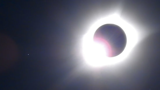
Here are a couple of screen shots from the video:

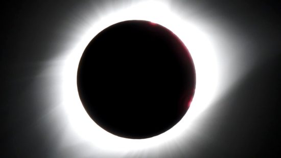
“Diamond ring” effect just before totality, with Regulus to the left.

Late in totality.

I was surprised how quickly it becomes dark as totality approaches. We had 2 minutes and 38 seconds of totality. Just as soon as totality started, fish near me jumped out of the water, and birds and crickets started chirping.

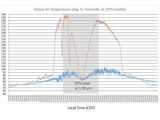
Back in Huntsville, which experienced 97% of totality, I was taking air temperatures every 10 sec in our backyard. I took ambient air temperature, as well as the air temperature in a Styrofoam cooler, painted black inside, with Saran Wrap covering it. The ambient air temperature drop during the maximum portion of eclipse was about 10 deg. F, while temperature drop in the cooler was over 100 deg. F.

Air temperatures outside (blue trace) and inside a Styrofoam cooler (other 2 traces) during the solar eclipse in Huntsville, AL, 21 August 2017.

It was a thoroughly enjoyable experience. This was my first total eclipse, and we were indeed fortunate to have good weather for it.

An Inconvenient Deception: How Al Gore Distorts Climate Science and Energy Policy

Saturday, August 19th, 2017

Al Gore has provided a target-rich environment of deceptions in his new movie.

After viewing Gore’s most recent movie, An Inconvenient Sequel: Truth to Power, and after reading the book version of the movie, I was more than a little astounded. The new movie and book are chock-full of bad science, bad policy, and factual errors.

So, I was inspired to do something about it. I’d like to announce my new e-book, entitled An Inconvenient Deception: How Al Gore Distorts Climate Science and Energy Policy, now available on Amazon.com.

After reviewing some of Gore’s history in the environmental movement, I go through the movie, point by point.

One of Gore’s favorite tactics is to show something that happens naturally, then claim (or have you infer) that it is due to humanity’s greenhouse gas emissions. As I discuss in the book, this is what he did in his first movie (An Inconvenient Truth), too.

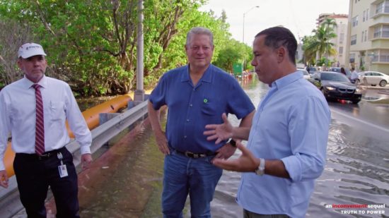
For example, sea level rise. Gore is seen surveying flooded streets in Miami Beach.

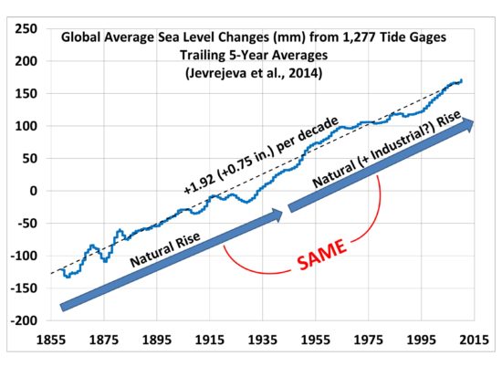
That flooding is mostly a combination of (1) natural sea level rise (I show there has been no acceleration of sea level rise beyond what was already happening since the 1800s), and (2) satellite-measured sinking of the reclaimed swamps that have been built upon for over 100 years in Miami Beach.

In other words, Miami Beach was going to have to deal with the increasing flooding from their “king tides”, with or without carbon dioxide emissions.

Gore is also shown jumping across meltwater streams on the Greenland ice sheet. No mention is made that this happens naturally every year. Sure, 2012 was exceptional for its warmth and snow melt (which he mentioned), but then 2017 came along and did just the opposite with record snow accumulation, little melt, and the coldest temperature ever recorded in the Northern Hemisphere for a July.

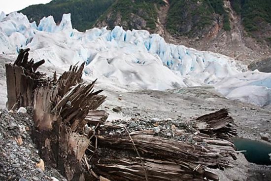
The fact that receding glaciers in Alaska are revealing stumps from ancient forests that grew 1,000 to 2,000 years ago proves that climate varies naturally, and glaciers advance and recede without any help from humans.

So, why is your SUV suddenly being blamed when it happens today?

The list goes on and on.

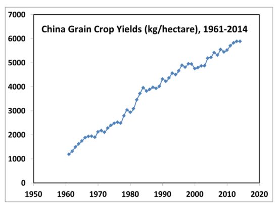
Some of what Gore claims is just outright false. He says that wheat and corn yields in China are down by 5% in recent decades. Wrong. They have been steadily climbing, just like almost everywhere else in the world. Here’s the situation for all grain crops in China:

And that lack of rainfall in Syria that supposedly caused conflict and war? It didn’t happen. Poor farmers could no longer afford diesel fuel to pump groundwater because Assad tripled the price. Semi-arid Syria is no place to grow enough crops for a rapidly growing population, anyway.

I also address Gore’s views on alternative energy, mainly wind and solar. It is obvious that Gore does not consider government subsidies when he talks about the “cost” of renewable energy sometimes being cheaper than fossil fuels. Apparently, he hasn’t heard that the citizens pay the taxes that then support the alternative energy industries which Gore, Elon Musk and others financially benefit from. If and when renewable energy become cost-competitive, it won’t need politicians and pundits like Mr. Gore campaigning for it.

To counter what is in movie theaters now, I had to whip up this book in only 2 weeks, and I didn’t have a marching army of well-funded people like Gore has had. (Too bad he didn’t have someone doing fact-checking.) Despite my disadvantage, I think I present a powerful case that most of what he presents is, at the very least, very deceptive.

UAH Global Temperature Update for July, 2017: +0.28 deg. C

Tuesday, August 1st, 2017

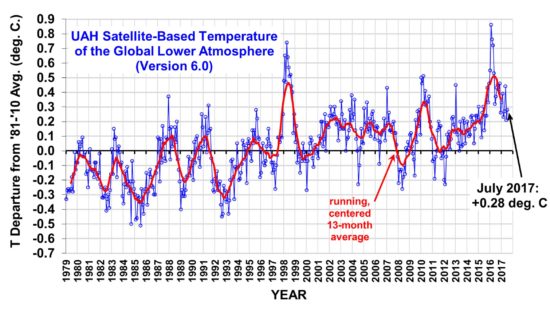
The Version 6.0 global average lower tropospheric temperature (LT) anomaly for July, 2017 was +0.28 deg. C, up a little from the June, 2017 value of +0.21 deg. C (click for full size version):

Global area-averaged lower tropospheric temperature anomalies (departures from 30-year calendar monthly means, 1981-2010). The 13-month centered average is meant to give an indication of the lower frequency variations in the data; the choice of 13 months is somewhat arbitrary… an odd number of months allows centered plotting on months with no time lag between the two plotted time series. The inclusion of two of the same calendar months on the ends of the 13 month averaging period causes no issues with interpretation because the seasonal temperature cycle has been removed as has the distinction between calendar months.

The global, hemispheric, and tropical LT anomalies from the 30-year (1981-2010) average for the last 19 months are:

YEAR MO GLOBE NHEM. SHEM. TROPICS
2016 01 +0.55 +0.73 +0.38 +0.84
2016 02 +0.86 +1.19 +0.52 +0.99
2016 03 +0.76 +0.99 +0.54 +1.10
2016 04 +0.72 +0.86 +0.58 +0.93
2016 05 +0.53 +0.61 +0.45 +0.71
2016 06 +0.32 +0.47 +0.17 +0.38
2016 07 +0.37 +0.43 +0.30 +0.48
2016 08 +0.43 +0.53 +0.32 +0.50
2016 09 +0.45 +0.50 +0.39 +0.38
2016 10 +0.42 +0.42 +0.41 +0.46
2016 11 +0.46 +0.43 +0.49 +0.36
2016 12 +0.26 +0.26 +0.27 +0.23
2017 01 +0.33 +0.32 +0.33 +0.09
2017 02 +0.39 +0.58 +0.19 +0.07
2017 03 +0.23 +0.37 +0.09 +0.06
2017 04 +0.27 +0.29 +0.26 +0.22
2017 05 +0.44 +0.39 +0.49 +0.41
2017 06 +0.21 +0.32 +0.09 +0.39
2017 07 +0.28 +0.29 +0.27 +0.51

The linear temperature trend of the global average lower tropospheric temperature anomalies from January 1979 through July 2017 is now +0.13 C/decade.

NOTE: In June 2017 we added the Metop-B satellite to the processing stream, with data since mid-2013. The Metop-B satellite has its orbit actively maintained, so the AMSU data from it does not require corrections from orbit decay or diurnal drift. As a result of adding this satellite, most of the monthly anomalies since mid-2013 have changed, by typically a few hundredths of a degree C.

The UAH LT global anomaly image for July, 2017 should be available in the next few days here.

The new Version 6 files should also be updated in the coming days, and are located here:

Lower Troposphere: http://vortex.nsstc.uah.edu/data/msu/v6.0/tlt/uahncdc_lt_6.0.txt
Mid-Troposphere: http://vortex.nsstc.uah.edu/data/msu/v6.0/tmt/uahncdc_mt_6.0.txt
Tropopause: http://vortex.nsstc.uah.edu/data/msu/v6.0/ttp/uahncdc_tp_6.0.txt
Lower Stratosphere: http://vortex.nsstc.uah.edu/data/msu/v6.0/tls/uahncdc_ls_6.0.txt