Friday the 13th is not shaping up to be very lucky for some people, weather-wise.
A strong springtime (or late winter?) storm currently moving across the northern and central Rockies will move east over the next several days with a wide variety of severe weather, including blizzard conditions to the north and severe thunderstorms to the south.
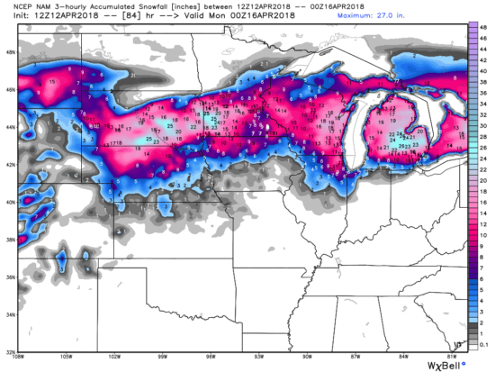
By Sunday evening, a foot or more of snow accumulation is expected over portions of Nebraska, South Dakota, Wisconsin, Michigan, and Minnesota (including Minneapolis-St. Paul). Up to 2 feet is possible in some areas. Chicago and Detroit could see as much as 6-12 inches.
The latest forecast from NOAA’s NAM model is roughly consistent with previous U.S. and European forecast model runs, but the exact path of the heaviest snowfall has been somewhat uncertain, especially for Wisconsin and Michigan (all graphics courtesy of Weatherbell.com):

Forecast total snowfall by Sunday evening April 15, 2018, from NOAA’s NAM forecast model run on Thursday morning, April 12.
By Tuesday, portions of 30 to 35 states will see some snowfall, with flurries extending as far south as eastern Tennessee and central Missouri. It will snow almost continuously for 3-4 days (Friday through Monday) over portions of northern Wisconsin and northern Michigan. I-90 east of Rapid City will probably have to be closed by Friday night.
The unusually large low pressure area extending from the Canadian border to the Gulf coast will produce an array of weird and wild weather.
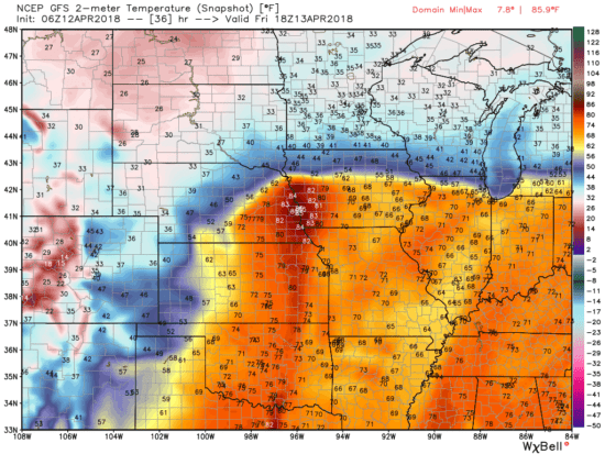
For example, by tomorrow (Friday) afternoon, eastern Nebraska will be in the mid-80s, while heavy snow and blizzard conditions will exist over the western part of the state. Only a few tens of miles will separate summer weather from winter weather across the Midwest and the southern Great Lakes:

Surface temperature forecast for early afternoon Friday April 13 from the GFS model run at midnight April 12.
Severe thunderstorms will move across the Southern Plains on Friday and the southeast U.S. on Saturday as the accompanying cold front moves eastward.
Yes, sometimes it snows in April.
And Friday the 13th might not turn out to be very lucky for you if you plan on traveling in the northern Midwest.

 Home/Blog


