
 Home/Blog
Florida residents must feel like they have been taking a beating from major hurricanes in recent years, but what do the data show?
The problem with human perception of such things is that the time scale of hurricane activity fluctuations is often longer than human experience. For example, a person born in the 1950s would have no memory of the beating Florida took in the 1940s from major hurricanes (a total of 5). But they would have many memories of the hurricane lull period of the 1970s and 1980s, each decade having only one major hurricane strike in Florida. Then, when an upswing in hurricane strikes occurs, it seems very unusual to them, and they assume that “hurricanes are getting worse”.
Another problem is that any statistics for an area as small as Florida, even over 100+ years, will be pretty noisy. Landfalling hurricanes for the eastern U.S. would be a better metric. And statistics for the entire Atlantic basin would be even better, except that satellite coverage didn’t start until the 1970s and hurricane intensity in remote areas before then would be poorly measured (or not measured at all).
Finally, tropical cyclone statistics for the entire tropics would be the best (if one was trying to determine if climate change is impacting cyclone intensity or frequency). But satellite data for the global tropics is, again, limited to the period since the 1970s. Global tropical cyclone data before the 1970s is sketchy, at best.
So, keeping in mind that any trends we see for Florida are going to be strongly influenced by the “luck of the draw” and the quasi-random nature of hurricane tracks (hurricanes are steered by the large-scale flow of air in the mid-troposphere, say around 20,000 ft altitude or so), what are the statistics of Florida major hurricane intensity and frequency since 1900?
Florida Major Hurricane Intensity & Number
The following plot shows the intensity of major hurricanes (100 knots or greater maximum sustained wind speed) striking Florida since 1900, updated through recent (2024) Hurricane Helene:
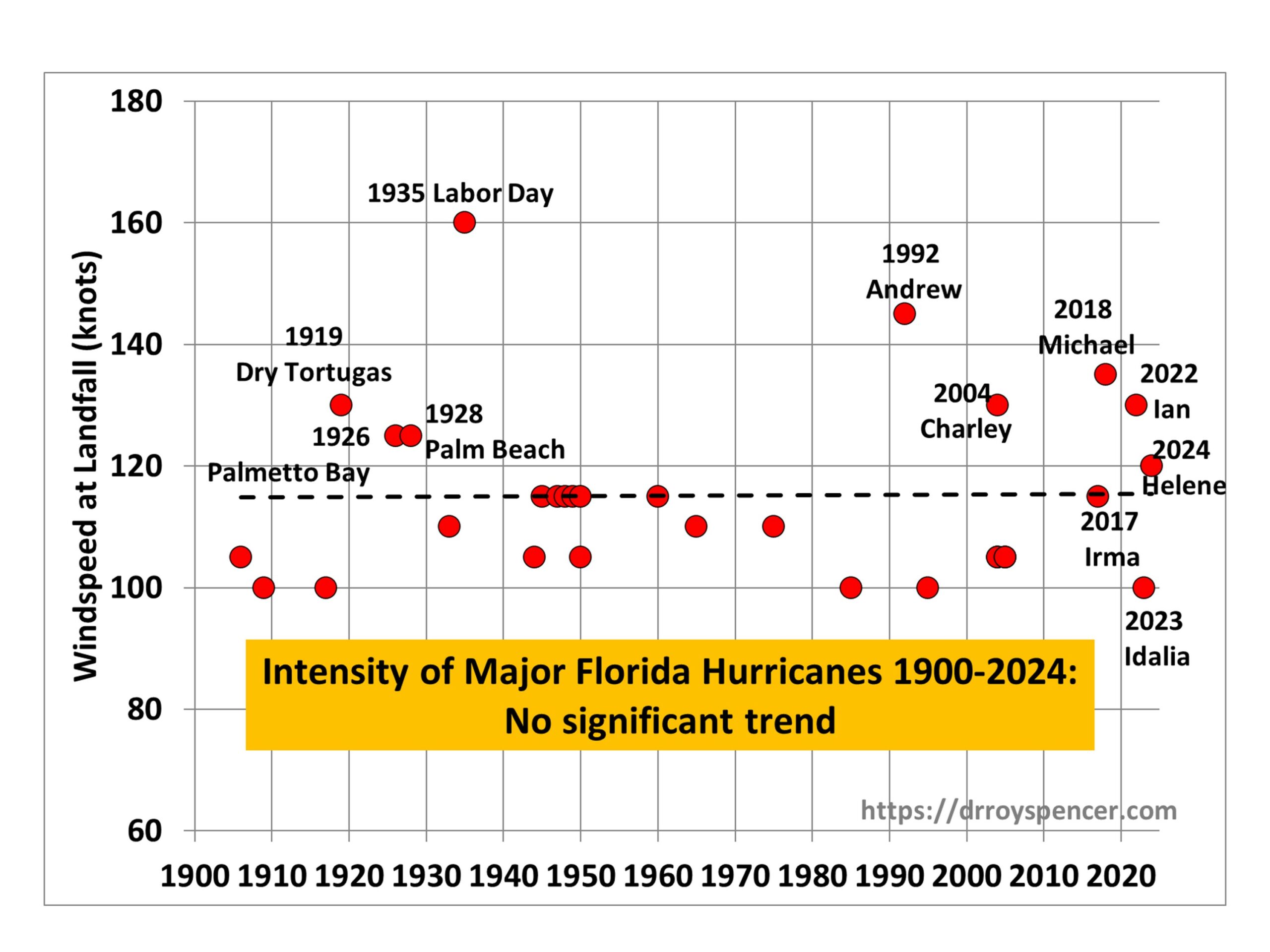
As can be seen from the linear trend line, there has been no significant trend in the intensity of major hurricanes striking Florida since 1900.
But what about the number of hurricanes? The next plot shows there has been a weak upward trend in the decadal totals of major hurricanes striking Florida since 1900:
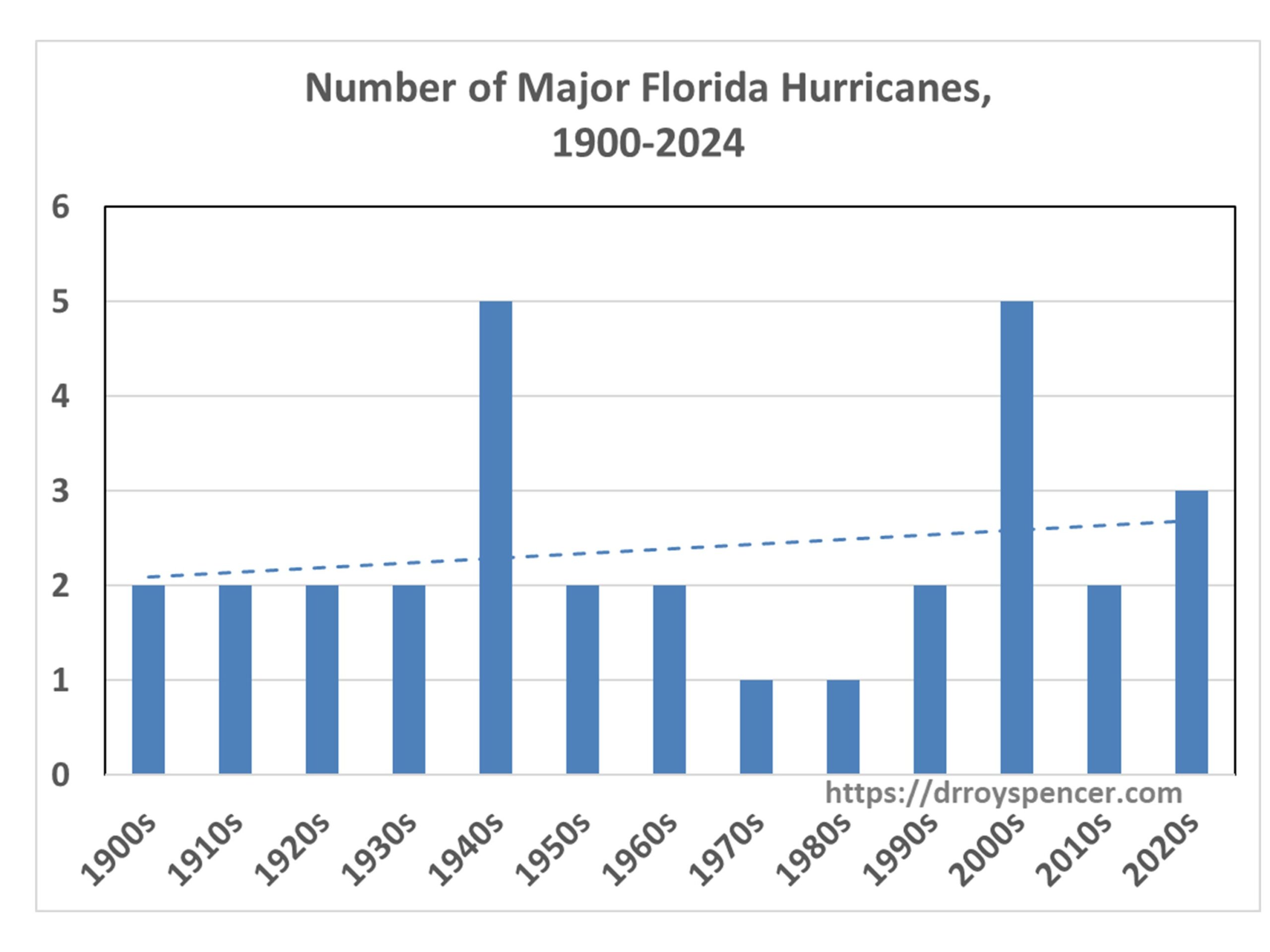
Note that the 2020s number might well increase, since the end of the current (2024) hurricane season will be only half-way through the 2020s. While Hurricane Milton has just been classified as a major hurricane, in 2 days time it is expected to be under increasing wind shear, so it is not obvious it will strike Florida as a major hurricane, and so I did not include it in the above charts.
Another feature of the second chart above shows that a native Floridian born in the 1960s or 1970s would indeed have experienced an increase in major hurricanes striking Florida during their lifetime. But their first couple of decades of personal experience would have occurred during a historic lull in hurricane activity.
Why Start In 1900?
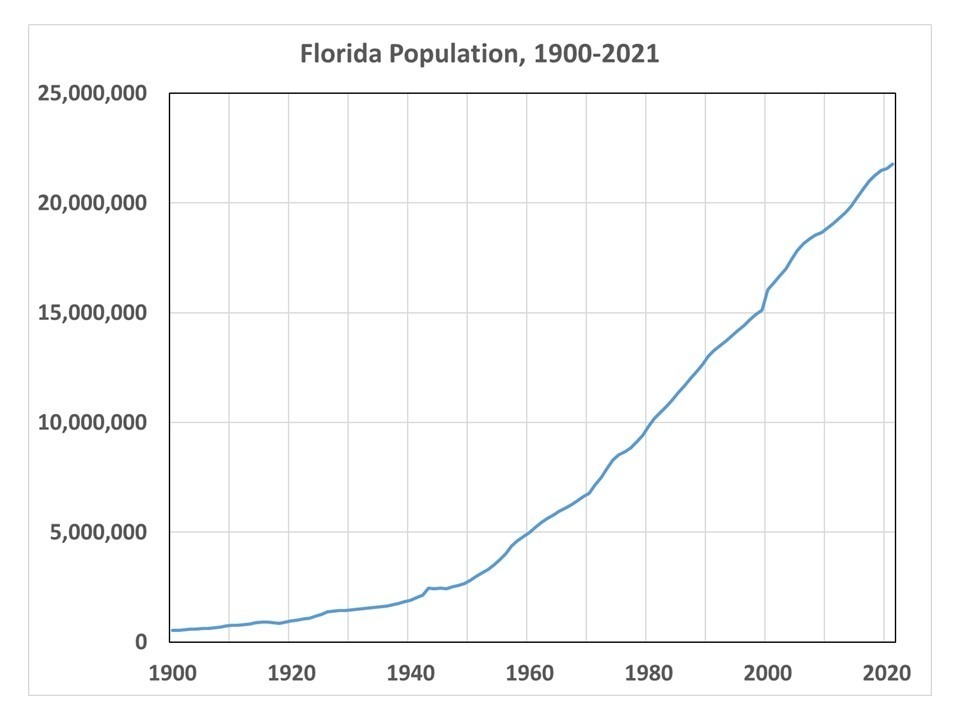
There is reason to believe that the number and/or intensity of major hurricanes striking Florida in the early 1900s has been underestimated, which would bias the trends in the above plots in the upward direction, spuriously suggesting a long-term increase in activity. First of all, there were virtually no people living in Florida in 1900. The population of Miami in 1896 was 444 persons. The intensity of a hurricane is based upon its maximum sustained 1 minute windspeed, which usually covers a very small area. Even with people now inhabiting much of the Florida coastline, it is rare for a coastal anemometer to measure the intensity that the National Hurricane Center gives to a hurricane, because those winds cover such a small area. So, how could it ever be known how intense some hurricanes were in the early 1900s?
Evidence for Long-Term Hurricane Fluctuations Unrelated to Water Temperature
Modern concern centers on the possibility that warm sea surface temperatures from global warming caused by anthropogenic CO2 emissions is making hurricanes stronger or more frequent. But studies of coastal lagoon sediments along the Gulf coast and Caribbean deposited by catastrophic hurricane landfalls show large fluctuations in activity on centennial to millennial time scales, even in the absence of the unusually warm sea surface temperatures measured today. (Example here.)
It should also be remembered that not long ago the U.S. experienced an “unprecedented” 11-year drought in major hurricane strikes. That significantly impacts our perception of what is “normal”. When the lull had reached 9 years, a NASA study found such an event was a 1-in-177-years occurrence. As I recall, that was increased to 1-in-250 years when the lull reached 11 years.
The point is that there is a huge amount of natural decadal- to centennial-time scale variability in hurricane activity in Florida (or any other hurricane-prone state). But with increasing numbers of people thinking that the government is somehow influencing hurricane activity (I’m seeing a lot of this on Twitter), I doubt that actual data will have much influence on those people, and as I approach 70 years on this Earth I have noticed a long-term decline in critical thinking regarding weather, climate, and causation. I doubt that trend will change any time soon.


> As can be seen from the linear trend line
There are 4 dots above trend between 1900 and 1992.
There are 5 between 1992 and 2024.
And Milton is not on the list, just turned Cat 5.
I used to be concerned with hurricanes getting into the Gulf of Mexico.
Now it seems they are much more likely to form and spin up in the Gulf.
Receipts?
Perhaps this:
> Milton is now one of the strongest hurricanes ever recorded with maximum sustained winds of 180 mph (285 km/h)
https://bsky.app/profile/bnonews.com/post/3l5xacrxpey23
See also Fox News Orlando.
And also:
https://www.drroyspencer.com/2024/10/florida-major-hurricanes-1900-2024-what-do-the-statistics-show/#comment-1691330
160 knots and 180 mph are approximately the same speed.
If you convert that plot to mph it elevates all those dots by about 14%.
After all the hype from one of our resident alarmists, the hurricane made landfall as a Cat 3. Still devastating but within the natural variability of past hurricanes.
The graphs will need to be updated. Especially the second one.
I wonder why this one does not make the rounds in contrarian circles.
” Still devastating but within the natural variability of past hurricanes.”
But the natural variability of hurricanes is shifting to stronger and faster developing hurricanes.
See Patricia
https://en.wikipedia.org/wiki/Hurricane_Patricia
and Otis
https://en.wikipedia.org/wiki/Hurricane_Otis
“On record” sounds like a long time but it is 67 years. OK, so you can say the two most recent “biggest” are the biggest in the last 67 years. The implication is humans are causing the warming which is causing stronger hurricanes. Show us your evidence.
Dr Spencer has provided an excellent statistical analysis of the history of hurricanes by looking at trends over 100+ years. He also discusses the more recent improvements in the level and accuracy of monitoring which may account for some of the perceived if not actual differences in observations compared with the early-to-mid 1900s. You, along with others seem intent of focusing on a small number of data points (many commenters now seeing nothing but Milton) in an apparent attempt to change the statistical analysis. This is not how statistics works.
If man made CO2 is the cause of those last 5 dots than the 4 dots between 1910 and 1940 should not have existed. Those were the CO2 happy days we all want to return to. Utopia.
There is no uptrend, not even in Florida. And the strength measured is highly dependent on the technology used. https://anderdaa7.substack.com/p/are-modern-hurricanes-rated-to-high
“….we have no idea what past storms would be rated if they had been monitored 24/7 out at sea, and at land fall, and with the same methods used now. For instance, what would this storm have been today? October 11, 1846 The Great Havana Hurricane of 1846 passed near Key West with an estimated pressure of 902 mbar (hPa) and winds of possibly Category 5 status,[39] damaging or destroying all but 6 of the houses in the city. 50 are killed,[40] and damage amounts to $200,000 (1846 USD, $4.8 million 2008 USD). It is estimated it struck mainland Florida near Cedar Key,[41] producing severe flooding and strong winds.[6]
Or this one? (note the actual storm surge which matches what was predicted for Tampa when they thought Milton would hit as a Cat 4 or 5 ) … September 25, 1848 The Great Gale of 1848 strikes near Tampa as a major hurricane with an estimated pressure of 948 mbar.[6] Considered one of the most significant hurricanes in the Tampa area, the 15 foot (4.6 m) storm surge from the hurricane destroyed much of Tampa and nearby Fort Brooke.[42)
Or the double hitter that struck Florida 17 days later on October 11, 1848 A major hurricane hits northwestern Florida, causing additional damage to the severe hurricane a few weeks before.[43] ( So media claims of what happened to Florida with Helena and Milton hitting so close being unprecedented, is false.)
So, from 1842 to 1848 Florida was struck by four major hurricanes, often producing much more storm surge and wind damage than Helena or Milton this year. Exactly zero of them were caused by CO2 emissions from people, cars, or cows.
In additon to past storms I mentioned above, Governor DeSantis had a great response when asked about Climate Change affecting Milton and Helena. I think there have been about 27 hurricanes that have had lower barometric pressure on landfall than Milton did. And of those, 17 occurred, I think, prior to 1960. If he went back 10 years further he could have added 4 more, and then 21 of the 31 strongest Florida hurricanes would have all occurred well before Climate Change claimes. and Milton would not make the list. He also stated, And the most powerful hurricane on record since the 1850s in the state of Florida occurred in the 1930s, the Labor Day hurricane. Barometric pressure on that was 892 millibars. It totally wiped out the keys. and he mentioned how in 1928, the Okeechobe hurricane killed over 4,000 people.”
See much more at the post…
Again, Florida landfalls are a fraction of all hurricanes. Better stats could be obtained by looking at all hurricanes or all land-falling hurricanes. (Yes, as I stated… but Floridians are freaking out. -Roy)
There were no airplane’s flying into hurricanes until the mid 1940s. So I’m skeptical of the hurricane strength ratings before then. (Me too. -Roy)
Going back to the 1940s, one can clearly see a significant increase in the number of very strong hurricanes hitting Florida. (And paleo evidence from the Gulf coast of Florida shows extreme hurricane activity filling coastal lakes many centuries ago… so what?? -Roy)
And now be have another cat 4, Milton headed that way.
Sea surface T is the gas pedal for hurricanes.. All else being equal, don’t you think warmer sea surface T should produce stronger storms, Roy? As we are seeing in real time with Milton, now cat 5.
I’ve already addressed your strawman, Nate. Nothing else stays the same in nature. If the IPCC thought you were right, don’t you think AR6 would have said so?
“Hurricanes have been intensifying more rapidly since the 1980s (high confidence) and causing heavier rainfall and higher storm surges (high confidence).”
5th National Climate Assessment.
NOAA GFDL says
“Tropical cyclone rainfall rates are projected to increase in the future (medium to high confidence) due to anthropogenic warming and accompanying increase in atmospheric moisture content. ”
“Tropical cyclone intensities globally are projected to increase (medium to high confidence) on average (by 1 to 10% according to model projections for a 2 degree Celsius global warming).”
“The global proportion of tropical cyclones that reach very intense (Category 4 and 5) levels is projected to increase (medium to high confidence) due to anthropogenic warming over the 21st century.”
” Nothing else stays the same in nature.”
But conditions favorable to hurricane formation are still present this time of year, apparently. When we do form, it appears that they can be strengthened by warmer SST, as we have seen with Milton and Helene, anothers in recent years.
Only thing is, they are not more intense at landfall, or more frequen.
We have no idea what past storms would be rated if they had been monitored 24/7 out at sea, and at land fall, and with the same methods used now. For instance, what would this storm have been today? October 11, 1846 The Great Havana Hurricane of 1846 passed near Key West with an estimated pressure of 902 mbar (hPa) and winds of possibly Category 5 status,[39] damaging or destroying all but 6 of the houses in the city. 50 are killed,[40] and damage amounts to $200,000 (1846 USD, $4.8 million 2008 USD). It is estimated it struck mainland Florida near Cedar Key,[41] producing severe flooding and strong winds.[6]
Or this one? (note the actual storm surge which matches what was predicted for Tampa when they thought Milton would hit as a Cat 4 or 5 ) … September 25, 1848 The Great Gale of 1848 strikes near Tampa as a major hurricane with an estimated pressure of 948 mbar.[6] Considered one of the most significant hurricanes in the Tampa area, the 15 foot (4.6 m) storm surge from the hurricane destroyed much of Tampa and nearby Fort Brooke.[42)
Or the double hitter that struck Florida 17 days later on October 11, 1848 A major hurricane hits northwestern Florida, causing additional damage to the severe hurricane a few weeks before.[43] ( So media claims of what happened to Florida with Helena and Milton hitting so close being unprecedented, is false.)
So, from 1842 to 1848 Florida was struck by four major hurricanes, often producing much more storm surge and wind damage than Helena or Milton this year. Exactly zero of them were caused by CO2 emissions from people, cars, or cows.
In additon to past storms I mentioned above, Governor DeSantis had a great response when asked about Climate Change affecting Milton and Helena. I think there have been about 27 hurricanes that have had lower barometric pressure on landfall than Milton did. And of those, 17 occurred, I think, prior to 1960. If he went back 10 years further he could have added 4 more, and then 21 of the 31 strongest Florida hurricanes would have all occurred well before Climate Change claimes. and Milton would not make the list. He also stated, And the most powerful hurricane on record since the 1850s in the state of Florida occurred in the 1930s, the Labor Day hurricane. Barometric pressure on that was 892 millibars. It totally wiped out the keys. and he mentioned how in 1928, the Okeechobe hurricane killed over 4,000 people,”
Hurricanes are complex and rapid forming hurricanes are not unusuall historically. During 1957, five storms originated in the Gulf of Mexico, including major hurricane Audrey, which rapidly intensified, made landfall on June 27 and killed more than 400 people. The US hasnt been hit by a hurricane during June in almost 40 years. In 1969, Hurricane Camille rapidly intensified and came ashore in Mississippi with sustained winds at least 190 MPH. According to NASA, temperatures in the Gulf Of Mexico were low that year.
Papers showing an increase in rapid intensification fail to properly account for several major changes in our ability to track such storm systems, which have taken several leaps from the beginning of airplane flights, to dropsondes, to satellites, to more and better satellites with improved Doppler, to more planes and more flights.
The bottom line, theres been no increase in hurricane strength or frequency no emergency there.https://i0.wp.com/wattsupwiththat.com/wp-content/uploads/2021/04/maue-ace-2022.png?resize=768%2C540&ssl=1global hurricane frequency, both for all hurricanes and for the strongest hurricanes.
https://i0.wp.com/wattsupwiththat.com/wp-content/uploads/2021/04/maue-hurricane-frequency-2022.png?resize=768%2C553&ssl=1Here are the records of all hurricanes (left) and major hurricanes (right) that came ashore in the US in the last 150 years NO increasehttps://www.nature.com/articles/s41467-021-24268-5
Pacific typhoons (hurricanes) for Japan and China also show zero increase in frequency or intensity. If it is NOT manifesting on land, where people live, the statical manipulation of complicated data and varied methods of collecting claiming more rapid intensification are meaningless. (It is a bit like tide gages vs satellites. The gages show what folk actually deal with on the ground, where the other is complex and highly technical, and not cogent to actual observed SL rise.)
Also modern hurricanes are over rated, compared to the past…
https://anderdaa7.substack.com/p/are-modern-hurricanes-rated-to-high
Roy Spencer says:
” Modern concern centers on the possibility that warm sea surface temperatures from global warming caused by anthropogenic CO2 emissions is making hurricanes stronger or more frequent. But studies of coastal lagoon sediments along the Gulf coast and Caribbean deposited by catastrophic hurricane landfalls show large fluctuations in activity on centennial to millennial time scales, even in the absence of the unusually warm sea surface temperatures measured today. ”
The link below provides statistics on North Atlantic hurricanes and named storms.
https://docs.google.com/presentation/d/1_6dx__SonNE7-1LX6uZAjlY5LC9Z7tpyKp-G2UFY6IE/edit?usp=sharing
Ive plotted the number of hurricanes and storms alongside the North Atlantic Sea Surface Temperature (SST). Interestingly, there appears to be a strong correlation between SST and the frequency of hurricanes and storms, even when excluding data prior to 1900.
I would appreciate Spencer’s comments on this, as the findings seem to contradict his statement.
The source of the data shown above: https://www.stormfax.com/huryear.htm
I have a question regarding wind speeds. The surface winds as measured at multiple buoys recorded sustained maximum wind speeds of only 40kts with gusts to 60 in the path of Milton. Are the published speeds recorded at a standard altitude? When anticipating hurricane damage, isnt the surface wind the main driver of storm surge and property damage?
Historic old hurricanes were best measured by storm surge and barometric pressure when possible.
https://anderdaa7.substack.com/p/are-modern-hurricanes-rated-to-high
Roy,
with all due respect I must point out that the following assertion is peak solipsism …
We have to think of ourselves as centered in a five-generation continuum. A person born in the 1950s benefited from the lived experiences of parents and grandparents, and will pass on their own experiences to their children and grandchildren.
Regarding the technical aspects of your post, It’s been pointed out since at least the 1980s that there is no reason to expect changes in the frequency of hurricanes with short term man-made climate change. However, because they make “textbook examples of a Carnot engine,” their maximum intensity will increase with increasing sea surface temperature.
*** Arkady: If nothing else changes, you are correct. But what if there are fewer (or more) seedlings coming off the African continent? What if vertical wind shear increases, reducing hurricane intensity? It’s a complex issue that goes beyond simple “Carnot cycle” arguments. Go back and read my paragraph about the evidence for ~1,000 year fluctuations, unrelated to sea surface temperature. This is why even the IPCC has not projected changes that can be attributed to “global warming”. -Roy
This is worth a read too:
https://www.nature.com/articles/s41598-023-42669-y
Observed increases in North Atlantic tropical cyclone peak intensification rates
Regards.
Roy,
You referenced Donnelly et al 2007 but excluded Donnelly et al 2015, where they write:
Yes, “It’s a complex issue that goes beyond simple ‘Carnot cycle’ arguments.” But that’s no reason to ignore the tendency of the local thermodynamic environment.
The only agreement i see ,is the fact climate changes, its that simple.
“However, because they make textbook examples of a Carnot engine, their maximum intensity will increase with increasing sea surface temperature.”
Actually what counts in a Carnot cycle is not sea temperature rise but the difference in temperature between sea and air. This remains about unchanged. What sea temperature rise can do is translate the birth location of tropical cyclones to higher laritudes.
“the difference in temperature between sea and air. This remains about unchanged.”
I very much doubt that, since that would imply that the lapse rate is changing and, there is no evidence of that.
The carnot eff is not the main issue. It is the availability of fuel, which is water vapor convected from the ocean. Turns out convection is a very strong function of sea surface temperature.
What I learned in bubblehead school was that the condensation is what drives drop in pressure.
So more evaporation leads to more condensation which leads to more pressure drop which leads to higher wind speeds and higher storm surge.
Higher sea surface temperatures lead to stronger hurricanes.
Interesting. Makes sense.
Sometimes I want to squish an empty milk bottle. I heat up the last remnants of milk in microwave. Put the top on.
The steam condenses inside making a partial vacuum. It squishes all on its own.
Not that I think this changes the analysis much, but Michael 2018 was 140 kts at landfall.
C’mon. man. Hurricane Michael is in the plots, above. Did you even read the article?
Yes. Michael 2018 appears in the plot as 135 kts, but it was actually 140 kts at landfall.
https://www.nhc.noaa.gov/data/tcr/AL142018_Michael.pdf
bdgwx says:
”Yes. Michael 2018 appears in the plot as 135 kts, but it was actually 140 kts at landfall.”
No there is in range of uncertainty for new strategies for measuring hurricane strength that has only recently become available. Its in the paragraph you referenced plus or minus 10%. So its a range of 126kts to 154kts.
If you want to compare storm strength over time you need to carefully be consistent in the technology used to estimate the landfall wind speeds.
Thus the way its displayed in the graph is likely correct assuming a qualified expert on this topic knows his stuff.
If you go back to 1900, you might be lucky to have one of several anemometers left operational after the peak winds passed.
No doubt the uncertainty is larger as you go back in time. It would be convenient if we had a time machine and could go back do it the modern way. But that will have to wait until the technology is available to do that.
BH: Thus the way its displayed in the graph is likely correct assuming a qualified expert on this topic knows his stuff.
Let me make sure I’m understanding your argument here. So even though the landfalling intensity is 140 kts you are saying it is correct to display it as 135 kts? No?
Its actually an accounting standard bdgwx. If you use a different method of estimating an account balance you have to go back and restate all the previous years using the same method when displaying it in a comparative manner.
That doesn’t prevent anybody from preferring the 140kt figure and using it in non-comparative situations.
An example in science is when Leif Svalgaard adjusted the sunspot record about a decade ago because he long felt that the methods of counting sunspots had varied over time and that there may have been some calls on sunspots in recent history that weren’t visible before the technology had improved.
So Leif put together a study that he thought consistently counted sunspots based upon what information he was able to gather that appeared to be the closest to a consistent way of counting them. And as a result his work was accepted.
Leif Svalgaard is a CO2 activist in his spare time and a leading solar scientist in his profession. His motivation arose out of a lot of declarations by skeptics that increasing sun spots might be evidence of solar warming being the primary increase in surface forcing instead of CO2 warming. Leif from his experience didn’t think that was true. So he put together everything he could find about the technology and the words of solar observers and determined a common way of looking at sunspots over the years.
I happened to read his paper to see if he was following best practices in his work and I came away thinking he had. Its not perfect but nothing is. I always assume that a scientist does his best until it becomes obvious he didn’t. And what he did and the data he used should be well described and the data made available to others. That often is not the case. Like a high school or college teacher grading term projects, if any of that is missing you get a lower grade. Unfortunately in academic areas this is overlooked without any across the board peer review checking off if best practices are consistently used. Not enforcing that makes for a lot of lousy papers.
So yes bdgwx. The maximum winds in the 2018 hurricane was properly stated at 135kts considering the purpose of the study was to compare hurricanes over the decades.
But we know better technology detected some higher sustained winds in this hurricane and its OK to consider it for all non-comparative purposes as being a hurricane of 140kts. This would not prevent this hurricane being displayed in a future comparative study at 140kts that was a more modern look at comparing say 2018 to say 2068 where all the hurricanes are using the same methods. but if technology continued to advance over that time as it probably will that will have to be accounted for by using a common method of detecting the maximum winds in future hurricanes.
there should be nothing at all confusing about why the two figures for the hurricane each has its place where its appropriate to use it.
> Its actually an accounting standard
I pretty much doubt it, but this squirrel has nothing to do with the report:
https://www.nhc.noaa.gov/data/tcr/AL142018_Michael.pdf
But first, baby steps. Report. Not “paper.”
BH: So yes bdgwx. The maximum winds in the 2018 hurricane was properly stated at 135kts considering the purpose of the study was to compare hurricanes over the decades.
So reporting 135 kts when the actual value is 140 kts is called “properly stated”?
Why not subtract 5 kts on all hurricanes so that can all be “properly stated” as well?
I wonder how this works in general. Is the 0.96 C value for September UAH TLT “properly stated” or is it the actual value? If it’s not “properly stated” then how should Dr. Spencer report it so that it is “properly stated”?
bdgwx says:
”So reporting 135 kts when the actual value is 140 kts is called properly stated?
Why not subtract 5 kts on all hurricanes so that can all be properly stated as well? /of course that would be silly/
I wonder how this works in general. Is the 0.96 C value for September UAH TLT properly stated or is it the actual value? If its not properly stated then how should Dr. Spencer report it so that it is properly stated?”
Did you read my post bdgwx? I think if you did you didn’t comprehend the point I was making.
When comparing items as in the graph you and Roy were talking about you need a common method of measurement for the purpose of comparison. That means using the same means of measure to the extent possible. Thats why its inappropriate to tag an instrument record on to the end of say and ice core proxy.
I didn’t say you needed to always say the max winds in the hurricane was 135kts. 140kts was recorded by doppler radar.
But using older technology as a common means of measurement is just plain good science when trying to show a trend.
This should be common sense. In the case of accounting its required. And I have seen scientists revert to the same standard and I gave you an example of that.
For instance I am following Milton. Its reported to have come ashore as a category 3. But looking at weather station reporting the highest wind gauge measurement I have seen is 94mph which is a Cat 1. Even then modern hurricanes have a leg up because they may have an order of magnitude more calibrated anemometers than Galveston had in 1900
Go back in the first half of the 20th century all we had were weather stations with anemometers to record the onshore wind speeds. Is it proper to claim Milton was a cat 3 when it came ashore when say the standard weather station using an anemometer says it was a cat 1 when it came ashore?
As a note what I said about Milton is a preliminary comparison to historical hurricanes. I got the reports off the NHC public advisory and they may not have all them or the worst of them listed. So the above is just an example of the differences in technology and it might not be the historical wind speed appropriate for a comparison to historic hurricanes.
Yeah you can still say the 2018 hurricane was 140kts. But its misleading to use that information in a comparison where the argument is hurricanes have been increasing in intensity and the number only came from more modern and capable technology.
We still have weather stations. If you are going to do that comparison it behooves you to find a common method of measurement to measure them for the purpose of comparison and using only land based anemometers would be the best way to proceed to do that. I don’t know if ”operational data” was a land based anemometer reading or not, but we know its wasn’t doppler radar. And thats a good thing for good science.
And I also recognize that using advanced technology is far better for forecasting the threat than waiting for the report to come in from the surviving weather station after the power is restored. So we can still use both for different purposes.
> Why not subtract 5 kts
It would not change anything, as it is the relative speed that matters.
Why the other wall of words?
BH,
All of the hurricanes in that plot have their intensities set the exact same way. It’s based on the HURDAT reanalysis using hurricane models. If you don’t like Michael’s 140 kts then you’re not going to be satisfied with any of the hurricane intensities in Roy’s plot. That’s my point.
And regarding Milton I think you may be confused on realtime hurricane wind speeds are assigned. They are not assigned based on arbitrary observations. They are assigned based on the maximum observation. Whether it is right or wrong that’s how it is done. And recon flights confirm that Milton’s maximum winds were in the NW quadrant over the ocean.
bdgwx says:
BH,
All of the hurricanes in that plot have their intensities set the exact same way. Its based on the HURDAT reanalysis using hurricane models. If you dont like Michaels 140 kts then youre not going to be satisfied with any of the hurricane intensities in Roys plot. Thats my point.
And regarding Milton I think you may be confused on realtime hurricane wind speeds are assigned. They are not assigned based on arbitrary observations. They are assigned based on the maximum observation. Whether it is right or wrong thats how it is done. And recon flights confirm that Miltons maximum winds were in the NW quadrant over the ocean.
———————
Well lets not forget that it is you who is complaining about a value in that chart that was reanalyzed with Hurdat data.
But you haven’t made a case for why the ”reanalyzed” data is wrong.
Its obvious that 1928 Palm Beach hurricane and a far smaller sampling rate than one would have today.
And like digital audio the sampling rate increases the highs and decreases the lows with a higher sampling rate.
BH: Well lets not forget that it is you who is complaining about a value in that chart that was reanalyzed with Hurdat data.
There is clearly a gross misunderstanding here. All of the data in the chart is from HURDAT and is correct except the dot for Michael 2018. HURDAT I’m simply asking Dr. Spencer to fix the mistake.
BH: But you havent made a case for why the reanalyzed data is wrong.
You’re right I haven’t made a case for why the “reanalyzed” data is wrong. And I have no intention of doing so because I don’t think it is wrong. That’s actually the crux of my point. HURDAT (the official record) says Michael 2018 was 140 kts at landfall. Dr. Spencer made a mistake and listed it as 135 kts in his plot.
And BTW…I find Dr. Spencer’s response to me bizarre. It appears he is insinuating that I didn’t read article. Yet, it is precisely because I read the article and double checked his plot that I was able to see the mistake. I don’t know why this has to be so complicated. It’s a trivial mistake and likely an innocent typo so why Dr. Spencer doesn’t just fix it is odd.
bdgwx says:
BH: Well lets not forget that it is you who is complaining about a value in that chart that was reanalyzed with Hurdat data.
There is clearly a gross misunderstanding here. All of the data in the chart is from HURDAT and is correct except the dot for Michael 2018. HURDAT Im simply asking Dr. Spencer to fix the mistake.
BH: But you havent made a case for why the reanalyzed data is wrong.
Youre right I havent made a case for why the reanalyzed data is wrong. And I have no intention of doing so because I dont think it is wrong. Thats actually the crux of my point. HURDAT (the official record) says Michael 2018 was 140 kts at landfall. Dr. Spencer made a mistake and listed it as 135 kts in his plot.
——————-
Well it might not be Roy. there are plenty of different estimates for hurricane strength and a lot of the wind speeds are calculated from offshore data, storm surge size, and barometric pressure.
For instance this source, Moody’s, puts Milton at 106mph 15 to 20 miles off of approximately Manasota Key well south of Sarasota.
Damages from that area look more intense than in the more northern areas that are getting most of the press. But 106mph puts it at Category 2.
For Milton it appears that storm surge caused most of the water damage and spin off tornados most of the wind damage. I have a close friend who rode it with the eye passing over the house while he spent the night watching the news on Orlando Channel 2 with only a single loss of electricity for a few minutes.
Your source puts michael at about 161mph. But at Tyndall AFB where the top wind speed in Hurdat2 is recorded the Air Force last year published an update on its recovery for the base still saying 155mph top wind speed (135kt). so who is right the Air Force or your reanalysis team?
Your reanalysis team concedes it may be in error by as much as 14kt.
Probably the best metric to go by for Hurricanes is the entire state of Florida in the 21st century has had 651 people out of a population of 23 million die of hurricanes in total.
Galeston TX lost 8,000 lives in a single night in 1900 and the number may have been as high as 12,000. thats the real story. A story of stupendous success with advancing technology that is saving countless lives.
You are just racehorcing, Bill:
> Haynes said the secret to his legal advocacy was to have the answer to any prospective question from a judge or prosecutor or if an answer wasn’t at the ready, be prepared to change the subject. At an American Bar Association seminar in New York in the late 1970s, Haynes explained how to plead in the alternative: “Say you sue me because you claim my dog bit you. Well now, this is my defense: My dog doesn’t bite. And second, in the alternative, my dog was tied up that night. And third, I don’t believe you really got bit. And fourth, I don’t have a dog.”
https://en.m.wikipedia.org/wiki/Richard_Haynes_(lawyer)
Well Willard its an interesting topic. I note that the Galveston 1900 hurricane, killing 8,000, making it not just the most deadly hurricane in the US History but the most deadly natural disaster in US history had a highest wind speed of 100mph before the only anemometer blew away and the lowest barometric pressure that was recorded was 964.4mb.
All that was adjusted to 145mph(125kt) and 936mb by no doubt a groups of experts pontificating that it must have been stronger. I am just pointing out that even the current ratings are recognized to be only accurate between + or – 10%. Older rankings not being instrument measures but guesstimated are thought to be accurate within +or- 15%. Seems like a reasonable guesstimate. But exactly how does one go about looking for trends in such data? No doubt real accountants potential liable for their work would write a few pages of stuff about the uncertainty of the results. How say you?
That’s more galloping, Bill.
Bill, it sounds like you understand why utilizing real-time observations and only real-time observations is a problem and why a more rigorous post-mortem analysis incorporating information not known in real-time is necessary to correctly categorize hurricanes so I’m not understanding what the problem is here.
And if you if you think the uncertainty of 10% or 15% or whatever it is justification for not excepting the best estimate of the maximum wind speed then fine. Reduce the estimate of maximum wind speed by 10%, 15%, or whatever. Just make sure you do it ALL hurricanes in the database and not just the ones occurring later in the period of record.
bdgwx says:
”Reduce the estimate of maximum wind speed by 10%, 15%, or whatever. Just make sure you do it ALL hurricanes in the database and not just the ones occurring later in the period of record.”
I don’t know why you think just reducing them would be meaningful. Don’t you understand that with such an error margin its not at all likely you can find any statistically significant conclusions or any trend in such data?
**That’s possible. -Roy
As it stands its obvious the Galveston hurricane of 1900 had its maximum measured wind speed elevated by 45% and its measured barometric pressure reduced greatly. All that seems to have been done in recognition of the structural damage. But its still below the Michael Hurricane of 2018 despite having a higher estimated storm surge than Michael.
**Yes, from what I’ve read, those houses were just sticks, and there was no structural protection against a storm surge. -Roy
Also, Michael’s storm surge estimated at Mexico Beach which is in funnel shaped bay that geographically increases the height of the surge. In other words there is a lot more to hurricanes than estimated maximum wind strength which is going to favor measuring that wind strength before the wind hits a wall or spins an anemometer
**I agree. -Roy
I realize that the level of science scrutiny around here is to draw a line through the averages and ignore the statistical significance. But statistical significance is what science is all about. Ignoring it isn’t science and its likely there will never be in the next 1,000 years a statistically significant change in hurricane strength.
** Yes, there are studies of coastal lagoon overwash events that suggest multi-centennial period of more catastrophic hurricanes, then fewer. -Roy
Be happy though that without that all those fossil fuel emissions have made hurricanes much safer.
A little common sense from the public would go a long ways.
**I don’t see that happening anytime soon. -Roy
Everything has its pluses and minuses and we aren’t at all served by people claiming otherwise. We also aren’t served by ignorant politicians investing in projects to change the world, limit our freedoms, and continuing to support the largest corporations in the world poisoning us with honest to God pollution not fake pollution to distract from what is important.
We know from much experience that politicians engaging in world change is a process of stealing from one group to make another group richer.
*** !!! How could you assert such a crazy thing!! – Roy
If you want to change the world start a business and sell it. Politics though isn’t the place for it. Good politics is about disclosure, ensuring transparency, restricting fraudulent and deceptive marketing, consistent enforcement, and demanding honest disclosures about uncertainty.
bdgwx says:
”Reduce the estimate of maximum wind speed by 10%, 15%, or whatever. Just make sure you do it ALL hurricanes in the database and not just the ones occurring later in the period of record.”
Unfortunately there are a lot of people around here and in academia that seems to believe that would be an appropriate way to conduct a scientific examination.
You do understand that the + or – error margin is what defines statistics as being capable of providing an answer that is based in science as opposed to just pure alarmism. We have a lot of that going on in climate science that embarrassing a lot like UFO theories.
Yes I don’t know anything that you can’t imagine something bad coming from, likewise imagining something good. But the only statistical evidence we have of hurricane damage is a vast improvement in hurricane safety over the industrial age. If some bad has arisen from it be sure not to throw the baby out with the bathwater. Unfortunately mostly what is going on is a distraction from how the middle class and lower classes have been attacked and how major international corporations are centrally responsible.
Heck our policies are even driving the energy sector overseas. Very decidedly anti-American.
How much do you think the energy sector is responsible for more deaths over the industrial age. . .conservatively?
Brian Mcclure Meteorologist
Monday midday update: yep, its a Cat 5 now.
Although its expected to weaken as it nears our coast it will still push a lot of water with the surge. Take the surge evacuation serious!
If this track pans out it will be the worst hurricane Tampa Bay has seen since 1921.
This is the one we prep for folks. We can get through this. Leave the evacuation areas if youre in one and get to a sturdy structure at higher ground. Our concrete buildings can sustain the wind with proper shutters/windows. If youre in a low area remember you dont have to evacuate farjust stay with friends/family/shelter/hotel on higher ground. Sometimes thats only a few miles inland.
Dont freak out, but rather buckle down and get everything ready. The recovery is the hardest part. WE CAN AND WILL GET THROUGH THIS.
https://www.tropicaltidbits.com/storminfo/
—Hurricane Milton ‘explosively intensifies’ with winds of 175 mph
Denise Chow
Hurricane Milton has explosively intensified, with maximum sustained winds of 175 mph, according the latest bulletin from the National Hurricane Center.
The agency said Milton is now a “potentially catastrophic” Category 5 storm on the Saffir-Simpson Hurricane Wind Scale, which ranks hurricanes from 1 to 5 based on a storms maximum sustained wind speed.
“While fluctuations in intensity are expected, Milton is forecast to remain an extremely dangerous hurricane through landfall in Florida,” the NHC said.—
https://www.nbcnews.com/news/weather/live-blog/hurricane-milton-live-updates-rcna174253
Linked from: https://instapundit.com/
“WE WERE HAVING SUCH A NICE, QUIET HURRICANE SEASON: Hurricane Milton live updates: Now a monster Category 5 storm as Florida orders evacuations.
Posted at 12:53 pm by Glenn Reynolds
Hurricane Milton in Mexico: Devastating winds and storm surges expected on Yucatan Peninsula; see tracker
“The storm is expected to move near the Yucatan Peninsula on Monday and Tuesday morning before moving through the Gulf of Mexico and making landfall in Florida later this week.”
https://www.usatoday.com/story/weather/2024/10/07/hurricane-milton-mexico-yucatan-peninsula/75558448007/
“Weeks after a strong hurricane developed in the Gulf of Mexico, another storm, Hurricane Milton, has strengthened to a powerful Category 5 storm on Monday with sustained winds of 160 mph as it nears Mexico’s Yucatan Peninsula.
Milton went from a Category 2 to 5 in only a matter of hours on Monday. Before making an expected landfall later this week, Miltons intensity should weaken but still threaten the Florida coast as a major and deadly hurricane, the National Hurricane Center said in an advisory.””
…
The hurricane will not be sheared as it will be in a loop of upper-level lows, which may even increase the rainfall mass.
https://earth.nullschool.net/#2024/10/10/0200Z/wind/isobaric/500hPa/orthographic=-76.83,33.54,1002
Another claim is rapid intensification. Milton has sustained winds of 175 mph as of the 1 PM CDT update. That is a very strong Cat 5. Maybe we need a new Cat 6 rating (sarcasm). It seems that claim can only be made or refuted with modern data from hurricane hunter aircraft. Is there any data on rate of increase of wind speed or decrease of central pressure?
Hurricanes have been intensifying more rapidly since the 1980s (high confidence) and causing heavier rainfall and higher storm surges (high confidence).
5th National Climate Assessment.
5th Climate Assessment brings to mind the Dunning Kruger Effect.
https://i.ibb.co/Z8yxDg5/ventusky-rain-ac-20241010t0800-28n80w.jpg
https://i.ibb.co/fxh80CH/ventusky-pressure-20241010t0200-2742n8234w.jpg
I think the world would be much better off (much, much better off) if we all agreed to the following:
— climate changes
— carbon dioxide is an unlikely primary driver
For those of us who are old enough, we do remember a period that appeared to have been colder, roughly 1970-ies, give and take. This period, incidentally, seems to show up in the data shown in this post.
During the cooling period, same kinds of people who allege runaway warming today were alleging runaway cooling due to particulate and aerosol pollution. If nothing else, it stands to reason that a cleanup of said pollution could have pushed the temperatures back up, towards what the temperature was (we think) in the 1930-ies and 1940-ies.
The reflexive response of “anti-alarmist” crowd (you can count me in that crowd) is that nothing has been changing. It is kind of a trap, in my opinion. There is no reason to believe that nothing is changing. The “tragedy” of the present day climate science is that we don’t really understand climate change, because of “carbon dioxide extremism” which forcibly marginalizes anyone who even hypothesizes something else.
“The reflexive response”
As opposed to an evidence-based thoughtful response?
Do you think a guy like ‘mf’ would provide even the tiniest bit of anything like data or a chart to back up his dumb claims?
Never, ever!
*
This is why I call such brazen boys ‘pseudo-skeptic’.
Another analysis is to look at the proportion of landfalling Florida hurricanes that are major (category 3-5) in each decade. This proportion has increased strongly since 1900. Here’s the list by decade:
1900 0.33
1910 0.22
1920 0.44
1930 0.29
1940 0.67
1950 0.33
1960 0.25
1970 0.33
1980 0.33
1990 0.33
2000 0.63
2010 0.50
2020 0.67
Interesting stat, thanks.
Sometimes Wikipedia has good information. These various records do not really show trends over time in any way. They seem random. Some of them are recent. For obvious reasons, all of the death toll records are old, and all of the cost records are recent:
https://en.wikipedia.org/wiki/List_of_Atlantic_hurricane_records
Be nice to see these analyzed, and put in graphical form.
But it seems clear that the period after 2000 has a high fraction of the strongest hurricanes, 9 of top 20.
SOLAR MINIMUM UPDATE
NBC6 Hurricane Specialist John Morales realized that Milton had become a Category 5 monster storm on Monday just before he went on air at noon.
He paused for a moment, visibly emotional, and his voice shook as he expressed his disbelief.
“It’s just an incredible, incredible, incredible hurricane. It has dropped,” he stopped. “It has dropped 50 millibars in 10 hours. I apologize. This is just horrific.”
Morales went on: “Maximum sustained winds are 160 mph. And it is just gaining strength in the Gulf of Mexico where the winds — I mean, the seas, are just so, incredibly, incredibly hot. Record hot, as you might imagine. You know what’s driving that. I don’t need to tell you: global warming, climate change [are] leading to this and becoming an increasing threat for the Yucatan, including Merida and Progreso and other areas there.”
https://www.nbcmiami.com/news/local/just-horrific-john-morales-becomes-emotional-over-miltons-explosive-growth/3437225/
“I have noticed a long-term decline in critical thinking regarding weather, climate, and causation. I doubt that trend will change any time soon.”
Let’s hope that was not insulting and that it’s only irrelevant.
Meanwhile:
https://www.youtube.com/watch?v=poHGZW-mg_M
Ken
Maybe the Hurricane Specialist John Morales forgot about Wilma.
https://en.wikipedia.org/wiki/Hurricane_Wilma
I think you and me both find the same thing when looking at extreme weather. It was really bad just a few years back. Seems memory is short so it is a good thing for the written word.
It is correct that hot water has the potential to create more powerful hurricanes but it is not the only variable. It is okay to suggest hurricane intensity could increase as the planet warms but there are many factors that go into producing a severe weather event. As one factor might make it more likely some other factor may decrease it and the net effect is neutral. With the complexity involved in severe weather (like a tornado outbreak in the middle US) it is a challenge to pin just one factor like a warming planet to an increase in all extreme weather events.
I keep an open mind to the possibility but do not like the current media push that all extreme weather is increasing because of a warming planet. I agree with Dr. Spencer on this point.
Perhaps Norman forgets that, in contrast to him, hurricane expert John Morales was reporting has been reporting on hurricanes since before he himself was playing Climateball:
https://www.mensjournal.com/news/veteran-meteorologist-tears-hurricane-milton
It’s alright for men to cry. No need to act tough all the times.
Malboro Man died of lung cancer anyway.
Willard
Then explain why Morales forgot about Wilma which underwent rapid intensification and dropped 97 mbar in 24 hours and had wind speeds sustained up to 185 mph?
As an expert he would have fit Milton in along with a few others. It is a very bad storm but not something that has not already happened with much less global warming (2005 vs 3024).
Here:
https://en.wikipedia.org/wiki/List_of_Atlantic_hurricane_records
This gives information on past hurricanes. If you would be a real scientist (research and investigate) you would find Milton is in the top 10 but not the top storm in record.
I do not like when experts do not use context. You can appeal to authority to attempt your display of superiority but it is not a scientific position.
Science means you look at ALL data available to form conclusions. Morales is not doing this when he claims Milton is caused by climate change. He is fueling the manipulation of ignorant minds to accept things as science that are not.
You bring up the false claims of the tobacco industry. That is what is being done here in the opposite direction. Waiting for any bad weather event in the world and automatically claiming it is climate change. That is really bad science and it is what Dr. Spencer is attempting to challenge.
> Then explain why Morales forgot
Simple. He did not:
https://www.motherjones.com/environment/2024/10/hurricane-milton-meteorologist-john-morales-climate-change/
Now that you got your sammich, let me ask you –
Did the narrative conveyed in OP made you forget about all the other hurricanes, or is it just your usual contrarian act with extreme events?
Willard
I did not see Wilma in his list.
Norman,
I do not see your analysis either.
Currently, USAF has their C-130J hurricane hunter (TEAL71) at 10,000 feet, and NOAA has their P-3 Orion (N42RF) at 8,000 feet gathering data on Milton. As of 7:00 PM CDT Max Sustained wind is 180 mph.
https://globe.adsbexchange.com/
https://globe.adsbexchange.com/?icao=ae0113
https://globe.adsbexchange.com/?icao=a4fac3
The tracks are starting to converge on Tampa or maybe a bit south.
https://www.tropicaltidbits.com/storminfo/
https://www.tropicaltidbits.com/storminfo/14L_gefs_latest.png
Mostly likely a strong Cat 3 at landfall or maybe even stronger.
https://www.tropicaltidbits.com/storminfo/14L_intensity_latest.png
A Major Geomagnetic Storm is ongoing and is likely a major factor in forcing Hurricane Milton.
NOAA Space Weather
https://www.swpc.noaa.gov/products/planetary-k-index
Just when you thought we had proof of climate change, it turns out to be the sun after all (sarcasm, please give me a break). Beyond the “two things happening at the same time” theory, what is the theory behind this assertion?
Solar UV and particle bursts affect stratosphere and jet stream. Jet stream shifts are the main immediate causes of weather.
https://www.youtube.com/watch?v=vMQNrP1NhVM
Ummm…jet stream shifts are the cause of mid-latitude weather fronts moving around.
Hurricanes are tropical in origin. Their PATHs can be influenced by mid-latitude weather fronts.
Yes this storm will increase the speed of jet currents below 500 hPa.
Tampa Bay Hurricane 1848 was Cat 4. So much for the BS climate change narrative.
https://en.wikipedia.org/wiki/1848_Tampa_Bay_hurricane
How does that work?
Or how does that make the climate change narrative BS?
Climate change narrative says we are getting more frequent and more severe hurricanes.
Roy Spencer has shown the data that hurricanes are not more frequent.
Anecdotal information such as 1848 hurricane show they are not getting more severe.
Hence the climate change narrative is BS.
The “narrative” if there even is one in regards to hurricanes is that they will become less frequent, but when they do occur there is higher odds that they be stronger than they would be otherwise. Art Groot’s post above indicates that the “narrative” is at least consistent with the data.
“Anecdotal information such as 1848 hurricane”
Neither anecdotal nor single events are good trend indicators, Ken.
Yeah … there have been 3 major hurricanes since 1845 to impact the west coast of Florida …
There is no trend at all.
You’ve made an excellent case for not restricting it to the West coast of Florida, or even all of Florida.
Milton will only be heavily felled after passing over Florida.
https://i.ibb.co/t8kC0DG/ventusky-wind-500hpa-20241010t1200-30n77w.jpg
There will be thunderstorms in Florida as the air mass from the north will mix with hot air from the south.
https://earth.nullschool.net/#2024/10/10/0600Z/wind/isobaric/700hPa/overlay=temp/orthographic=-91.19,34.72,901
Milton is passing over northern Yucatn, where it poses a serious threat.
https://www.tropicaltidbits.com/storminfo/
Sorry
Yucatan
No wonder that there is no significant trend.
29 hurricanes is a very small sample
Out of what?
Look at the plot. 29 is the “what”.
“29 hurricanes is a very small sample”
29 of what larger sample?
For instance
All hurricanes
or
All USA landfalling hurricanes
29 is the larger sample. Of those 16 were major.
It’s a statistical thing.
If you want to detect a significant difference between two sets of data or a significant trend in a dataset the uncertainty decreases as sample size n increases.
For small samples the random variation between individual measurements dominates the calculation. For large samples the difference between means or the trend dominates the calculation.
30 is a small sample.
With only 30 hurricanes Dr Spencer would be unlikely to detect a significant real trend, whether or not a real trend existed.
“29 is the larger sample. Of those 16 were major”
Of land falling hurricanes in Florida.
BULLETIN
Hurricane Milton Advisory Number 14
NWS National Hurricane Center Miami FL AL142024
1000 AM CDT Tue Oct 08 2024
…MILTON FORECAST TO RETAIN MAJOR HURRICANE STATUS AND EXPAND IN
SIZE WHILE IT APPROACHES THE WEST COAST OF FLORIDA…
…TODAY IS THE LAST FULL DAY FOR FLORIDA RESIDENTS TO GET THEIR
FAMILIES AND HOMES READY AND EVACUATE IF TOLD TO DO SO BY LOCAL
OFFICIALS…
SUMMARY OF 1000 AM CDT…1500 UTC…INFORMATION
———————————————–
LOCATION…22.7N 88.4W
ABOUT 130 MI…205 KM NE OF PROGRESO MEXICO
ABOUT 520 MI…835 KM SW OF TAMPA FLORIDA
MAXIMUM SUSTAINED WINDS…150 MPH…240 KM/H
PRESENT MOVEMENT…ENE OR 65 DEGREES AT 9 MPH…15 KM/H
MINIMUM CENTRAL PRESSURE…929 MB…27.44 INCHES
https://www.nhc.noaa.gov/text/refresh/MIATCPAT4+shtml/052114.shtml
Milton is moving away from the Yucatan and growing in strength. At this point it is a very dangerous hurricane and will remain so when it reaches Tampa Bay.
Pressure in the eye now 972 hPa.
Not even remotely close. At the time of your post it was 923 mb. At the time of this post it is now 905 mb.
I’m no fan of these mostly alarmistic utubs at all, but…
https://www.youtube.com/watch?v=gzW6imX67w0
I have no opinion about hurricanes, let alone about what exactly causes them.
A bit upthread, Art Groot posted:
” Another analysis is to look at the proportion of landfalling Florida hurricanes that are major (category 3-5) in each decade. This proportion has increased strongly since 1900. Heres the list by decade:
1900 0.33
1910 0.22
1920 0.44
1930 0.29
1940 0.67
1950 0.33
1960 0.25
1970 0.33
1980 0.33
1990 0.33
2000 0.63
2010 0.50
2020 0.67 ”
*
And here is a graph showing what he presents:
https://i.postimg.cc/mgfWPgDL/Landfall-hurric-3-5-per-decade-1900-2020.png
*
Sure: you can add a hurricane from 1848, making the trend flatter.
And?
“as I approach 70 years on this Earth I have noticed a long-term decline in critical thinking regarding weather, climate, and causation.”
Happy Birthday for then.
Just past 57 myself, I see this trend applying to just about any topic under the sun.
I don’t know if its a change in trend or if its simply more obvious since the internet became a thing.
There have always been fools. The internet just gives them a bigger audience.
And echo chambers to amplify the foolishness.
I think Dr Spencer was referring to himself.
Tampa in danger, not only from the wind but also from the rain.
https://i.ibb.co/FmZ9GFn/goes16-ir-14-L-202410090657.gif
Thunderstorms reach Florida.
https://i.ibb.co/J5734yk/archive-4-image.png
I hear people in my industry of insurance freaking out about “climate change” and these hurricanes and the amount of damage. I remind them that 40% of the US lives in costal counties. And, over the last 50 years it increased by 40+million people.
Newsflash, Hurricanes need warm water. Water has the highest specific energy of all common moleclules. It takes a huge amount of energy to warm water. There is 0.00% chance backradiation of 15 micron LWIR can warm the oceans to the level needed to cause these Hurricanes. This is a physics problem…simply do the math. Clearly more visable radiation has been reaching the oceans, and I’m sure those underwater volcanoes that destroyed an entire island also played a part.
https://research.noaa.gov/2023/12/20/hunga-tonga-2022-eruption/
https://www.theclimatebrink.com/p/why-have-hurricanes-gone-crazy
“The summer of 2004 was when four hurricanes made landfall in Florida, and the question was whether there was a human global warming role in the activity and thus the damage. To me it was obvious that there was.”
Obvious? How does 15 Micron LWIR warm water? People belive this superstician becase they don’t understand the basics of the physical basis. These people are like the Aztecs believe cutting out hearts to apease the angry gods.
By adding its energy to the water when the photon is absorbed.
Co2islife forgetting all he learned about this topic here couple of weeks ago, reminds me of the interesting movie Memento, where the guy had only short term memory.
“People belive this superstician becase they dont understand the basics of the physical basis.”
So then Roy Spencer and Will Happer and many other scientists who agree that there is a GHE, but are skeptics about the Amount of global warming, don’t understand the basics of the physical basis?
While you believe you do?
Do I have that right?
After cherry-picking Florida, how ’bout you do the global analysis? You know, the one that matters to all of us and not just the Floridians? Or would that undeermine your narrative?
Hurricane Milton is expanding and will cover almost all of Florida. as it has merged with the upper low (it is in a loop).
https://i.ibb.co/nrvrpCq/goes16-wv-rgb-14-L-202410091307.gif
So why it is warmer on Earth, compared to Moon ?
Interesting…
–
https://www.cristos-vournas.com
The lunar surface is much hotter for many earth days, but if you shade area, the shaded area could colder than anyplace on Earth. The Moon and Mars doesn’t have “air temperature”, as it’s vacuum- and the vacuum of space lacks any temperature. So Moon is cold, because it’s surface doesn’t absorb much heat [unlike Earth transparent ocean], So with lunar dirt, it’s surface [top cm] can be about 120 C, but meter below the surface it would be be about -40 C, or only top few inches gets hot. Or you keep ice cream quite frozen {forever] less than 1 meter below the lunar surface.
Of course the 120 C heat top surface, radiates into space a lot than Earth surface can\, so the top meter of the lunar surface is about a cold as Earth surface can be, and on global average a lot colder.
Mars is similar, but lunar surface has far better insulative properties than the Lunar, plus it’s got slight amount of atmosphere, which warm up a little bit.
But even Mars atmosphere warmed up a lot more, because it was at Earth or Venus distance from the Sun, the thin warmed atmosphere would not be warm- nor in the cold thin Mars atmosphere, be cold.
Thank you, gbaikie, for your response.
“So with lunar dirt, it’s surface [top cm] can be about 120 C, but meter below the surface it would be be about -40 C, or only top few inches gets hot. Or you keep ice cream quite frozen {forever] less than 1 meter below the lunar surface.
Of course the 120 C heat top surface, radiates into space a lot than Earth surface can\, so the top meter of the lunar surface is about a cold as Earth surface can be, and on global average a lot colder.”
–
Exactly! On Earth we have Sahara desert’s similar to the lunar regolith phenomenon. Sahara deserts’ surface [top cm] can be about 80 C, but meter below it is very comfortable for lizards, snakes and insects to hide – it is a comfortaly cool environment there.
So it is hotter on the Moon’s surface (compared to Earth’s Sahara) during the long lunar day, but it is very much colder a meter below. It is -40 C a meter below the lunar surface during the long lunar day.
This observed phenomenon happens due to the very slow rotation with respect to the sun Moon has.
Earth , on the other hand, rotates 29,52 TIMES FASTER.
On Earth there is much more solar energy gets input in the surface – thus Earth’s surface is on average much warmer than Moon’s.
It is the Planet Surface Rotational Warming Phenomenon.
–
–
We have a simple example in our everyday practice – the chicken rotisserie. The faster rotisserie rotates the better the chicken is cooked inside.
When the rotisserie is slow, the chicken is burned outside and it is cold and raw inside.
It is what we see happening to our Moon’s surface. It is 120 C [top cm] and it is -40 C a meter below.
–
–
https://www.cristos-vournas.com
In science, “you only find what you are looking for, and you only look for what you know.”
–
https://www.cristos-vournas.com
To be able to find the origin of this whole process, we had to think about the unthinkable. And we did it.
–
–
https://www.cristos-vournas.com
“Exactly! On Earth we have Sahara deserts similar to the lunar regolith phenomenon. Sahara deserts surface [top cm] can be about 80 C, but meter below it is very comfortable for lizards, snakes and insects to hide it is a comfortaly cool environment there.”
Somewhat similar, but the low gravity and the nearly perfect vacuum of our Moon, make the insulative properties of top couple inches of lunar surface with extremely fine dust- beyond what humans can “normally” do.
Something similar but not as good, are aerogels:
“Aerogels are a class of synthetic porous ultralight material derived from a gel, in which the liquid component for the gel has been replaced with a gas, without significant collapse of the gel structure. The result is a solid with extremely low density and extremely low thermal conductivity.”
https://en.wikipedia.org/wiki/Aerogel
When you consider the lunar surface is quite dark/black- if use quartz over silver [{OSR) -which is quite reflective, humans can do a lot better: https://en.wikipedia.org/wiki/Optical_solar_reflector –
-though the Moon would look quite brilliant covered with that ].
Christos,
There are tons of discoveries where scientists were looking for one thing but found something else.
Try Rogaine for one example.
Thank you, bobdroege, for your response.
“Christos,
There are tons of discoveries where scientists were looking for one thing but found something else.”
I agree.
–
–
https://www.cristos-vournas.com
Btw, if made a hole 10 km deep on Mars, the air at the bottom would be cold [or hot if at Earth or Venus].
At Mars distance, it would about as cold as Germany is. And at breathable air pressure.
And Mars could have natural holes {caves} deeper than this.
And make a 100 km deep and wide diameter hole, and you jump into it, and fly using wings your arms flap, when you get [and arriving very fast] you are nearer to it’s bottom.
Such recreation could be possible, if Mars has a lot natural cave area and one is also tunneling a lot expanding and connecting these natural caves. Also Martians could travel around Mars using underground long distance tunnels {and would have air removed from them [or hyperloop travel:
https://en.wikipedia.org/wiki/Hyperloop ].
SOLAR MINIMUM UPDATE
Starlink’s Twitter account declared last week, in a post with tens of millions of views, that “Starlink is now free for 30 days.” The world’s richest man, with a net worth of approximately $260 billion, followed up by saying, in quite the PR coup, that all Starlink terminals would now work automatically “without [the] need for payment in the areas affected by Hurricane Helene.”
But try to sign up for the ostensibly “free” service in an area Starlink has designated as a Helene disaster zone, and surprise: You still have to pay for the terminal (normally $350, but reportedly discounted to $299 for disaster relief, though that’s not reflected in Starlink’s signup page), plus shipping and tax, bringing the grand total to just shy of $400.
https://www.theregister.com/2024/10/08/free_starlink_hurricane_helene/
Dark MAGA, in a nutshell.
Two Cat 4 hurricanes hitting Florida in a fortnight.
Is the Gulf of Mexico becoming a glider gun firing hurricanes at Florida?
Milton is now 105 kt and its still several hours for it to weaken further before landfall according to NOAA (5PM EDT discussion). That makes it cat 3 now and possibly cat 2 when it lands.
Still, nothing like a hurricane to ruin your day even if you were expecting cat 4.
Milton is heading for Tampa. Winds are reaching around 150 km/h in gusts close to the eye.
https://i.ibb.co/XXnkKJm/archive-3-image.png
Ive pointed out countless times that Climate Science isnt a real science and doesnt follow the scientific method. Peter Thiel makes my point in spades. If you have to add science to the name it isnt a real science. Physics, Chemistry, Math, Engeneering doesnt need science in the name to fool people.
This is a must watch video.
https://youtu.be/p-Jr9171Sfg?si=u-t3BEjg1KfatVKs
Life sciences. Earth and planetary sciences. Mathematical sciences.
Geoscience. Computer science. Cognitive science. Neuroscience.
Perhaps Peter should stay in his lane:
https://slate.com/news-and-politics/2024/08/jd-vance-women-weird-voting-peter-thiel.html
Funding fake Appalachians.
Case in Point:
A quarter of US science funding is now diversity, gender, race based, class warfare research
Government funded science is not so much a search for truth as new chapter in the Communist Manifesto
Its a form of cultural warfare. These funds are not just diluting science, but actively sabotaging it. They enable experts who decolonize geoscience and offer a million dollars to the kind of people who say white supremacy permeates STEM education. It is the antithesis of the dispassionate observer, instead the observer is all that matters. If you cant see your oppression, its because they didnt give you enough money
https://joannenova.com.au/2024/10/a-quarter-of-us-science-funding-is-now-diversity-gender-race-based-class-warfare-research/
This is what Democrats do with their political power, they corrupt everything they touch.
Helenes Cat 4 landfall gives the U.S. a record eight Cat 4 or Cat 5 Atlantic hurricane landfalls in the past eight years (2017-2024), seven of them being continental U.S. landfalls. Thats as many Cat 4 and 5 landfalls as occurred in the prior 57 years.
https://x.com/DrJeffMasters/status/1839509585918402648
Stat tuned for Milton.
Milton is already down to Cat 3. The good news for the Tampa area is that the winds are offshore and the eye is still forecast to come onshore to the south. That only affects the storm surge. The potential wind and rain damage is still very dangerous.
The bad news is that areas to the south of Tampa, in the Fort Myers area for example, are facing a very dangerous situation. Storm surge is deadly. Wind and rain are less of a hazard.
The eye-wall seems to be coming in at Venice with south wind at 70 mph with gust to 80 mph. The Tampa area has north to northeast winds.
My thinking on hurricanes goes as follow:. Hunga-Tunga injected water vapor into the stratosphere, and it may remain there for some time. This will warm the stratosphere and raise the equivalent emissions height, and following the adiabatic temperature profile, surface temperatures as well. But water vapor bands will be filtered out in the stratosphere and not reach the surface so less surface heating and lower convection, and a tendency toward fewer hurricanes. This is what was seen out in the Atlantic. But we have two originating in the Caribbean. Why? Perhaps its that latest bugaboo, Gulf Stream collapse, leaving the Caribbean a pocket of warm water where hurricanes are more likely to form than elsewhere..
SOLAR MINIMUM UPDATE
Popular Kick streamer Adin Ross [and Donald fan] is begging his fellow broadcasters to evacuate the path of Hurricane Milton after putting up $70K for two creators to stream through the storm.
[…]
At the time of writing, Kick streamer Mike Smalls Jr is weathering out Milton as it makes its approach, initially believing hed get paid $70,000 by Adin Ross.
Ross originally made this claim as an apparent joke during one of his broadcasts – but hes now retracted that statement and is urging streamers like Mike Smalls to get the heck outta dodge.
“Listen, $70K was promised to two specific streamers,” he wrote in a post on Twitter […] “Not everyone, you guys need to get to safety and evacuate. Protect yourselves please, its not worth it, please.”
https://www.dexerto.com/kick/adin-ross-urges-streamers-to-evacuate-after-making-70k-hurricane-survival-challenge-2923442/
Astute readers may recall that Adin Ross interviewed Donald recently.
Potential Darwin Award winners.
https://i.ibb.co/Qvfsvg9/goes16-ir-14-L-202410092252.gif
Radar
https://i.ibb.co/D1qySpK/Screenshot-2024-10-10-02-24-57.png
https://i.ibb.co/D7RdCxm/Screenshot-2024-10-10-03-12-58.png
SOLAR MINIMUM UPDATE
The Weather Channel is now using CGI to try and convey the sheer enormity of what is approaching Florida. Bear in mind, this storm surge simulation tops out at 9 feet. Current forecasts warn of a surge up to 15 feet in some places. Almost unimaginable.
https://bsky.app/profile/jameswithers.bsky.social/post/3l5zojutdwv2x
Willard
It is not necessary that I do an analysis on Hurricanes as it has already been done and seems to confirm what Roy Spencer is claiming.
Here:
https://www.gfdl.noaa.gov/global-warming-and-hurricanes/
“A number of measures of Atlantic hurricane activity have increased since 1980, but in the of case of metrics where much longer records are available, trends since 1980 are not representative of longer (e.g., century-scale) trends. Substantial multidecadal variability in the Atlantic basin confounds efforts to detect long-term greenhouse gas-induced trends.”
And here is another one for you to look at (not that you would be interested, unfortunately).
https://weather.com/storms/hurricane/news/2024-07-02-category-5-hurricane-history-atlantic-basin
This link is only of Cat 5 hurricanes in Atlantic basin over the past 100 years.
You can see a high degree of decadal variability (which the above link is assessing).
Norman,
Necessity applies to death, and perhaps taxes. If you want to continue saying stuff and pretend that handwaving to resources that supports your incredulity, suit yourself. As for myself, here’s what I can read:
Op. Cit.
I have no idea why you think I would miss it.
Enjoy your evening.
The hurricane that passed over Florida was strong as the cloud tops remained in the tropopause. The temperature of the top of the hurricane radiated at -80 C.
https://i.ibb.co/MZcK01M/99c30759-b495-4f99-96ed-30a5165bf027.jpg
Roy,
I have to take issue with your statistics here. You can’t do a linear regression on the intensities. The reason is that it is censored data. You have missing years, but you can’t treat them as unknown. You do know something about them. They were years in which the maxwind speed was less than 100 mph. Regression would assume that the expected value of the residuals is zero, and that is far from true.
If you assigned a value of 100mph to those missing early years, you’d expect the trend to go down, because of more hurricanes. But it would go up, because 100 is less than the regression-assumed value.
Your regression is intuitively wrong, because you have 5 points above 120 after 1990 (34 years) and only 4 points in the 90 years before. That is a trend.
The second graph avoids this somewhat by binning. That means that the years without data are counted in as 0. And then you do get an uptrend.
Unfortunately, I don’t know of a proper way to regress censored data.
I posted the following comment earlier, but never got a response from Roy Spencer:
Roy Spencer says:
Modern concern centers on the possibility that warm sea surface temperatures from global warming caused by anthropogenic CO2 emissions is making hurricanes stronger or more frequent. But studies of coastal lagoon sediments along the Gulf coast and Caribbean deposited by catastrophic hurricane landfalls show large fluctuations in activity on centennial to millennial time scales, even in the absence of the unusually warm sea surface temperatures measured today.
The link below provides statistics on North Atlantic hurricanes and named storms.
https://docs.google.com/presentation/d/1_6dx__SonNE7-1LX6uZAjlY5LC9Z7tpyKp-G2UFY6IE/edit?usp=sharing
Ive plotted the number of hurricanes and storms alongside the North Atlantic Sea Surface Temperature (SST). Interestingly, there appears to be a strong correlation between SST and the frequency of hurricanes and storms, even when excluding data prior to 1900.
I would appreciate Spencers comments on this, as the findings seem to contradict his statement.
The source of the data shown above: https://www.stormfax.com/huryear.htm
Sig
Thanks for the interesting chart.
*
Btw: your chart appears on my Google Drive list WITH your email address. Is that intended? I guess no…
Do you guys ever get tired of hyping the hoax? It’s going on nonstop how many years now? Give it a rest for 5 minutes.
Andrew
Sorry, did I share with you an inconvenient truth?
Sig,
“an inconvenient truth”
Interesting choice of words. Same as the title of a propaganda film I am aware of.
Andrew
Andrew,
The point here is simple:
There’s a clear momentum in the data. Any trader would spot it in a heartbeat. I would buy. Would you sell?
Willard,
Don’t care about traders or buying or selling. Your vacuous response only reinforces my initial comment.
Take a vacation.
Andrew
Dumb Andrew
If you don’t tolerate what some people write here: what about creating your own blog and stopping to post your arrogant, irrelevant remarks?
“If you dont tolerate what some people write here…”
I tolerate it and then comment on it if I want.
Maybe you are the sensitive one.
Andrew
Andrew needs to take a vacation on his feelings and try out facts and science.
I have set out in more detail the reason why regression can’t be used for hurricane strength in a blog post here
https://moyhu.blogspot.com/2024/10/when-regression-doesnt-work-florida.html
The illusion of adequacy.
https://journals.plos.org/plosone/article?id=10.1371/journal.pone.0310216
Profit and the Planet.
Human flourishing due to fossil fuels:
Life span doubled
Famine eradicated
Billions lifted out of grinding poverty
Population has soared to 8 billion
Slavery is abolished
Benefit Cost Ratio is 200:1
What happens to that human flourishing when access to cheap fossil fuels is taken away? Logically, a return to the way life was before there was access to fossil fuels, including serfdom and slavery.
The fossil fuels will run out soon.
How do you plan to keep civilization running when they are gone?
I regard the massive efforts going into alternatives to fossil fuels as an investment for the future. Better to do it now, rather than in a panic when hydrocarbons run short.
Entropic man
Your point is logical and valid. Humans do need to find alternative energy sources before fossil fuels run out or are too expensive to extract.
A recent report was that some lawmakers want to stop loans for alternative energy. This is foolish! California had a scheme to use energy from solar, during low demand months like spring, to use the excess solar to split water and store the hydrogen in underground caverns to be used in peak months. Why anyone is against this innovation makes no sense to me!
Ent BELIEVES “fossil fuels will run out soon.”
And cult child Norman falls on his knees to worship such nonsense.
Several oil fields were “believed” to be depleted, but the new technology of fracking made those same fields gushing again. Some geologists now believe that Earth is replenishing oil and gas fields.
If you want a viable “alternative” energy, go nuclear. It’s a proven technology, just don’t build in the wrong areas.
But, the cult doesn’t really want cheap, reliable energy.
> Billions lifted out of grinding poverty
Yet there are more very poor people alive today than ever. Ten percent of a Very Big Number can be greater than 50% of a Very Small Number. And the “everybody got rich” trend has kinda slowed down since 2015:
https://www.worldbank.org/en/topic/poverty/overview
Let’s hope our religious folks did not forget Jesus’ main message.
‘Yet there are more very poor people alive today than ever. Ten percent of a Very Big Number can be greater than 50% of a Very Small Number.’
10% is better than 50%
‘The fossil fuels will run out soon.’
200 years at least.
If the reason for getting off fossil fuels is that they are going to run out then that should be the reason stated.
Stop the lying about climate narrative.
> 10% is better than 50%
1000 years BCE the world population was 50 million people. 500 years BCE it was 100 million, and in the year 0 around 200 million people were estimated to live on Earth.
More than 700M people live in extreme poverty today, and 25% of the world lives on less than $3.65 per day.
What’s 25% of 8.2B, again?
Clint R
You sure jumped in. Not sure why. Multiple sources of energy cannot be a bad idea even to you.
I am aware of the Abiotic Oil Theory.
Here is an evaluation of it (something you won’t read)
https://medium.com/the-spouter-magazine/abiotic-oil-theory-evaluated-a19aa7b72ece
So if the handful of geologists who think this theory is correct, what is the rate of oil production and reaching points where humans can tap into the created oil?
Humans are using about 100,000,000 barrels of crude oil a day.
Ken
You state: “If the reason for getting off fossil fuels is that they are going to run out then that should be the reason stated.
Stop the lying about climate narrative.”
One reason is that most people are not logic and rational motivated. They are emotionally driven. Something has to activate their emotion centers before action will occur.
Telling people oil will run out at some time does not alter behavior or motivate action.
https://tinyurl.com/4x8m2rdc
People have been bringing it up many times. Nothing changes.
Make it emotional. Climate change and more extreme weather and people suddenly are motivated to take action.
Here you can see the results (if the link goes):
https://tinyurl.com/mwfexvn7
If the graphs show up you can see wind and solar have grown in energy production considerably over 20 years of climate sensationalism.
https://tinyurl.com/ycktcvdh
At current rates of oil use we have around 47 years supply left. They may find more but not certain.
If the oil does run out and we no alternate energy to drive civilization the whole thing will collapse. Gradual transition seems an intelligent path to follow. Even if oil does not run out alternate forms of energy are a good thing. If oil does actually run out it was a very smart plan to take action now then wait till the last moment.
–Ken says:
October 10, 2024 at 12:45 PM
The fossil fuels will run out soon.
200 years at least.
If the reason for getting off fossil fuels is that they are going to run out then that should be the reason stated.
Stop the lying about climate narrative.–
There is a lot of lying with cargo cult of global warming.
There are companies capturing their respective CO2 emissions in order to produce a “green” and carbon-footprint-free products.
In a few years from now companies will questioning themselves on why they are doing this, why they are spending billions on capturing their respective CO2 emissions – because in a few years from now the market will be indifferent whether the products are “green” and carbon-footprint-free products or not.
–
–
https://www.cristos-vournas.com
Carbon Capture and Sequestration is the greatest folly I’ve ever heard of. Think of the number of real projects that could be funded like building schools, hospitals, roads, Bridges. Instead, these loons want to pump CO2 into the ground making a giant aresol can waiting to expode. These same people oppose Frackers pumping water into the ground. BTW, CO2 pumped into the ground will make the water acidic.
Probably comparable to the peak of the Roman Empire. Idacy abounds.
at last the voice of reason. over four decades of green folly,and not one has made the slightest difference to the climate,
Cat 5
Its climate change
Cat 4
Its climate change
Cat 3 ….
The number of hurricanes is climate change
Cat 2.
(oh damn) its a hurricane.
Climate change narrative is the blathering of fools.
Ken
May I suggest that you, for example, refute Sig’s graphic with what you think would be better:
https://docs.google.com/presentation/d/1_6dx__SonNE7-1LX6uZAjlY5LC9Z7tpyKp-G2UFY6IE/edit
The problem is data integrity.
Prior to satellites there was no way to observe all of the hurricanes that didn’t make landfall. The number is therefore suspect and the increase correlates with the implementation of weather observing satellites.
” The number is therefore suspect and the increase correlates with the implementation of weather observing satellites. ”
If you were technically, let alone scientifically able to prove such a brazen assertion, then you would be credible.
You world is based on guesses.
Its simple; if there was a dark cloud observed at sea, any sailor worth his salt would be sailing away from it. A lot of hurricanes prior to satellites were not observed because there wasn’t anyone trapped in it.
This is exactly the same nonsense as the incessant, completely unproven claims that no valuable data was available before satellite measurements.
Please shut down your Robertson stance, get informed and start meaningfully arguing.
Ken says:
“Prior to satellites there was no way to observe all of the hurricanes that didnt make landfall. The number is therefore suspect and the increase correlates with the implementation of weather observing satellites.”
What Ken is really saying is that the temperature-hurricane correlation is even stronger than indicated in my original graph.
https://docs.google.com/presentation/d/18OHIxfpZZul0Qf7KGFbeo2JEoj1v2Lt7LtLadApYWDg/edit?usp=sharing
Simple experiment to end all this nonsense.
1) No one denys that the only band of wavelnegths tying CO2 to warming are 13 to 17, peak 15 Micron LWIR. That id demonstrates by any GHG Absorption Graphic
2) To make a controlled experiment one only needs to have 2 buckets of water, 1 a control and one that has additional 13 to 17 Micron LWIR applied to it
3) To do that it is very very simple. Dry Ice emits 13 to 17 Micron LWIR. One only needs a large block of Dry Ice in a reflective and insulated container. Have a mirrored funnel shaped collector with an IR transparent convex lens.
4) Focus that emitted 13 to 17 LWIR on the experimental bucket and measure the temperature difference.
I assure you, adding the IR radiation from dry ice won’t warm the water or anything for that matter.
That is a very simply experiment where one can isolate 13 to 17 micron LWIR and apply it to water in a real repeatable contolled experiment.
You will never see a University dependent upon Federal Funding that experiment. It will expose CO2 driven warming as a monserous Big Lie Taxpayer Funded Hoax.
Clever experiment.
We are also getting to see such an experiment in nature, as the HTE does what CO2 can’t.
As it seems, you need to post, re-post and rere-post your poor, absolutely unscientific nonsense, despite having been explained how useless it is, and what really matters instead.
*
Go back the blog, thread by thread, and you’ll find lots of replies to your incessant blah blah.
Bindi, do you realize how childish that comment is?
It’s just one more example that you have NOTHING.
Bindidon says:
October 10, 2024 at 2:58 PM
As it seems, you need to post, re-post and rere-post your poor, absolutely unscientific nonsense, despite having been explained how useless it is, and what really matters instead.
“Unscietific Nonsense?” Really? What I just posted is the very first experiment any real science would have performed. The fact that you as a self proclaimed “expert” doesn’t recognize that pretty much proves people that beleive this nonsense wouldn’t recognize real science if it was staring them in the face.
Dr. Spencer, that is a pretty simple controlled experiment I outlined, How about getting the UAH to fund it?
You should look at how HITRAN was obtained.
You seem to suggest that your simple experiment will refute the work of thousands of competent scientists and billions in research funding. I know for an absolute fact that radiant heat transfer in the gas phase from CO2 is real. Every single coal-fire power plant in the world depends on this effect. The conditions are different than the atmosphere, but the effect is real. Heat transfer by gas convection and conduction is very minimal and cannot explain the massive rate of heat transfer to bare tubes.
Tim S, you’re confusing combustion gases with emitted photons.
That’s incredibly obtuse, unless you’re just trying to be silly.
Thank you, Tim.
“I know for an absolute fact that radiant heat transfer in the gas phase from CO2 is real. Every single coal-fire power plant in the world depends on this effect. The conditions are different than the atmosphere, but the effect is real. Heat transfer by gas convection and conduction is very minimal and cannot explain the massive rate of heat transfer to bare tubes.”
–
–
In the coal-fired power plant the combustion of coal-dust (in a steam-generator) is a process in the combustion chamber. The walls of the combustion chamber are covered with bare tubes.
The temperature in the combustion area may reach the 1500-1800 C.
The energy comes from the chemical reaction of combustion:
C + O2 = CO2 + heat
What it is that radiates so much intensively towards the walls with bare tubes?
It is the not yet burned coal particles, which are warmed to the high temperatures that make them exibit a bright light.
At the exit of chamber the temperature of gases falls to about 800-900 C. There is enough heat still, which is transfered to the steam-generator’s colder tubes by convection.
To make the heat transfer by convection effective, the gases move between the tubes with water, and the gases speed is about
50-70 m/sec.
–
–
https://www.cristos-vournas.com
Since I have the advantage of real-life experience, I do not need to be schooled by people who read things on the internet. Heat transfer by thermal radiation does occur in coal fired plants and is also occurring in natural gas fired plants where it is not just the water vapor.
Carry on!
https://www.sciencedirect.com/science/article/abs/pii/S0360544220304503
In pulverized coal boiler furnaces radiation typically contributes approximately 95 to 99 % of the total heat transfer [3]. This includes direct radiation from the flame, from the gas and particles, scattered radiation due to the gas and particles, as well as radiation reflected from other surfaces. Radiation is highly dependent on the three-dimensional geometry and cannot readily be reduced to two or one-dimensional analyses. Modelling of radiation is therefore complex and requires suitable methods to determine the radiative properties of the gases and particles, as well as methods to solve for the radiant exchange
I still don’t know if you’re serious or just being silly, TimS.
If you’re trying to be serious, what photon wavelengths are involved?
Here you go Clint R. Be the big man. Contact these folks and tell them they have an improperly peer reviewed publication. Explain all of the errors you see. They will certainly be amused. Even scientists have a sense of humor.
https://www.sciencedirect.com/journal/energy/about/editorial-board
In your unattributed quote, you left out the fact that the convection sections will contain finned tubes. Finned tubes are necessary for convective heat transfer, but the fins will overheat in the radiant section and actually inhibit radiant heat transfer. This effect is so pronounced that the first pass at the bridge wall must be bare, and sometimes a row or two above that.
Nothing wrong with the article you supplied, Tim S. The problem is your lack of understanding of it. The article is about clean coal being better than coal with high ash content. That has NOTHING to do with the bogus GHE.
You were trying to fake a knowledge of science, and got caught. I’m used to seeing such childish behavior.
Carry on.
Clint R, if you wish to make a fool of yourself, please do not quote or refer to me. I feel a sense of responsibility to respond. You have established your reputation, and usually that is enough. It is not just a matter of opinion that you are being belligerent and a distraction from the rational discussion. When you contradict yourself it becomes intentional, and not an innocent mistake. Being intentionally dishonest, insulting, and disruptive of the conversation is not free speech. My suggestion is that you clean up your act if you wish to retain any sense of credibility, but you don’t like my advice, so it is on you. These quotes are rather explicit:
[This includes direct radiation from the flame, from the gas]
[scattered radiation due to the gas]
Tim S, all that disjointed rambling does not cover up for the fact that you don’t know what photon wavelengths are involved?
“You seem to suggest that your simple experiment will refute the work of thousands of competent scientists and billions in research funding.”
Your damn right I do, that is exactly how science works. Did you people never study the scientic method? Your responses demonstrate an ignorance of science that is astounding.
The Albert Einstein quote regarding a single experiment is: “No amount of experimentation can ever prove me right; a single experiment can prove me wrong.”.
Explanation: This quote highlights the nature of scientific discovery, where even a vast amount of supporting data can be overturned by a single contradictory experiment.
BTW the way, not a single one of those “thoushands of conpetent scientists” bothered to perform the very most basic of foundational experments. News flash, computer models aren’t evidence of anything and they aren’t part of real science.
It actually is interesting to see how many very basic principles are being abused here. At a minimum, attempting a steady-state heat transfer experiment to test a transient heat transfer effect involves either a complete lack of knowledge or possibly some other problem. As I have stated before, trying to be clever by making claims that are intentionally wrong, may seem amusing to some, but given the fact that Dr Spencer remains committed to a free speech forum, dishonesty seems like an abuse of that effort. At a minimum, it certainly does distract from other rational discussions that take place.
CO2
Your mistake is to assume, based on pure ignorance, that no prior experiments testing this have been done! Of course there have been countless experiments over the last century or so.
Tim S
What about communicating your arrogant tones to people really, daily abusing Roy Spencer’s ‘free’ speech blog, e.g. Robertson and Clint R?
CO2isLife,
So we have a two buckets of water exposed to room temperature of say 295 K and about 25 W.m-2.sr of 13-17 um band radiance .
Then for one of the buckets instead of exposing it about 25 W.m-2.sr of band radiance from the room we expose it to a band radiance of about 4 W.m-2.sr from dry ice.
Your proposal is irrelevant to the GHE because it uses a lower experimental band radiance versus the control.
A proposal that is relevant to the GHE would use a higher experimental band radiance versus the control.
Restructure your experimental setup so that is actually testing the GHE and resubmit for review.
bdgwx, the experiment indicates that CO2 can NOT warm something at room temperature, or even at 288K.
If you want to now claim that CO2 is not part of the GHE hoax, you might be getting close to reality.
The experiment would be better if it used a higher temperature source than dry ice and a prism to separate the wavelengths to the 13 to 17 micron band.
The greenhouse effect is not due to the radiation from dry ice.
It’s due to radiation from CO2 at atmospheric temperatures.
bdgwx says:
October 11, 2024 at 10:14 AMRestructure your experimental setup so that is actually testing the GHE and resubmit for review.
You clearly don’t understand the GHG effect or the scientic method.
1) The one and only band of LWIR relevant to CO2 and the GHG Effect is 13 to 17 micron, 15 micron peak.
2) by isolating those wavelengths you are controlling for the contribution to the GHG effect that CO2 affects
3) The GHG claims that the additional backradiation of 15 micron LWIR causes warming due to the increase in CO2
4) by doing the outlined experiment and maginifying and concentratin g additional 15 micron LWIR on water you are effectively simulating higher CO2 levels
You people with Ph.Ds can’t figure that one out? Just what is your degree worth if you can’t figure that simple experiment out? Similar experiments are run in 1st Grade Science Class using a light and bean plant.
https://youtu.be/WBmINBFViFY?si=apFXPSJvCEJZsEQH
CO2isLife
Clint R cannot comprehend GHE no matter how many times people explain it correctly to him. He also comes up with blog made up science that a 288 K surface will not absorb a 15 micron photon, it just bounces off according to his made up physics.
That being said, I am thinking you are of an intelligent mind wanting to know the truth. Not here just to annoy and get some knee-jerk reaction.
The GHE does not at all mean the colder atmosphere will warm the surface. It is only an insulating process (as Roy Spencer points out)
https://www.drroyspencer.com/2024/08/yes-the-greenhouse-effect-is-like-a-real-greenhouse-and-other-odds-and-ends/
“Just like adding insulation to the walls in your house in winter can increase the temperature inside (for the same amount of energy input from a furnace), the cold atmosphere helps keep the Earths surface warmer than if the radiative insulation it provides did not exist. ”
Insulation will not make a non-heated object hotter. The cold atmosphere will not raise the Surface Temperature with no heat input (like Antarctica during its winter months) The Cold atmosphere with GHG will reduce the rate heat leaves the surface and will cause the solar heated surface to reach a warmer temperature. Add insulation to your house in winter and the same amount of heat input will keep yor house at a higher temperature.
If you add less energy to the water, in your idea, than is emitted by the water the water will cool. If you add this same energy to water that is heated it will reach a higher temperture for the same heat input as it would without this added energy.
The false skeptics on this sight come up with the absurd and unscientific idea that no energy will be absorbed from a cold object by a hotter one. It is a made up idea based upon some crackpot blog posters. Clint R and Gordon Robertson both embrace this false science. They are not able to question it or provide any evidence to support it but they are certain it is correct.
CO2isLife: You clearly dont understand the GHG effect or the scientic method.
That’s ironic since I’m not the one who thinks the GHE works by reducing the band radiance.
Your experiment reduces the band radiance because you are replacing the water’s view of the warmer room with the cooler dry ice.
The planetary experiment increases the band radiance because we are replacing the surface’s view of cold space with the warmer atmosphere.
I’ll request again. Reconfigure your experiment so that the experimental bucket experiences an increase in band radiance and resubmit for review.
Norman, stalking me with false accusations only shows how childish you are.
You can’t find anything wrong with my physics, so you have to make up crap.
Grow up, child.
bdgwx, are you forgetting that your cult believes fluxes simply add?
So the room’s flux would be adding to the dry ice flux. Just like you believe CO2 photons simply add to the solar flux.
Try to be consistent with your nonsense.
Norman says:
October 11, 2024 at 8:43 PM
The GHE does not at all mean the colder atmosphere will warm the surface. It is only an insulating process (as Roy Spencer points out)
https://www.drroyspencer.com/2024/08/yes-the-greenhouse-effect-is-like-a-real-greenhouse-and-other-odds-and-ends/
I agree, and have never disagreed with that, in fact I’ve pointed out that that is why the stratoshere bottoms out at -80C. That is the CO2 signature. CO2 is the only GHG after H2O Precipitates out, and that -80C is the thermal signature of 15 Microns. CO2 puts a temperature FLOOR in the stroptoshere, it does not warm it.
Dr. Spencer says:
No, the Saturation Effect of Increasing CO2 on Global Temperatures is Not Being Ignored in Global Warming Projections
You can test this theory with a Gas Cell on Spectralcalc. a) You can only absorb/thermalize 100% of outgoing 15 micron LWIR, you can not create energy b) 100% of outgoing 15 Micron LWIR is absorbed by both H2O and CO2 very close to the surface of the earth. Adding more CO2 won’t thermalize any more LWIR, you are limited by 100% which occures within cms of the earth surface. By 10m, 100% of 13 to 17 Micron LWIR is absorbed.
https://www.spectralcalc.com/calc/spectralcalc.php
Norman Says:
If you add less energy to the water, in your idea, than is emitted by the water the water will cool. If you add this same energy to water that is heated it will reach a higher temperture for the same heat input as it would without this added energy.
The experiment is measured against a control so it would be very easy to have both buckets warmed, and the rate of cooling measured. One way or another real scientists would want to demonstrate that 15 Micron LWIR can either warm or slow cooling. That is the most basic of experiments that need to be run…and they haven’t been. Trillions spent, and this “science” didn’t even bother to run the most basic experiment that would be needed to justify pointing the finger at CO2.
“One way or another real scientists would want to demonstrate that 15 Micron LWIR can either warm or slow cooling.”
Co2islife:
a. Does a flux of 15 micron LWIR carry energy?
b. Is 15 micron LWIR abs.orbed by liquid water?
c. Is the First Law of Thermodynamics valid?
I hope your answer to all these questions is yes, because all of them have been confirmed many times by experiment.
The one you may question is b. But the liquid water abs.orbance spectrum has no hole at 15 microns.
https://it.m.wikipedia.org/wiki/File:Absorption_spectrum_of_liquid_water.png
And c. requires that the abs.orbed energy adds to the internal energy of a body, and does not simply vanish.
That leaves nothing in your proposed experiment that has not been already been confirmed by experiment.
Experiment confirms b.
CO2isLife
“CO2 is the only GHG after H2O Precipitates out, and that -80C is the thermal signature of 15 Microns.”
I could give you a list, but CO2 and H2O are not the only greenhouse gases.
Extremely strong geomagnetic storm. Huge jump in solar wind speed of up to 850 km/s in an extremely short period of time.
https://www.swpc.noaa.gov/products/planetary-k-index
Mais oui, Palmoswski! SC25 montre de plus en plus ses dents, que voulez-vous?
Valentina, Valentina! Please help us.
She will do, in 100 years.
Apparently it is much colder than in 1533. Sea levels appear to have been much higher to explain this event.
https://www.msn.com/en-us/news/world/long-lost-shipwreck-packed-with-gold-discovered-in-the-african-desert/ar-AA1s1fjL?ocid=U519DHP&pc=W099&cvid=032a02563ece497acd245c1ee420bc8f&ei=10
For decades one consequence predicted about heating the earth and oceans is more extreme weather events. While the data will obviously be noisy, incomplete, and somewhat subjective; I question whether the assessment of this prediction can be reduced to two simple parameters: wind speed (where? At land?), and counts. It seems a large number of tornadoes spun off a hurricane might be part of a “severe weather event”. Or maybe amount of moisture carried and dumped in the ensuing rains that leads to flooding might be part of assessing a “severe weather event”? Or how about maximum wind speed off shore that develops storm surge? Or breath of impacted areas? And so much more. I understand the data challenges, but it seems to me the data analyzed here is more convenient than thorough.
NASA Just Revealed Starship Flight 5 Launch Date! Goodbye FAA…
https://www.youtube.com/watch?v=OYG0ZGBrY40
SOLAR MINIMUM UPDATE
More than 9 inches of rain have fallen in only three hours as Hurricane Miltons heaviest rain band has parked itself over the Tampa Bay area on Wednesday evening. This represents more than a 1-in-1000 rainfall for St. Petersburg.
It also means that more than three months of average rainfall for the city fell in only three hours.
The National Weather Service is warning that major flash flooding is ongoing or expected to begin shortly, and that will lead to life-threatening impacts.
https://www.cnn.com/weather/live-news/hurricane-milton-florida-10-09-24#cm22jx47e00003b6kpa4vuo24
No idea how links work for CNN live update. Let’s hope this is the good one.
Solar wind
speed: 668.1 km/sec
density: 1.36 protons/cm3
Daily Sun: 11 Oct 24
https://www.spaceweather.com/
Sunspot number: 150
The Radio Sun
10.7 cm flux: 220 sfu
Thermosphere Climate Index
today: 33.80×10^10 W Hot
Oulu Neutron Counts
Percentages of the Space Age average:
today: -10.1% Low
6 numbered sunspot. No sunspot is going to farside within 3 days. No spots coming from farside, yet.
“Forecast of Solar and Geomagnetic Activity
07 October – 02 November 2024
Solar activity is expected to range from low to moderate levels, with a slight chance for high levels. R1-R2 (Minor-Moderate) events are likely, with a slight chance for R3 or greater events, throughout the period.
No proton events are expected at geosynchronous orbit, barring significant flare activity.
The greater than 2 MeV electron flux at geosynchronous orbit is expected to be at high levels on 07-08 Oct following the anticipated CME passages. Normal to moderate levels are likely to return after 09 Oct.
Geomagnetic field activity is expected to be at G2 (Moderate) storm levels on 07 Oct as CME influences persist. Unsettled to active levels are likely on 08, 22, 23 Oct due to anticipated positive polarity CH HSS influence and on 12, 26, and 27 Oct due to anticipated negative polarity CH HSS influence. Quiet to unsettled levels are otherwise expected, barring any additional CME activity. ”
https://www.swpc.noaa.gov/products/weekly-highlights-and-27-day-forecast
Solar wind
speed: 545.6 km/sec
density: 0.05 protons/cm3
Daily Sun: 12 Oct 24
Sunspot number: 130
The Radio Sun
10.7 cm flux: 214 sfu
Thermosphere Climate Index
today: 34.31×10^10 W Hot
Oulu Neutron Counts
Percentages of the Space Age average:
today: -16.8% Low
6 numbered spots. No spot is leaving to farside within 2 days.
No spots are coming from farside, yet.
The low neutron count is interesting- I don’t really get the why of it. It’s really low, but a low for last couple decades {at least}.
So, if any want provide some clue. That might be interesting. It’s main reason, I am following the space weather.
Solar wind
speed: 502.4 km/sec
density: 0.18 protons/cm3
Daily Sun: 13 Oct 24
Sunspot number: 95
The Radio Sun
10.7 cm flux: 214 sfu
Thermosphere Climate Index
today: 34.31×10^10 W Hot
Oulu Neutron Counts
Percentages of the Space Age average:
today: -14.0% Low
48-hr change: -1.6%
Max: +11.7% Very High (12/2009)
Min: -32.1% Very Low (06/1991)
5 numbered sunspots. a small one sank, 2 small spots have risen, which could be numbered. No spots going to farside within a day. None coming from farside, yet.
It seems the low Neutron count is due to lots of strong CMEs directed at Earth and blasting out everywhere else in solar system.
It seems we going to get reversal in the Sun’s magnetic field, pretty soon.
Solar wind
speed: 391.1 km/sec
density: 0.51 protons/cm3
Daily Sun: 14 Oct 24
Sunspot number: 108
The Radio Sun
10.7 cm flux: 195 sfu
Thermosphere Climate Index
today: 33.70×10^10 W Hot
Oulu Neutron Counts
Percentages of the Space Age average:
today: -12.3% Low
7 numbered sunspots {the two small spot were numbered- and are still small}. Spots are coming from the farside. And the big spot, 3848, might leave to farside within a day.
Solar wind
speed: 406.8 km/sec
density: 3.31 protons/cm3
Daily Sun: 15 Oct 24
Sunspot number: 146
The Radio Sun
10.7 cm flux: 182 sfu
Thermosphere Climate Index
today: 33.39×10^10 W Hot
Oulu Neutron Counts
Percentages of the Space Age average:
today: -10.6% Low
9 numbered spot. 3948 is still going to farside. 2 spots [3857 & 3858] came from farside. none coming from farside, yet.
Solar wind
speed: 469.2 km/sec
density: 0.99 protons/cm3
Sunspot number: 141
The Radio Sun
10.7 cm flux: 172 sfu
Thermosphere Climate Index
today: 33.17×10^10 W Hot
Oulu Neutron Counts
Percentages of the Space Age average:
today: -9.0% Low
9 numbered sunspots. 2 are leaving to farside. None coming from farside, yet.
Solar wind
speed: 399.3 km/sec
density: 0.13 protons/cm3
Daily Sun: 16 Oct 24
Sunspot number: 135
The Radio Sun
10.7 cm flux: 172 sfu
Thermosphere Climate Index
today: 33.17×10^10 W Hot
Oulu Neutron Counts
Percentages of the Space Age average:
today: -9.0% Low
9 numbered spots but their picture didn’t change- other sites have 7 numbered spots.
They updated the picture. 7 spots. 1 spot might leave and 1 spot might come from farside within a day.
I tend to think we at the changing of tides which related to Sun’s magnetic field, but time will tell- I will give it week and see what happens.
Solar wind
speed: 365.3 km/sec
density: 5.74 protons/cm3
Daily Sun: 18 Oct 24
Sunspot number: 146
The Radio Sun
10.7 cm flux: 174 sfu
Thermosphere Climate Index
today: 32.74×10^10 W Hot
Oulu Neutron Counts
Percentages of the Space Age average:
today: -8.0% Low
8 numbered sunspot. 1 spot coming from farside.
Solar wind
speed: 397.8 km/sec
density: 3.31 protons/cm3
Daily Sun: 19 Oct 24
Sunspot number: 132
The Radio Sun
10.7 cm flux: 165 sfu
Thermosphere Climate Index
today: 32.48×10^10 W Hot
Oulu Neutron Counts
Percentages of the Space Age average:
today: -8.0% Low
8 numbered sunspots. That spot came from farside, but didn’t number it, yet. Might get 2 numbers. Actually it looks like two small spots close together, appeared a bit before the spot coming from farside [a moderately large one with small spot]. And the two small spots might given another number.
3855 should leave to farside.
Accelerated Earth Systems Physics or “They can control the weather.”
Hurricane Milton developed rapidly, strengthening from a tropical storm to a powerful Category 5 hurricane within a single day. While rapid intensification has always been possible, it has now become more frequent due to higher sea surface temperatures.
Americans of my generation saw Florida as a place to relax and enjoy an easygoing lifestyle. Not anymore, this accelerated Earth Systems Physics has changed that. Near the place where Hurricane Milton made landfall it is hard to tell where the damage from Helene 13 days prior ended and the ruin of Milton began.
Our climate is changing so rapidly that what used to take geological ages now happens in just months. The levels of atmospheric CO2 are rising faster than at any point in the past 500 million years.
A category 3 hurricane carries kinetic energy of about 10^18 joules. The global energy consumption of humans in an entire year is approximately 10^20 joules. “They can control the weather” in a sci fi movie maybe; but the people saying this are the same people who don’t believe in man-made climate change.
Links? Data? Any attempt at all to be serious?
Andrew
If providing sources is a mark of seriousness, Andrew, you have work to do:
The latest growing rumor is a conspiracy that the Democratic government is controlling the weather. Numerous posts on social media, including one from Rep. Marjorie Taylor Greene, R-Ga., tout the idea, and some even go as far as claiming Democrats targeted red states with the hurricanes. (USA TODAY fact-checkers have debunked the claim that large-scale weather events can be controlled.)
https://www.usatoday.com/story/news/politics/elections/2024/10/10/government-controls-weather-marjorie-taylor-greene-conspiracy/75607365007/
Perhaps you could go ask MTG the same. No, not Magic The Gathering. Majorie.
Cheers.
Well that vacation didn’t last very long, did it.
Andrew
Andrew,
To make a good Statler and Waldorf act, you would need a pardner. Perhaps you could try to heckle twice as much. Just to see if more cantankerousness would help.
No need to sign your comments.
“No need to sign your comments.”
Willard,
What difference does it make?
Andre
Andres
Andy
Any attempt to be serious, Andrew?
Do you actually believe that rubbish or do you just make it up as you go along? From building weather stations in the 1950s and trolling through vast amounts of historic British weather data going back as far as 11000bc, i can say there is nothing unusual happening to the climate, climate changes,has always changed and will always change,Volcanic activity has had a much bigger impact on the climate than humans have ever achieved, Tonga being the latest. In times of uncertainty scapegoats are usually and easily found.
Here you are: https://ibb.co/CvKrXMm
Gee, I would like to see some ‘British weather data going back as far as 11000bc’, and learn how it was obtained by the stone-age peoples.
“Any attempt to be serious, Andrew?”
Not with you, Willard.
Waste of time.
Andrew
SOLAR MINIMUM UPDATE
Miltons deluge across central and north Florida is leading to a number of river flooding situations as the water slowly drains into the Gulf of Mexico and Atlantic Ocean.
The Alafia River in Lithia, just east of Tampa, has risen around 15 feet since Wednesday night when Milton dumped 10-18 inches of rain around the Tampa area.
The river crossed major flood stage on Thursday afternoon and continued to rise up and over 24 feet on Friday. This is the second highest level on record, and highest since the Hurricane of 1933.
While the Alafia at Lithia appears to be cresting on Friday afternoon, it is not expected to drop below major flood stage until Monday, meaning the flood waters will be very slow to recede.
This is a pattern that is playing elsewhere in the region as well, as Florida’s extremely flat terrain causes the rivers to drain high water very slowly, something seen in recent years as well following hurricanes and tropical storms hitting the state.
https://www.cnn.com/weather/live-news/hurricane-milton-florida-damage-10-11-24#cm2525hc800003b5wosrwq01o
Carbon dioxide is warming the planet. Exxon plans to inject it under the Gulf of Mexico.
Houston Oct 10, 2024.
So, going to subsidizing giant oil corporations.
Good news!
I have a bridge for sale, cheap.
A pointless exercise , it never ceases to amaze me how stupid people can be, so far the world has spent trillions with no result,even King Canute knew the tide was unstoppable, he would be amazed to know we have changed very little.history tells us those who choose fight the climate rather than adapt ,perish, as many in Greenland did during the Neo Glacial.
King Canute Syndrome: is the medical term for climate change denial, and is described thusly “A chronic belief held by an individual or group and/or their supporters that is based on aspirations…not on evidence or practicality of action.”
Ken by any other name is still Ken.
“history tells us those who choose fight the climate rather than adapt ,perish’
Yeah! Why didn’t we just adapt to all the smog and water pollution circa 1960s, rather than fighting it and perishing as we ‘did’?
So Blinny, do you want me to show the spreadsheet you cannot find with 7/5/4 central points on it (of 12/10/8 months) ? You know, the one you cant find.
Try https://drive.google.com/file/d/1kA1AusJboS2RB1yAt97W9MYgsxTSuFEV/view
Blindsley H00d apparently can’t stop stalking…
https://www.drroyspencer.com/2024/10/uah-global-temperature-update-for-september-2024-0-96-deg-c/#comment-1691866
Stop smalltalking and stalking, Blindsley H00d, and start… cross-checking.
Well you said I couldn’t find it.
Blinny doesn’t do C#.
What about looking back to what I wrote in the previous thread, Blindsley H00d?
1. https://www.drroyspencer.com/2024/10/uah-global-temperature-update-for-september-2024-0-96-deg-c/#comment-1692029
2. https://www.drroyspencer.com/2024/10/uah-global-temperature-update-for-september-2024-0-96-deg-c/#comment-1692070
–THE NEW SPACE RACE: Shijian-19 reusable satellite lands after 2 weeks in space. Chinas first retrievable and reusable satellite returned to Earth late Thursday following two weeks of experiments in low Earth orbit. . . . The Shijian-19 mission is part of Chinas broader space program, which includes ambitious plans for deep space exploration, a range of experiments aboard the Tiangong space station, and advancements in reusable space technologies.
Its cargo: Breeding experiments. China has a strong interest in space breeding of crops. Exposure to space conditions is thought to accelerate genetic mutations that may enhance crop resilience and productivity. With relatively little arable land, China aims to increase crop yields and agricultural output.
Posted at 9:00 pm by Glenn Reynolds —
https://instapundit.com/
returning small stuff [sample returns from asteroids/etc] is really cheap to do. Whereas returning crew, is much harder.
Sort of like Mars, NASA can only put 1 ton on Mars surface- it hasn’t/can’t do 10 tons,
Starship could do 100 tons, but it’s hard [and not yet a given, that Starship can do it. And with the Starship testing earth return we will have have a “better idea” whether it will or won’t be very hard to land 100 tons on Mars surface.
But what find exciting, is something we simply have not done yet, which is orbital capture- which is similar to aerobraking- which has been done many times with small spacecraft.
And Starship {spaceX- or Blue Origin’s New Glenn} could do within a few years.
Japans H3 to launch Emirati asteroid mission
Jeff Foust October 10, 2024
https://spacenews.com/japans-h3-to-launch-emirati-asteroid-mission/
“WASHINGTON The United Arab Emirates will launch a mission to visit several asteroids later this decade on a Japanese H3 rocket.
The UAE Space Agency (UAESA) announced Oct. 10 it selected Mitsubishi Heavy Industries to launch its Emirates Mission to the Asteroid Belt (EMA) on an H3 rocket in the first quarter of 2028. Terms of the contract were not disclosed.
The spacecraft, also known as MBR Explorer after Sheikh Mohammed bin Rashid Al Maktoum, Crown Prince of Dubai, will fly by six main belt asteroids between 2030 and 2033 before rendezvousing on a seventh, Justitia, in 2034, later deploying a lander. “
–Heat transfer and meltwater flows in ice sheets
Posted on October 8, 2024 by curryja | 48 Comments
by Dan Hughes
This post challenges the conventional framework for simulating meltwater flows on glaciers and ice sheets. —
https://judithcurry.com/2024/10/08/heat-transfer-and-meltwater-flows-in-ice-sheets/#more-31599
“The World Resources Institute (WRI) has summarized the IPCC AR6 results regarding melting of Greenland and Antarctica ice:
Should warming reach between 2 degrees C (3.6 degrees F) and 3 degrees C (5.4 degrees F), for example, the West Antarctic and Greenland ice sheets could melt almost completely and irreversibly over many thousands of years, causing sea levels to rise by several meters.”
…
“The paper shows that:
Letting viscous dissipation of kinetic energy go directly into melting is not correct
The energy equations are not complete because they do not account for meltwater entering the bulk liquid
The Spring-Hutter accounting for meltwater entering the bulk liquid is not correct.”
Ouch! DeSantis Savages Reporter Who Questions If Hurricanes Are Tied To Global Warming
https://www.youtube.com/watch?v=Xw98QrscDnQ
Linked by: https://wattsupwiththat.com/2024/10/11/ouch-desantis-savages-reporter-who-questions-if-hurricanes-are-tied-to-global-warming/
Having those houses buried under sand, seems like quite a problem. As for baseball stadium, it seems it was constructed wrong. They should be built better, and serve as safe places during the worst kinds of conditions.
SOLAR MINIMUM UPDATE
After right-wing conspiracy theorists who have been banned from Twitter by the old regime made post after post before, during and after the recent hurricanes claiming that it was a Deep State operation controlled by the Democrats to manipulate the election, [Dark MAGA]’s response when he was asked to do something about it was to deny it was even happening on his platform.
[…]
The responses to his reply show that his own statement is false. Hundreds of verified followers responded that they do, in fact, believe that the weather is being controlled – they only seemed to differ on which government agencies were doing it and what their motives were. These were some of the replies to [Dark MAGA]’s post saying that “nobody believes” the Deep State is manipulating the weather[.]
https://meidasnews.com/news/musk-claimed-that-nobody-says-dems-control-the-weather-his-followers-disagreed
I see nine red dots above the (flat) trend-line in the first figure. Three of the nine are in the past six years. Add hurricane Milton to that and you have 4/10 major hurricanes in the last 6 years of a period of 125 years. So how can you say that ‘statistics’ doesn’t show an increase?
(If you wanted to de real statistics, you would have shown the confidence interval of the trend-line. You would have verified if the conditions for regression analysis were fulfilled. You would realize that a non-significant result is no proof for absence..)
The First Conclusions
Conclusions:
1). The planet mean surface temperature equation
Tmean = [ Φ (1-a) S (β*N*cp)∕ ⁴ /4σ ]∕ ⁴
produces remarkable results. The theoretically calculated planets temperatures (Tmean) are almost identical with the measured by satellites (Tsat.mean).
Planet….Te…..Te.correct…..Tmean…Tsat.mean
Mercury..440 K….364 K…….325,83 K…340 K
Earth….255 K….210 K…….287,74 K…288 K
Moon…270,4 K….224 K…….223,35 Κ…220 Κ
Mars….210 K…..174 K…….213,11 K…210 K
2). The 288 K – 255 K = 33C difference does not exist in the real world.
There are only traces of greenhouse gasses. The Earths atmosphere is very thin.
There is not any measurable Greenhouse Gasses Warming effect on the Earths surface.
There is NO +33C greenhouse enhancement on the Earth’s mean surface temperature.
Both the calculated by equation and the satellite measured Earth’s mean surface temperatures are almost identical:
Tmean.earth = 287,74K = 288 K.
–
****
https://www.cristos-vournas.com
One can see the path of Hurricane Kirk in the mid Atlantic. It sucked up heat from the unusually warm ocean as it reached cat 4.
https://www.ospo.noaa.gov/products/ocean/sst/anomaly/index.html
Related
Arkady,
“In the mid-nineteenth century, when the first municipal sewers were being built in America, there were plenty of sewage skeptics.”
Arkady, please provide a reference to the source/sources that in the mid-nineteenth century there were plenty of sewage skeptics.
–
https://www.cristos-vournas.com
Let me Google that for you: In the mid-nineteenth century, when the first municipal sewers were being built in America, there were plenty of sewage skeptics
Arkady,
“Burning fossil fuels is not bad; what is bad is dumping the waste into the atmosphere.”
“If we are to avoid dangerously warming the planet, we need to figure out how to build the equivalent of a sewage system for carbon dioxide and what makes Broecker more hopeful these days is that the task now seems doable.”
“If we are to avoid dangerously warming the planet, we need to figure out how to build the equivalent of a sewage system for carbon dioxide…”
If we are to avoid dangerously warming the planet, we need to figure out how to build the equivalent of a sewage system for carbon dioxide and what makes Broecker more hopeful these days is that the task now seems doable.
Yeah at 85 bucks per ton, I can do that in my backyard. What do you mean you need ‘proof’? Here is the compressor for extracting the carbon dioxide. Here is the hole I dug in the backyard. Here is the pump used to move the CO2 from the compressor tot the hole.
Pay me now.
No potential for abuse here.
“If we are to avoid dangerously warming the planet, we need to figure out how to build the equivalent of a sewage system for carbon dioxide.”
But we are not warming the planet.
–
–
Link: https://www.cristos-vournas.com
Makes sense!
Lunatics are running the asylum,
SOLAR MINIMUM UPDATE
The Tampa Bay Rays said it may take weeks to fully assess how much damage was done to Tropicana Field, which saw its roof ripped to shreds. Roof panels were blown apart, with much of the debris falling on the field and seats below, though no one was injured.
The ballpark was going to serve as a “temporary base camp” to support debris cleanup operations and temporarily house some first responders. But those plans were changed as the storm neared, with concerns that the roof wouldn’t hold up.
The roof was designed to withstand wind of up to 185 km/h, according to the American League baseball team, who aren’t scheduled to play in the building again until March 27, 2025, for their regular season home opener.
https://www.cbc.ca/news/world/fla-milton-before-after-1.7349923
185 km/hr = 110 mph … cat 3 winds.
The roof design was exceeded.
Related
A Grand Challenge: Carbon Capture, Utilization, and Storage (CCUS).
Arkady,
“a power plant cannot install a carbon capture unit until transportation and storage/utilization are in operation.
–
Of course,
But we are not warming the planet.
Link: https://www.cristos-vournas.com
Christos, please provide a reference to the source/sources that “we are not warming the planet.“
Ark, Earth is in a natural warming trend since about the 1970s. UAH data verifiers.
But, the warming is NOT due to CO2. Physics verifies.
Arkady, when you say “skeptics”, you mean “heretics”.
Was Galileo Galilei (February 15, 1564 January 8, 1642)
a “skeptic” ?
–
–
Link:https://www.cristos-vournas.com
Christos,
You are not Galileo.
You are just a contrarian relying on But Galileo:
https://climateball.net/but-galileo/
Thank you, Willard, for your response,
“Christos,
You are not Galileo.
You are just a contrarian relying on But Galileo:
https://climateball.net/but-galileo/”
–
–
Yes, Willard, I am not Galileo.
Willard, you are not Galileo either.
Are you, Willard, just a contrarian relying on But Galileo ?
–
–
Willard,
when you say contrarians, you mean heretics.
Was Galileo Galilei (February 15, 1564 January 8, 1642)
a contrarian ?
Link:https://www.cristos-vournas.com
Was Galileo Galilei (February 15, 1564 January 8, 1642)
a “skeptic” ?
Arkady,
“If we are to avoid dangerously warming the planet, we need to figure out how to build the equivalent of a sewage system for carbon dioxide…”
“a sewage system for carbon dioxide…”
> when you say contrarians, you mean heretics
Thank you for telling me what I mean, Christos.
But Religion is the next door:
https://climateball.net/but-religion/
Greta is not a saint.
https://climateball.net/but-scapegoat/#Greta
SOLAR MINIMUM UPDATE
As Hurricane Milton approaches Florida, meteorologists are staying awake for days at a time trying to get vital, life-saving information out to the folks who will be affected. Thats their job. But this year, several of them tell Rolling Stone, theyre increasingly having to take time out to quell the nonstop flow of misinformation during a particularly traumatic hurricane season. And some of them are doing it while being personally threatened.
https://www.yahoo.com/news/meteorologists-death-threats-hurricane-milton-214003547.html
If a space rock impacts Earth it’s average velocity is about 20 km per second [about 44,000 mph]. And the least velocity a space rock could impact Earth is Earth escape velocity, about 11 km/sec [about 25,000 mph].
Small space rock, less than 1 meter in diameter, impact Earth monthly. Because there is a lot more space rock which are smaller than 1 meter in diameter, than space rocks bigger than say, 5 meters in diameter.
Space rock less than 5 meter in diameter are not threat to people living on Earth surface because they burn up in atmosphere- and part of reason is they going so fast. At such velocity our gaseous atmosphere acts like a brick wall- a thick brick wall.
When we returned crew from the Moon, the crew entered Earth atmosphere at around 10 km/sec and it had to enter the Earth atmosphere at the right angle, or it would have exploded- one had to bleed off velocity at Earth’s higher elevation.
If crew are on Low Earth orbit, the velocity is about 7.8 km/sec [about 17,000 mph], and likewise need enter at correct angle, or again, it would have exploded- but mainly the crew would be killed from the high gee loads they would experienced, or crushed to death, and then explode.
And also the angle had to be right, or the crew capsule entered too shallow, then it would then skip off the atmosphere.
Anyways the correct angle for Apollo crew, had the crew get about 9 gees. A car accident is about 50 gees or more]for a short period of time. And re-entry peaked at around 9 gee for much longer time than a car accident.
With space rock, if made solid Iron, it can survive and impact the surface if it’s as small as 10 meters in diameter. Meteor crater was much bigger iron space rock:
https://en.wikipedia.org/wiki/Meteor_Crater
“The object that excavated the crater was a nickel-iron meteorite about 160 ft (50 m) across. ”
But much smaller ones have impacted the Earth surface.
Anyways, with Mars, the average velocity of space rock is about 15 km/sec, and again the least velocity would be Mars escape velocity [5 km/sec]. And roughly speaking the Mars brick wall is quite thin, a space rock the size of baseball can impact it’s surface. Though with higher velocities Mars atmosphere is more of brick wall. Or if space rocks hitting Earth were at only 5 to 8 km/sec, smaller rocks could impact the Earth’s surface.
[[Btw, with Earth space starts at about 100 km up, and with Mars, it starts at about 120 km up. Or if at 100 km up on Earth you can orbit earth, with Mars one has to be about 120 km to orbit Mars- though it does depend on the space weather. And Venus is something like 130 km or more.]]
Anyhow, I was going to discuss how to make deep holes on Mars, because I mentioned it, earlier:
https://www.drroyspencer.com/2024/10/florida-major-hurricanes-1900-2024-what-do-the-statistics-show/#comment-1691809
But I need more coffee.
So, we become a spacefaring civilization, when water in space is cheaper than water on Earth.
But in near term, water in space will be very expensive- more than 1000 times the cost of water on Earth. So within a decade, water in space which only 1000 times as expensive, will be very, very cheap water in space. We current paying for ISS water, a very high price- more than $1000 per kg.
And very cheap water on Moon would $100 per kg. And for Mars settlements water has to be less than $1 per kg- which is about 1000 times more expensive than water on Earth.
Or ISS has been for decades paying more than million times more for water to brought to station and has had hundreds of tons, brought to the station. Hence the desire to drink urine.
Well we all drink urine, but we normally don’t directly take it, and make it drinkable. So some people actually like to drink piss- and other stuff.
Anyhow, the main point I long considered important about mining lunar water, was starting a competitive market for water in space. And such market could start with lunar water being only $500 per kg.
But that idea is outdated, now, with Starship and New Glenn, and lunar water instead will start at about $100 per kg- assuming there is any mineable water in the lunar poles. But within a few years of lunar water mining it could drop in price quite a bit. Or definition of mineable is at least 1 million tons of lunar water which can be cheap enough to mine, and about 100,000 tons mined within about a decade.
But Mars requires at least a billion tons of water within a 10 km radius area, and one must start mining about 1 million tons per year, within a few years, which then allow water to be as cheap as $1000 per ton. And Earth it is about $1 per ton- unless you buying bottled water or effective when have travel a mile to draw water from some well- if your time and effort is counted as worth anything. Or the poorest people in our world pay far more for water- compared anyone with indoor plumbing. Any I don’t think anyone, rational, is telling them to drink piss.
So, NASA having crew drink piss, live in microgravity, and fly in orbit with the highest amount of radiation {the Russian orbit, 51 degrees inclination}. And NASA has failed to test artificial gravity- other than on Earth surface, which is dumb thing for space agency to do.
Anyways, when water is cheaper in space, you have water traveling at a high velocity, it could make deep holes on Mars.
You failed to mention hurricane Ivan September 2004, which devastated Pensacola, Florida and took years to rebuild Pensacola beach. I know, I was there.
No, Hurricane Ivan is in the plots, too. 105 kts at landfall, 2004. -Roy
SpaceX Starship Flight Test 5 Imminent! Let’s Do This!
https://www.youtube.com/watch?v=xxOju_tL-So
So, news first. I was drinking day old coffee, so really needed fresh coffee. Yum.
So Starship going to launch tomorrow. And could be quite a game changer. Also video mention the asteroid mission was going to flyby Mars. More things going to Mars, that I didn’t know about. And the asteroid mission with it’s cubesats
could be pretty exciting.
Thank you, gbaikie, very interesting!
FAA approves launch license for tomorrows SpaceX Starship/Superheavy launch
October 12, 2024 12:24 pm Robert Zimmerman
https://behindtheblack.com/
“The FAA today announced that it has finally approved a launch license for the fifth test launch tomorrow of SpaceXs Starship/Superheavy, and that this approval applies to the next few launches as well, assuming the FAA or other government agencies or politicians dont attempt to nitpick things again.
The full written re-evaluation [pdf] released today is somewhat hilarious, in that it spends 61 pages essentially concluding that SpaceXs proposed actions were already approved by the 2022 Environoment Reassessment [abbreviated PEA by the FAA], spending page after page detailing why a license should be approved based on that 2022 reassessment. After wasting more than two months essentially retyping the 2022 conclusions, this report concludes ludicrously:
–The 2022 PEA examined the potential for significant environmental impacts from Starship/SuperHeavy launch operations at the Boca Chica Launch Site and defined the regulatory setting for impacts associated with Starship/Super Heavy. The areas evaluated for environmental impacts in this WR [written reevaluation] included noise and noise compatible land use and biological resources.
Based on the above review and in conformity with FAA Order 1050.1F, Paragraph 9-2.c, the FAA has concluded that the modification of an existing vehicle operator license for Starship/Super Heavy operations conforms to the prior environmental documentation, that the data contained in the 2022 PEA remains substantially valid, that there are no significant environmental changes, and all pertinent conditions and requirements of the prior approval have been met or will be met in the current action. Therefore, the preparation of a supplemental or new environmental document is not necessary to support the Proposed Action.—”
Well, after Starship land crew at south polar region, it should launch from the ocean. But at moment, it seems NASA really does want to land crew on the Moon- soon.
SOLAR MINIMUM UPDATE
With many regions across the South devastated by a pair of hurricanes, and communities struggling to pick up the pieces and rebuild, neo-Nazi groups have grasped an opportunity to recruit, reported the Wall Street Journal Friday.
These extremist groups are seeking to build off of lies being promoted by [Donald] that the Federal Emergency Management Agency is absent from the crisis, or is even obstructing volunteer operations.
https://www.rawstory.com/neo-nazi-hurricanes/
The Little Boy Who Cried NAZI! | Louder With Crowder
https://www.youtube.com/watch?v=PnrvDS7yvS0
Our Little Woman Abuser:
https://www.independent.co.uk/news/world/americas/steven-crowder-berates-wife-divorce-video-b2329186.html
Here’s one for you, gbaikie.
https://amp.theguardian.com/environment/2024/oct/11/dramatic-images-show-the-first-floods-in-the-sahara-in-half-a-century
And another.
https://mashable.com/article/nasa-moon-water-ice-discovery?test_uuid=01iI2GpryXngy77uIpA3Y4B&test_variant=a
–As a result of rising temperatures, the hydrological cycle has accelerated. It has also become more erratic and unpredictable, and we are facing growing problems of either too much or too little water, she said.–
When world warms, it change rainfall patterns, one could get less some places, but generally you get more rain, particularly in dry places.
We will see if Sahara desert, greens, again.
But Canada is very cold and dry, if it gets more snow, you eventually will get ice sheets- or glaciation period could arrive in centuries to thousands of years.
And we have to figure out global weather, we haven’t made much progress in last few decades.
” … but generally you get more rain, particularly in dry places. ”
This, gbaikie, is absolutely wrong.
Most heavily drying places currently become dryer and dryer.
Look for example at the increasingly drying corners
– encompassing Syria, Irak, Iran, Saudi-Arabia, Sudan, Egypt;
– northern China.
“This, gbaikie, is absolutely wrong.”
It’s possible somehow.
But not wrong that we are living in an Icehouse global climate- we in an Ice Age, and coldest time of this 33.9 million year long Ice Age.
And average temperature of Ocean is about 3.5 C.
And most of Earth’s history, has much warmer average temperature of the ocean.
Now whether average temperature of the Ocean was ever as warm as 25 C, various people debate it {and it’s hard to believe it, unless it was due the giant space rock hitting Earth.
{and dinosaur killer space rock was way too small to do this}.
Increasing global water vapor is global warming.
In terms of greenhouse effect of the atmosphere.
And you can’t increase just the water vapor just within the tropics {not just tropical ocean}.
And when talk of Earth having dry atmosphere [as it does, because we are in Icehouse global climate or it’s been dry for tens of millions of years] we talking about most of Earth, the 60% outside of tropical zone.
Or not merely the tropical ocean heat engine which is 80% of tropical zone
Or other than dry land regions in tropics, our cold world doesn’t have much effect upon the tropics. So in just air temperature [not wetness of air] the tropical average temperature is not effected much by glacial and inter-glacial periods.
And every time inter-glacial is peak thermal conditions, the Sahara and all other deserts in the world are greener than our present post peak thermal conditions.
Or said in different way, the Sahara can’t be grasslands and forests without having an significant increase global water vapor. Unless you making a bunch large domes containing the grass and forest areas.
I caught our dear friend, Dr Michael Mann, making a very significant misstatement. I do not know why he did it, and I will not speculate because he gets very upset with people who accuse him of things. Nonetheless, in his defense, I can explain the source of his error. It is not an excuse, it is an explanation.
He was on CNN today with his normal rant. This time he was explaining that Climate Change really is responsible for the intensity of the recent hurricanes. He did not comment on the path. It turns out also that the Republican party is responsibly for climate change denial in his opinion. Not anyone in the public or individual members, but the whole party, in so many words. He did not mention recent comments by MTG that the government “controls” the weather. It seems there is plenty of misinformation to go around.
So his rant included the claim that a warmer ocean causes stronger hurricanes with stronger winds. His mistake is the claim that the “power” of wind damage is related to velocity cubed. That is wrong. Power which is energy per time has nothing to do with it. The force on a structure causing it to fail is related to wind pressure (force = pressure times area), and wind pressure is related to velocity squared.
Here is the confusion, which should not happen for a college professor and claimed climate expert. The power delivered to a rotating wind turbine (power generated or consumed really) is related to velocity cubed, but that relation to power occurs because it rotates. The explanation is complex, but there is an easy way to do it for a self-powered vehicle.
The power requirement of a vehicle whether on land, sea, or in the air is related to the work per time. Work is force times distance. The drag force is related to velocity squared (pressure times area with a shape factor called the drag coefficient) and the fluid properties. This is more complex for a boat because there is water and air resistance. So we have velocity squared times distance divided by time which makes it velocity cubed. A vehicle that requires 100 Hp at 50 mph will require 800 Hp at 100 mph.
“His mistake is the claim that the power of wind damage is related to velocity cubed”
Except what he seems to be saying is power is proportional to v^3, which is true.
I agree force is required to knock down things, but power is involved in any movement of stuff, flying debris, oscillating walls that eventually fail, so it is complicated.
Power is only involved if work is done, by the air against a wind power generator, or by a powered vehicle against the air. Otherwise, it is all kinetic energy which is a square factor. Kinetic energy creates the pressure from the wind and kinetic energy does the damage when a flying object hits something. Objects will accelerate faster in higher wind speed, but that is related once again to pressure (F=ma). As the speed of an object approaches the speed of the wind, acceleration decreases.
In a related story, Bill Nye the Science Guy, says that if you want to do something about climate in the “next 6 weeks”, we should vote. The election is in a little over 3 weeks. We early voting, but I have not heard about late voting. Does that help to preserve democracy?
Whatever “we” do to effect our 10% of worldwide emissions may not have any effect on the other 90%. Is he advocating that we stop buying products made in China.
The more disturbing commentary is death threats to people taking about climate. The particular target is people trying to stop the rumors about the government “controlling” the weather. There is some irony with this. We are told that humans are causing climate change, and then people are surprised that poorly educated people think the government is controlling the weather.
“We are told that humans are causing climate change, and then people are surprised that poorly educated people think the government is controlling the weather.”
Uhhh, that’s a stretch..
a pause for thought, God give me the Serenity to accept the the things i can not change, the courage to change the things i can change , and the wisdom to know the difference.
SOLAR MINIMUM UPDATE
This Dispatch outlines how falsehoods about Hurricane Helene and its aftermath have spread across social media platforms, providing a snapshot of the misinformation, hate, and abuse proliferated by a range of actors. This includes politicians, influencers, and various accounts pushing election conspiracies and misinformation after the 2020 US vote.
Key Findings
– On X (formerly Twitter), analysts found that 33 posts containing claims debunked by FEMA, the White House and the US government had together generated more than 160 million views as of October 7.
– 30% of the posts on X contained overt antisemitic hate, including abuse directed at public officials such as the Mayor of Asheville, North Carolina; the FEMA Director of Public Affairs; and the Secretary of the Department of Homeland Security. These collectively garnered 17.1 million views as of October 7.
– Some of the largest accounts sharing falsehoods about the hurricane response – including those with more than 2 million followers – have actively engaged with other forms of mis- and disinformation and hate. This includes anti-migrant conspiracies, false claims of electoral fraud, and antisemitic discourse around the so-called “Great Replacement.” Their role as amplifiers here reveals how diverse groups converge on moments of crisis to co-opt the news cycle and launder their positions to a wider or mainstream audience.
– There is clear crossover between networks primarily engaged in climate denialism and delayism (as covered in prior ISD research), and other extremist groups, conspiracy movements, and spreaders of hate speech online. We found a mutually-reinforcing dynamic between accounts spreading misinformation about Hurricane Helene, and those pushing false claims around Haitian migrants in Springfield, Ohio, the integrity of recent US elections, Jewish American citizens, and Russia’s full-scale invasion of Ukraine.
– Falsehoods around hurricane response have spawned credible threats and incitement to violence directed at the federal government – this includes calls to send militias to face down FEMA for the perceived denial of aid, and that individuals would “shoot” FEMA officials and the agency’s emergency responders.
– The federal government has created webpages debunking viral mis- and disinformation in an effort to restore clear lines of communication with the public and avoid any further disruption to the emergency response. The same actors described above have sought to reframe this effort as proof of a government cover-up, supposedly designed to quell “free speech.” They claim this is organized by Mossad (the Israeli state intelligence agency), the Israel Defense Forces (IDF) and undefined “Jewish interests.”
– Research accounts used by ISD were automatically served antisemitic posts on X after viewing three posts in the dataset that implied there was Jewish control of government agencies such as FEMA. The recommended content included posts claiming America was in danger due to Jewish control of institutions, as well as posts about the nose sizes of figures in public office.
https://www.isdglobal.org/digital_dispatches/hurricane-helene-brews-up-storm-of-online-falsehoods-and-threats/
6,000 Years Ago The Sahara Desert Was Tropical, So What Happened?
A Texas A&M university researcher is trying to uncover the clues responsible for this enormous climate transformation.
https://today.tamu.edu/2016/11/29/6000-years-ago-the-sahara-desert-was-tropical-so-what-happened/
In the last 6000 years the largest climate was related to changes in the Sahara desert.
Other changes within climate within this 6000 year time period were much smaller.
So for instance change which could mostly be about what humans did. Such what Saddam Hussein did and what Soviets did, what southern California did, and/or say, US Dustbowl, or other things that people might not know about- for instance, who knows what ruin China has done, etc, etc. And also we could look at what Europe did centuries ago as another example of a much smaller climate effect compared to the natural change of the Sahara Desert.
SpaceX Starship launches: Live updates
Read the latest news about SpaceX’s Starship megarocket test flights, launches, photos and more.
News
By Tariq Malik
last updated 8 hours ago
”
SpaceX Starship launches: Live updates
Read the latest news about SpaceX’s Starship megarocket test flights, launches, photos and more.
News
By Tariq Malik
last updated 8 hours ago
October 12, 2024 at 10:54 AM
FAA clears SpaceX for Starship launch on Oct. 13 —
Anyhow they say they going to live coverage.
https://www.space.com/news/live/spacex-starship-missions-updates
forgot the link
So, first stage was caught. Second stage landed in ocean more precisely. We have couple starships ready to launch.
And will see “how” close the first is to be reused. But more about how close the second second is to be reused, and probably be studied, rather fly again.
So next launch will probably depend study this returned first stage to find out what needs to changed before next launch of starship.
If there only things which minor to change, could be launching starship, within a month. It seems that would want recover the second stage, and have it, like they got the first stage, so tear it apart and study it, also.
Or instead, focus getting second stage in orbit, and start the refueling in orbit stuff as quickly as possible. Or by time they are refueling for depot in orbit, they are actually reusing first stage, but aren’t reusing second stage, and still learning how to make second stage to reuse it.
Why does slightly lowering the level of saturation cause climate change? That is the only question that needs to be answered to expose this hoax.
Above Norman posted a response to my experiment and he referenced an post by Dr. Spencer that discussed this issue:
https://www.drroyspencer.com/2024/08/yes-the-greenhouse-effect-is-like-a-real-greenhouse-and-other-odds-and-ends/
Here are the undeniable and verifiable facts:
1) The only wavelengths that involve the GHG Effect and CO2 are 13 to 17 Micron, peak 15 LWIR.
2) Any valid controled scientific experiment would isolate the effect of those wavelengths on temperatrue and climate
3) There is a finite amount of 15 Micron LWIR emitted from the earth that has the potential to be thermalized and backradiated
4) You can not create energy, and you can not absorb more than 100% of the available 15 Micron LWIR
5) At the current concentration of CO2, approx 400 ppm, 100% of LWIR between 13 and 17 is absorbed by the atmosperic CO2 by 10 meters, That is verified by using the gas cell available on SpectralCalc
6) Using the preindustrial level of CO2 of 270 ppm 100% is absorbed by 100% is absorbed by 12 meters
Why does changing the level of 100% absorption/saturation of outgoing LWIR of 15 micron by 2 meteres result in climate change and global warming? In reality, as Modtran demonstrates, because H2O is also in the atmosphere, altering CO2 doesn’t change the energy balance at that altitude one iota. So basically, how does an immaterial impact of the saturation altitude and no impact on the energy balance at that altitude result in climate change and global warming? Once again, you can only absorb/thermalize 100% of outgoing LWIR. Why does changing that level from 12 to 10 meters matter? What is the mechanism to change that immaterial change into catastropic climate change?
Have you ever heard a climate “scientist” ever ask that question? Absolutely not, becuase this isn’t a real science seeking the truth, they are interested in promoting a narrative.
So many misconceptions.Where do I start?
Take the idea of saturation at 10m.
The photons radiated from the surface are absorbed by CO2 in the lower atmosphere. The energy does not just stop there. It is reradiated upwards and downwards.
Downward radiation is reabsorbed by the surface.
Upward radiation is absorbed at 20m where it is reradiated again, downwards to be absorbed at 10m or upwards to be absorbed at 30m.
This continues until you reach the tropopause and the upward radiation escapes to space.
The atmosphere contains a sea of reemmited photons moving in all directions. Since their source is at the surface and the main sink is photons lost to space there is a net flow of 13-17um photons moving upwards from the surface.
Engtropic Man Says:
So many misconceptions.Where do I start?
Take the idea of saturation at 10m.
The photons radiated from the surface are absorbed by CO2 in the lower atmosphere. The energy does not just stop there. It is reradiated upwards and downwards.
Downward radiation is reabsorbed by the surface.
No one denys that, once again, the only change is that the saturation changes from 12 to 10 meters. How could that possibly cause catastrophic climate change? Is Nature that fragile?
That assumes an atmosphere of O2, N2, and CO2. If you add H2O CO2 becomes irrelevant. Basically CO2 has no real impact on the level of saturation, so the question is, how can 0.00 impact lead to climate change? Are you telling me SpectralCalc and MODTRAN is lying to me? You post a lot of criticisms about my posts but never do I see you rely on Spectralcal or MODTRAN to support your claims. I use actual quantifiable arguements, you rely on nonsensical indefensible and unsupportable false criticisms.
Yes Ent, you have so many misconceptions. Many come from your lack of knowledge of science.
Not all photons are absorbed. That’s why our eyes can see. Our eyes see “reflected” photons. Our eyes detect photons in the visible range. But, it’s the same for the infrared range — not all photons are absorbed.
But, it gets worse for you Alarmists. Even if a photon is absorbed, it may not be able to raise the surface’s temperature. 15μ photons from CO2 can NOT raise the temperature of Earth’s 288K surface.
Here are the SpectralCalc plots at 2m, 10m, and 1000m, for 422 ppm and 844 ppm CO2. Lets see your plots.
https://ibb.co/LtrhvSL
Ark, thanks for another “teachable moment”.
Can you identify where those plots deviate from reality?
Need a hint?
Ark appears to have “left the building”. Or, more likely, is hiding under it….
As is typical of the cult kids, Ark threw some slop against the wall, with no understanding of the science involved. So, let’s provide a hint to see if any of Ark’s cult brothers want to help him:
Hint: “Energy, conservation of”
Arkady Ivanovich says:
October 13, 2024 at 9:42 AM
Here are the SpectralCalc plots at 2m, 10m, and 1000m, for 422 ppm and 844 ppm CO2. Lets see your plots.
https://ibb.co/LtrhvSL
Pretty much demonstrates what I’ve been saying. At 10 m 15 Microns is saturated.
The graphs indicate that even at an altitude of 1 km, although the central region of the CO2 absorp_tion band is optically thick, there are still significant portions of the spectrum, particularly in the wings, where longwave infrared (LWIR) radiation from the surface can pass through the atmosphere. This demonstrates that CO2 absorp_tion in the atmosphere is not yet saturated at current concentration levels.
Now, will you show your SpectralCalc graphs?
“Even if a photon is abs.orbed, it may not be able to raise the surfaces temperature. 15μ photons from CO2 can NOT raise the temperature of Earths 288K surface.”
No surprise that Clint doesn’t seem to understand what ‘abs.orbed’ means.
FYI, it means not reflected or transmitted. It means the energy of the photon is transferred to the body.
The energy did not vanish.
And the First Law of Thermodynamics says energy added increases internal energy.
So Clint must have some vague notion that 1LOT is wrong.
And he still can’t explain why he thinks photons from the cold stratosphere CAN warm the warmer surface, as he claimed.
Now he will moan and throw ad-homs, but will certainly have no rebuttal.
Nate, I wouldn’t call it a vague notion. We’ve all seen his 1LOT defying solutions to the green/blue plate thought experiment. And if there was any lingering doubt he straight up calls it nonsense.
The cult kids strike again:
Cult child Nate says: “So Clint must have some vague notion that 1LOT is wrong.”
Where did I ever say 1LoT was wrong?
Cult child bdgwx says: We’ve all seen his 1LOT defying solutions to the green/blue plate thought experiment. And if there was any lingering doubt he straight up calls it nonsense.”
Where did I ever defy 1LoT? Where have I ever called 1LoT “nonsense”?
The cult kids won’t be able to responsibly answer. That’s because they’re children.
“And the First Law of Thermodynamics says energy added increases internal energy.”
But Clint says this doesn’t happen if energy abs.orbed is in the form of 15 micron photons..
Then he says he agrees with 1LOT.
Thus he shamelessly contradicts himself.
He also calls EEI = ASR – OLR, which is the 1LOT applied to Earth, nonsense.
SOLAR MINIMUM UPDATE
The developers of the new Hunters Point community, Pearl Homes, billed the property as the first “net-zero” single-family home development in the US, meaning residents produce more energy from solar panels than they need, with the excess energy either being stored or sold back to the grid – in a state where most electricity is generated by burning natural gas, a planet-warming fossil fuel.
[…]
Climate resiliency and storm protection were built into the fabric of the homes. And while the newly developed homes have endured a few storms since people moved in around February 2023, Hurricanes Helene and Milton put those features to the true test over the last two weeks.
Hurricane Milton made landfall Wednesday night in Siesta Key, about a 30-minute drive south of Hunters Point. The storm obliterated vast parts of Florida, including the surrounding areas of Hunters Point like Anna Maria Island and Bradenton. The storm dumped more than 18 inches of rain on St. Petersburg, which represents a more than 1-in-1000-year rainfall event for the area.
Milton knocked out power for more than 2.5 million customers across the state, including in Manatee County, where Hunters Point homes are located.
But for Fulford and his neighbors, the lights stayed on.
https://www.cnn.com/2024/10/12/climate/hurricane-milton-helene-florida-homes/index.html
Yes, prepping is good.
Puffman, thanks for another valuable lesson.
Can you identify why this community was more resilient?
Ask your previous sock puppets for a hint.
Ah, did little silly willie get his feelings hurt?
Maybe he should find a blog for children….
Thank you for proving me right, stalker.
” Climate resiliency and storm protection were built into the fabric of the homes. And while the newly developed homes have endured a few storms since people moved in around February 2023, Hurricanes Helene and Milton put those features to the true test over the last two weeks. ”
Good to see that at least some Floridians are preparing for the future! Deleting ‘climate change’ from Florida state law, as DeSantis is doing, doesnt seem to have helped at all.
In fact, it appears Trump made the right prediction about the consequences of climate change during his interview with Elon Musk: ‘You’ll have more oceanfront property, right?’ https://docs.google.com/presentation/d/1KU0OIqTkrMp824F6SEz_l-qBXHoI102y3XxrhFqNP7s/edit?usp=sharing
To that – I might add more properties in the ocean.”
Sig, your politics ain’t science.
Here’s some science for you:
https://acd-ext.gsfc.nasa.gov/Data_services/met/qbo/h2o_MLS_vLAT_qbo_75S-75N_10hPa.pdf
When the HTE has fully dissipated, will you call that “climate change”?
Puffman cites another graph he can’t read.
Perhaps he could try to undercut the insurance industry in Florida with his climate predictions.
Clint R
Im surprised you didnt know that climate change predates the HTE.
Where have you been?
https://docs.google.com/presentation/d/1YkmFeZWotk3oUa4rMXSxGZt3J80rxDJmM_vDmjx92sQ/edit?usp=sharing
Are false accusations all you’ve got, sig?
Clint R
Well, I’m not sure why you mentioned HTE. It has nothing to do with climate change, which is what I was referring to.
Because I’m 71 and my IT skills are 20 years obsolete.
Perhaps you would do me the favour of using MODTRAN or Spectrocalc to plot C02 concentration against outward longwave radiation for Earth’s atmosphere.
There are vast areas on the globe covered with permafrost.
Permafrost shouldn’t have been there if the greenhouse warming effect was real.
–
–
https://www.cristos-vournas.com
To the contrary.
You get permafrost when the incoming energy at that latitude in Summer is insufficient to thaw the soil which froze during the Winter.
Without the greenhouse effect Summer temperatures would be much lower and permafrost would occur at much lower latitudes.
“Around 15% of the Northern Hemisphere or 11% of the global surface is underlain by permafrost,[5] covering a total area of around 18 million km2 (6.9 million sq mi).[6] This includes large areas of Alaska, Canada, Greenland, and Siberia. ”
https://en.wikipedia.org/wiki/Permafrost
The rising temperatures melt some of the permafrost coverage, allright.
But the very existance of permafrost testifies against the atmospheric greenhouse warming effect.
–
–
https://www.cristos-vournas.com
I checked.
To maintain permafrost the annual average temperature must be -2C or lower.
Please explain the significance of this value in the context of the greenhouse effect.
Vournas
Are you joking?
The reality which you either ignore or try to dissimulate is:
There WERE vast areas on the globe covered with permafrost.
You should ask people living in Northern Siberia or Northern Alaska why
– their houses have begun to sink years ago, like for example in Yakutsk;
– they lost years ago already all the meat they had stored below their houses.
Reason: the permafrost disappears everywhere in the Arctic.
*
A Blessing and a Curse: Melting Permafrost in the Russian Arctic
By Maria Polovtseva, November 3, 2020
https://www.thearcticinstitute.org/blessing-curse-melting-permafrost-russian-arctic/
Do you really think this is alarmism?
Bindidon,
“Do you really think this is alarmism?”
No, I don’t think it is alarmism.
The rising temperatures melt some of the permafrost coverage, allright.
But the very existence of permafrost testifies against the atmospheric greenhouse warming effect.
https://www.cristos-vournas.com
The melting of some permafrost, has been a sign of the end of the world by global climate cargo cult for a long time.
It usually related to methane being released.
If Alaska farts too much, everyone will die.
Vournas
” But the very existence of permafrost testifies against the atmospheric greenhouse warming effect. ”
That’s one of the dumbest statements I have seen here so far.
Thanks for proving us how good you can pervert facts into their contrary.
It worked. Were going to Mars.
https://www.youtube.com/watch?v=YLX35p5XBI0&t=690s
Linked from: https://instapundit.com/
He right it was done by the serious Mars space cadets- ex-NASA or people who knew NASA wasn’t going to Mars and went directly to SpaceX- knew NASA was just all talk and was going to delay it forever.
But Starship is still testing. Though general direction of a big rocket being reusable, pretty dependable assumption.
But space shuttle was suppose to reusable, and it return crew back to Earth with crew {the first time it launched] that “seemed” pretty good, but it wasn’t anywhere near as reusable as one could imagine it might be.
It seems Starship will need more testing, but one could choose to use starship to put a satellite into orbit, with the next launch, while continuing to do Starship testing.
Apparently when the first stage returned to launch tower, it made a loud noise and it might Have been even a louder sound in other area with other people.
So might need work on that issue, and using Starship to lift satellite payload, may not be good idea, as compared to strictly focus on more testing of the Starship.
And Starship suppose to lift 100 tons [or more than 200 tons to orbit, and hasn’t lifted any payload to orbit, yet.
Hmm I think they should just do the same thing again, but do more with second stage, put it in orbit, orbit a few times, and again drop it into the ocean. The quick one can do it, the more I would want to do it.
Or they could be many reason you can’t launch in two weeks- launch pad can’t be ready, the rocket need more time. But it seemed it should done in less than a month. Then maybe the one after it one uses raptor 3 engines, and keeps second stage in orbit {part of depot system needed for lunar program]
How SpaceX Landed A Rocket… Without Landing Legs. Catching a Giant Rocket With Giant Chopsticks
Scott Manley
https://www.youtube.com/watch?v=Ysx4t7ICO58
Scott also seems to think they can get another test launch, pretty quickly.
Musk said:
“Just inspected the Starship booster, which the arms have now placed back in its launch mount. Looks great!
A few outer engine nozzles are warped from heating & some other minor issues, but these are easily addressed.
Starship is designed to achieve reflight of its rocket booster ultimately within an hour after liftoff. The booster returns within ~5 minutes, so the remaining time is reloading propellant and placing a ship on top of the booster.”
He seems to say, he can relaunch this booster, replace warped nozles and “other minor issue”
???
That seems crazy. It seems one should take it apart and examine everything very thoroughly. But I think he just saying the theory of quick turn around, has been proven to be actually, “practical”.
Also it it took about 4 hours to lower. And it seems it was good idea wait that long for safety reasons.
But after you tear it apart and look at, one could not wait that long, for the next one.
This Podcast destroys the concept that Climate Science is a science. This entire blog post is focused on the Hurricanes. None of these posts discuss what is really causeing the hurricanes. As i’ve said 1,000x, visable radiation warms the oceans, backradiated 15 micron LWIR won’t. Any real scientist would look for changes that would allow more warming visable radiation to reach the oceans. I’ve posted links the the decreased cloud cover in the past as the explaination. That is that any real scientist would focus on. Instead, everyone focuses on the bogus cause of CO2. Anyway, this Podcast that doesn’t have a climate “scientists” but has a science expert that isn’t influced by the CO2 Mind Virus, and guess what? They identify the exact source of warming as I have been attacked for on this blog. Bottom line, more visable radiation reaching the oceans, the warmer they will be. Anyone with an elementary school education in science would understand that.
https://youtu.be/8CGKw62LAzM?si=i3vFribTsp2lV_Uo
You eere asking about the warming effect of reducing the saturation altitude from 12 metres to 10 metres.
Have you considered the Inverse Square Law. The distance that downwelling radiation travels to the surface has reduced. Since intensity decrease with distance in proportion to 1/d^2.
Decreasing the radiating altitude from would increase the intensity by a factor of (12/10)2 =1.44.
A 44% increase in the intensity of DWLR would be expected to warm the surface.
Really, you increase the intensity of -80C so this get hotter? That is your arguement? 44% increase of 1 out of very 2500 molecules vibtating with the energy of -80C suddenly causes warming? More importantly, from your theory, the humidity changes in the atmosphere where H2O, a very very very potent GHG can change from 0 to 4 parts per HUNDRED would easly cause catastrophic events…but it doesn’t. Also, when H2O is present, CO2 is irrelevant (Once again, I don’t see you using MODTRAN to support your theory).
Lastly, your theory would also show a much higher lapse rate with small increases in CO2 because of the reason you state. I’m pretty sure temperatures grids show generalized warming, and not a growing diferential between lets say 10 and 1000 meters.
Also, it wouldn’t be a 44% increase, plenty of 15 Micron LWIR is absrorbed under both concentrations by 10 meters, the only change in back radiation would be the marginal amount that results between the levels of 12 and 10m which I’s sure you can calculate using SPectralCalc, and I doubt it will be 44%. At 10m you may have 98% saturation and by 12m you get 100% saturation is what I would guess, or something like that. Feel free tp use SPectralcalc to prove me wrong.
I think you are confusing cause and effect. The decrease in cloud cover is a feedback of temperature rise, not a cause.
Really, increased temperature allows for more water evaporation and higher humidity and dew point, so more water in the atmosphere results in FEWER CLOUDS? Really? Your evidence is what?Made up to make you look smart to someone that doesn’t know anything?
The inverted model isn’t water vapor and clouds, it is that temperarue caused more CO2, NOT vice versa. It is called Henry’s Law and is studied in every chemistry class. Warm a bottle of Coke and what happens? CO2 flys out of it. Same thing happens if you warm the oceans. That is why CO2 LAGS temperature in the ice core data. Your entire models has mispecified dependend and independant variables. Your model is like saying lung cancer causes smoking or obesity causes over eating and lack of excercise.
You are the one promoting the hoax model.
Anyway, as spected you avoided the points made in the Podcast because you can’t deny the science, and the fact that I’ve made that very arguement 1,000x on this blog and have been attacked by people like you. Idiologues that are pusing a hoax insead of seeking the truth.
The details are above my pay grade, but you need to distinguish between absolute humidity and relative humidity.
Absolute humidity is the maximum mass of water a given mass of air can contain. All else being equal this increases by 7% for each 1C rise in temperature.
Relative humidity is the mass of water vapour expressed as a percantage of the mass of air. For a given mass of water vapour and air relative humidity increases as temperature falls.
For connecting air temperature drops and relative humidity increases as the air rises Clouds form when the relative humidity reaches 100% and The water vapour precipitates out as droplets.
The physicists tell me
1) that the amount of water the atmosphere can hold increases as the climate warms.
2) Relative humidity tends to remain constant as the climate warms.
This as the climate warms, the atmosphere can hold a higher maximum mass of water vapour per kilogram of air while the percentage of that maximum stays fairly constant.
Since cloud formation is controlled by relative humidity rather than absolute humidity, cloud formation does not change by much with global warming. Measurements have detected a small decrease in low cloud and a small increase in high cloud, which may be due to other factors such as decreased pollution.
Henry’s Law states that at a constant temperature the amount of CO2 dissolved in water is proportional to the partial pressure of CO2 in the air above the water.
It also states that the amount of CO2 which can dissolve in water decreases as temperature rises.
In the real world CO2 partial pressure is rising, which increases the amount of dissolved CO2. Temperature is also rising, which decreases the amount of dissolved CO2
The temperature effect is smaller, which is why we see a net increase in dissolved CO2 in the oceans.
CO2isLife,
From your linked video at 13:35
Yep, thanks Arkady, but the clear message was that removing polituion has allowed more VISABLE RADIATION to reach the oceans, and CO2 has nothing to do with the warming of the oceans. That is exactly the theory I’ve been promositing on this blog for years and all the “experts” disagreed.
Ark, do you find it interesting that these big hurricanes formed while the water vapor from HTE still remains in the stratosphere?
Kinda hard to ignore that reality, huh?
The fallacies in your argument are:
1/ SO2 emission reduction (unmasking) only dates back a couple years. Global warming long preceded that change.
2/ If as you say the oceans are out-gassing CO2, why is ocean pH decreasing? It is because the oceans are net CO2 sinks!
Global Shipping Sulphur Dioxide (SO2) emissions vs Absorbed Solar Radiation: https://ibb.co/ZGRcRW0
Where is your data?
You post a lot of criticisms about my posts but never do I see you rely on Spectralcal or MODTRAN to support your claims. I use actual quantifiable arguments, you rely on nonsensical indefensible and unsupportable false criticisms.
Ark, you have to be careful with CERES data. That’s the group that tries to treat flux as energy.
People that don’t understand radiative physics find it hard to understand why fluxes can NOT be simply added/subtracted. Here’s a simple explanation
A group of 10 racehorses each has a maximum speed of 40 mph. Another group of 5 racehorses each has a maximum speed of 35 mph. There are 15 total racehorses, so what do you have left when you subtract 7 racehorses? What is the average maximum speed of the remaining racehorses?
Global Shipping Sulphur Dioxide (SO2) emissions vs Absorbed Solar Radiation: https://ibb.co/ZGRcRW0
Where is your data?
If the reflected short wave is measured from the surface, then your graphic pretty much proves my point. Did you intend to prove my point.
The graph is clearly labeled and annotated with the appropriate sources. You can lead a horse to water…
Again, where is your data?
Ark, if you can’t understand racehorses, then you can’t understand photons.
See, all racehorses aren’t the same. Just as photons aren’t all the same. Just as racehorses have different maximum speeds, photons have different levels of entropy.
Neither racehorses nor photons can be simply added/subtracted.
Arkady Ivanovich says:
October 14, 2024 at 12:08 PM
The graph is clearly labeled and annotated with the appropriate sources. You can lead a horse to water
Again, where is your data?
The Data I have is the data YOU PROVIDED. Don’t you understand the graphic you posted? It literaly shows a fall in emissions being associated with more energy reacing the earth and causing the warming. Your grapic literally makes my point.
The absorption of solar radiation is the difference between the total solar radiation entering the Earth (approx. 340 W/m2) and the radiation reflected by the Earth (approx. 100 W/m2), which is absorbed by the Earth’s atmosphere (approx. 75 W/m2) and the Earth’s surface (approx. 165 W/m2), so their sum of approx. 240 W/m2 is the energy flux received by the Earth from the Sun.
https://www.climatexam.com/single-post/absorbed-solar-radiation-anomaly-challenges-the-ipcc-science
Looks to me like more solar radiation has been reaching the surface for quite some time. Imagine that, more sunlight reaching the earth the warmer it gets. Shocking.
https://www.columbia.edu/~mhs119/Hansen-OOCC-Pipeline-Figures/Fig21.pdf
CO2isLife
Someone altered the original graph you linked to in second link.
I found the original with context.
https://redgreenandblue.org/2023/12/05/james-hansen-know-global-warming-accelerating-goal-paris-agreement-dead/
The graph is NOT of the anomaly of absorbed solar radiation. It is the energy imbalance. The net energy coming in and going out. There is more energy reaching the surface than leaving. It does not mean that the solar energy reaching the surface has increased (it could have but that is not the context of the original). I am not sure who added the header that it was:
“Global Absorbed Solar Radiation Anomaly (W/m2)” as that is not what the original graph is claiming. The solar input may or may not have changed, the outgoing IR may have stayed the same as the surface increased in temperature leading to an anomaly of energy imbalance between energy in and out.
CO2isLife,
Concession accepted.
Help me understand this graphic. There seems to be confusion as to what it means:
Global Absorbed Solar Radiation is clearly in an uptrend. Note, this is a measure of INCOMING radiation and has litte it anything to go with CO2. More incoming radiation is reaching the earth. See definition I posted above.
https://i1.wp.com/redgreenandblue.org/wp-content/uploads/2023/12/unnamed-29.png
This one clearly shows less energy leaving the system. That would happen if incoming radiation is absorbed by the oceans.
https://i0.wp.com/redgreenandblue.org/wp-content/uploads/2023/12/unnamed-30.png
What makes more sense? More radiation reaching the oceans and being absorbed, or a small change in CO2 causes the physics of the CO2 molecule to change so that it causes much more absorption than historical data demonstrates. Somehow CO2 changes its quantum mechanics? My bet is the oceans simply absorbed more radiation because of fewer clouds.
Arkady Ivanovich says:
October 14, 2024 at 5:06 PM
CO2isLife,
Concession accepted.
Pretty sure your graphic makes my point, I followed up with other ones as well. Not sure what concession I made, but your graphic makes my point, not yours. If you disagree, please explain.
CO2isLife, again:
1/ SO2 emission reduction (unmasking) only dates back to a couple of years. The Global Warming signal was first detected ~50 years ago.
2/ The oceans are net CO2 sinks.
3/ No refutation from you.
4/ Concession accepted.
SOLAR MINIMUM UPDATE
Many of the lawmakers that voted against the provision of additional necessary funding to the Federal Emergency Management Agency (FEMA) represent states that were hit particularly hard by Hurricane Helene.
No Democratic lawmakers voted nay.
Read the full list of lawmakers that voted against the stopgap measure below.
https://www.latintimes.com/hurricane-helene-florida-fema-relief-republicans-voted-matt-gaetz-marjorie-taylor-greene-nancy-mace-560943
A 1,5 C rise of the global air temperature of course doesn’t thaw glaciers.
–
https://www.cristos-vournas.com
If the max temperature in the area is -40C, why would glaciers melt with an increase in temperature by 1.5C?
“…as I approach 70 years on this Earth I have noticed a long-term decline in critical thinking regarding weather, climate, and causation. I doubt that trend will change any time soon.”
This is the best quote of the entire article!
https://www.washingtonpost.com/wp-srv/local/longterm/library/mog/mgod1.htm
Despite the denialsphere’s campaign of lies and distortion, the majority of people have, for 50 years, accepted that accelerated climate change is caused by the burning of fossil fuels and other industrial activity. The belief percentages have ebbed and flowed, but it’s never been a minority.
https://ourworldindata.org/climate-change-support
> “The belief percentages have ebbed and flowed, but its never been a minority.”
Proves what?
–
https://www.cristos-vournas.com
See Charles MacKay’s book. Extraordinary Popular Delusions and the Madness of Crowds, 1841.
See John Tyndall “On The Transmission of Heat of different qualities through Gases of different kinds.” The Royal Institution of Great Britain, Friday, June 10, 1859.
I checked.
To maintain permafrost the annual average temperature must be -2C or lower.
Please explain the significance of this value in the context of the greenhouse effect.
Thank you, Ent.
“To maintain permafrost the annual average temperature must be -2C or lower.”
What you provide is the annual average air temperature.
Of course it would be low enough.
It is not the air what freezes the soil.
–
https://www.cristos-vournas.com
That’s station temperature. A thermometer shielded from the wind by a screen at a standard distance from the surface. It gives a mix of surface and atmosphere temperature.
The same method used to measure “surface” temperatures in Italy.
Ent,
“It gives a mix of surface and atmosphere temperature.”
–
Of course. Also in the mix the temperature is influenced from the shield’s the own temperatures IR emissions.
–
https://www.cristos-vournas.com
I’m banned from WUWT, so I can’t correct Charles Rotter.
Could someone please point out on the comments thread that at Antarctic temperatures photosynthesis and plant growth are limited by temperature and light intensity.
Antarctic plants already have access to more CO2 than they can use, so CO2 greening is not a factor.
https://wattsupwiththat.com/2024/10/14/antarctic-greening-study-wilfully-blind-to-co2-fertilization/?utm_source=rss&utm_medium=rss&utm_campaign=antarctic-greening-study-wilfully-blind-to-co2-fertilization
Well, Antarctica is big, it’s a continent rather than large island, and got the Antarctic Peninsula crossing the Antarctic Circle. You got land area Vancouver Island below this circle.
And at it’s pole, it’s got 6 months of darkness, and 6 month of light. And everywhere on Earth gets an average of about 12 hours of daylight and 12 hours of night.
The low angle of sunlight, will not be intense, and very weak
if level rather than on a steep slope of a hill facing equator.
But plant life doesn’t need much sunlight, 100 meter below the surface of ocean allows plants to grow [or very little sunlight reaches that level. Hmm, well UV can go quite deep in the ocean water, so might not be a good comparison.
Research the Law of Limiting Factors as applied to photosynthesis.
Im banned from WUWT
When? Why?
For many years now.
I suggested that one of his graphs was dubious.
That’s crazy. I (and others) were critical of his temperature graph with a stupid y-axis scale that he had (up until recently) featured prominently on every page. And a lot of posters are now critical of him featuring the UAH TLT graph. If you got banned around the same time Tony Heller did then maybe he was still in the banning mood and was lashing out.
SpaceXs Falcon Heavy launches NASAs Europa Clipper mission
October 14, 2024 9:50 am Robert Zimmerman
https://behindtheblack.com/
“SpaceXs Falcon Heavy rocket this morning successfully launched NASAs Europa Clipper mission on its way to Jupiter, the rocket lifting off from the Kennedy Space Center in Florida.
In order to get the energy to reach Jupiter, none of the Falcon Heavys first stage boosters were recovered today. The two side boosters completed their sixth and final flights with this mission, while the core booster completed its first launch. The only parts of the rocket that will be recovered and reused were the two fairing halves.”
Right enough.
I imagine that getting Europa Clipper into its transfer orbit needed almost all the delta V that the Falcon Heavy could generate, leaving the booster stages on the wrong trajectory and with too little fuel for retrieval.
Yes they could not reuse any of the stages, Falcon Heavy had act like “normal rockets”.
Europe Clipper was originally designed SLS, which is only rocket currently launching payloads bigger than Falcon Heavy.
But since SLS uses solid rocket, they cause a lot vibration when launching the rocket, whereas the liquid rockets give a smoother ride into space.
And SLS is already behind on it’s lunar program, so Heavy falcon [rocket which many successful satellite deliveries] or New Glenn rocket was only option- unless you wanted to wait 4 or more years. Though Starship might ready in two years- though it’s got it’s own lunar program to do, but SpaceX is cranking out Starships and going crank them at much faster pace- within a year.
The problem has always been that if one reuses rocket stages, it cost you in amount payload you get to orbit. But you do have the option of not reusing the stages- giving you a wider range of payloads you can get to orbit by expending them.
Btw, the Space Shuttle had plans of making kerosene rocket engines which were called flyback boosters. And these would not reduced the Shuttle’s payload.
But basically, it would been a much bigger, Heavy Falcon rocket. And ex-NASA people went to SpaceX. So they got it, in one way or the other.
Elon’s input, I guess, is, can we get rid of the wings?
Americas competence gap reveals a culture of failure but theres hope
By Glenn H. Reynolds
Published Oct. 14, 2024, 5:29 p.m. ET
https://nypost.com/2024/10/14/opinion/our-culture-of-failure-drives-americas-competence-gap/
For decades the global warming cargo cult has been a train wreck.
It would make sense if global warming cargo cultist wanted to live on Mars, quite a few do.
I’m inclined to agree. In UK military circles the US military is renowned for the high quality of its equipment and the low quality of its users.
On climate change, the problem is the poor quality of its science education. It leaves people like yourself unable to recognise the evidence for global warming.
“On climate change, the problem is the poor quality of its science education. It leaves people like yourself unable to recognise the evidence for global warming.”
It’s more about history.
Also political science.
In terms of a formal education. I took a class in it, critical thinking and media bias.
Even a tiny amount of history would tell about the cold conditions in recent past.
Evolutionary history is also useful.
“On climate change, the problem is the poor quality of its science education. It leaves people like yourself unable to recognise the evidence for global warming.”
Climate change is driven by the sun and moderated by ocean currents. There is no artifact of Carbon Dioxide emissions in any salient data. Earth goes through warming and cooling phases. The main problem isn’t recognizing that the earth is warming, its the lack of understanding of the role of natural cycles in that warming. If there is going to be a climate crisis in the immediate future it will result from sudden cooling as occurred during the little ice age. Lots of scientists are warning that climate is cyclical and cooling is imminent.
Your argument presented contains several logical fallacies and misunderstandings of climate science.
1/ Fallacy: “Climate change is driven by the sun and moderated by ocean currents.”
Fallacy Type: Oversimplification
2/ Fallacy: “There is no artifact of Carbon Dioxide emissions in any salient data.”
Fallacy Type: Denial of Evidence
3/ Fallacy: “Earth goes through warming and cooling phases.”
Fallacy Type: Misleading Generalization
4/ Fallacy: “The main problem isn’t recognizing that the earth is warming, it’s the lack of understanding of the role of natural cycles in that warming.”
Fallacy Type: Straw Man Argument
5/ Fallacy: “If there is going to be a climate crisis in the immediate future, it will result from sudden cooling as occurred during the Little Ice Age.”
Fallacy Type: False Equivalence
6/ Fallacy: “Lots of scientists are warning that climate is cyclical and cooling is imminent.”
Fallacy Type: Appeal to Authority (False Authority) and Cherry-Picking
Dismissing the role of CO₂ emissions in the face of overwhelming scientific data undermines the urgency of addressing anthropogenic climate change.
> “Dismissing the role of CO₂ emissions in the face of overwhelming scientific data undermines the urgency of addressing anthropogenic climate change.”
7/ Fallacy: “Dismissing the role of CO₂ emissions in the face of overwhelming scientific data”
Fallacy Type: Exageration.
8/ Fallacy: “undermines the urgency of addressing anthropogenic climate change.”
Fallacy Type: Fearmorgening.
Ark, if you can’t show how CO2’s 15μ photons can warm a 288K surface, then you’ve got NOTHING.
Beliefs ain’t science.
Your rookie mistake can be forgiven because you don’t know the science.
The burden is on you to disprove the ~200 years of climate science supporting my conclusions.
Start here:
See John Tyndall “On The Transmission of Heat of different qualities through Gases of different kinds.” The Royal Institution of Great Britain, Friday, June 10, 1859.
Insults won’t help you, Ark. That’s just being childish.
If you can’t show how CO2’s 15μ photons can warm a 288K surface, then you’ve got NOTHING.
No insults. Just the plain truth.
The burden is on you to disprove the ~200 years of climate science supporting my conclusions.
Actually the burden is on you to prove that climate science is supporting your conclusions.
All the data shows climate change is driven by the sun and moderated by ocean currents. There is no artifact of Carbon Dioxide emissions in any salient data.
https://schillerinstitute.com/blog/2023/07/22/how-the-earths-climate-is-changing-and-why/
The Schiller Institute? You’re just being silly now.
“The burden is on you to disprove the ~200 years of climate science supporting my conclusions.”
Actually the burden is on you to prove that climate science is supporting your conclusions.
Cycles are predicting cooling
https://www.youtube.com/watch?v=nyKgAsfuSA8
All your references are a study on confirmation biases. Good luck to you.
Ken,
you need to look up the meaning of the word Ultracrepidarianism. Your sources are highly saturated with it.
“you need to look up the meaning of the word Ultracrepidarianism. Your sources are highly saturated with it.”
Because ad hominem is a great way to avoid the truth?
Unavoidably the truth is Ken’s own source informs a “small contribution of CO2” supports “the rise of the climate curve” global surface temperature over time.
Ken has met the burden to disprove his own conclusions instead of disproving the ~200 years of climate science.
That’s just being childish, Ark. Insults won’t help you
If you can’t show how CO2’s 15μ photons can warm a 288K surface, then you’ve got NOTHING.
> Actually the burden is on you to prove that climate science is supporting your conclusions.
https://www.ipcc.ch/
The 2LOT shows how Clint’s absorbed “15μ photons can warm a 288K surface”; Clint R is just humorously uninformed on that isolated process.
Ken,
Ultracrepidarianism is when an expert in one field pretends they’re ALSO an expert in an UNRELATED field.
If you can’t stomach hard truth, you’re probably commenting in the wrong place anyway. And the hard truth is this:
From your linked source, Prof. Carl-Otto Weiss:
“But first let me mention how I became interested in the question of Earth climate. My research subject was everything related to lasers. Physics of Lasers, technical and scientific applications, e.g., spectroscopy and atomic clocks based on one singe atom, etc., etc.”
The paper behind your link was reviewed in 2018 under the title Flaws in Ldecke and Weiss. One conclusion from the review is as follows:
Bottom line is it’s not the sun: https://science.nasa.gov/resource/graphic-temperature-vs-solar-activity/
“Actually the burden is on you to prove that climate science is supporting your conclusions.”
Hmmm. Who is the burden on?
Normally in science, if one wants to overturn the paradigm, the widely accepted theory, then the burden is on you to tell us what is wrong with it and how you know.
SOLAR MINIMUM UPDATE
Tesla Inc. used humans to remotely control some capabilities of its Optimus robot prototypes at a recent event designed to generate investor enthusiasm for forthcoming products, according to people familiar with the matter.
https://www.bnnbloomberg.ca/business/2024/10/14/teslas-optimus-robots-were-remotely-operated-at-cybercab-event/
No one is going to Mars.
Relative humidity, often expressed as a percentage, indicates a present state of absolute humidity relative to a maximum humidity given the same temperature.
–
https://www.cristos-vournas.com
Of course the warmer the air – the more evaporation – the higher precipitation.
Because, if there is more moisture in the air, the more it will inevitably precipitate.
The water cycle will inevitably become more intensive, because the air is warmer.
–
The air becomes warmer not because of the fossil fuels burning (not because of CO2 emissions), but because the Earth is in a culmination phase of its slow, millenials long, the orbitally forced warming pattern.
–
https://www.cristos-vournas.com
Christos
“because the Earth is in a culmination phase of its slow, millenials long, the orbitally forced warming pattern. ”
That turns out not to be the case.
The orbitally forced warming pattern peaked between 10,000 and 5000 years ago. For the last 5000 years the orbital forcing pattern has been cooling the planet.
Without the artificial warming due to human activity we would still be cooling.
https://railsback.org/FQS/FQS22katoFutureTemps03.jpg
A new study, published on October 14 in the journal Communications Earth & Environment, confirms the broad consensus that the planet is getting warmer, but at a statistically steady rate-not at a sufficiently accelerated rate that could be statistically defined as a surge.
https://www.nature.com/articles/s43247-024-01711-1
It took a “study” to determine Earth is in a natural warming trend?
What will they study next — apples grow on trees?
Yes, the Earth’s response to increasing CO2 is consistent with its known behavior, where greenhouse gases naturally regulate global temperatures. Current levels of CO2 are exacerbating the trend.
More Fallacies:
9/ ” naturally regulate global temperatures.”
Type: Ignorance.
10/ ” exacerbating the trend.”
Type: Misleading conclusion.
Arkady Ivanovich says:
October 15, 2024 at 10:24 AM
Yes, the Earths response to increasing CO2 is consistent with its known behavior, where greenhouse gases naturally regulate global temperatures. Current levels of CO2 are exacerbating the trend.
Newsflash Arkady, the evidence you posted above proves just the opposite. If you understood the data, you posted all the evidence any thinking individual would understand CO2 isn’t the cause of warming. More sun reaching the oceans is causeing the warming, that is exactly the evidence you’ve posted.
John Tyndall in 1862 described the key to climate change:
“As a dam built across a river causes a local deepening of the stream, so our atmosphere, thrown as a barrier across the terrestrial rays, produces a local heightening of the temperature at the Earth’s surface.”
Tyndall was correct about the atmosphere, since the atmosphere is mostly O2 and N2. Those two gasses form a “blanket”, insulting Earth. The radiative gases serve as leaks in the blanket.
According to you N2, O2 and racehorses.
Yes, Tyndall’s most important finding was that most (or, as it subsequently turned out, essentially all) of the greenhouse activity of the atmosphere is due to a few trace gases such as water vapor and carbon dioxide.
This all well documented in the literature.
Tyndall realized that this discovery opened the door to an easy way to change the climate of the Earth through time. Instead of waiting for the entire size or mass of the atmosphere to change, all that needs to change is the concentration of a few trace gases.
Lots of rambling there, Ark. But you still haven’t shown how CO2’s 15μ photons can warm a 288K surface.
You’ve got NOTHING.
Yep, you are not expected to understand any of it.
They do say, “To detect a warming surge starting in 2010 and ending in 2024, the trend needs to have changed by 84% (equivalent to a trend of 0.034 C/year from 20102024).”
The trend in UAH TLT from 2010/01 to 2024/09 is +0.040 C/year.
That is unlikely to be the trend going forward, even by a few months.
Here’s a simple explanation of Clint R’s understanding of radiative physics:
Discuss among yourselfs.
What is the maximum average speed of the remaining racehorses?
It is 40 mph.
Keep quoting me correctly, Ark. That’s a great learning technique.
Here’s the rest of it:
Clint,
9 horses entered the Preakness 2024.
1 was scratched before the race due to a high fever.
How many horses ran the race.
The FASTEST horse won, bob.
Racehorses are different, just as photons are different.
That’s why the racehorse/photon analogy is such a great teaching aid.
Of course, cult children won’t be able to understand even the simplest analogies….
Since you’re doubling down on your flawed analogy…
The analogy equates speed (a scalar quantity) with energy flux, suggesting that these can be treated in a similar way. This is fundamentally flawed because energy flux is a vector quantity representing the rate of energy transfer per unit area. It has both magnitude and direction, unlike speed, which is merely a measure of how fast something is moving. Therefore, the rules governing the combination of fluxes are much more complex and do not align with the simplistic arithmetic operations applied to speeds.
But, you wouldn’t know any of this.
I know that you easily get your feelings hurt, but it’s important to point out that using an analogy involving racehorses and speeds to explain energy fluxes in radiative physics is deeply flawed and misleading.
It oversimplifies the physics of energy transfer, ignores the nonlinear nature of radiative processes, and mistakenly equates scalar quantities with vector-like physical phenomena.
This kind of reasoning does more harm than good by obscuring the true nature of radiative interactions and promoting a superficial understanding of a complex topic.
For an accurate understanding of radiative fluxes, one must rely on proper physical laws and mathematical frameworks rather than irrelevant and inadequate analogies.
Hope you can take constructive criticism.
Actually Ark, “speed” is the magnitude of a vector, “velocity”.
But the analogy is not about vectors, or scalars. The analogy points out that both racehorses and photons have more to them than just their numbers.
As I stated: Of course, cult children won’t be able to understand even the simplest analogies.
Clint R
I find it ironic that among all your insane babble you got one thing right.
Fluxes can only be added when area is constant.
Earth’s energy budget assumes that all energy fluxes are entering or leaving a sphere with a surface area of 5.1 * 10^14 m^2.
Given this constant area fluxes can be added and subtracted.
Here comes Ent, another cult child, throwing more crap against the wall.
He believes his nonsense. But, he can’t answer a simple question:
If fluxes can simply add, and fluxes contain photons, then what is the “sum” of a 10μ photon and a 15μ photon?
a. 12.5μ photon
b. 17.5μ photon
c. 18μ photon
d. 25μ photon
e. Photons don’t simply add.
Ent,
“Fluxes can only be added when area is constant.
Earth’s energy budget assumes that all energy fluxes are entering or leaving a sphere with a surface area of 5.1 * 10^14 m^2.
Given this constant area fluxes can be added and subtracted.”
–
The planet radiative budget (in radiative equilibrium) assumes that every given moment:
Energy in = Energy out
–
Now, planets with the same solar flux, and with the same Albedo, may have very different average surface temperatures.
Why?
Also, there is the very powerful the solar irradiated planet surface ROTATIONAL WARMING PHENOMENON.
–
Link: https://www.cristos-vournas.com
Clint R 2:39 pm: “both racehorses and photons have more to them than just their numbers.”
OMG, now Clint R writes photons “have” numbers as do racehorses. Wrong. Just best laugh of the day from the top blog laughing stock.
3:45 pm:
f. Physically 10μ photon and a 15μ photons don’t interact they just wave at one another.
Clint,
A 12.5μ photon and a 17.5μ photon and a 18μ photon and a 25μ photon all pass through an aperture once every second;
What is the flux in watts/square meter through the aperture?
“If fluxes can simply add, and fluxes contain photons, then what is the sum of a 10μ photon and a 15μ photon?”
It is the energy in two abs.orbed photons that adds.
Not sure why you are so confused about this.
The point you can’t understand, child Nate, is that all energy is not the same. Photons are not all the same. Racehorses are not all the same. Energy is not all the same.
Cult children can not understand simple things like this, as you continually prove.
“the true nature of radiative interactions”
It is very important, but we do not know what it is exactly.
–
–
https://www.cristos-vournas.com
Arkady Ivanovich says:
October 15, 2024 at 11:11 AM
John Tyndall in 1862 described the key to climate change:
As a dam built across a river causes a local deepening of the stream, so our atmosphere, thrown as a barrier across the terrestrial rays, produces a local heightening of the temperature at the Earths surface.
This is such a red herring, no one denies that the GHG Effect exists. That is so childish. What the issue is is can 15 micron LWIR warm water. 15 Micron LWIR is the only wavelenghs associated with CO2 relevant to the GHG Effect. You youself posted all the information any thinking person needs to know to understand that high energy visable warming wavelngths have been reaching and warming the oceans. It has nothing to do wiht CO2 and more about fewer clouds.
I posted TOA data.
Concession accepted.
May I ask what your educational background is? Any scientific or engineering training?
CO2isLife’s background is lacking study of 2LOT which of course allows CO2isLife to disregard that 2LOT which informs more accomplished folks that absorbed 15micron LWIR must warm water in that isolated process.
Just what part of this graphic that Arkady posted don’t you people understand?
https://www.columbia.edu/~mhs119/Hansen-OOCC-Pipeline-Figures/Fig21.pdf
I didn’t make that data up, that is actual evidence that more solar radiation is reaching the oceans and causing the warming. Arkady provided all the evidence one needs to understand that incoming high energy short wavelength visible radiation is warming the earth and the changing the climate. It literally has nothing to do with CO2, and no number of attacks will change the fact that Arkady debunked the CO2 caused warming hoax.
Literally, I’ve been posting on this blog for years about how incoming visible radiation is warming the oceans, and that CO2 can’t warm the oceans, and now Arkady posted the evidence to prove me right. None of the “experts” blaming CO2 will ever be able to post as convincing evidence as this:
https://www.columbia.edu/~mhs119/Hansen-OOCC-Pipeline-Figures/Fig21.pdf
Any real scientist would know that 15 micron LWIR will warm water, and that short wavelength visible radiation is the cause of warming. Ther is no experiment you can run that shows 15 micron LWIR will warm water, buy every lab on the face of the earth can warm water with blue, violet and ultra violent light.
CO2isLife,
I didn’t post that image, you did. Remember?
The image is Figure 21 from Hansen’s 2023 paper Global warming in the pipeline. Here’s context from Hansen’s discussion:
1/ The image supports the discussion about “ The great inadvertent aerosol experiment,” a recent phenomenon.
2/ “Satellite-borne instruments over the 22-years March 2000 to March 2022 reveal a decrease of albedo and thus an increase of absorbed solar energy coinciding with the 2015 change of IMO emission regulations.”
3/ “Increased solar energy absorp_tion occurred despite 2015-2020 being the declining phase of the ~11-year solar irradiance cycle.”
4/ “Given the large increase of absorbed solar energy, cloud changes are likely the main cause.”
5/ “Climate models predict a reduction of cloud albedo in this region as a feedback effect driven by global warming.”
You should read Hansen’s paper and not just look at the pictures. You can get it here: https://academic.oup.com/oocc/article/3/1/kgad008/7335889
I meant no offense when I asked about your educational background. It helps to be able to speak the same language (science).
“CO2isLife”, please allow me to correct your sentence, since it appears you understand photons, but merely left out a word:
“Any real scientist would know that 15 micron LWIR will NOT warm water, and that short wavelength visible radiation is the cause of warming.”
Clint’s 7:54 am comment of course violates 2LOT, there is no hope for Clint. Clint R never was very good at understanding 2LOT or even 1LOT.
I know I’m over the target when I get ineffective, incompetent flak from cult kids like Ball4.
Lots of your usual diatribe there, Clint. But you still haven’t shown how CO2’s 15μ photons can’t warm a 288K surface.
You’ve got NOTHING. Well, except for inept comments.
Tyndall’s experiment was good for the times but his equipment was seriously primitive. Also, all scientists in the days of Tyndall thought heat could be transferred by radiation as heat rays. He actually thought he was measuring heat, not infrared energy. No one knew what IR was in those days or how it was generated. They had no idea of atomic structure.
I have had my doubts that his primitive detectors were capable of measuring infrared.
I am not knocking Tyndall, I admire what he was able to discover with such limited equipment and knowledge. Anything he concluded about the effect of Co2 in the atmosphere was nothing more than a wild guess. The thing I cannot understand is why modernists cling to those outdated opinions of Tyndall and Arrhenius.
Thinker of the Month: Spencer Klavan – Light of the Mind, Light of the World
https://www.youtube.com/watch?v=iJH-PHoDyX4
{{We can blame the French.
Hurrah, hear, hear, now you are talking!}}
SOLAR MINIMUM UPDATE
“Like my fellow Americans,” the woman said, “my grocery bill has not gone down. Everything is still so very expensive. What steps will your administration take to help American families suffering from this inflation?”
What follows is [Donald]’s response in its entirety. Some audience feedback is indicated, and we’ve added some footnotes for clarification and correction. Paragraph breaks are placed approximately where [Donald] appeared to shift his train of thought.
[Donald]’s answer
And that is how [Donald] will address inflation.
Footnotes
[1] The Wall Street Journal recently conducted a survey of economists. Overwhelmingly, they indicated that [Donald]’s stated economic policies – heavy on tariffs that would raise the cost of goods for Americans – would be inflationary.
[2] [Donald]’s former national security adviser John Bolton claimed that [Donald] had pushed the Chinese president to buy goods from American farmers specifically to boost his reelection bid. In part thanks to the pandemic, the purchases stipulated in the deal were not made.
[3] She did not ask this question.
[4] Black and Hispanic unemployment hit record lows during the Biden administration.
[5] These comments about prisons and insane asylums are years-old rhetoric from [Donald] that is not substantiated.
[6] Here’s the answer to the very good question of why [Donald] keeps talking about 1990s movie character Hannibal Lecter.
[7] Like many on the right, [Donald] opportunistically conflates being on the Terrorist Screening Dataset with being a terrorist. While apprehensions of people on that watch list between border checkpoints are up, more people on the watch list were stopped at the southwest border in 2019, under [Donald], than at any point in Joe Biden’s presidency.
[8] The union of Border Patrol agents endorsed [Donald], not the government agency.
[9] [Donald] was probably going to refer to his “dictator on day one” pledge of addressing the border and drilling for oil, if he hadn’t gotten sidetracked.
[10] This comment about going to the southern border is not good advice, unless the people [Donald] knows have viable reasons to seek asylum in the United States.
[11] The number of immigrants from Haiti presented by [Donald] is exaggerated. More important, they are in the country legally.
[12] [Donald]’s poll numbers with Black and Hispanic voters are better than the support he saw in 2020, but he is still losing with both groups.
[13] Election Day is Nov. 5.
https://www.washingtonpost.com/politics/2024/10/15/heres-how-donald-trump-will-lower-grocery-prices
Thank you for posting this Willard. I agree it is amazing that former President Donald Trump has such a strong command of the facts, data, policies, and history of his presidency. More amazing is his ability to work without notes or a teleprompter, and provide a lengthy and coherent lecture.
The rather childish “fact Checking” by Jeff Bezos’ team at the post actually reinforces the quality of Trump’s remarks. Is that the best they can do?
Even more impressive was the interview today with Bloomberg Editor-in-Chief John Micklethwait. John was abusive, combative, rude at times, and did everything he could to upset Trump. The liberal media is going nuts trying to spin this as a failure, but once again, Trump’s command of the various topics is amazing. Here is an example of the spin:
[“An angry, rambling Donald Trump couldn’t focus, had to be repeatedly reminded of the topic at hand, and whenever he did stake out a position, it was so extreme that no Americans would want it,” [Harris spokesperson] Joseph Costello said in a press memo sent to Newsweek. “This was yet another reminder that a second Trump term is a risk Americans simply cannot take.”]
That is a boldface lie. The fact is that he was calm, cool, in control, and never lost track of the question that was asked or the context of the question with respect to his answer.
I suggest that everyone who has an objective interest, find this interview and watch it. His stamina and endurance is impressive. It lasted for well over an hour. He literally wore down a much younger man. It was very impressive. I did not see the whole thing (my time is valuable), but the parts I saw showed no problem with his mental acuity.
Step right up and place your bets:
https://www.electionbettingodds.com/
TimS, Willard
“Thank you for posting this Willard. I agree it is amazing that former President Donald Trump has such a strong command of the facts, data, policies, and history of his presidency. More amazing is his ability to work without notes or a teleprompter, and provide a lengthy and coherent lecture.”
The problem with the Internet is that it is very difficult to detect whether a comment is straight or sarcastic.
Am I correct that Willard intended sarcasm and TimS was serious?
Entropic man, I was mostly serious, but with a bit of sarcasm in one sense. Trump indeed has a very amazing ability to stand up in front of an audience and just talk for a long time without notes. Most of the time he is making sense. He moves around various topics, but he is not really rambling most of the time. It is the content that the liberals don’t like, so they come up with these fact checker posts that are so childish and trivial that they are actually humorous.
As for Willard, I honestly have no idea what he believes, or what he knows about anything. He very often posts these quotes or links that seem out of place or just plain weird. Does he understand the content he posts? I think there are times he posts things he does not understand. That is just an observation, I do not know.
EM,
Donald seems to also have a very amazing ability to stand up in front of an audience and just dance:
https://www.theguardian.com/us-news/2024/oct/15/trump-dancing-pennsylvania-rally
Even with notes.
At least Jon Oliver got Trump to stop doing his wanking two guys at once dance.
Silly willy is so immature that he’s easily affected by Leftist rags like WaPo.
He doesn’t understand that in politics, it’s always the lesser of two evils. Trump, with all his faults, is the far superior choice over the cackling, inexperienced nut job.
Puffman, like TS before him, pretend to ignore that Donald ain’t great on economics:
Since TS hides behind a video, here’s the full transcript.
I am surprised that there is no discussion of the Kamala Harris interview on Fox today. Despite the media spin, Bret Baier was calm and profession while seeking answers to important questions. Kamala displayed the other two faces of her personality. We have seen the spin on her hysterical laughing fits as an expression of “joy”. There really is no spin on her look of fear and confusion when confronted by difficult questions or difficult situations. The third face is now being debated. She has a very disturbing tendency to become angry and combative when she feels threatened. The spin here is that it was Bret, but that is a lie. It was Kamala who showed her true self. Is this why she has a problem keeping staff who will work for her?
Kamala Harris was a mediocre local DA who went into state-wide politics after sleeping with the Mayor of San Francisco, Willie Brown who guided her career through local politics.
Why did Joe pick her for VP when she got only 2% support in the 2020 primaries? Impeachment insurance maybe? Now Nancy and Chuck have made the big gamble when there were several Governors available who would win easily against Trump. What are they up to?
It is far from surprising that TS would wonder why nobody wants to talk about what *he* tries to peddle. As if his ludicrous opinions were less unhinged because he was so solemn in expressing the,. As if they had any more merit than what troglodytes offer us less indirectly. How long did it took him to reveal himself as not being quite the real Republican that he pretended to be but only a MAGA-lite, like the VC world whose priorities has always been to get tax cuts and a free rein over subsidies in exchange of heir support of an authoritarian regime?
Objectively speaking, that some Peter Thiel would come out swinging for Donald kinda makes sense. He has everything to win, including surveillance comtracts. How much would TS truly get from sucking the USA even drier? Unless he is some kind of Marc Andreessen in disguise, a few thousand bucks perhaps.
But even then. Donald has a few clear policies. They all are inflationary. If there is no soft landing, ordinary Americans will feel it. So one has to wonder – is TS as special as his political preferences indicate, or is he perhaps a little less rational as he portrays himself?
In the end, it does not really matter. All that matters is that TS feigns to ignore that even after giving Donald a Town Hall rally experience, Fox News had to edit their most partisan pandering and elide his most odious rhetoric:
https://www.thedailybeast.com/chris-hayes-furious-with-fox-over-edited-soundbite-in-harris-interview
When someone praises the calmness of an authoritarian figure, believe him.
“She has a very disturbing tendency to become angry and combative when she feels threatened.’
Tim, this is a caveman response.
When a man does it, like Trump, or Lindsay Graham and Kavanaugh did in his Senate hearings, it is considered a sign of strength and passion.
” We have seen the spin on her hysterical laughing fits as an expression of joy.’
Oh Pulleez, Tim you’ve dropped the act of being a sensible middle of the road guy.
JD has finally decided:
Did Donald Trump lose the election? Not by the words that I would use” Vance said in Williamsport, Pennsylvania.
“not by the words that I would use”
OMG
I had not seen this before but apparently Vance, when previously asked whether he would have certified the 2020 election results, had stated:
“I would have asked the states to submit alternative slates of electors and let the country have the debate about what actually matters and what kind of an election that we have”
Does that make sense to you, Tim?
Liz Cheney’s take on it:
“Lets be clear: This is illegal and unconstitutional”, Cheney wrote, responding to a clip of Vances comments. “The American people had voted. The courts had ruled. The Electoral College had met and voted. The Governor in every state had certified the results and sent a legal slate of electors to the Congress to be counted.”
“The Vice President has no constitutional authority to tell states to submit alternative slates of electors because his candidate lost. That is tyranny,” she said.
https://thehill.com/homenews/campaign/4872238-liz-cheney-rips-vance-over-election-certification-remarks/
This is why the voting process MUST be fixed.
Only the “winner” will trust the results otherwise.
As the Vance quote above shows, chaos seems to be preferred over accepting an election defeat.
What must be fixed is the MAGA version of the Republican party, which is no longer committed to democracy, as they once were.
In its current form, its leaders have made every effort to undermine the public faith in elections, which is really key to keeping a democracy functioning.
I have a cumulative response, and it is simple:
Trump is nuts. He is unfit for office, but he is a known quantity. His personality problems do not seem to get in the way of his dedication to capitalist policies that clearly work for the economy. The socialists still have a difficult time figuring out that corporations and their little brothers, small business, are what bring wealth and prosperity to the working class. This is the wealth that is necessary to generate tax money and fuel the social programs.
Kamala has three public faces. There is the rather creepy hysterical laughter (joy???), the look of fear and uncertainty when confronted with a surprise or uncomfortable question, and a very angry and mean-spirited face when she is woman-splaining — I’m talking now! None of these are good for a world leader. Looking calm and controlled in front of a teleprompter does not really mean very much. Included with the very obvious socialist leanings, she is worse than Trump.
There is no good option, but Trump is a confident and strong leader with good policies. His tendency to display “a complete lack of self control”, is a problem, but Kamala appears to have the same problem. The very high level of staff turnover in the VP’s office is not a good indicator leadership strength.
If she is a socialist, then so are the conservative parties in the UK and most European countries.
Big deal.
It obviously doesn’t bother the Cheneys and many other previously elected conservatives, Trump cabinet members, or staff, who think (as you state) Trump is unqualified, and dangerous (you pray he is not).
Many of these officials are from national security or justice depts.
They seem to consider the temporary lean toward a left orientation of the govt to be less risky, compared to the damage Trump can do to institutions, the economy, and foreign affairs.
His focus this time around will be to pick loyal over competent or sensible people.
“There is the rather creepy hysterical laughter (joy???),’
Yes joy, you must be creepy.
“the look of fear and uncertainty when confronted with a surprise or uncomfortable question”
BS.
“and a very angry and mean-spirited face when she is woman-splaining”
Like Lindsay Graham, Trump and other men. Misogynist much?
This is all surface unimportant crap.
“There is no good option, but Trump is a confident and strong leader with good policies.”
Such as large broad increases in tariffs?
Is it confidence, or deep insecurity that drives his narcissistic behavior?
Strong. Yes, if strong means being a tr.oll of the people you hate. Not exactly likely to bring the country together, as Reagan did.
Yes, if strong means having love for authoritarians and a willingness to give them what they want.
Why did Kamala make him look weak and foolish in their single debate? After which he cancelled all others.
Is that strong?
I must have touched a nerve.
A debate about who is worse, is precisely my point. Trump has some good points mixed in. I agree with his capitalist policies for economic growth. The debate about inflation was settled when the Democrats were warned not to overstimulate the economy with government spending. They defiantly created the one of the dramatic increases in inflation in history. They were warned. Manchin and Sinema revolted. The rest is history.
Tim,
“They defiantly created the one of the dramatic increases in inflation in history.”
You are being overly dramatic, the latest inflation never cracked 10%.
Try the Weimar Republic after WWI.
Or modern Argentina.
Wow! Tough crowd. A guy cannot even get away with a little bit of hyperbole.
I have another observation. The betting odds have very much in favor of Trump. Say what want about odds-makers, but they are playing with real money. I assume these odds come from polling numbers and that may explain the very high risk decision to go into hostile territory and do a Fox News interview. Whether it was desperation or panic, the strategy was for her to appear combative to make Bret Baier look aggressive and unfair. I think that strategy backfired. Bret was his normal steady and calm self.
“Trump has some good points mixed in.”
Over time Trump has become increasingly angry, hyperbolic, rash, lashing out, extremely dishonest, often incoherent and unhinged.
He has repeatedly shown that he makes decisions that benefit himself. He is not a patriot.
Perhaps worst for a President, he is easily manipulated, as Kamala demonstrated so well in the debate. As Putin and Xi and other dictators seem to have figured out.
Aside from making policy, a President is the Commander in Chief. And he has to make lots of decisions of importance. Who should we bomb today? Who should I put in charge of the Military? Who should I fire for disloyalty to ME?
He has shown himself to be unqualified to make such decisions, according to many conservatives who have worked with him.
IMO, everything else is of secondary importance.
“You are being overly dramatic, the latest inflation never cracked 10%.”
Inflation was over 10% for 3 years, 79-81. Unemployment was ~ 8%. Iran held a bunch of American hostages.
Then we fired the President.
In 68 we were sending thousands of young men off to die in Vietnam.
Then we fired the President.
Under Biden, inflation was briefly 8% in 2022, then dropping to around 4% for the next two years.
Unemployment has been 4 % or below for 3 years.
No Americans have been sent to war.
The stock market is way up.
It seems Americans have become whiners and snowflakes.
Yes, we are a nation of Karens who don’t know how good we have it.
FYI,
From those who worked with Trump while President.
Trump will always put his own interests and gratifying his own ego ahead of everything else, including the countrys interest. Theres no question about it.
Bill Barr, Attorney General
A person who admires autocrats and murderous dictators. A person that has nothing but contempt for our democratic institutions, our Constitution and the rule of law. He certainly falls into the definition of fascist, for sure.
John Kelly, Chief of Staff
Donald Trump is the first president in my lifetime who does not try to unite the American people does not even pretend to try. Instead he tries to divide us.
James Mattis, Four-Star Marine General
Putin, a ruthless former K.G.B. operator, played to Trumps ego and insecurities with flattery.
H.R. McMaster, National Security Advisor
The president has very little understanding of what it means to be in the military, to fight ethically or to be governed by a uniform set of rules and practices.
Richard Spencer, Secretary of the Navy
I believe anyone that puts themselves over the Constitution should never be president of the United States, and anyone who asks someone else to put them over the Constitution should never be president again.
Mike Pence, Vice President
“Net-zero emissions means as much of the emissions are captured as are emitted. It does not mean wind and solar farms have to do 100% of the emission reduction; hydro and nuclear already take care of about 25%.
–
We still would have the wild-fires CO2 emissions. Also the oceanic CO2 releasing processes.
Thanks God, there still will be enough CO2 for plants.
–
When the realization comes, that there is not enough CO2 for plants, there will be the captured CO2 emissions releasing program.
Maybe at COP-60, or at COP-70, but eventually it will be decided the captured emissions should be fast-track released.
–
https://www.cristos-vournas.com
In the unlikely event that we achieve net zero emissions the CO2 concentration will stabilise at a considerably higher level than today’s.
Why would plants not have enough CO2?
Thank you, Ent.
–
But why, hadn’t it been decided by a COP, that CO2 content in atmosphere should be lessen to the preindustrial levels?
–
https://www.cristos-vournas.com
I love how all the “experts” post all these links to reseach to prove their point, and all of it avoid the most obvious cause of warming and somehow conclude CO2 is the cause. These two following charts are all any thinking individual with an ounce of common sense would understand is causing the warming. Many thanks to Arkady for filling in the missing piece of the puzzle.
This is a graphic of the radiation from both the Sun and the Earth.
https://upload.wikimedia.org/wikipedia/commons/7/7c/Atmospheric_Transmission.png
Things to note:
1) The sun transmits at 5525K, with a peak in the very high energy visible radiation range. Visible light wavelengths are 0.4 to 0.7 Microns. That is extremely high energy EM Radiation, and the sun transmits ultraviolent as well. Point being, this is very very high energy EM radiation and it easily changes the temperature of the earth on a daily basis by 10’s of degrees. A desert can from from freezing to over 100F in a single day. VIsible energy causes a whole lot of warming. You can easily test this in a lab, or simply walk barefoot on asphalt during the summer, or fry an egg on your car hood.
2) Very small changes in incoming 5525k Visible radiation are exponentially more impactful that large changes in the what the earth emits.
3) Note how the earth emits very very very low LWIR peak near room temperature of 260k or near room temperaure and peak new 10 micron. Note 10 micron is 20x or more the length of the 0.5 micron incoming high energy visible radiation. Once again, small changes of incoming radiation makes outgoing radiation irrelevant.
Because of the undeniable evidence I just posted, anyone with an ounce of common sense would seek to find evidence of a small change in incoming radiation as the casue of the warming. That is exactly what Arkady did, but I highly doubt he understood the meaning of the data he provided, and he certainly didn’t connect the dots to the graphic I posted above. Anyway, here is the evidence Arkady posted that provides that more incoming radiation is in fact reaching the earth, and anyone with an ounce of common sense would conclude that the high energy incoming radiation is the cause of the recent warming. Now watch all the “experts” attack this post, but they will have no valid rebuttal, just a refusal to accept reality. They simply belive the lie, and will attack anyone that looks behind the cutrain and exposing the fraud.
Thanks Arkady, here is all the evidence you need.
https://www.columbia.edu/~mhs119/Hansen-OOCC-Pipeline-Figures/Fig21.pdf
Connect the two above graphics and you will understand you are being sold the Big Lie.
Hi, CO2isLife.
–
Could you, please, visit my site, and tell me your opinion?
–
Link: https://www.cristos-vournas.com
Will do…bit busy now. Thanks for asking.
BTW, those two graphics provides a great calculus projects for your students.
1) Make sure the Y-Axis is identical for both graphs
2) Calculate the area under the curve of the incoming radiation from the sun
3) Calculate the area under the curve of the earth transmission
4) Calculate the area under the curve of 13 to 17 Micron LWIR peak 15 Microns.
When you do that, you will see that CO2 and 15 Micron LWIR is the most insignificant of all insignificant variables. It is 10% pure nonsense. Backradiation from CO2 will be about the equivilent of a single hour of a passing cloud or even less. Simply do the math. CO2 is a complete joke when the entier enormity of the incoming energy is considered.
https://upload.wikimedia.org/wikipedia/commons/7/7c/Atmospheric_Transmission.png
The fact that no one has done that math is extremely telling. They simply aren’t looking for the truth.
co2…that would all be good if the areas under the curve meant anything. It’s one thing to calculate a pure area under something like a sine curve, but what does it mean wrt solar energy or surface radiation?
Calculus is just one more thing gordon doesn’t understand.
But, like Norman, he knows how to use a keyboard….
Gordon Robertson says:
October 16, 2024 at 7:35 AM
co2that would all be good if the areas under the curve meant anything. Its one thing to calculate a pure area under something like a sine curve, but what does it mean wrt solar energy or surface radiation?
Gordon is actually right there, but not becuase of what he is thinking. You would need to scale the Y Axis and record actual energy contained in those wavelengths. If you notice, both the earth and sun have equal peaks in their graphs. You need to change the graphc to show total energy not intensity. Once you do what, you will see incoming radiation is an exponential factor of outgoing radiation.
Calculus will prove my point, and all the experts will argue with math. I love it.
Give me view factor for 1000 Alex.
This is a very special number: 41,252.96125.
Any of you dumbbells guess what it means?
CO2isLife,
I posted my comments above: https://www.drroyspencer.com/2024/10/florida-major-hurricanes-1900-2024-what-do-the-statistics-show/#comment-1692399
Your figure raises an interesting question:
If 100% of the 1.29 W/m^2 in your graph were going into the oceans you would get a rise in upper ocean temperature of 0.035 C/decade instead of the observed ~0.11 C/decade.
How do you explain the discrepancy?
The “discrepancy” comes from your inability to understand the science, Ark.
Please explain it then, and no racehorses this time!
Racehorses make an easy analogy to photons. Not all racehorses are the same. Some can run faster than others. Not all photons are the same. Some have much lower entropy than others.
If you can’t understand racehorses, you can’t understand photons.
And understanding photons is the basics required to understand radiative physics.
Clint R still doesn’t understand racehorses have numbers on them & even names but photons don’t. Bad analogy, Clint, but a funny one.
Photons are quantum particles of light that follow the rules of quantum mechanics and statistical thermodynamics, which are vastly different from the dynamics of macroscopic entities like racehorses. No?
It’s fun to watch the cult kids get so confused over the simple analogy.
Ark, you forgot to also mention you can not ride photons….
And a photon has no entropy as is wrongly claimed by Clint R. Radiation has entropy, though, which must really confuse Clint.
Funny to read Clint’s diatribes against the 1LOT and 2LOT.
Entropy is not analogous to speed. Speed is a simple measurable quantity, while entropy is a measure of the number of possible microstates consistent with a system’s macroscopic state. The analogy fails because it mixes two fundamentally different concepts without providing any logical basis for their comparison.
If you continue to just sit there and make silly comments instead of validating your deeply flawed analogy I’ll have no choice but to conclude that you have conceded the argument.
Clint,
It’s time to shovel out the racehorses stalls, they are not going to clean themselves.
There are two reasons the kids can’t accept the simple analogy.
1. They are too immature. (Ball4 and bob)
2. They realize it destroys their cult beliefs. (Ark and bob)
Racehorses make an easy analogy to photons. Not all racehorses are the same. Some can run faster than others. Not all photons are the same. Some have much lower entropy than others.
If you can’t understand racehorses, you can’t understand photons.
And understanding photons is the basics required to understand radiative physics. And understanding that some photons are incapable of warming a 288K surface is a direct result of understanding radiative physics and thermodynamics.
Some will never understand….
Concession accepted.
Ark, are you playing “pretend” games again?
That’s for kids….
Hurricanes lower the temperature of the surface water. who came up with the estimate of 0.035C/D and if I’m not mistaken, 0.11C/D is larger, so that does imply more energy being fed into the system. Am I missing something?
Nice try Clint,
But that’s not the cult you are looking for.
Try this one
https://en.wikipedia.org/wiki/Grateful_Dead_(album)
“Dead Freaks Unite: Who are you? Where are you? How are you?”
But membership is closed, they no longer answer, and the phone lines are dead.
Your racehorse analogy breaks down, because racehorses travel at different speeds, but all photons travel at the speed of light in the medium they are traveling in.
But then you can calculate the wavelength of a racehorse.
Thanks bob for another demonstration of your ignorance.
The simple analogy only indicates photons are different, just as racehorses are different. Photons have different energies/frequencies/wavelebgths just as racehorses have different speeds.
Are you really so dense you can’t understand this, or are you just trying to protect your cult, or both?
“Photons have different energies/frequencies/wavelebgths just as racehorses have different speeds.”
Then why not use energy/frequency/wavelength, as real scientists do?
Apparently real quantities don’t quite work for your narrative.
Thanks Clint,
“Are you really so dense you cant understand this, or are you just trying to protect your cult, or both?”
As usual, your analogy is trivial, and my cult is still growing long after the events of Aug 9, 1995.
Why do you hate Science?
You can tell one racehorse from another, but sometimes photons are indistinguishable from each other.
Take the plastic wrap off of your physics textbook and join the cult.
Or remain in your cult of mediocrity.
Nate and bob make no sense, as usual.
Maybe someday….
https://en.wikipedia.org/wiki/Infinite_monkey_theorem
Clint,
Did you read far enough to get to the proof?
“As n grows, Xn gets smaller. For n = 1 million, Xn is roughly 0.9999, but for n = 10 billion Xn is roughly 0.53 and for n = 100 billion it is roughly 0.0017. As n approaches infinity, the probability Xn approaches zero; that is, by making n large enough, Xn can be made as small as is desired,[3] and the chance of typing banana approaches 100%.[a] Thus, the probability of the word banana appearing at some point in an infinite sequence of keystrokes is equal to one.”
Also, which is larger, the set of integers or the set of prime numbers?
I am going outside to bask in some of that ultraviolent radiation.
The Internet Archive is now back online in a “provisional” read-only state after a DDoS attack kicked the digital library and Wayback Machine sites offline on October 9th.
According to founder Brewster Kahle the site is “safe to resume but might need further maintenance, in which case it will be suspended again.”
We have a US presidential election, Russian war, Israeli war, and the release of the Epstein List. So many rabbit holes. There is also the possibility of OnlyFans millionaire hiring someone to clean her past. Also could be a normal crime, like a ransomware attack against the owners of the site.
When I posted a NOAA site on Wayback, claiming they had slashed global surface stations from 6000 to less than 1500, my post was derided by Binny and Barry, the Bobbsey Twins, as being old. The implication was that the date nullified the NOAA statement without proof that NOAA had amended the situation.
You keep referring to this, but you won’t explain.
Why do you think 6000 stations is better than 1500 stations?
What is the optimum number of stations? How do you calculate that optimum number?
The usual tall stories from Gordon. No stations were removed from the dataset, no mention of ‘slashing’, deleting or in any way getting rid of station data in the article, and my (and Bindidon’s) criticism has never been about the age of the article or the commentary in it).
In short, Gordon made up everything about the article and our criticism of his ‘interpretation’ of it.
And here is the article:
https://web.archive.org/web/20130216112541/http://www.noaa.gov/features/02_monitoring/weather_stations.html
The real story is that NOAA then had 1500 stations that reported data monthly. In the 1990s in a dedicated effort, NOAA collected data from thousands of stations that did not report monthly – a one-time data haul – and added those data to the total. None of these stations were sending updates to NOAA, so it seems like NOAA had a bunch of weather stations in the database up to the mid-1990s that suddenly ‘disappeared’ after that.
But nothing disappeared. Data was added retrospectively, including from weather stations that stopped operating decades before the effort to accumulate their data in the 1990s.
So what happened is the exact opposite of what Gordon claims.
Current temperatures near the surface in southern Greenland.
https://i.ibb.co/4prTLgW/ventusky-temperature-5cm-20241016t1200.jpg
roy…”The problem with human perception of such things is that the time scale of hurricane activity fluctuations is often longer than human experience”.
***
Good point. It seems that could be generalized to weather as well. We only see a small fluctuation in the weather during a lifetime.
Randall spends a lot of time listing disastrous storms in our past. The fallacy of ‘climate change’ pertaining to Helene is pointed out.
#022 Hurricane HELENE: Randall Puts The Disaster, Climate Change & Politics in Perspective.
https://rumble.com/v5ikkyd-022-hurricane-helene-randall-puts-the-disaster-climate-change-and-politics-.html?e9s=src_v1_cw&playlist_id=watch-history
It’s the frequency Ken.
SOLAR MINIMUM UPDATE
National Guard troops had come across two trucks of “armed militia saying they were out hunting FEMA,” the email said. “The IMTs [incident management teams] have been notified and are coordinating the evacuation of all assigned personnel in that county.”
A FEMA spokesperson confirmed to Newsweek on Monday that the agency had made changes to its recovery efforts to ensure the safety of staff and survivors. Disaster survivor assistance teams worked temporarily at fixed locations and secure areas, and no longer went door to door out of an abundance of caution.
https://www.newsweek.com/armed-militia-hunting-fema-hurricane-responders-1968382
Forty five years ago today, October 16, 1979
Exxon Memorandum presenting the results of a study on the potential impact of fossil fuel burning on the CO2 concentration in the atmosphere.
https://s3.documentcloud.org/documents/2805569/1979-Exxon-Memo-on-Potential-Impact-of-Fossil.pdf
Now we know better.
Yep: https://www.drroyspencer.com/2024/10/florida-major-hurricanes-1900-2024-what-do-the-statistics-show/#comment-1691779
Exxon comes through.
In sense, that if say, Elon Musk owned a large oil company, he give a different answer??
That silly, one grow a huge new forest.
Also ocean could fed more CO2 to cause more marine life, as CO2 is food for plant life.
Probably if you simply allow people to own ocean area {thereby allow ocean settlements, one could farm ocean, more, and to do that farmers would want pump CO2 into the ocean, if the CO2 was cheap enough for it to make economic sense to do this.
And related thing is to make some effort to lower the price of CO2, and the cheaper it is, the more it will be used.
One thing we will discover, is that Mars will make CO2 cheaper, cheaper than CO2 is on Earth.
So in beginning of Mars settlement, water will be much more expensive on Mars than on Earth, but at this early time in Mars settlements, CO2 could be cheaper than CO2 on Earth.
Nobody’s going to Mars:
https://en.wikipedia.org/wiki/Direct_deep-sea_carbon_dioxide_injection
Perhaps fans of stationary pools of CO2 at the ocean floor ought to recall what happened during the K-T extnction.
“Direct deep-sea carbon dioxide injection was a (now abandoned) technology proposal with the aim to remove carbon dioxide from the atmosphere by direct injection into the deep ocean to store it there for centuries.”
It’s dumb idea to inject into ocean sea bed- or simply make huge pools of it [as liquid or frozen] in the deepest oceans. Though maybe, less dumb than putting deep underground on a land surface- where is might kill a lot people. You might think the earthquake was terrible, but the released CO2 could be a lot worse.
Imagining large corporations and/or government can do something right, is just stupid.
Beside, CO2 is plant food, why isolate it, instead of providing to ocean life?
> maybe, less dumb
Maybe dumber too.
Besides:
https://climateball.net/but-life/#plant-food
Stupid people might think sugar is white sugar, better to say,
Carbohydrates. Plants are good source of Carbohydrates. And in comparison, meats can give a lot protein- though can get some kinds of proteins from plants, also.
White sugar is man made stuff.
Fake sugar is also man made- I wouldn’t use it. Mainly, cause it tastes bad.
We still don’t know when the Sun’s magnetic field flips.
It seems to me, we will know, perhaps months after it flips.
It seems like, we know when car accident happens, after the accident.
I thought they would announced it had happenned to today, but it hasn’t. So:
NOAA and NASA declare the Sun has reached solar maximum
October 16, 2024 10:36 am Robert Zimmerman
https://behindtheblack.com/
And:
Parker Project Scientist Covers Our Connections to the Sun at TED2024
Posted on 2024-10-08 15:33:03
https://parkersolarprobe.jhuapl.edu/News-Center/Show-Article.php?articleID=200
Linked from: https://parkersolarprobe.jhuapl.edu/
You should listen to TED talk.
And I agree that the Parker Solar probe is an important space mission.
And get a lot data, and it takes a lot time, to examine it.
SpaceX plans to catch Starship upper stage with ‘chopsticks’ in early 2025, Elon Musk says
News
By Mike Wall
published 8 hours ago
‘Hopefully early next year, we will catch the ship too.’
https://www.space.com/spacex-starship-upper-stage-chopstick-catch-elon-musk
“Launch-tower catches of Ship likely won’t apply to all of the vehicle’s missions, however. For example, the upper stage will carry people to the surface of the moon and Mars, if all goes according to plan jaunts that will presumably require propulsive, vertical touchdowns made with the aid of landing legs.”
Hmm, SpaceX doesn’t really need to land second stage. Landing the second stage and not having to do something like what the Space Shuttle had to do [have faster turn around] was the hard part. Landing first stage and catching was doubtful and hard to, but landing second stage from orbital speed was and still is the hardest part.
But don’t need to do it, to land crew on the Moon. And actually don’t really have to do it, to land on Mars.
So SpaceX used slightly different return trajectory with it’s second stage this time. And it seems to me, it seems to finding more slightly different re-entry trajectories, could wanted in the future.
But with Mars, one need to find different return trajectories- Earth is differnent than Mars. And also orbital captures will need experimential trajectories “found”.
With Moon, not going to use stainless steel, and with tanker refills, one likewise want to test lunar stage, and want lighter also, so don’t use stainless steel.
It seems only need for reusing second stages is related to lifting smaller satellite payloads. So starlink satellite, space telescopes, space stations, whatever.
Of course another thing is Military payloads on suborbital trajectories. And civilian suborbital travel.
And it seems most important use for having fully reusable second stage, is civilian suborbital travel, and put that big city on Mars- which is at least + 1 decade, away. Or civilian suborbital might be thing in less than a decade.
SpaceX might use miltary suborbital to enable civilian- just like air planes did.
So making lunar lander [about 3 billion dallar] allowed SpaceX to take the risk of rapidly ramping up Starship. And Military could lower risk of doing civilian sunorbital.
And we could say, Blue Origin with New Glenn is going to do same thing, use miltary to do civilian suborbital travel.
Neither has much time- the world moving fast. Some might say China, I tend to think India.
SOLAR MINIMUM UPDATE
Atmospheric rivers – those long, narrow bands of water vapor in the sky that bring heavy rain and storms to the U.S. West Coast and many other regions – are shifting toward higher latitudes, and thats changing weather patterns around the world.
The shift is worsening droughts in some regions, intensifying flooding in others, and putting water resources that many communities rely on at risk. When atmospheric rivers reach far northward into the Arctic, they can also melt sea ice, affecting the global climate.
In a new study published in Science Advances, University of California, Santa Barbara, climate scientist Qinghua Ding and I show that atmospheric rivers have shifted about 6 to 10 degrees toward the two poles over the past four decades.
https://theconversation.com/atmospheric-rivers-are-shifting-poleward-reshaping-global-weather-patterns-240673
Mining the Moon, New Targets for New Horizons, My Favourite Moons | Q&A Overtime 9
https://www.youtube.com/watch?v=32_zjx-dHRw
My favorite moon, is the Moon.
Water could be best thing to mine on the Moon.
But mining lunar water and CO2 is a lot better than just water.
But we don’t know if the Moon has mineable water and mineable CO2. But whether or not the Moon has mineable water [unless it’s a huge amount of mineable lunar] we need to determine if Mars has mineable water.
Whether space rocks have delivered precious metals to lunar surface, like it has to Earth is somewhat interesting, but not very important.
Monthly Average Mauna Loa CO2:
September 2024: 422.03 ppm
Many governments has been claiming to be trying to reduce global CO2 levels for decades.
And obviously they have all failed to do this, and the money to used to attempt to do this, has far exceeded the totaled costs of all governmental attempts to go the Moon.
Us managed it, for a brief period of time, Soviets failed to do it, and US, China, India, and many other countries are going to the Moon again.
Going to Moon, was something politicians have bragged about for decades. And some said, if we going to Moon, we can do, {fill in the blank} and they tried many different wars- which all failed. And global warming has been biggest and most expensive war any have tried, ever, and worse results of any war in history- it’s failed completely.
My weather forecast says going to have low temperature of 37 F
on Friday. And tomorrow it’s suppose to be 44 F for a low.
If it’s 44 F tomorrow, then got to bring dwarf lemon tree in, it’s recovered completely from last time it almost died- and it’s heavier to carry in.
co2…”Gordon is actually right there, but not becuase of what he is thinking. You would need to scale the Y Axis and record actual energy contained in those wavelengths. If you notice, both the earth and sun have equal peaks in their graphs. You need to change the graphc to show total energy not intensity”.
***
When you integrate over an interval of the x-axis, you are summing areas under the curve in question. If you had a flat line where y = ‘a constant’, it would be easy since the problem reduces to a rectangle of area x.y. With a curve, you need to begin by dividing the area under the curve into rectangles then summing the areas of the rectangles (the basis of integration). However, that leaves small areas at the top of the rectangles between rectangle and curve as errors.
As we reduce the width of the rectangles, the error areas at the top of each rectangle becomes smaller. If we can reduce the width to an infinitesimal width, then the error disappears, and the sum of those infinitesimal rectangles is the true area under the curve.
If we have a one to one relationship between x and y, the problem becomes fairly trivial. If we want to find the area under a curve where y = sin x, where y is the amplitude of an electrical generator’s output voltage/current and x is the phase angle at which the amplitude occurs, then we have a series of vertical amplitudes that can be integrated to find the area under the curve.
There is no such one to one relationship when we are trying to integrate an intangible like solar intensity, which is energy, over a very broad frequency range. We have highly theoretical curves, like Planck’s curve, but there are no real data since that would mean measuring bazillions of individual frequencies using instruments that don’t currently exist.
How do we measure total energy when we have no idea what energy is? The only way to measure energy is to convert it to a form of energy that can measure using smoke and mirrors. If an antenna receives EM energy, it causes electrons to flow in the antenna then the current created can e converted back to magnetic energy to drive a meter needle. At no time are we measuring the original EM energy, we are measuring a proxy for it in the effect the created electrical current has on the armature of a volt meter.
All we can do is measure the intensity of ‘something’ that comes from the Sun over an area of 1 metre^2. That something is comprised of bazillions of frequencies. Planck modeled them as tiny oscillators but he had no idea what he was doing and admitted that. He fudged his equation to make it fit calcuated relative frequencies of solar radiation, another theoretic entity.
I know of no instrument that can measure solar broadband energy. Even IR metres measuring the infrared spectrum have to be switched between frequency bands to get a fairly accurate reading.
You have to be careful not to take the TOA solar radiation literally. By the time it reaches the surface, and given the incident angle of the radiation at the surface, the TOA figure becomes essentially meaningless. That’s the problem with averages like the TOA solar intensity or the average global temperature. Let’s forget the meaning of global average climate.
As Clint has pointed out on many an occasion, the 340 w/m^2 solar energy reaching the surface is based on a simple statistic of dividing the TOA guestimate of 1362 w/m^2 by 4. Absolutely useless to someone living in the Arctic when there is no solar energy in winter and just about as useless to someone like me living near the 49th parallel in Vancouver, Canada in winter.
That TOA tells us nothing about the effect of individual solar frequencies.
Gordon Says:
How do we measure total energy when we have no idea what energy is?
Yep, this is a pretty dificult problem, and #Dr. Spencer we may have just stumbled upon a Thesis Project for a Ph.D Candidate.
Ideas:
1) Wavelength can be a proxy for energy
2) The Plank Curve maps all wavelengths, but the Earth has an “Atmospheric Window.”
3) One would need to modify a Plank Curve to sum up the area relavant to incomeing IR and net it out with the outgoing accounting for the Atmospheric Window
4) Somehow alter that graphic so that the Y Axis doesn’t have the Sun and Earth reaching the same peak.
5) Isolate the part of the Plank Curve that is associated with 15 (13-17)Micron LWIR, and estimate the energy contained in that area in terms of BTUs or something like that
6) Is that energy contained between 13 and 17 Microns enough to warm water even if if could warm water
CO2isLife, fyi 4) on the same y-scale irradiance from earthshine peaks at approximately 100 W/m^2/micron, rounded, and irradiance from sunshine peaks at about 2000 W/m^2/micron, rounded.
At about 3.5 micron, there is no way to tell if daytime irradiance came from earthshine or sunshine of about 1.5 W/m^2/micron, rounded.
Yes, 6) both irradiances at 3.5micron (or 13-17 micron beginning at about 2 W/m^2/micron, rounded) will warm surface water (free to evaporate) a small amount detectable several inches deep (ref. your Dr. Spencer’s thesis).
Ball4 Saya:
Yes, 6) both irradiances at 3.5micron (or 13-17 micron beginning at about 2 W/m^2/micron, rounded) will warm surface water (free to evaporate) a small amount detectable several inches deep (ref. your Dr. Spencers thesis).
I’m pretty sure that 15 micron at best causes surface evaporation which will cool the surface water, and in fact, the surface water is cooler than the water below.
CO2isLife,
That would make an easy homework assignment for freshman climate studies course.
I’ll take this one
4) Somehow alter that graphic so that the Y Axis doesnt have the Sun and Earth reaching the same peak.
They don’t reach the same peak, it just looks that way because the two curves need to have the same area because energy into the Earth’s atmosphere has to balance the energy out or the Earth has to cool or warm.
The peaks have different photon wavelength.
co2…you have to be careful with the Planck curve. It is not based on measured values but on a theoretical blackbody. To understand it we need to look at what Planck was trying to do.
In his day, they had a problem called the ultraviolet catastrophe. Based on Planck’s quantum factor, h, it can be described as E = hf, where E is the radiation from a blackbody and f is its frequency. It is apparent that as f -> infinity, so does E, an impossible situation and one which contradicts observation.
Planck wanted to address the problem and what he came up with was Planck’s equation. However, to arrive at the equation he had to do some serious fudging accompanied by mathematical manipulation. He visualized each frequency in the EM spectrum as an oscillator and dealt with each accordingly to curve fit the EM spectrum to suit actual observation.
I am not making this up, if you read Planck on it he admits this, much to his credit. At the time, he had no idea that EM was produced by electrons in atoms since the electron was not discovered till after he was well into his theory. He was partly right since the action of orbiting electrons emitting EM as they moved to lower orbitals are similar to real oscillators, in which free electrons rapidly changing direction in passive devices like capacitors and inductors, operate in a similar manner to electrons orbiting in atoms.
Anyway, he still had to account for why UV, at greater intensities, had lower amplitudes in his curve. He reasoned that higher frequencies like UV were not as abundant as lower frequencies and that has to apply to lower frequencies as well like IR. I have read that solar energy is more than 50% IR, which I regard as bs.
Anyway, to make this work, Planck included an exponential function in his equation that took care of making UV appear on the bottom end of the higher frequency leg of his curve rather than shooting off to infinity as it should in E = hv.
Personally, I think we should scrap Kircheoff’s blackbody theory. Boltzmann’s constant, S-B, and Planck’s curve, since they serve to block us from doing proper research geared to understanding how the EM spectrum works as related to electrons.
https://tallbloke.wordpress.com/wp-content/uploads/2016/09/ge_magnitude_volokin_rellez_2193-1801-3-723_springerplus_2014.pdf
“… a proper calculation of the mean physical temperature of an
airless celestial body (Tna) requires an explicit integration
of the SB law over the planet surface. This means first
taking the 4th root of the absorbed shortwave flux at every
point on the planet and then averaging the resulting
temperature field across the entire surface rather
than calculating a single temperature from the globally averaged absorbed solar flux as done in Eq. (3).”
–
–
“… first taking the 4th root of the absorbed shortwave flux at every point on the planet…
–
But we are not justified to use the SB emission law backwards, because the SB emission law cannot be applied as the EM energy an absor-ption law.
–
–
https://www.cristos-vournas.com
Gordon, what Planck came up with was that the electromagnetic spectrum is not continuous, but light only comes in integer multiples of the constant named after Planck.
Gordon, when do you think you might address the responses to your nonsense on the other thread? Or are you using this thread as an opportunity to escape?
Please specify thread in question and I will gladly respond. When Roy puts out a new thread, I generally move on.
There has been only one other thread started this month.
You were still posting there 9 days after this thread started, so that was a lie.
Never mind the whining, tell me what it is you wanted a response for.
Says the person who does NOTHING BUT whine here.
All four threads you ran away from.
I want to apologize to America, I helped create a monster: Trump Was a TV Fantasy Invented for “The Apprentice”
NBC’s former chief marketer regrets selling an illusion that has had dire consequences for the world. Oct. 16, 2024, at 5:35 p.m.
https://www.usnews.com/opinion/articles/2024-10-16/we-created-a-tv-illusion-for-the-apprentice-but-the-real-trump-threatens-america
For many years, people considered Trump, an Energy Monster.
A summonned energy monster, the Destructor.
It seems they tried to cross the beams, but that didn’t work.
Sounds like the guy is mad because Trump out-smarted him.
Riddle me this, Puffman –
https://www.rawstory.com/trump-univision-town-hall
Has Donald out-smarted Ramiro Gonzlez?
It’s spelled “Gonzalez”, child.
You know that it’s “González” and that Roy’s parser out-smarted me, silly sock puppet.
The NBC former chief is apologizing to a continent, it is little wonder he doesn’t have his job anymore.
Yes, we will get around to doing the right thing, but first we have to try everything else.
ark…”There are no people in the world who are so slow to develop hostile feelings against a foreign country as the Americans…”
***
Churchill was a drunk. Which Americans was he talking about…Argentinians??
Churchill made some serious blunders during WW II yet the Allies managed to prevail despite them. It’s a good thing he was dependent on Roosevelt, who could manipulate the dependency to keep him in line.
The first law of holes: if you find yourself in a hole, stop digging.
SpaceX is NASAs biggest lunar rival
The companys successes are also showing up the agencys failings
https://www.economist.com/science-and-technology/2024/10/17/spacex-is-nasas-biggest-lunar-rival
” Oct 17th 2024
It was something amazingan expensive, delicate ship falling out of the sky with such precision that it could be caught in a waiting pair of giant, gentle arms. If you wanted an illustration of the fact that Americans can do things in space beyond the reach of other earthlings the return of the booster stage of SpaceXs fifth Starship test flight on October 13th could hardly be bettered.”
But to get more, you need to be subscriber.
I think NASA is very happy to have a big rival, but wants even more big rivals.
Excited for the Space Economy After the SpaceX Starship Landing? Buy This Stock and Never Sell.
https://www.fool.com/investing/2024/10/18/excited-for-the-space-economy-after-the-spacex/
Pyranometer Sensor, 300-3000nm Radiation Sensor
that’s about 95% of the whole solar radiation.
https://www.ato.com/pyranometer-sensor
A black plastic bag placed on your lawn will do the same, or more. What good is it wrt to Planck or any measurement of solar energy?
General Radiation Information
” Nearly all of the sun’s radiant energy is in the waveband encompassing the ultra-violet, visible, and near infrared (280 to 2800 nm), or short wavelengths… ”
https://gml.noaa.gov/grad/about/rad.html
*
Another example:
Campbell SR30-L Class A Pyranometer with RS-485 Modbus Communications with Integrated Heating and Ventilation
https://www.campbellsci.com/ms-80sh-l#specifications_
Spectral Range 285 to 3000 x 10-9 m
*
When you prefer not to see things, you won’t see them…
A pyranometer or any other IR device is dependent totally on detection devices which are are frequency sensitive. That means they favour one frequency only with the rest dropping off in amplitude the further they are from the centre frequency.
As you said, when you prefer not to see things, you won’t see them.
If you are designing an IR meter in a lab, for terrestrial temperature detection, you have the object in the lab and you can adjust the meter to fit the reality. How does one do that with a ball of fire 93 million miles away, especially when it emits bazzillions of different frequencies which your instruments cannot measure due to the immense bandwidth?
It gets even more ridiculous when astronomers claim to measure the physical reality of stars several hundred light years away from Earth ans claim planets to be orbiting those stars based only on radio-telescope data. They see a perturbation in the spectrum of the star and presume a planet of a certain size and distance from the star.
Gordon,
Astronomy is not your bag.
They use all kinds of telescopes to find exoplanets, especially big ones and ones in space.
Look at Robertson’s endless will to distort and misrepresent…
I had CLEARLY written:
Campbell SR30-L Class A Pyranometer with RS-485 Modbus Communications with Integrated Heating and Ventilation
https://www.campbellsci.com/ms-80sh-l#specifications_
Spectral Range 285 to 3000 x 10-9 m
*
This means, Robertson, that the SR30-L Pyranometer does NOT favor ANY frequency in the range specified above, but INTEGRATES the range.
*
As I said: When you prefer not to see things, you wont see them…
*
Robertson is a dumb, opinionated, pathological liar.
ent…”Why do you think 6000 stations is better than 1500 stations?”
***
I don’t, I think they are both inadequate by a long shot. The 1500 gives you 1 thermometer per 100,000 km^2 of solid surface area and 6000 would not be a whole lot better.
I don’t know how many thermometers would be adequate. My concern is outfits like NOAA and GISS making alarmist claims based on less than 1500 stations.
I have pointed out that in roughly 100,000 km^2 in my province of BC, temperatures can vary up to 20 C in both summer and winter. Based on the 1 thermometer per 100,000 km^2, that means using 1 thermometer at Vancouver airport while ignoring the rest of the area. In fact, that is done in California where NOAA uses only 3 thermometers for the entire state and they are all near the ocean.
Binny thinks NOAA is using the entire GHCN historical network which would included over 100,000 thermometer readings. Gavin Schmidt, current head of GISS, has admitted they lack the resources to study more stations each month than the 1500, the data from which comes from NOAA.
Had-crut gets their data from NOAA as well, all in neatly fudged packages, straight from NOAA’s climate models, after interpolation and homogenization. Then GISS fudges the data more, as I am sure is the practice of Had-crut.
Gordon
I put you in charge of the NOAA in Trumps new government. How many stations worldwide would you seek budget for?
Historically, most station report twice a day, giving 730 measurements per station per year, n=760.
That gives you a precision of the mean of 1/√760 =+/- 0.036C.
Weather gives an internal variation of about +/- 0.06C on annual averages, so twice a day gives you as much accuracy and resolution as the system is capable of.
When you look at the variation between stations, once again it doesn’t take a lot of stations to give a sample size in which the variation between years, and any long term trends dominate the differences between stations and weather effects.
If you measure a global annual mean using the annual averages of a small sample of 30 stations the uncertainty is about +/- 0.2C.
275 stations gives you an uncertainty of +/- 0.6C, which matches the internal variation of the system.
Anything over 275 stations allows you more decimal points in the precision of your mean but doesn’t improve the uncertainty.
1500, 6000 or 1 million stations would not improve the quality of your global annual average any further, just the effort and cost of processing it.
Gordon says:
“Binny thinks NOAA is using the entire GHCN historical network….”
Nope, Bindidon knows the difference between GHCN-Daily and GHCN-monthly, and has compared the two.
“….which would included over 100,000 thermometer readings…”
Nope, that’s over 100,000 weather stations, equating to hundreds of millions of thermometer readings.
“Gavin Schmidt, current head of GISS, has admitted they lack the resources to study more stations each month than the 1500”
Schmidt said no such thing. Currently several thousand stations automatically send data to NOAA each month.
Gordon’s ill-characterised information is based on figures from the 1990s. The total number of stations in GHCN-Monthly has grown from 7200 in version 2 and 3, to 26,000+ in version 4.
The climate crisis has become one of the most important challenges facing humanity.
The climate crisis has become one of the most important challenges facing humanity, which is confirmed by scientific research, the conclusions of the Intergovernmental Panel on Climate Change (IPCC) and the international community with the Paris Agreement in 2015. The main goal of the Paris Agreement is to ensure that global temperatures do not rise by more than 2C above pre-industrial levels and try not to exceed 1.5C. The European Union has set itself the goal of achieving climate neutrality by 2050 and reducing greenhouse gas emissions by 55% in the short term by 2030.
–
–
The global temperature inevitably will continue to rise, no matter what measures are taken to reduce the fossil fuels burning.
The global rise of temperature is a naturally occured phenomenon.
The temperature rises because it is orbitally forced.
–
–
Link: https://www.cristos-vournas.com
christos…”The climate crisis has become one of the most important challenges facing humanity”.
***
Using quotes (“…”) in English means that the statement in quotes is a quote from someone else. See above. From your post, it sounds like your words are your opinion. Note that the 3 dots indicated that words are missing.
In my quoted statement, if I wanted to quote from the quote, I’d use single quotes as in ‘the most important challenges facing humanity’.
Christos
I don’t know how many times I will have to repeat this before it sinks in. For the last 5000 years orbital forcing has naturally cooled the climate, not warming it.
Orbital forcing is still trying to naturally cool the planet, but it’s effect is masked by artificial warming.
“Finally, Earth is currently in an interglacial period (a period of milder climate between Ice Ages). If there were no human influences on climate, scientists say Earths current orbital positions within the Milankovitch cycles predict our planet should be cooling, not warming, continuing a long-term cooling trend that began 6,000 years ago.”
https://science.nasa.gov/science-research/earth-science/why-milankovitch-orbital-cycles-cant-explain-earths-current-warming/
“The temperature rises because it is orbitally forced.”
Show us some evidence to support this implausible claim, Cristos.
Former Conservative minister Sir Jacob Rees-Mogg on Wednesday, October 16, said the following:
This confirms that denialists have started their long anticipated shift from “climate change is a leftie anti-progress hoax” to “it’s too late to do anything except geo-engineer our way out of it.”
This time-honored shift strategy across many issues is known as
“The standard Foreign Office four stage procedure” https://youtu.be/nb2xFvmKWRY
climate change is a leftie anti-progress hoax
Yes it is.
There is no artifact of carbon dioxide emissions in any climate data.
There is no artifact of carbon dioxide emissions in any climate data.
Go ahead and deny that fact.
> Go ahead and deny that fact.
So that you could go from *Step 1 – Pure Denial* to *Step 2 – Sammich Request*.
“There is no artifact of carbon dioxide emissions in any climate data.”
That’s because the artifacts are carbon dioxide levels, not the emissions.
Okay, there are no artifacts of carbon dioxide levels in any climate data.
No peanut butter sammich is going to change that fact.
Ken,
Still wrong.
There are plenty of correlations that indicate Carbon Dioxide is important in determining the global climate.
Just say no, doesn’t work on drugs or climate.
This affirms that climate hysteria is not solely a left wing thing. Eco-loonies come from all sides of the political spectrum.
https://x.com/i/status/1847062925657207129
Bret Baier lamely claims that he made a mistake and played the wrong clip when he interviewed Harris and didn’t play the clip of Trump threatening to use the military on his political opponents, because it was just an oversight.
Why didn’t Baier just say “I’m sorry, that was the wrong clip” during the interview?
Why is he now making excuses instead of moving on?
Because he’s full of sh!t. That’s why.
The irony is that by demonizing CO2, Environomentalists have created a situation where almost certain, Nuclear Power will be making a return. Never in my life did I think we would see a resurgence of Nuclear Power, but thanks to the environomentalists, we will see the power they have been trying to destroy for all my life make a return. Thank you environomentalists for Making Nuclear Great Again.
Did you mean nuclear or atomic. The A works better in your slogan if that is what you intended.
tim…is the nucleus not part of the atom? I think maybe nuclear is more appropriate since it is the nucleus involved in nuclear fission. Ergo, it is the nucleus of atoms like uranium and plutonium in particular. In fission, they actually split the nucleus.
Briar Rabbit at work?
The whole climate change narrative is actually driven by the nuclear power lobby?
Egad. Dumb like a fox.
ken…would that be Brer Rabbit, as in Brother Rabbit?
Illustrating the decline in human thought.
Modern medicine has scanners using nuclear magnetic resonance to see inside patients.
They used to be called Nuclear Magnetic Resonance Imagers NMRI. Unfortunately patients were spooked by the word “nuclear” so the name was changed to Magnetic Resonance Imagers MRI.
Similarly, nuclear or atomic power stations have a bad press because of the connection to nuclear weapons.
Any rational environmentalist should be campaigning for nuclear power. The net environmental damage is much lower than from burning fossil fuels.
Imagine you’re a rational environmentalist. How would you frame the anti-nuclear position?
SOLAR MINIMUM UPDATE
the “ingredients” that support tropical cyclone formation
Ingredient #1: warm ocean water
Ingredient #2: atmospheric moisture
Ingredient #3: low vertical wind shear
Ingredient #4: atmospheric instability
Ingredient #5: distance from the equator
Ingredient #6: a “seed” disturbance
https://kouya.has.arizona.edu/tropics/ingredients/making-a-TC.html
“In the beginning the Universe was created. This has made a lot of people very angry and been widely regarded as a bad move.”
SpaceX Reveals Flight 6 Starship! Possible Launch Date Available! Can They Do It?
https://www.youtube.com/watch?v=0HP6mUlf8xw
It seems many think test flight 6 will occur in about a month.
One one guessing when new tower will get it’s first Starship launch- I guess, probably in Jan 2025.
What we haven’t got is the parts of Lunar Gateway station being launched and still waiting for New Glenn rocket launch.
SOLAR MINIMUM UPDATE
After [Darm MAGA] pushed a debunked voter fraud conspiracy theory Thursday evening at a pro-Trump town hall event in Pennsylvania, he announced in an X post that he was doubling his financial offer for engagement with the petition, which had been set at $47. He said the deadline to sign the petition is Monday night, the day that Pennsylvania voter registration closes.
https://www.nbcnews.com/tech/tech-news/elon-musk-raises-payment-offer-100-voters-sign-petition-rcna176075
–Researchers date Moon’s oldest impact basin, revealing ancient lunar history
by Sophie Jenkins
London, UK (SPX) Oct 18, 2024
Scientists believe they could have pinpointed the age of the Moon’s largest and oldest impact basin to over 4.32 billion years ago.–
https://www.spacedaily.com/reports/Researchers_date_Moons_oldest_impact_basin_revealing_ancient_lunar_history_999.html
…
“For several decades, there has been general agreement that the most intense period of impact bombardment was concentrated between 4.2-3.8 billion years ago. But now, constraining the age of the South Pole-Aitken basin to 120 million years earlier weakens the argument for this narrow period of impact bombardment on the Moon and instead indicates there was a more gradual process of impacts over a longer period.”
SOLAR MINIMUM UPDATE
[A Dark MAGA]-funded group called Future Coalition PAC is targeting Muslim voters in Michigan and Jewish voters in Pennsylvania with diametrically opposed political advertisements about Kamala Harris. In areas of Michigan with relatively large Muslim populations, the Super PAC is painting Harris as a close friend of Israel and is suggesting that she is beholden to the beliefs of her Jewish husband Doug Emhoff; in parts of Pennsylvania with relatively large Jewish populations, the advertisements call Harris antisemitic and say she “support[s] denying Israel the weapons needed to defeat the Hamas terrorists who massacred thousands.”
https://www.404media.co/this-is-exactly-how-an-elon-musk-funded-pac-is-microtargeting-muslims-and-jews-with-opposing-messages/
christos…”[from article] first taking the 4th root of the absorbed shortwave flux at every point on the planet”
[Christos]But we are not justified to use the SB emission law backwards, because the SB emission law cannot be applied as the EM energy an absor-ption law.
***
I agree. Laws like S-B, Kircheoff’s blackbody theory, and Planck Law were developed in a dark era of science before the discovery of atomic structure. The use of w/m^2 for radiatlon is an example since scientists in those days thought they were measuring real heat flowing through the atmosphere (aether) as heat rays.
Even Einstein’s relativity theory was developed before the atomic nature of mass was discovered and that led him to postulate that photons had mass. He reasoned that electrons being ejected from a surface were due to a collision between the photons and electrons therefore the photons must have mass.
Turned out, according to Bohr, that the photons were transferring electromagnetic energy to electrons, increasing their KE and allowing them to rise to a higher orbital energy level. It had nothing to do with a transfer of momentum as would be expected when masses collide.
S-B had two distinct phases. The first phase occurred when Stefan took data from a Tyndall experiment in which an electrically-heated platinum filament glowed different colours as the current rose hence the temperature. That law was constrained to temperatures between about 500C and 1500C.
The second phase was just plain silly. Stefan allowed his student Boltzmann to re-analyze the Stefan equation using statistical mechanics. Therefore phase two is sheer speculation which presumes the first phase equation applies at all temperatures.
We need to scrap this nonsense and begin again. Physicist David Bohm, an expert with such matters, suggested as much.
“Boltzmann to re-analyze the Stefan equation using statistical mechanics. Therefore phase two is sheer speculation”
Perhaps in 1880 it could be called speculation.
But not after 140 y of confirming experiments.
Are you stuck in 1880?
from a recent post by Binny…
The LT computation is a linear combination of MSU 2,3,4 or AMSU 5,7,9 (aka MT,TP, LS):
LT = 1.538*MT -0.548*TP +0.01*LS
That is original Roy Spencer, and is no BS at all”.
***
Note prior to Roy’s equation that he specifies the origins of MT, TP, and LS as the MSU 2,3,4 or AMSU 5,7,9 instrument outputs. That clearly means the values used in the equation come from real temperature measurements at various altitudes.
The altitude usually mentioned around here, 4 km, represents the altitude at which O2 emissions collected by channel 5 are at a peak. Channel 5 collects such O2 radiation measurements from the surface to about 8 km but at a decreasing intensity from the peak. Of course, those emissions can be directly correlated to temperatures.
The way Binny presented the equation initially was to claim that UAh had abandoned the MSU and AMSU units and were simply number-crunching based on Divine intervention.
The alarmist meme around here is that the sats collect temperature data at only 4 km, which is nonsense. Channel 5 is quite capable of measuring right to the surface but a UAH decision prevents that due to the fear that natural microwave emissions from the surface would interfere.
If possible, I would love to see a measurement made right to the surface to see how it compares to the current limited method.
“Note prior to Roys equation that he specifies the origins of MT, TP, and LS as the MSU 2,3,4 or AMSU 5,7,9 instrument outputs. That clearly means the values used in the equation come from real temperature measurements at various altitudes.”
No. They do not come from “real temperature measurements.” They are measurements of O2 radiative emissions, which are converted to temps.
“The alarmist meme around here is that the sats collect temperature data at only 4 km”
No one has ever said that here.
Not ever. Everyone (except you in the past) has commented that the MSU/AMSU instruments can only measure broad swaths of the atmosphere, not discrete layers.
It was you that claimed the opposite, and you that claimed the MSU/AMSU instruments can isolate surface temperatures.
You live in a fantasy.
Please, not at the poorest people’s expence.
While cost of energy rises the poor people have to cut on their standards of living.
Poor people do not afford having families and they do not afford having children.
Who is going to get the benefits then?
–
https://www.cristos-vournas.com
The poor always suffer first because they have no margin. Any change for the worse puts them in trouble immediately.
This is why any just society should have mechanisms to help the poor survive.
On a global scale the Trumpian “burn, baby, burn” habits of the rich Western countries are having most impact on the poor of the Third World, but I don’t see anyone going out of their way to help.
Thank you, Ent.
“…any just society should have mechanisms to help the poor survive.”
–
In the rich Western countries, the most of us are poor.
And poor people do not afford having families and they do not afford having children.
Who is going to get the benefits then?
https://www.cristos-vournas.com
Christos
You are not poor.
Poor is not knowing if your children will eat tomorrow.
Poor is not knowing if you will have a place to sleep tomorrow night.
Poor is not knowing if you will have a job or any income tomorrow.
Poor is not knowing that your crop will survive drought, floods of storms long enough to reach the harvest.
Poor is not knowing that you will have what you will need to survive through tomorrow.
Nobody in the West is poor.
Thank you, Ent.
Well, I am not starving, not anyone is starving around.
But not starving doesn’t make us rich, does it?
–
Still, in the West countries, young people cannot afford to create families, young people cannot afford having children.
–
https://www.cristos-vournas.com
Entropic man says:
October 19, 2024 at 5:36 AM
The poor always suffer first because they have no margin. Any change for the worse puts them in trouble immediately.
The poor greatly benefit from a warming climate:
1) People thrive in temperate climates, they die is cold climates. Imagine being homeless in Alaska vs Miami
2) Crop yields explode and prices call with higher CO2 and warmer climates
3) Economics explode in temperate areas creating more jobs for the poor
I can’t see a legitimate reason for the poor to sufer with warming. There aren’t more draughts, and there is a reason people move to FLorida from NY. If climate change is bad, humans literally choose climate change, and articificaly experience is as they fly from NYC to Miami.
“The poor greatly benefit from a warming climate:”
The poor live mainly in the developing world, which is almost all in the Tropics, where no one needs it to be warmer.
When there are heat waves and droughts in these regions, as there were in South Asia the last two years, many more the of poor die.
CO2isLife,
“I cant see a legitimate reason for the poor to sufer with warming.”
The warming is a natural phenomenon. The warming is not caused by burning fossil fuels.
The warming is not caused by the CO2 emissions.
–
–
https://www.cristos-vournas.com
The net climate warming observed is caused by our sun shining through the added atm. ppm CO2 et. al. IR active trace gases, water vapor, aerosols, clouds, land management, etc.
Christos, no arguement here.
The warming is a natural phenomenon. The warming is not caused by burning fossil fuels.
The warming is not caused by the CO2 emissions.
I’m trying to get through all the points on your website, not sure I understand all of it.
Again, the surface climate warming is caused by sunshine on the added ppm CO2 et. al. in observations in the wild and in the lab confirmation.
This Graphic is wonderful for debunking the CO2 causes climate change nonsense:
https://upload.wikimedia.org/wikipedia/commons/7/7c/Atmospheric_Transmission.png
1) Look at the Plank Curves, and pay special attention to the temperatures labled on them. The Earth ranges between 210 and 310K, or -63C to 37C
2) Pay very close attention to the wavelengths under the 210K curve. Guess what, that is -63C, and peaks right above the CO2 absorption (actually -80C is the best alignment)
3) Dry Ice sublimates at -78C, any colder CO2 precipitates out of the atmosphere
4) That chart proves what I’ve been saying all along, CO2 emits readiation with a temperature equivalent of -80C. You can’t warm water by adding dry ice to it. It is that simple.
All you Kool-aid drinking climate alarmists and physics deniers. Please use the above linked chart to justify your cult like belief that CO2 can acually cause warming and warm water. Once again, use the graphic as I did above.
Thank you, CO2isLife.
“I’m trying to get through all the points on your website, not sure I understand all of it.”
I had the impression that I need to work on it.
A lot of things about it were really exciting, the biggest being that you’ll potentially discover a new PHENOMENON from the PLANETS TEMPERATURES COMPARISON.
–
https://www.cristos-vournas.com
The chart shown by CO2isLife has been adjusted from reality so can’t be used for anything real as the original author informed readers.
And, as experiments show, you can in reality warm water by adding radiation absorbed in the water from dry ice & detect the temperature change several inches deep. It’s that simple to know CO2isLife avoids learning atm. physics from these experiments & getting the facts right with proper implementation of 2LOT.
Also, yes Christos, when your website shows what you comment on this blog, then it definitely needs you to work on it to get its physics corresponding to observations without your use of fudge factors.
CO2 does not emit radiation with a temperature equivalent of -80 C, simply because radiation does not have a temperature or a temperature equivalent.
CO2 at any temperature emits the same radiation when emitting radiation from excited molecular orbitals.
Gaseous CO2 does not emit as a blackbody.
Thank you, bobdroege.
“CO2 does not emit radiation with a temperature equivalent of -80 C, simply because radiation does not have a temperature or a temperature equivalent.”
-because radiation does not have a temperature or a temperature equivalent-
Thank you again.
–
https://www.cristos-vournas.com
CO2islife
As usual you think only of the energy carried by individual photons and neglect the total energy.
Rather like saying that depositing 100 cents into your bank account adds less value than depositing 1 dollar.
Note that your graph shows the emission spectrum of the surface as a bell curve. Of that surface emission only 15-30% of the energy is transmitted to space (the blue area). It says so on the graph, confirmed as the area under the curve of the blue area is only 15-30% of the total emission bell curve.
The remaining 70-85% is absorbed and scattered within the atmosphere, warming the air and the surface. This is the greenhouse effect, without which the Earth’s surface would be much cooler.
Compare the area under the top curve with the spectra of the lower curves and you will find that about 50% of the absor*bed and scattered radiation is due H2O vapour, 20% by CO2, 5% by other greenhouse gases and 25% by clouds.
Ken
If you are reading this, note that CO2islife’s graph is part of the evidence for the warming effect of CO2, evidence that you claim does not exist.
https://upload.wikimedia.org/wikipedia/commons/7/7c/Atmospheric_Transmission.png
Actually the radiation transfer graph at your link shows that the CO2 spectrum is heavily saturated. Since the absorption spectrum is heavily saturated adding more CO2 (aka CO2 emissions) does not warm the atmosphere.
Entropic man
How is it posssible to still show this utterly deprecated chart?
You use here the same nonsense as CO2isLife, so you shouldn’t wonder about Ken’s answer.
There is NO OVERLAP of CO2 and H2O absorp~tion!
https://drive.google.com/file/d/1PSivJbIK3F0R-P9s_ju3Nme1FtU2CfR2/view
Bindidon
I’m using CO2islife’s graph to emphasise that his own interpretation of that graph is wrong.
I don’t have the IT skills to draw and display the current equivalent of this data from ModTrans, but if you do the plot you’ll see that the OLR plot with zero CO2 is still considerably lower than the SB surface radiation in the 13 to 17in band.
CO2 is absorbing strongly in that band. Something else is also absorbing surface radiation in that band. Any suggestions?
“4) That chart proves what Ive been saying all along, CO2 emits readiation with a temperature equivalent of -80C. You cant warm water by adding dry ice to it. It is that simple.”
CO2 this makes no sense, because then you have CO2 emitting the same radiation regardless of its temperature!
That is obviously wrong. Co2 at 300 K emits way more radiation than dry ice at 200 K.
The amount matters to its ability to warm something else.
SOLAR MINIMUM UPDATE
The ‘crisis in men’ is not a crisis upon men but a crisis within men, they suck, mostly because they want to suck and don’t want to improve, as society demands of them.
https://bsky.app/profile/lordbusinessman.bsky.social/post/3l6hyswbouc2t
For the umpteenth time Ken, your assertion that “there is no artifact of carbon dioxide emissions in any climate data” is fundamentally incorrect and lacks basis in scientific evidence. Six inconvenient facts for you to ponder:
1/ Radiative Forcing of CO2 is a well-understood fact. It is a cornerstone of climate science and has been confirmed by both laboratory experiments and satellite observations.
2/ The specific warming pattern in the troposphere and cooling in the stratosphere is a unique signature of greenhouse gas-driven warming, something that natural variations alone cannot explain.
3/ Empirical evidence of CO2’s impact on climate is found in multiple data sets, including ice cores, direct atmospheric measurements, ocean temperature records, and satellite observations.
4/ Ocean acidification data also correlates directly with increased CO2 levels, demonstrating how excess carbon dioxide is absorbed by the oceans, leading to measurable changes in their chemistry.
5/ There is overwhelming consensus among climate scientists that anthropogenic CO2 emissions are the primary driver of recent global warming. This conclusion is supported by thousands of peer-reviewed studies, multiple lines of evidence, and reports from authoritative bodies such as the IPCC.
To argue otherwise is to ignore the vast amount of scientific literature and data that consistently supports the role of CO2 emissions in altering the Earth’s climate.
6/ Claims that variations in solar activity, natural climate cycles, or other factors are solely responsible for current warming trends have been thoroughly examined and debunked. Their effects are insufficient to account for the magnitude and pace of the changes we are witnessing today.
1. Radiative forcing of CO2 is well understood. So is the fact of absorption spectrum being heavily saturated. Radiative forcing of CO2 is at its maximum.
2. The specific warming pattern in the troposphere and cooling in the stratosphere is hypothesized (aka unproven) to be a unique signature of greenhouse gas-driven warming, something that our current knowledge of natural variations is unable to explain. Not the same thing as you are claiming.
3. Impact of CO2 is currently 30Wm-2 out of 340Wm-2. No argument that there is an impact. The argument centers on the hypothesis of CO2 emissions having a further impact on climate. Again, not the same thing as you are claiming
4. Ocean acidification is pure bunkum. CO2 dissolves into ions when it is absorbed by ocean. The carbon goes on to combine with calcium in shellfish. Its a process that is responsible for the decline of CO2 in the atmosphere over geologic time. See the white cliffs of Dover for details.
5. Overwhelming consensus isn’t science. There is a replication crisis in the sciences with over 80% of peer reviewed papers being pure garbage. The authority of a thousand isn’t worth the humble reasoning of a single person.
6. Claims of solar activity and natural cycles are continuing to be studied and considered. There are a lot of people deeply invested in perpetuating the myth of a climate crisis. The truth will come out eventually.
As for magnitude and pace … you should consider what happened to the ice sheets at the start of the Holocene. Too, there are several warming and cooling cycles during the Holocene that match or exceed the current magnitude and pace of changes.
1/ CO2 absorp_tion in the atmosphere is not saturated; while some absorp_tion bands are near saturation, additional CO2 continues to increase the GHE through the broadening of absorp_tion lines and its influence in less saturated wavelengths. As a result, further additions of CO2 will continue to warm the planet by enhancing radiative forcing, leading to an increase in global temperatures.
https://ibb.co/LtrhvSL
2/ So, no explanation for tropospheric warming/stratospheric cooling?
3/ See #1 above.
4/ Since the pre-industrial era, ocean pH has decreased by approximately 0.1 to 0.15 units due to the absorption of anthropogenic CO2, representing about a 30% increase in hydrogen ion concentration. This acidification process has significant effects on marine ecosystems, particularly for species that rely on calcium carbonate structures.
5/ Consensus is not part of the scientific method itself but rather a consequence of its processes. It represents the collective agreement of the scientific community based on the best available evidence. It drives the advancement of knowledge.
6/ It is not the sun https://science.nasa.gov/resource/graphic-temperature-vs-solar-activity/
You can answer all these questions on your own by simply spending an afternoon at your local library.
1. Its heavily saturated. Significant climate change is not possible simply by adding more CO2.
2. That’s right, no known explanation for tropospheric warming and stratospheric cooling. Its still a subject for scientific study.
3.See #1
4.pH meter was first developed 1920s. No data prior to this date.
Further, pH levels rise and fall more than double your claim of ‘acidification’ at places like Great Barrier Reef.
Acidification is not possible due to huge buffering effect of sea water.
5.Consensus is coming from scientists who don’t actually study climate. See Judith Curry whose position changed from agreeing with the ‘consensus’ to actually studying climate with the result of rejecting the non-existing ‘consensus’. Her story is not unique.
6. Yes it is the sun. The geologic record is pretty clear that climate closely follows solar activity. See Maunder Minimum for an example.
Further, pH levels rise and fall more than double your claim of acidification at places like Great Barrier Reef. Difference in measurements between day and night.
Ken
” 5. Overwhelming consensus isnt science. There is a replication crisis in the sciences with over 80% of peer reviewed papers being pure garbage. The authority of a thousand isnt worth the humble reasoning of a single person. ”
This is incredibly arrogant.
And above all, sorry: it is exactly the same ridiculous, anti-scientific argument as that produced on this blog by the Hunter boy, who claims that
-the Moon doesn’t spin despite this having been proved by a thousand of scientists from 1675 till nowadays;
– an incredibly accurate computation of the spin’s period and of the inclination of the major spin axis by Tobias Mayer in 1750, reviewed by the Dutch scientist Steven Wepster in 2008, is no more than an academic exercise [sic].
What you do here is robertsoning, not reasoning.
1/ Pure denial is not very scientific.
2/ I just told you what the know explanation is. Again, pure denial.
3/ See #1.
4/ Check out the Hawaii Ocean Time-series (HOT) at hawaii.edu.
5/ “I’m even part of the supposed 97% that believes the climate system is warming partly (maybe even mostly) from our CO2 emissions. John Christy and I even published a climate sensitivity paper that assumes ALL recent warming is from CO2 emissions.”
6/ Pure denial.
Ocean acidification.
Natural fluctuations in pH occur around a baseline value. However, due to anthropogenic CO₂ emissions, that baseline itself is shifting towards more acidic conditions.
Consensus is only 0.3%. 97% is exceedingly false claim.
Legates says the concept of 97% is from agnotology
https://link.springer.com/article/10.1007/s11191-013-9647-9
Monckton expands in this article
https://www.wmbriggs.com/post/8935/
“1. Radiative forcing of CO2 is well understood. So is the fact of absorption spectrum being heavily saturated. Radiative forcing of CO2 is at its maximum.”
False. That is a myth.
Above a certain elevation CO2 abs.orption is narrower, and radiation emitted from the pressure-broadened wings of the CO2 spectral peak at lower elevations, can pass unimpeded through higher elevations to space.
With increasing CO2, this elevation of emission RISES to colder elevations, its emission to space is thus REDUCED.
See for example:
https://journals.ametsoc.org/view/journals/clim/33/9/jcli-d-19-0193.1.xml
Ken,
Apologies for the erroneous 97% consensus claim. The correct figure is actually 99%: https://iopscience.iop.org/article/10.1088/1748-9326/ac2966
Greater than 99% consensus on human caused climate change in the peer-reviewed scientific literature
Honest mistake.
Lynas et al. (2021): An update to previous consensus estimates found that more than 99% of climate scientists agree on human-caused global warming. This study reviewed literature published from 2012 to 2020 and found that the consensus has increased over time as the evidence has become even more compelling .
The convergence of independent studies, the endorsements by major scientific organizations, and the consistency in findings over time demonstrate that the level of consensus is indeed close to 99%. This consensus reflects the current state of understanding in climate science based on the empirical evidence available.
“The authority of a thousand isnt worth the humble reasoning of a single person.
This is incredibly arrogant”
Tell it to Galileo. Besides which who is arrogant when the claim being made by the consensus is prima facie false?
“Greater than 99% consensus on human caused climate change in the peer-reviewed scientific literature”
You’re wrong. Again.
I would suggest that you exclude scientists who do not have core understanding of Chemistry, Physics, and Maths. That would include many Biologists, Oceanographers, Botanists, and etcetra, many of whom will state they think climate change is plausible while never actually looking at data. Cook et al did the same sort of polling of scientists.
Here is what scientists who have studied one aspect or other of climate change hypothesis have to say: https://clintel.org/world-climate-declaration/
I am attending a fundamentalist Christian church. 99% of the people believe the earth was created in 6 days and is less than 6000 years old.
Consensus doesn’t make it true.
The Bible doesn’t support the consensus either.
Timothy 1 — “3 As I urged you when I went into Macedonia, stay there in Ephesus so that you may command certain people not to teach false doctrines any longer 4 or to devote themselves to myths and endless genealogies. Such things promote controversial speculations rather than advancing Gods workwhich is by faith. 5 The goal of this command is love, which comes from a pure heart and a good conscience and a sincere faith. 6 Some have departed from these and have turned to meaningless talk. 7 They want to be teachers of the law, but they do not know what they are talking about or what they so confidently affirm.”
Based on Archbishop Usher’s analysis that should be 6028 years old, with a creation date in 4004BC.
Ken,
You have lost the plot. I’m discussing science.
The Climate Intelligence Foundation (CLINTEL) is a Netherlands-based climate science denial group founded in 2019 by retired professor of geophysics Guus Berkhout and journalist Marcel Crok.
The 800 “scientists, scholars, and professionals” that support CLINTEL have conducted little to no climate research. The list of signatories includes a commercial fisherman, a retired chemist, a cardiologist, and an air-conditioning engineer, alongside a number of retired geologists.
Various members of CLINTEL’s list of ambassadors, and its extended list of signatories, have connections to libertarian free-market groups with a history of climate science denial, including the Heartland Institute, the Cato Institute, and the Competitive Enterprise Institute. All three organizations are members of the Koch-funded Atlas Network.
It is clear that you are not interested in science.
“Here is what scientists who have studied one aspect or other of climate change hypothesis have to say: https://clintel.org/world-climate-declaration/ ”
CO2 is obviously plant food. And we got 8 billion people, and will get to 9 billion people, before the global population starts to crash. 8 billion people need food, higher global CO2 level makes more productive the crop yields, requiring less land and less water use of the farming. And not forced to use less productive for farming and more land to grow trees and such. Of course using wood to make electrical power, goes in the opposite direction. But at least these trees for electrical power, grow faster.
ken…”The Bible doesnt support the consensus either”.
***
Time as we know it is a very recent invention. When the initial Biblical books were written, there was no time standard. In fact, the Ancient Egyptians were using a sundial, which tracks the relative position of the Sun in the sky by casting a shadow.
Bishop Usher was making some major assumptions with his speculation. Having said that, so are we with our dating instruments. They all presume the rate of radioactive deterioration has been constant over billions of years.
I don’t trust dating instruments, especially in the hands of a soft science like anthropology.
“Tell it to Galileo.”
Ken,
I knew Galileo. Galileo was a friend of mine. You’re no Galileo.
Ken,
What are you doing in the Chemistry Department?
” Ocean acidification is pure bunkum. CO2 dissolves into ions when it is absorbed by ocean.”
Here are some relevant equations
CO2 + H2O H2CO3
H2CO3 + H2O H3O+ + HCO3-
H3O+ being an acidic ion.
That one is free, additional Chemistry lessons are 50 bucks.
SpaceX’s Frantic Push to Move Forward with Starship! Big Changes Are Coming!
https://www.youtube.com/watch?v=BhGw5eDwoeA
SpaceX had a lot launches. Mentions a lot things, and talks about Vast. I am going going get excited with artificial gravity demo station- perhaps they put one near the Vast space station.
And I still haven’t gone any recent news regarding lunar gateway station.
SOLAR MINIMUM UPDATE
Shares in the electric carmaker tumbled to $217 at market close following an event in Hollywood, where the chief executive, Dark MAGA, revealed a much-hyped driverless vehicle. The stock price is down roughly 12% year-to-date.
https://www.theguardian.com/business/2024/oct/11/teslas-value-drops-60bn-after-self-driving-cybercab-fails-to-excite-investors
All planets and moons in our Solar system get irradiated with the same set of EM frequencies.
The solar flux’s intensity received (W/m^2) differs according to the distance from sun the square inverse law.
But the different planets’ and moons’ surfaces interact with the same (the originated from the same source of EM energy – from our sun), they interact with the same set of EM frequencies.
So, the sun’s unique set of EM frequencies is a common feature in all planets and moons surface temperatures response.
–
–
https://www.cristos-vournas.com
And sunlight is “directed” or it’s called, directed sunlight. But sunlight can be made into indirect sunlight.
When the sunlight directly facing a surface, or when at zenith in our sky {occurring in our tropics only, though depending season it’s only at an exact zenith at moon and once or mostly twice a year or equator at the fall or spring equinox at noon. But when it’s close to the zenith it’s 1050 watts per square meter of direct sunlight and 70 watts of indirect sunlight. And in terms of heating something in accordance with black body theory, the surface must be a black body surface, and applies only to the direct sunlight.
But something like water isn’t a black body surface, it’s transparent and equally absorbs both indirect and direct sunlight {either watt is a watt energy]- and as transparent stuff “traps” sunlight after it passes thru the surface of water. And further away from zenith, the less sunlight reaches the surface and more of direct is changed into indirect sunlight.
This weaken of sunlight also happens if the surface is at angle.
So on the moon, when sun is at zenith, and surface is level, it gets about 1360 watts of direct sunlight. But at polar region one also gets about 1360 watts of direct sunlight if our surface is pointing directly at the sun. But natural lunar surface is on average mostly level, and going to get sunlight at low angle, could get say 100 [or less] watts per square meter rather 1360 watts square meter. And 100 watts square meter is roughly same as if one were somewhere near Jupiter and directly facing the sun.
christos…a thought. If EM strikes a totally reflective surface in space, it is reflected without heating the surface. In an atmosphere, if a convective current strikes a surface, the surface is heated. With heat, there is a transfer of that heat to the surface.
In either case, w/m^2 refers to heat only. In the atmosphere, heat will be transferred as watts/metre squared. However, with a totally reflected surface 0 w/m^2 is transferred, so can the EM be rated in w/m^2?
W/m^2 is a measure of heat in this case, even though the natural measure of heat is the calorie. The watt, an electrical measure, with an equivalent in mechanical work, is not the natural measure of heat.
I don’t see how EM can be measured, as energy, in w/m^2. It can offer a potential heating but as EM there is no heat in it.
Thank you, Gordon.
“I dont see how EM can be measured, as energy, in w/m^2. It can offer a potential heating but as EM there is no heat in it.”
Yes. Tyndal and Stefan measured the electric current warming the platinum filament. When filament in temperature equilibrium, they rightly asserted the provided to filament electric energy, which made filament glowing hot, that energy was transformed to outgoing radiative energy.
The filamet’s surface, at certain temperature, was emitting the same Ws of energy it was supplied.
When averaged over the filament’s surface the radiative emission intensity concludes in W/m^2.
The EM energy has no heat. The same with coal and oil and nat. gas have no heat, but when burned they release heat, so there is the equivalent heat.
bobdroege, very much rightly says:
CO2 does not emit radiation with a temperature equivalent
of -80 C, simply because radiation does not have a temperature or a temperature equivalent.
https://www.drroyspencer.com/2024/10/florida-major-hurricanes-1900-2024-what-do-the-statistics-show/#comment-1692749
Gordon… the by a surface the EM energy reflection process should also be considered as the EM energy/surface interaction process.
When EM energy hits a surface, the not reflected portion of EM energy doesn’t get absorbed in the surface.
It induces a skin surface layers reaction, by transforming the SW incident to IR outgoing EM energy.
It is measured as the surface IR emission, which corresponds to the calibrated temperature measurements, but the intensive IR emission is present only while the surface receiving the incident SW EM energy.
As soon as surface has no sun – the IR emission weakens, because the actual temperature of the surface is much lower than the temperature induced on the skin layer.
Only a small amount of the not reflected portion of the incident Solar energy is absorbed in surface’s inner layers.
Then it is IR emitted gradually.
–
https://www.cristos-vournas.com
“Only a small amount of the not reflected portion of the incident Solar energy is absorbed in surfaces inner layers.”
Christos, bizarre claims like these need to be supported with evidence, observations, data.
Got any?
If not, then this just science fiction.
And obviously sunlight hitting the ocean penetrates well below the surface.
Thank you, Nate.
“Christos, bizarre claims like these need to be supported with evidence, observations, data.
Got any?
If not, then this just science fiction.
And obviously sunlight hitting the ocean penetrates well below the surface.”
–
Sunlight hitting the ocean penetrates well below the surface. Of course. Ocean absorbs much more than land does.
Yet the not reflected portion of the incident solar EM energy is not entirely absorbed, even in the waters.
–
I observe this happening for years now. And I wonder why you haven’t observed it yet.
–
https://www.cristos-vournas.com
“Yet the not reflected portion of the incident solar EM energy is not entirely absorbed, even in the waters.”
I don’t know what that could possibly mean? Where did the energy go?
“I observe this happening for years now. And I wonder why you havent observed it yet.”
How have you observed it? And why can you not show data/evidence?
Thank you, Nate.
“I dont know what that could possibly mean? Where did the energy go?…………….
“How have you observed it? And why can you not show data/evidence?”
–
The energy is IR emitted at the instance the SW incident hits the matter. The energy goes out (without being absorbed).
The energy only induces the skin layer’s response, which is observed as the higher temperature surface IR emission intensity.
And this temperature is measured by calibrated sensors, the sensors detect how strongly surface emits IR outgoing energy.
–
I observe it all the time. The solar irradiated outdoors wall is warm during the insolation, but as soon the sun lowers, the wall becomes much cooler.
The phenomenon is better observed in autumn and, in warm Athens also in winter. As soon as sun is gone, the warm wall is very cold again.
No measuring instrument needed, just the touch of the palm, it feels the great difference in wall’s skin layer temperature.
There is not data/evidence, but everyone can observe the phenomenon in practice.
–
https://www.cristos-vournas.com
“The energy is IR emitted at the instance the SW incident hits the matter. The energy goes out (without being absorbed). ”
And why would it be instant? Can you provide evidence, a science paper or link that describes this instant conversion of SW to longwave? I know of no physical mechanism for this.
On the other hand, we already have lots of evidence that absor.bed solar energy warms many opaque surfaces and the quite transparent ocean.
I think you know very well about solar hot water heaters. The abs.orbed SW heats the
Water in a pipe!
Once the surfaces has warmed it emits
extra IR and convects heat into the atmosphere.
Lacking evidence, I see no reason to invent new and unproven mechanisms to circumvent the rather well understood ordinary abs.orbtion of SW radiation by Earth’s surfaces.
“The solar irradiated outdoors wall is warm during the insolation, but as soon the sun lowers, the wall becomes much cooler.”
What material? Is it very thin?
For concrete, stone, or asphalt the heat penetrates into the surface and they have lots of heat capacity so it takes hours for these to cool. This is useful for passive solar heating a house.
Christos is actually observing rather than sitting behind a desk trying to understand it with a partial set of equations.
Nate is sitting there with his handy radiation model equations handed out to 3rd graders along with a Buck Rogers decoder ring and is completely baffled by what Christos is saying.
Thank you, Bill.
It is an observation I make for many years now.
First I was very surprized, because I expected the outdoors side of the brick wall to keep being warm for some a while after sun had gone.
But no, it was still late afternoon, but the wall was alreade cold.
To witness this phenomenon you need a local climate to be handy.
If it is a freezing snowy winter, no matter how bright the sun shines on the wall, you will not feel it warm.
–
https://www.cristos-vournas.com
Thank you, Nate.
“And why would it be instant? Can you provide evidence, a science paper or link that describes this instant conversion of SW to longwave? I know of no physical mechanism for this.”
–
When EM energy hits a surface, some of the EM energy is reflected. And it happens on the instant, isn’t it?
EM energy when hitting a surface, what it is that happening? Does some of the EM energy perform an elastic contact and jump away without any transformation, without a slightest sign of the contact, only the change in direction…, and the rest of the EM energy getting absorbed?
–
“Once the surface has warmed it emits
extra IR and convects heat into the atmosphere.”
–
Once the surface has warmed… but the skin layer gets in contact and gets interacted with EM energy at the very instant of incidence.
–
“For concrete, stone, or asphalt the heat penetrates into the surface and they have lots of heat capacity so it takes hours for these to cool. This is useful for passive solar heating a house.”
–
Please try, now in autumn, when the nights are longer and the temperatures are lower, to feel with your palm the temperature of concrete, stone or asphalt in the early morning.
Again in the midday under the sun, when the surface feels warm.
And again soon after the sun has gone.
You will find out, that a very small amount of solar energy has been absorbed, because the surface feels surprisingly cold again.
The passive solar heating a house is a weak and slow process. To be effective it needs longer days and shorter nights – like in our tropics, or at summer.
I live in Athens-Greece, it is very shiny outside right now, and it feels hot in the sun (it is a midday), but inside the appartment I am cold, the temperature at my desk is only 21 oC.
For our Moon there is a lot of heating during the long lunar days, but there are also the long lunar nights – that is why at 1 meter under the surface there is a constant -40 oC (at the lunar Equator).
–
–
https://www.cristos-vournas.com
Christos,
I have my own recollections of surfaces staying warm for hours after sunshine has stopped.
But these are not quantitative or controlled experiments, just vague recollections.
What we need from you is links to science research that show there is such a thing as instant conversion of SW to LW at ordinary surfaces.
I enjoyed visiting beautiful Greece 23 y ago. One thing I noticed was the abundance of solar hot water heaters, mostly on the islands.
In these devices, the sun hits a dark surface and the energy from the Sun is abs.orbed, then penetrates by conduction DEEP below the surface into water, typically flowing through pipes, and heats the water.
Are you familiar with these?
Then I would ask you how these devices can work so efficiently–while your ‘theory’ says the SW abs.orbed energy is lost at the surfaces?
“EM energy when hitting a surface, what it is that happening? Does some of the EM energy perform an elastic contact and jump away without any transformation, without a slightest sign of the contact, only the change in direction, and the rest of the EM energy getting absorbed?”
First, it is an empirical fact known for centuries that some surfaces reflect light and some surfaces abs.orb it or transmit it. You can easily Google these topics and read about them.
Obviously it is differences in molecular properties that enables this.
Metals have free electrons, which can be excited by light and emit light of the same wavelength back out without loss.
Solids like asphalt have no free electrons, but have molecular lattices with polar charged molecules, which can abs.orb light and convert the energy to vibrations–which is internal energy (heat) that can spread out into a material. That is conduction.
Christos,
“In simple terms, a passive solar home collects heat as the sun shines through south-facing windows and retains it in materials that store heat, known as thermal mass”
“Thermal mass in a passive solar home — commonly concrete, brick, stone, and tile — absorbs heat from sunlight”
https://www.energy.gov/energysaver/passive-solar-homes
Thank you, Nate.
“I have my own recollections of surfaces staying warm for hours after sunshine has stopped.
But these are not quantitative or controlled experiments, just vague recollections.”
–
Of course, these are not quantitative or controlled experiments. If you try it on autumn, when the objects are generally cold, the phenomenon becomes obvious.
Not in summer, because in summer the objects are warm; so when sun goes, the surfaces keep warm for long.
–
“What we need from you is links to science research that show there is such a thing as instant conversion of SW to LW at ordinary surfaces.”
I cannot provide links, because I couldn’t find a research.
–
“I enjoyed visiting beautiful Greece 23 y ago. One thing I noticed was the abundance of solar hot water heaters, mostly on the islands.
In these devices, the sun hits a dark surface and the energy from the Sun is abs.orbed, then penetrates by conduction DEEP below the surface into water, typically flowing through pipes, and heats the water.”
Yes, the solar hot water heaters save us a lot of electricity. They saved us the third of the electrical bills.
Yes, “the sun hits a dark surface and the energy from the Sun is abs.orbed,”
The dark surface is covered with glass, there is some 3-5 cm between the glass and the dark surface.
So, it works like an actual greenhouse. Glass keeps the IR back in.
Sun hits the glass, some energy gets reflected, some absorbed by glass and warming the glass (so the surface of glass emits IR). The SW energy that penetrates glass, hits the dark surface, warms it and…
The dark surface conducts heat to the build-in water pipes, also the dark surface emits IR, which IR is hitting the glass and partly being absorbed and warming the glass etc…
Those devices are very efficient. An engineer from Israel invented them some 50 years ago. When there is much sun the temperature of water is almost 95 – 100 oC.
Interesting detail. The dark surface is tilted towards sun to take solar energy more efficiently. The tilt of the surface is equal to the local latitude.
So, when Earth is going throu the Equinoxes, the dark surface is perpendicular to the sun.
Some years ago there also were devices with double glasses, but this practice is abandoned now.
–
https://www.cristos-vournas.com
Nate,
“a passive solar home collects heat as the sun shines through south-facing windows”
Yes, we have rooms with windows facing sun. Now, at autumn, the sun moves low in the sky, so we have plenty of sun entering those windows, and the rooms are our warmer rooms.
It is the same greenhouse effect.
But house doesn’t absorb solar energy throu the solar irradiated walls. And those are our colder rooms.
–
https://www.cristos-vournas.com
Thermal mass in a passive solar home commonly concrete, brick, stone, and tile absorbs heat from sunlight”
The point of having thermal mass is to store more solar heat in these materials, rather than make the air in the room very hot. The is then released slowly over hours.
So this does not agree with your theory that the heat does not penetrate concrete or stone walls but instead gets converted directly to IR at the surface.
Of course, the colder the air, the more rapid the cooling..
Thank you, Nate.
“So this does not agree with your theory that the heat does not penetrate concrete or stone walls but instead gets converted directly to IR at the surface.”
What I said is:
Only a small amount of the not reflected portion of the incident Solar energy is absorbed in surface’s inner layers.
Then it is IR emitted gradually.
Of course, when incident SW EM energy hits matter, it interacts with matter.
1). A portion gets reflected.
2) A portion gets converted directly to IR at the surface.
3) And a portion degrades to heat and gets in inner layers by the conduction.
–
What matter does is to spontaneously get rid of energy. The way is conduction from the hot to cold.
And also matter gets rid of energy by emission.
A surface doesn’t absorb EM energy. Because what surface does is to emit EM energy.
The convertion from SW to LW EM energy at the surface is not a perfect process, because surface is not perfect by nature.
While converting from SW to LW EM energy, there are the inevitable energy loses – the loses appear in the matter as heat.
It is the heat which – we used to say – gets absorbed in inner layers.
It is the heat which, we observe, warms the surface matter.
Eventually the heat gets gradually IR emitted too.
–
https://www.cristos-vournas.com
So with the solar hot water heaters, with the water below being heated, and the passive solar heat floors, which release their heat slowly, it should now be clear that the sun’s energy conducts deep below the surfaces.
Nate… if the surface (the matter) was perfect, the incident SW EM energy would have been 100 % reflected.
The convertion from SW to LW happens because surface (the kind of the matter surface consists of) is not able to reflect the entire incident SW EM energy exactly as it is – the matter is not able to reflect the entire SW EM energy as SW EM energy.
So, there is on the instant of incidence, along with the SW reflection, there is on the instant the convertion from the SW into the LW.
It is the same process of interaction-reflection because the matter is not that perfect to reflect 100 % as SW EM energy.
While converting from SW into LW EM energy the loses occur – and that is the heat which warms the surface’s matter.
–
https://www.cristos-vournas.com
“The convertion from SW to LW happens because…”
But still, you have been unable to find any publications science documenting this effect.
Your claimed evidence is anecdotal, does not agree with my experience, and is not quantitative, as required by science.
I gave you documentation showing that concrete, stone, ceramic tiles have high thermal mass, thus heat penetrates deep into them and is stored, then released slowly.
In solar water heaters, the solar energy is obviously able to penetrate deep into the pipes into the water.
You should not be making up new physics that has not been observed and described by science.
And in any case, it is totally unnecessary, since we have the SB law, and Kirchhoffs laws that explains the relationship between emitted IR and the temperature of objects.
Thank you, Nate.
” concrete, stone, ceramic tiles have high thermal mass, thus heat penetrates deep into them and is stored, then released slowly.”
https://www.cristos-vournas.com
Nate, let’s say then, when solar irradiated, the surface should intensify its IR emission ratio at the very instant of irradiation.
When surface has a lower thermal capacity, when solar irradiated, surface will intesify emitting more intensively, because it gets warmed at higher temperatures.
And when surface has a higher thermal capacity, surface will, when solar irradiated, surface will intesify emitting less intensively, because it gets warmed at lower temperatures.
–
https://www.cristos-vournas.com
“When surface has a lower thermal capacity, when solar irradiated, surface will intesify emitting more intensively, because it gets warmed at higher temperatures.”
Yes. And when the surface layers warm, both emitted radiation and conduction to the interior of the material will increase.
Nate,
“Yes. And when the surface layers warm, both emitted radiation and conduction to the interior of the material will increase.”
–
Shall we now explain the constant -40 C at 1 meter below surface, at lunar Equatorial area?
–
https://www.cristos-vournas.com
Nate says:
” ”The convertion from SW to LW happens because”
But still, you have been unable to find any publications science documenting this effect.
Your claimed evidence is anecdotal, does not agree with my experience, and is not quantitative, as required by science.
I gave you documentation showing that concrete, stone, ceramic tiles have high thermal mass, thus heat penetrates deep into them and is stored, then released slowly.”
—————-
Of course Nate is lying again. There is nothing he has provided that is quantified science anywhere in this thread. He claims he offers up quantified science all the time but very very seldom does he offer any at all. To Nate quantified science is a list of results showing no logic, assumptions, or calculations. . .the only thing important to him is his daddy blessed the results.
His third grader radiation model tells him the heat SW was all retained and then is released ”slowly”.
He waxes eloquent about how materials with high thermal mass heat up but he hasn’t told us how much energy was lost in the process via conversion of SW into LW and into an unnamed electromagnetic wave that conducts heat via contact into the atmosphere.
Cristos is correct. Only a small portion of this is retained to fill up that thermal mass. This is why people actually familiar with passive solar energy don’t simply just put a brick out the sun and carry it into the house when needed.
Design strategies such as greenhouses with moveable insulation is employed to retain the energy and limit the losses that Cristos has actually experienced by restricting the movement of the air.
Nate though being nearly completely ignorant of the technology due to inexperience doesn’t recognize what Cristos who obviously has experience with is discussing. Nate probably spends way too much time indoors and maybe even in air conditioned spaces being too fragile to expose himself to the sun. No doubt he fidgets with the thermostat where one degree difference in the environment for him spans from uncomfortable to comfortable, and again to uncomfortable within 3 degrees and above that life is impossible.
Like I said Nate has his 3rd grade radiation model that actually doesn’t work without the help that Nate is ignorant of along with his shiny Buck Rogers decoder ring simply thinks Cristos is imagining what he actually has experienced.
Nate says:
”In solar water heaters, the solar energy is obviously able to penetrate deep into the pipes into the water.
You should not be making up new physics that has not been observed and described by science.”
——————
Yep Nate doesn’t believe convection has anything to do with any of that. The heat just buries itself deep in the pipes. LMAO!!
Nate says:
”And in any case, it is totally unnecessary, since we have the SB law, and Kirchhoffs laws that explains the relationship between emitted IR and the temperature of objects.”
Wrong again. Those laws don’t cover the temperature of objects it just discusses the surface temperature of those objects. those laws only cover the thinnest top most layer of molecules. Thus when you touch it before signals get to your brain you are as likely as not nearly instantaneously experiencing a very different temperature.
As Cristos was pointing out the surface temperature changes rapidly when you touch it and actually end that radiation heat loss.
Nates point of view comes in via only having a small percentage of the physical laws involved in these processes so he doesn’t even recognize what Cristos is talking about and he lamely is trying to correct him.
Thank you, Bill.
At the instant surface is EM energy irradiated, surface already was emitting IR EM energy by consuming its already present inner heat, by transforming heat’s energy into EM energy.
The incident SW EM energy, the not reflected portion of incident SW EM energy on the very instant of incidence inevitably gets to interact with surface’s matter.
The incident SW EM energy adds energy towards the surface. And surface instantly responces to that.
What we observe is the surface getting warmer.
–
Also the surface’s IR EM energy emission intensifies.
This IR EM energy emission intensification, it is not happening from the surfaces inner heat consumption, but from the incident SW EM energy added.
–
The not reflected portion of the incident SW EM energy on the planet surface is not entirely absorbed in surface’s inner layers.
That is why the not reflected portion of the incident SW EM energy on the planet surface cannot be averaged over the entire global surface – a substantial part has never been absorbed.
Thus, the theoretical (the uniform surface) planet Effective Temperature (Te) is a mathematical abstraction without even a physical basis.
Thus the Effective Temperature (Te) cannot be used to estimate the magnitude of the planetary atmospheric greenhouse effect.
–
https://www.cristos-vournas.com
Bill turns to stalking me with silly ad homs, after yet another argument loss. Adds nothing useful to this conversation and thus can be safely ignored.
Christos, at least you seem to now agree that IR is emitted after the object warms.
The reality is for many materials like stone or water, and even soil, the conduction of heat to lower depths is initially dominant over radiation.
The lunar soil is an extreme insulator, not comparable to Earth soils.
” a substantial part has never been abs.orbed”
As determined by albedo and included in the usual analysis.
Thank you, Nate.
“Christos, at least you seem to now agree that IR is emitted after the object warms.”
The IR is emitted from the object’s surface skin layer. The IR EM energy emitted from the skin layer cannot be considered as absorbed deep in, and used for warming the inner layers, and it cannot be averaged, because it is already not there to be averaged over the entire global surface area, as the planet Effective Temperature definition considers it to be.
–
https://www.cristos-vournas.com
Well, since we know that the Earth surface cools no more that 5-10% of its Kelvin T at night, this is more evidence that most of the daytime solar heat has been stored in thermal storage, in soil rock and ocean.
You seem to really really want the abs.orbed solar to not warm stuff–but it does!
‘Skin layer’
Here is a calculator for that.
https://thermtest.com/thermal-resources/heat-penetration-calculator
For concrete in one hour the depth pentrated is 100 mm or 10 cm.
Nate, it is about thermal conductivity. I visited, here is the diagram – from hot plate – to cold plate.
https://thermtest.com/wp-content/uploads/An-example-of-a-steady-state-technique-1024×576.png.webp
We are dealing with the EM energy interaction process. It is not a simple transfer of heat.
EM energy has to get transformed into heat first.
–
https://www.cristos-vournas.com
Nate says:
”Bill turns to stalking me with silly ad homs, after yet another argument loss. Adds nothing useful to this conversation and thus can be safely ignored.
Christos, at least you seem to now agree that IR is emitted after the object warms.”
Nate clutches his 3rd grader radiation model pearls near to his chest and claims he taught Cristos something all the while completely ignoring everything that Cristos has said.
Like that how SW gets scattered simularily to LW. Albedo is only ever measured post planet and not even well there as the scattering creates a directionality that is constantly varying. This is another reason that mirrors are a very popular element within the field of solar energy, both passive and active.
What I think these guys miss the most is that indeed their is a TOA roof, but all GHGs do is both make it effective against the surface and they punch holes in the roof. Thus the entire CO2 narrative boils down to selectively ignoring facts. Yes without GHG the surface would be cooler but the atmosphere would be hotter and nobody has tied that to any evaluation as to what that would mean to the ways and means we measure climate. Instead half baked ideas are used corruptively, endorsed by the government, and foisted on the population.
Even the Grandfather of global warming said the science was still half baked and it certainly hasn’t improved since his death as the corruptive processes continue to punish any voice that calls the half baked ideas half baked. They are labeled as deniers, their work is defunded and obstructed, and what do we get? We get pearl clutching Nate in here pretending he is educating people. And of course the work of Milankovic is suppressed and only carefully allowed out in dribs and drabs via faithful servants. . .who slip up here and there and have left a lot of bread crumbs leading back to some of the orbital forcing ideas of Milankovic. . .which today is ignored not be science papers but by idiots waving their hands that there is nothing to be seen here, so move along.
“We are dealing with the EM energy interaction process. It is not a simple transfer of heat.”
Yet to see evidence from you for such a process. It is wishful thinking.
“EM energy has to get transformed into heat first.”
Empirically we KNOW that abs.orbed solar energy on surfaces is converted to heat. And physics makes this clear.
And you already agreed that the IR is emitted because energy was converted to heat:
“When surface has a lower thermal capacity, when solar irradiated, surface will intesify emitting more intensively, because it gets warmed at higher temperatures.”
Thank you, Nate.
“And you already agreed that the IR is emitted because energy was converted to heat:
“When surface has a lower thermal capacity, when solar irradiated, surface will intesify emitting more intensively, because it gets warmed at higher temperatures.” ”
–
Nate, I couldn’t respond for so much long, because there was some internet hardy.
–
–
I was refering to the EM energy/surface skin layer’s interaction process.
When surface consists from a material with a lower thermal capacity, it is because the surface is made of larger atoms.
When atoms are larger, there are much less atoms streched on the surface skin layer 1 m^2.
When there are less atoms to interact with, the incident EM energy is shared between a lesser number of atoms, so they interact more intensively.
And, yes, the surface temperature is induced to higher levels.
It is the same EM energy/interaction process. But there are less EM energy degraded to heat. So, the are less EM energy conserved as heat.
–
–
https://www.cristos-vournas.com
SOLAR MINIMUM UPDATE
Hello Bluesky 👋
I received *hundreds* of angry, hate-filled posts on X while covering Hurricane Milton – especially after I made the climate connection 🥴
https://bsky.app/profile/chasecain.bsky.social/post/3l6j2zrqn352h
NASA, NOAA Provide Update on Solar Cycle Progress (Oct. 15, 2024)
NASA Video
https://youtu.be/DT0FG7CS1Tg?t=479
It was interesting, but it’s not short.
Space Force awards SpaceX big launch contract
October 19, 2024 10:24 am Robert Zimmerman
https://behindtheblack.com/
“Space Force yesterday awarded SpaceX a $733 million contract for what appears to be a total of eight future launches of military and national security payloads.
Few details were released about the payloads, including the launch timeline. The deal was issued as part of the military launch contracting system, which in June named SpaceX, ULA, and Blue Origin as its launch providers for the next five years.
However, one officials comment appeared to suggest this contract award was the militarys expression of disgust at the delays at ULA and Blue Origin in getting their rockets launchworthy.
In this era of Great Power Competition, it is imperative to not leave capability on the ground, Brig. Gen. Kristin Panzenhagen, program executive officer for Assured Access to Space, said in an emailed statement on Friday. The Phase 3 Lane 1 construct allows us to execute launch services more quickly for the more risk-tolerant payloads, putting more capabilities on orbit faster in order to support national security, Panzenhagen added. [emphasis mine]”
Also Rocket Lab is quick footed, and US Military space likes it.
Atlantic side, Has tropical storm, Nadine going thru southern Mexico, and hurricane, Oscar going thru Caribbean islands.
Nothing happening on my side, it was cold last night but night time lows will get up to 50 F, later on in the week.
Warm enough for the lemon tree.
Oscar is tropical storm, not going anywhere US mainland.
On my side, Nadine, roughly turn into tropical storm, Kristy, and become hurricane and getting near Hawaii,
Aerogravity assist
“An aerogravity assist, or AGA, is a theoretical spacecraft maneuver designed to change velocity when arriving at a body with an atmosphere. A pure gravity assist uses only the gravity of a body to change the direction of the spacecraft trajectory. The change in direction is limited by the mass of the body, and how closely it can be approached. An aerogravity assist uses a closer approach to the planet, dipping into the atmosphere, so the spacecraft can also use aerodynamic lift with upside-down wings to augment gravity and further curve the trajectory. This enables the spacecraft to deflect through a larger angle, resulting in a higher delta-v (change in velocity). This in turn allows a shorter travel time, a larger payload fraction of the spacecraft, or a smaller spacecraft for a given payload.
The related techniques of aerocapture, aerobraking, and atmospheric entry also attempt to use the body’s atmosphere to help reduce propulsion requirements. In an aerogravity assist, however, the goal is not to use the atmosphere to slow the spacecraft down, but instead use it to achieve a larger change in direction.
While the use of an aerogravity assist has been proposed for a variety of missions, including the capture of a spacecraft into orbit about Saturn, the technique has not yet been used in practice. ”
https://en.wikipedia.org/wiki/Aerogravity_assist
Nor has aerocapture, but I keep on forgetting about aerogravity assist.
I guess because I haven’t worked out, what one could use it for {which is practical and worth the effort/cost of trying to make it work}.
So, let’s see, maybe it would make it faster to go to Mercury by bouncing off Venus atmosphere?
So could do it without refueling at Venus, or after refueling at Venus.
ark…
“1/ Radiative Forcing of CO2 is a well-understood fact. It is a cornerstone of climate science and has been confirmed by both laboratory experiments and satellite observations”.
***
You forgot to add…’in the minds of climate alarmists’ and ‘supported entirely by consensus’.
The only thing proved about CO2 is that it absorbs infrared energy in a narrow band of IR frequencies. There have been zero studies in the actual atmosphere that indicate how much it is warming the atmosphere. Sat instruments have done nothing to prove CO2 is warming the atmosphere significantly.
—
“2/ The specific warming pattern in the troposphere and cooling in the stratosphere is a unique signature of greenhouse gas-driven warming, something that natural variations alone cannot explain”.
***
More speculation supported by consensus. John Christy claimed a few years ago that no one can find these claimed changes. His reference was to an alleged ‘hot spot’ that alarmists claimed would be a signature of AGW.
—
“3/ Empirical evidence of CO2s impact on climate is found in multiple data sets, including ice cores, direct atmospheric measurements, ocean temperature records, and satellite observations”.
***
More speculation supported by consensus. Jaworowski, an expert on ice cores, has put out papers debunking the ice core claims and Beck issues an impressive collation of studies from scientists who have debunked the ice cores claims.
—
“4/ Ocean acidification data also correlates directly with increased CO2 levels, demonstrating how excess carbon dioxide is absorbed by the oceans, leading to measurable changes in their chemistry”.
***
What measurable changes? The oceans are immense and the contribution of a trace gas is hardly going to change it significantly.
—
“5/ There is overwhelming consensus among climate scientists that anthropogenic CO2 emissions are the primary driver of recent global warming. This conclusion is supported by thousands of peer-reviewed studies, multiple lines of evidence, and reports from authoritative bodies such as the IPCC”.
***
Consensus is not science and constitutes no proof.
—
“To argue otherwise is to ignore the vast amount of scientific literature and data that consistently supports the role of CO2 emissions in altering the Earths climate”.
***
I ignore all consensus since my interest is in objective science.
—
“6/ Claims that variations in solar activity, natural climate cycles, or other factors are solely responsible for current warming trends have been thoroughly examined and debunked. Their effects are insufficient to account for the magnitude and pace of the changes we are witnessing today”.
***
Debunked by consensus, in other words, in someones opinion.
ark…”The Climate Intelligence Foundation (CLINTEL) is a Netherlands-based climate science denial group founded in 2019 by retired professor of geophysics Guus Berkhout and journalist Marcel Crok.
The 800 scientists, scholars, and professionals that support CLINTEL have conducted little to no climate research”.
***
According to Ark’s ad hominem attack on CLINTEL, one needs a degree in climate science to be taken seriously. That excludes Gavin Schmidt of NASA GISS, a mathematician, and his buddy at realclimate, Michael Mann, a geologist.
One signatory “John F. Clauser, winner of the 2022 Nobel Prize in Physics for his work on quantum mechanics, has decided to sign the World Climate Declaration of Clintel with its central message there is no climate emergency.
Clauser states…The popular narrative about climate change reflects a dangerous corruption of science that threatens the worlds economy and the well-being of billions of people. Misguided climate science has metastasized into massive shock-journalistic pseudoscience. In turn, the pseudoscience has become a scapegoat for a wide variety of other unrelated ills. It has been promoted and extended by similarly misguided business marketing agents, politicians, journalists, government agencies, and environmentalists. In my opinion, there is no real climate crisis. There is, however, a very real problem with providing a decent standard of living to the worlds large population and an associated energy crisis. The latter is being unnecessarily exacerbated by what, in my opinion, is incorrect climate science.
Also, one leader of the group writes the following letter to the IPCC…
https://clintel.org/open-letter-to-dr-james-skea-of-the-ipcc
Solar wind
speed: 423.1 km/sec
density: 4.00 protons/cm3
Daily Sun: 20 Oct 24
https://www.spaceweather.com/
And another thread is above:
https://www.drroyspencer.com/2024/10/florida-major-hurricanes-1900-2024-what-do-the-statistics-show/#comment-1691680
Sunspot number: 101
The Radio Sun
10.7 cm flux: 162 sfu
Thermosphere Climate Index
today: 32.35×10^10 W Hot
Oulu Neutron Counts
Percentages of the Space Age average:
today: -8.3% Low
7 numbered sunspots. 1 leaving within a day. 2 spots which came from farside could numbered tommorrow.
No spot is coming from farside, yet. Hmm, well correcton 1 came from farside about 2 days and “pop up”, and 1 could be said as coming from farside, and is yet to be numbered.
I would say a fair amount disappearing and appearing sunspot on our nearside.
Anyhow, we suppose to be at solar Max, but they say magnetic reversal
will only be determined/established in about 6 month or maybe longer- and looking back that will be the solar max peak
And I think/guess we will find out sooner- we will know within 3 months.
Solar wind
speed: 361.8 km/sec
density: 3.69 protons/cm3
Daily Sun: 21 Oct 24
Sunspot number: 113
The Radio Sun
10.7 cm flux: 162 sfu
Thermosphere Climate Index
today: 32.29×10^10 W Hot
Oulu Neutron Counts
Percentages of the Space Age average:
today: -7.4% Low
8 numbered sunspot. No spots going to ferside within 2 days.
a pair of small spots coming from farside- which are following
3863.
Solar wind
speed: 314.6 km/sec
density: 5.51 protons/cm3
Daily Sun: 22 Oct 24
Sunspot number: 168
The Radio Sun
10.7 cm flux: 164 sfu
Thermosphere Climate Index
today: 31.94×10^10 W Hot
Oulu Neutron Counts
Percentages of the Space Age average:
today: -7.3% Low
11 numbered sunspots.
“Forecast of Solar and Geomagnetic Activity
21 October – 16 November 2024
Solar activity is expected to be at low levels, with a chance for
moderate levels (R1/R2-Minor/Moderate) throughout the outlook
period. ”
https://www.swpc.noaa.gov/products/weekly-highlights-and-27-day-forecast
Solar wind
speed: 334.6 km/sec
density: 13.63 protons/cm3
Daily Sun: 23 Oct 24
Sunspot number: 130
The Radio Sun
10.7 cm flux: 176 sfu
Thermosphere Climate Index
today: 31.74×10^10 W Hot
Oulu Neutron Counts
Percentages of the Space Age average:
today: -6.7% Low
9 numbered sunspots. And bigger spot coming from farside, 1 spot leaving to farside within a day.
It seems southern hemisphere getting more activity.
bob d…”CO2 does not emit radiation with a temperature equivalent of -80 C, simply because radiation does not have a temperature or a temperature equivalent”.
***
Sure it does. The -80C figure represents IR emissions at 15 um. The Earth’s surface radiates at a shorter IR wavelength (higher frequency).
The hotter a body gets the shorter the wavelength of radiation it emits, and the higher the frequency. In the Tyndall experiment, the basis of S-B, the electrically heated platinum filament would first glow red, then orange, then yellow, then green, then blue, then indigo, etc. as the platinum wire’s temperature increases.
As you go down the IR spectrum, the wavelength increases and the frequency drops. You need to get down to -80C before a body will emit 15 um.
“You need to get down to -80C before a body will emit 15 um.”
Bolleaux.
Earth’s surface emits 15um radiation at room temperature.
Entropic man
To say, as does this blog’s most ignorant poster:
” Earths surface radiates at a shorter IR wavelength (higher frequency). ”
is completely dumb and wrong.
Moreover, when dumbies tell you that Earth emits an 10 microns, they show their ignorance too: 10 microns is just the peak frequency, and there are lots of emission frequencies around it.
Most of these dumbies don’t even know what the atmospheric window is.
*
Here is a comparison of satellite measurements over the Sahara to the output of MODTRAN, parameterized with a temperature at 320 K (47 C) matching the Sahara average, and CO2 at 325 ppm:
https://seos-project.eu/earthspectra/images/outgoing-radiation.png
CAUTION: 325 ppm indicates how old this image actually is!
But it was immediately available, and I don’t want to spend time on this topic which imho is far too complex to be discussed on this blog.
*
1. Would there be no gases intercepting IR, then the overall emission intensity would follow the 320 K (47 C) curve because all IR reaches space directly.
2. The black line shows the perturbation of IR escape to space by various gases.
Most important is H2O which re-emits quite near the surface.
3. The CO2 interception area shows an emission temperature below 220k, around 210 K.
I just generated a time series out of UAH’s 2.5 degree grid for the lower stratosphere, out of which I also obtain the Sahara climatology for 1991-2020.
The average over the Sahara climatology’s 12 months is… 208 K :–)
This means that the re-emission altitude of CO2 over the Sahara is in the lower stratosphere, between 12 and 18 km.
*
And… that is what the people mean with their sheer nonsense ’15 micron correspond to -80 C’.
*
What we need here is an image showing the different Planck curves and the black line not so much for a small region as the Sahara, but rather for the whole planet.
And what I would appreciate as well would be the resulting value of the integration of the blue and the black curves over all relevant frequencies, i.e. from 5 to 20 microns, allowing us to have an idea of the radiance difference between an ice ball Earth and Earth as it is nowadays.
Gordon,
The platinum wire has a temperature, the radiation emitted by it does not.
I have heated metal with an acetylene torch, it gets white hot before it ever emits indigo, girls.
A blackbody emits all wavelengths, we have been over this before, and we are talking CO2 as a gas, which does not obey the blackbody rules.
Gaseous CO2 at any temperature emits 15 micron IR.
You just keep making up shit.
bob…you have to realize that white light is a mixture of all colours. What the eye sees as white is a combination of different wavelengths by receptors in the eye. If you run the white light through a prism, indigo will show up in the spectrum.
If you are heating metal with a torch, the first colour you see is red. More heat produces an orange colour, then yellow, which is near the peak of a Planck curve. The following article is of interest…
https://www.the1916company.com/blog/what-is-heat-bluing.html
According to another article I read, blue follows white as temperature rises. That may not make sense but from colour addition theory it might. I have set up colour TVs and the first thing you do is start with a black screen. You turn up the red gun till it produces a barely visible horizontal line, then turn up the green gun till you have a yellow line. After that, you turn up the blue gun till the yellow line turns white.
Therefore white = xR + yG + zB, where x, y and z is the proportion of each.
Since the white light produced by heating the metal is a combo of three primary colours, then the blue is being masked by the red and green. If you continue to heat the metal, the blue should become more predominant than the other two, producing a bluish hue.
With an acetyline torch flame, the hottest part of the flame is at the tip of the inner light blue flame. As you get out toward the tip of the overall flame you get yellows and reds.
https://en.wikipedia.org/wiki/Oxidizing_and_reducing_flames
I used to work with antimatter, positrons specifically.
When a positron encounters an electron, they mutually annihilate each other emitting 511 Kev photons.
A blackbody at 1.2 billion degrees has a peak emission of 511 KeV photons.
I could hold the sample in my hand.
Interesting:
Surface Emissivity Coefficients – The Engineering ToolBox
Platinum, polished plate emissivity: 0.054 – 0.104
Gordon,
“The hotter a body gets the shorter the wavelength of radiation it emits, and the higher the frequency. In the Tyndall experiment, the basis of S-B, the electrically heated platinum filament would first glow red, then orange, then yellow, then green, then blue, then indigo, etc. as the platinum wires temperature increases.”
This is a basic misunderstanding of what happens.
It is the peak that shifts, the wire still emits all frequencies.
“John F. Clauser won the Nobel prize in physics in 2022. A few months later he came out as a climate change denier. He believes that climate change is a total myth. Oh dear!”
https://youtu.be/_kGiCUiOMyQ
From the comments:
It has to be right see above. QED /sarc
Ark, you have yet to explain how CO2 15μ photons can raise the temperature of a 288K surface.
I wonder why that is….
Start here:
https://www.drroyspencer.com/2012/03/slaying-the-slayers-with-the-alabama-two-step/
Sorry Ark, but you just found something you believe supports your case to throw it against the wall.
That article doesn’t even mention a 15μ photon or a 288K surface.
What will you try next?
Hey Puffman, riddle me this –
https://xkcd.com/793/
how come you spend your time pretending to know physics when you don’t even know XKCD 793?
Clauser is only stating the obvious. There is no proof that any climates are changing. Since climate is the average of weather over a 30 year period, and weather is generally measures as rainfall, where is the proof that rainfall is being significantly changed anywhere in the world?
Clauser: yet another poor victim of Nobel disease.
https://en.wikipedia.org/wiki/Nobel_disease
” Paul Nurse, co-winner of the 2001 Nobel Prize in Physiology or Medicine, warned later laureates against “believing you are expert in almost everything, and being prepared to express opinions about most issues with great confidence, sheltering behind the authority that the Nobel Prize can give you”
Open Letter by Climate Scientists to the Nordic Council of Ministers
Reykjavik, October 2024
https://en.vedur.is/media/ads_in_header/AMOC-letter_Final.pdf
Such is Nature. I guess all those devastated Nordic people will soon be heading for coastal resorts a long way from the Atlantic. This will provide new global tourism destinations.
Two notable names on the list, Michael Mann and Stefan Rahmstorf, both uber-alarmists.
The paper itself is full of the new science, with its liberal usage of ‘likely’, the ‘woulda, coulda, shoulda’ of modern lingo.
We are aware of the pseudo-science of Mann but Rahmstorf has his own pseudo-science. He thinks the 2nd law can be circumvented if a mysterious ‘balance of energies’ is positive. The problem with his claim is that the balance of energies involves a balanced of electromagnetic energies, and EM has no heat. The 2nd law, on the other hand, specifies the direction of heat transfer by its own means.
Ergo, the 2nd law has nothing to do with radiation, it is a law of heat transfer.
You shouldn’t post while drunk!
Stefan Rahmstorf
It’s well known by those who know it well, that the convention for the assessed likelihood of an outcome or result is:
Very Likely: > 90%,
Likely: > 66%
More Likely Than Not (or Better Than Even Odds) > 50%
COUNTERARGUMENT: Everything You Didn’t Know About Elon Musk’s Sh*tty Past
https://www.youtube.com/watch?v=4uxvVmxT7yw
An argument of women, so far mainly two woman, one very clueless and dumb, the other knows some stuff {but she telling me stuff, perhaps obvious stuff like his connection with Mike Griffin {and if you know anything anything about space conferences- I have gone to couple, many years ago] it is not surprising. But what was about Mike Griffin was surprising, so googled: Michael D. Griffin:
“Michael Douglas Griffin (born November 1, 1949) is an American physicist and aerospace engineer who served as the Under Secretary of Defense for Research and Engineering from 2018 to 2020. He previously served as deputy of technology for the Strategic Defense Initiative, and as administrator of NASA from April 13, 2005, to January 20, 2009. As NASA administrator, Griffin oversaw such areas as private spaceflight, future human spaceflight to Mars, and the fate of the Hubble telescope.
While he describes himself as a “simple aerospace engineer from a small town”, Griffin has held several high-profile political appointments. In 2007 he was included in the TIME 100, the magazine’s list of the 100 most influential people. Griffin’s appointment as administrator was associated with a significant shift in the direction of the agency. He began signaling intended changes at his Senate confirmation hearing. ”
https://en.wikipedia.org/wiki/Michael_D._Griffin
So, all I knew about him was basically, that he was NASA’s administer- which is mentioned above. But the girls don’t identify him as the top leader of NASA- and Wiki seems to suggest he had more important govt posts.
Or I would have imagined the NASA administer, as main issue- but Wiki also, mentions it, as one of few things.
But in terms the COTs program, he was quite significant.
The other thing is COTs was that when deliver the mission you get paid. Whereas, the normal way was cost+ contracts- SLS is cost+ and most of what NASA spends is Cost+.
So when awarded a 1.8 billion contract, you get paid when you finish the successful rocket launch.
There small parts or steps, milestones i which you get some money.
For example SpaceX got 50 million dollar a step in the program to land crew on the Moon it was a part of much larger dollar contract. And as program continues, NASA can add things it wants, remove things it no longer wants or thinks “it’s not going work”. Or all this is a typical thing of how business usually works, but something like Cost+ is also method of “normal” business. It’s sort of like, you contracting your house being build, rather getting contractor build your house.
So COTs is like building contractor, having blueprint or blueprint of a house, and buyer {NASA} deciding what design of house wanted at it’s stated costs/price it will be. And Cost+ is NASA makes or gets blueprint of house wanted, and NASA manages how and when it’s built- it’s more “top-down” in terms government running it.
Though obviously SpaceX or any company is “top-down” as is any government. So COTs is basically, give us a plan- and we accept it or not. More than 1/2 are not accepted, though more than 1/2 may be given trial period and terminated, if not meeting the initial smaller parts of the plan.
So, NASA goes with the big, slow, dependable corporations, but COTs is idea, that maybe, the small and less dependable corporations, can do it faster and cheaper- which is exactly what happened with SpaceX- and many other small space companies.
And “faster and cheaper”, predates, Mike Griffin, but he made it a more organised/formal system.
Anyways video is quite funny
Well finished last bit of it.
A global internet was going to happen- question was when and how. So we got it, we going to get a lot more of it.
And you could say, SpaceX, forced China to make one as soon as it could [and it is predictable be to late and/or fail}, But SpaceX last launch was to competitor making a global internet, and SpaceX probably be happy to launch China’s global internet- if it was legal to do so and China govt wanted it launched by American launch company.
And Humans will become a spacefaring civilization, but it’s same thing, when and how.
I would say Mars would a part of being a spacefaring civilization, but Venus has to be a big part, and Mars settlement need to use Venus orbit.
Plus, in terms of “the military” Venus is the key to our solar solar system as security issue and economic issue.
SOLAR MINIMUM UPDATE
There’s deeply cynical and then there’s things which might be illegal. In the first category we have an [Dark MAGA]-funded PAC microtargeting Jewish and Arab communities with diametrically opposed ads about Kamala Harris’s support for Israel or Palestine. Amazingly cynical. But then you have what I’m going to describe next which comes from another [Dark MAGA]-funded dark money operation. They have set up fake sites impersonating the Harris campaign using fake policy positions and then sending out text messages also impersonating the campaign which aim to drive voters to the fake site.
https://talkingpointsmemo.com/edblog/elon-musks-fake-sites-and-texts-impersonating-the-harris-campaign
Robertson once more proved us a few days ago what kind of guru he is: with a bunch of wonderful statements.
1. ” I am saying that you cannot take 360 months of NOAA data and compare it to 360 months of UAH data because the anomalies in each are based on entirely different baselines.
NOAAs baseline is 1910 to 2000 whereas UAH is 1990 2020. We saw the difference in the UAH data set alone when UAH changed their baseline from 1980 2010 to 1990 2020. ”
” Binny presents himself as a guru on this but he does not even begin to understand statistical methods or even what anomaly means. ”
2. ” ps. since the NOAA baseline is 1910 2000, it means the baseline will be much cooler than the UAH baseline hence current temps will be highly exaggerated. ”
{ I silently ignore ‘he does not even begin to understand statistical methods or even what anomaly means’. }
*
What the hell is so complicated with this concept
reference period / baseline / anomaly
which the alleged engineer Robertson can’t manage to grasp?
Especially (2) definitely shows that he still does not understand how these interrelated concepts work together. This ‘ps.’ sentence reveals absolute ignorance.
*
Some basics for the umpteenth time – not for Robertson who, as always, will immediately ‘forget’ the explanations below and hence keep ignorant — but for those readers who are not quite sure to know but are interested:
– anomalies are departures of absolute values from mean values computed out of a given reference period, e.g. 1991-2020, 1901-2000 etc;
– the baseline of a monthly time series is a 12-month array, containing for each single month of the year the average of all same months in the reference period chosen, regardless how many years the reference period contains – 10, 20, 30, 100; for example, the January month value in the baseline is the average of all absolute January values in the reference period of the time series out of which the anomalies are to be constructed;
– the anomalies for each month of the year in a time series (including of course those within the reference period) are constructed by subtracting the same months average in the baseline from the month’s absolute value in the time series.
*
1. Let’s start with UAH LT (lower troposphere).
Till around December 2020, the reference period of UAH was 1981-2010; the period was subsequently adapted to WMO’s newest recommendation – 1991-2020.
Here are the two baselines, computed out of absolute UAH LT data:
Baselines for 1991-2020 versus 1981-2010
Jan: 263.18 | 263.04 (K)
Feb: 263.27 | 263.11
Mar: 263.43 | 263.30
Apr: 263.84 | 263.72
Mai: 264.45 | 264.33
Jun: 265.10 | 264.97
Jul: 265.42 | 265.29
Aug: 265.23 | 265.11
Sep: 264.64 | 264.47
Oct: 263.95 | 263.79
Nov: 263.41 | 263.28
Dec: 263.19 | 263.07
The chart below shows the two anomaly time series for LT:
https://drive.google.com/file/d/1CgO4v7b3Dd-Jy8fwgkUWX-GQY-lPGoAT/view
The red anomaly plot is above the blue one because the monthly means (i.e. the baseline) for 1981-2010 were less warm than those for 1991-2020. Therefore, the differences between the monthly absolute temperatures and the 1981-2010 baseline are greater.
*
2. Now let’s continue with NOAA’s Climate at a Glance (CaaG)
Unfortunately, Climate at a Glance offers absolute temperature series only for its National corner (i.e., CONUS); global series are available as anomalies only.
Nevertheless, a first look at a CONUS-based comparison of NOAA to UAH might be useful.
A first CaaG comparison based on CONUS
Here are the two baselines of interest we can obtain from CaaG’s absolute Tmean data: the one obtained from CaaG’s default period 1901-2000, the other from the reference period 1991-2020
Baselines for 1991-2020 versus 1901-2000
Jan: 0.19 | -1.05 (C)
Feb: 2.02 | 1.01
Mar: 6.42 | 5.28
Apr: 11.02 | 10.58
Mai: 16.13 | 15.66
Jun: 20.82 | 20.26
Jul: 23.55 | 23.10
Aug: 22.81 | 22.27
Sep: 18.87 | 18.24
Oct: 12.53 | 12.28
Nov: 6.10 | 5.38
Dec: 1.30 | 0.38
Similarly to UAH above, we can show in the graph below two anomaly series respectively based on the two baselines above:
https://drive.google.com/file/d/12R6-7XDfZpWOqu1RXuqcP-RPcvrx2CBo/view
As for UAH, the earlier reference period caused higher anomalies (as everyone knows, this is due to the {sarc} ‘rewarming from the LIA’ {/sarc} ).
*
Now we can compare UAH’s CONUS anomaly series ‘usa48’ (blue) to anomalies of CaaG in CONUS (gold):
https://drive.google.com/file/d/1KmVXxQMH7TBxTBrMW9K1GLXemCJH2j8H/view
Despite the near of the two running means, the NOAA Caag CONUS surface series shows a higher trend than UAH 6.0 LT ‘usa48’.
But a wording like
” Furthermore, the NOAA temperature series is totally fudged. They have retroactively ‘adjusted’ (I call it fudged) the series to what they think it ‘should have been’. Furthermore, their current temperature data is seriously fudged as well. ”
is completely wrong.
CONUS trends for 1979-2024, in C / decade
UAH: 0.19 +- 0.02
CaaG: 0.28 +- 0.04
No doubt: NOAA CaaG shows more warming, as always on land due to their heavily questioned PHA, the ‘Pairwise Homogenization Algorithm’ they use to construct anomalies out of surface station data.
But… the lower troposphere isn’t the surface, and UAH’s LT times series apparently is as free of surface contamination as is possible.
*
3. Comparing UAH and NOAA CaaG at global level
As said, we can compare here only CaaG’s own anomalies to UAH’s. It’s just a final point to show that the trend difference between CaaG and UAH at global level is even lower than for CONUS:
https://drive.google.com/file/d/1DwsHW-xviGABduU0289GHb7g1vNhWEmt/view
NOAA’s trend for 1979-2024 is even lower than that of RSS.
Global land+ocean trends for 1979-2024, in C / decade
UAH: 0.16 +- 0.007
CaaG: 0.19 +- 0.004
RSS V4: 0.23 +- 0.006
By the way: NOAA CaaG’s trend for the ocean is 0.12 C / decade, even less than UAH’s with currently 0.14.
*
Thus, to claim that ‘the NOAA temperature series is totally fudged’ is reckless and above all totally incompetent, especially when claimed by a braggart who is absolutely unable to prove his allegations other than by credulously replicating 15 year old stuff he found at ‘Musings from the Chiefio’, which I often enough technically contradicted.
But Robertson deliberately ignores all contradictions to his lies and will soon resort with the same lies again.
Ce n’est, comme toujours, qu’une question de temps.
*
Anyone who credulously believes Robertson’s lies 100% deserves them.
After the lengthy word salad, Binny manages to confuse the average reader, but not me. I have understood all along what anomaly means but just to keep it simple I offer Binny’s authority figure, NOAA’s, definition…
“The term temperature anomaly means a departure from a reference value or long-term average. A positive anomaly indicates that the observed temperature was warmer than the reference value, while a negative anomaly indicates that the observed temperature was cooler than the reference value”.
From this simple definition, one can immediately see the problem with comparing a long term average baseline of 1901-2000 with a shorter modern one of 1991 – 2020. We have already seen the effect of UAH changing it’s own baseline from 1981 – 2010 to 1991 – 2020. It lowered the average anomaly by a few tenths of a degree. The mind boggles at what a change to 1901 – 2000 would accomplish, provided UAH had such a range, never mind introducing the same baseline from a very different form of temperature retrieval.
Before we begin, one must also consider that the former is based on thermometer readings where the readings are taken a few feet above the surface, at any surface altitude, whereas the latter is taken from satellite scanners that are measuring oxygen emissions centred at 4000 metres.
Thermometers are not adjusted to account for variations in altitude. A thermometer at sea level (STP) is not measuring the same thing as a thermometer in Denver at 5000 feet into the atmosphere due to a significant variation in air pressure. Surface thermometers can vary in altitude from below sea level to as far into the atmosphere as the peak of Everest at nearly 30,000 feet. On the other hand, satellites have a stable platform from which to measure temperatures at various altitudes.
The irony here is delicious. Alarmists like Binny like to dismiss the satellite readings because in their delusions they think the temperatures are taken only at 4 km. Yet here they are trying to compare the two temperature charting methods by comparing one directly to the other, especially when the baseline for each is so dramatically different.
With the 1901 – 2000 data set, you have a large relative variation in temperatures and the broader the range, the lower the average will be. That should e obvious even to a grade schooler. If I have a range of number from 1 to 10, a set featuring only the numbers from 7 to 10 will have a higher average than one featuring all numbers from 1 to 10. Apparently, Binny did not study that is his statistics correspondence course. I know we did in our engineering probability and statistics course at university.
If we are going to compare UAH to NOAA then we must realize immediately that the NOAA average, hence baseline, will be lower compared to UAH. Mysteriously, Binny defines a baseline over a year whereas NOAA defines it over a span of years. With anomalies charted along the y-axis, and the range of years along the x-axis, it seems obvious, based on NOAA’s definition, that the baseline is a range of years along the x-axis.
It becomes equally obvious, that UAH temperatures were taken in a much relatively warmer period, 1991 – 2020, and when compared to an average over the range of 1901 – 2000, with a broader range of temperatures from cooler to warmer, that the UAH average will be skewed by the cooler baseline.
Of course, this flies over the head of a dogmatist like Binny, who creates his own definitions of anomalies and baselines.
Several examples of NOAA fudging/chicanery.
1)They claimed 2014 the hottest year ever. They did not make it clear that they were declaring 2014 the hottest year based on a likelihood of 48% that it was the hottest year. GISS, not to be outdone, used a likelihood of only 38%. Seriously, what kind of science is that? Both NOAA and GISS are clearly alarmists and more interested in propaganda than science.
2)When the IPCC announced in 2013, that the period from 1998 – 2012 showed no warming trend, NOAA retroactively fudged the sea surface record to show a slight trend.
3)NOAA introduced a method of synthesizing temperatures using climate models. They take two stations with measured temperatures, up to 1200 km apart, and use the two to synthesize a temperature for a third region.
2014 then stood a 48% chance of being the warmest year.
The 2nd option for warmest year stood less than 30% chance.
If they had ignored the uncertainty and just reported the rankings, then 2014 would have been the warmest year full stop.
But they gave the press a pack that included the uncertainty, and dim ‘skeptics’ don’t understand what that means, or why 48% chance of being warmest year was the highest probability assigned to any year being the warmest.
Robertson thinks, “48% chance is less than 50/50!” He can’t figure out that it wasn’t a two-horse race.
Good grief, Barry is scraping the barrel, trying to justify NOAA and GISS claiming a year as the hottest ever based on a likelihood of 48% and 38% respectively.
I ask again, why a scientific outfit would stoop to such chicanery.
Gordon,
There’s no chicanery.
2014 had the warmest value of any other year.
But because the uncertainty error of that value is greater than the difference between the next warmest year, NOAA and GISS included the probabilities.
If you have 10 years vying for warmest year because their uncertainties overlap, then the highest value will have the highest probability of being the warmest.
48% (NOAA) was the highest probability of being the warmest.
If the next highest value has a probability of 23% of being the warmest, that means 2014 at 48% was twice as likely to be the warmest year.
Needing a higher than 50% ratio suits a two-horse race, but there were several years within the uncertainty envelope, and each was assigned a probability of being the warmest.
2014 had the highest probability.
The press were given this information, but didn’t report the uncertainty, only the highest value – 2014.
Where is the chicanery?
Amazon bets on nuclear power to fuel AI ambitions
https://www.spacedaily.com/
“Amazon announced significant investments in nuclear energy on Wednesday, joining other tech giants in aiming to meet the high electric power demands of artificial intelligence using atomic energy. As companies including Microsoft, Amazon, and Google rapidly expand their global data center capabilities, they are actively seeking new electricity sources. “
SOLAR MINIMUM UPDATE
Dominion Voting Systems, which manufactures voting machines used across the U.S., says it is prepared to counter “lies” and “seek accountability from those who spread them” regarding its voting systems and election integrity following a revival of 2020 conspiracy claims from [Dark MAGA] and Representative Marjorie Taylor Greene.
https://www.newsweek.com/dominion-lies-elon-musk-marjorie-taylor-greene-claims-1971743
Ocean Acidification – The Facts – Dr Patrick Moore
https://www.youtube.com/watch?v=4bJjBo5ICMc
Good one, Ken. In other words, the idea of ocean acidification is propaganda, not science.
The propaganda gets more serious as years go by. Right now, here in Vancouver, Canada, we are at the mercy of a new phenomenon, an atmospheric river. In other words, there is water flowing through the atmosphere in bulk,and I suppose it is stocked with fish.
Now they are measuring precipitation in millimetres, exaggerating the precipitation out of all proportion. We used to measure rainfall in inches. There are 2.54 centimetres in an inch, and 25.4 mm in an inch. So, when 4 inches of rain falls in a deluge, it sounds much worse as over 100 mm.
Same thing with sea level rise.
This Patrick Moore?
Monsanto Advocate Says Roundup Is Safe Enough To Drink, Then Refuses To Drink It
https://www.huffpost.com/entry/monsanto-roundup-patrick-moore_n_6956034
The guy will say anything as long as the check clears!
His reason for not drinking it:
“I’m not stupid”
Bwa ha ha ha ha!
Moore has a B.Sc. in forestry and an Ph. D. in ecology. Ark dismisses him as a crank who is in it only for the money, a typical alarmist ad hom attack. Maybe Ark could get a job at Desmogblog or skepticalscience, where they specialize in character assassination.
I don’t need a job. I’m happily retired. Thanks
We conclude he is a crank based on his many absurd, dishonest claims, such as people can drink Roundup, then he refuses to do so, because, as he sez, ‘I’m not stupid’.
Most civilians can recognize the hypocrisy here.
binny…”…10 microns is just the peak frequency, and there are lots of emission frequencies around it”.
***
When sat scanners look downward, they are seeing an amalgamation of radiation wavelengths from various altitudes. When they see 15 um, they are seeing radiation from molecules at -80c. If that is the peak wavelength, it tells you the sat telemetry is biased toward higher altitudes and not seeing the surface too well.
-80C represents an altitude at least 3 to 4 times the height of Mt. Everest, at nearly 8900 metres.
ent…”Earths surface emits 15um radiation at room temperature”.
***
Stick to filling the heads of snotty-nosed kids, Ent, and leave the science to serious people. A quick search on the Net will reveal that nothing at 15C can emit 15 um IR.
By the same token, nothing at 15C can emit visible light. If you find out why you might understand why temperatures around -80C are required for 15 um emissions.
Gordon,
Maybe a broader search is required.
How about LEDs, do they emit visible light?
Yes, LED’s emit visible light. Point??
There are LEDs that emit invisible infrared at wave lengths between 800 and 980 nm (0.8 to 0.98 um).
We have to be careful to distinguish the difference between LED emission and natural emission from a surface. LEDs emit when electron currents run through a certain type of semiconductor. The emission is not temperature dependent as you would find in natural surface emission where the emission are dependent on the electron orbital energy level which is dependent on temperature.
Gordon,
Wein’s Lae
https://www.sciencefacts.net/wiens-law.html
LEDs emit visible light at a temperature of 15 C, that contradicts your statement that nothing at 15 C can emit visible light.
As the Noon spinz
https://youtu.be/_RPYMQzIFIE?t=2110
Eben is good at finding silly nonsense like this.. I especially liked one of the comments:
“Recently NASA found bones on the dark side of the moon. Turns out, the cow never made it.”
Phobos is tidally locked to Mars. This means that one side of Phobos always faces Mars, much like how our Moon is tidally locked to Earth. As a result, Phobos completes one rotation on its axis in the same amount of time it takes to orbit Mars, which is about 7.65 hours.
They use the same dodge as NASA, using the light cast on the Moon by the Sun as an indication of rotation. It’s an illusion created by moving shadows.
Newton proved this synchronous theory wrong. He declared that the Moon moves with a linear motion that is converted to curvilinear motion by Earth’s gravitational field. He is describing the same motion as a car moving around an oval track. The car always keeps the same side pointed at the interior of the track and it cannot rotate on a local axis unless it spins out.
The confusion comes from the view angle. If I am viewing the car from the outside of the track, say from the grandstands along one side of the outside perimeter of the track, then I can see all sides of the car. However, that does not prove the car is spinning on a local axis. It’s obviously not spinning locally since the tires won’t allow that.
We have already used the example where a wooden horse on a merry go round is bolted to the floor of the MGR. Or a locomotive moving around an oval track. The horse cannot rotate due to the bolts nor can the locomotive rotate about its COG without being hoisted off the track by a crane or turning on a turntable. Yet an observer inside the object orbit sees only one side of each object whereas an observer outside sees all sides.
I doubt that any planet could slow down to exactly one rotation about a local axis per orbit. In other words, a synchronous orbit is a theory, not an observed fact. The synchronous orbit theory is actually claiming the planet has stopped rotating altogether.
“The horse cannot rotate due to the bolts”
Obviously it cannot rotate with respect to the platform to which it is bolted, which is a rotating reference frame.
Also obvious, the horse can and does rotate wrt the inertial frame of the stars. That is measurable.
The Australian ABC fairly regularly does some interesting well-researched journalism.
This is a great angle on the big lie that the 2020 election was stolen, pinpointing the source(s) of much of the lie.
https://www.youtube.com/watch?v=GOA7NxYvYKg
(21 minutes)
This Reuters article covers the central pillar of the ABC story in a bit more detail, and is quicker to get through. Some great background to one of the lesser-known people who provided the conspiracy theory for the big lie.
https://www.reuters.com/investigates/special-report/usa-election-montgomery/
The ABC article makes an interesting point: the Trump people are more experienced now, and know better how to corrupt the election process.
Barry believes such crap because he doesn’t understand the issues. The US voting system is full of ways to cheat. So, close elections will always be contested. Look at the “hanging chad” nonsense from 2000, for example.
Consider a voter population of 100,000, like in some county. Let’s say candidate A got 51000 votes and candidate B got 50000 votes. Obviously there was some cheating, but who really won?
Currently there is no way to tell a valid ballot from a phony ballot. Like Trump suggests, the only way is to win so big the result cannot be doubted.
When you have no real proof of cheating, make up stories.
It’s astonishing how easily people are suckered by this grifter. He’s not even very good at it. All he does is never back down, never be bothered with truth or integrity, and millions of people are conned by this confidence trick.
Ask for hard evidence of anything they purport – watch them flap their jaws. They themselves oblivious to the fact that their beliefs are based on fantasies.
Wow, what a great summary of cultism:
All the cult does is never back down, never be bothered with truth or integrity, and millions of people are conned by this confidence trick.
Ask for hard evidence of anything they purport — watch them flap their jaws. They themselves oblivious to the fact that their beliefs are based on fantasies.
Thanks barry.
You’re welcome.
Thank YOU for demonstrating what a cultist is.
“Ask for hard evidence of anything they purport watch them flap their jaws.”
What is it with Americans that so many of them are so easily suckered?
Is it because in the US the story is bigger than the truth?
Clint R
In a close election where one is declared a victor it is the right of the losing candidate to challenge the outcome and may request recounts. When this is done and honorable person (which Trump is not, he is just like you a lying narcissist like you are, he makes up reality and believes it true and attacks any who dare question his view on things).
You display lots of Trump-like behavior. You make up claims and attack any who doubt you credibility. You also bring up things over and over that you believe discredit an opposing view (like with Entropic man you constantly bring up planes flying backwards or with the actual Physics instructor, Tim Folkerts, you falsely accuse him of believing ice cubes will boil water).
Trump was in his right to challenge the results. He went too far with January 6th and the constant stating the election of 2020 was stolen. He should have conceded and moved on then try again.
I can see why you support him as you have an identical personality. In reality you know that you have no real physics knowledge and you make up a lot of garbage and peddle it here. You attack legitimate science and will not accept any evidence that goes against your false opinions. You also do not support any claims with valid evidence.
barry…turned your vid off after a few minutes when it became clear that the effeminate Ozzie broadcaster was not getting to the point but intent on a smear campaign.
I have no idea who Steve Bannon is and I don’t care. A friend and I were just discussing the antics of former president Bill Clinton, who since his early days has been a womanizer. He has messed around on Hillary several times, been successfully sued for $800,000 by Paula Jones for sexual harassment, and lied to the US public about having sex with Monica Lewinski in the Oval Office of the White House.
The irony is that Hillary Clinton, who had the temerity to run for President, stood by Lyin’ Willie, blaming the women for leading him astray.
England and Germany have lots of coal deposits.
Yet they have abandoned their abundant National resources in favor of solar and wind.
–
–
https://www.cristos-vournas.com
They suffer economic crisis now.
And they suffer economic crisis for nothing.
–
https://www.cristos-vournas.com
SOLAR MINIMUM UPDATE
The UK fell into recession at the end of 2023, when the economy shrank in the last two quarters of the year.
However, it rebounded strongly in the first three months of the year, when GDP increased by 0.7%, and this was followed by 0.5% growth between April and June, external.
The latest figures show that GDP rose by 0.2% in August, external, following zero growth in both June and July.
The ONS said that although the economy grew in August, “the broader picture is one of slower growth in recent months”.
https://www.bbc.com/news/business-13200758
Does McDonald’s Hire Felons?
FELON FINDS WORK: https://www.showbiz411.com/2024/10/20/trump-campaign-closed-down-mcdonalds-for-staged-fry-cook-stunt-store-not-open-per-owners-letter
Ocean Acidification – The Facts
In matters of science, the authority of a thousand isn’t worth the humble reasoning of a single individual. ~ Galileo
After doing some humble reasoning, I find Moore makes a more compelling argument than you.
Sure. Moore doesn’t present any references, not even to his own “peer reviewed paper,” so I expect the ideologue to agree with you.
Ark, do you understand the basic ocean chemistry?
The oceans are naturally alkaline. CO2 helps keep the oceans from being too alkaline. Oceans can never go below 7.0 pH, due to all the buffering from calcium carbonate.
As usual, you’re panicked about something that ain’t happening.
Hey, Puffman, riddle me this –
How much does correspond a reduction of 0.1 on the pH scale, and why is it a bigger drop than contrarians usually minimize?
Continue to stalk and to prove Team Science right, silly sock puppet!
Puffman throws up a Strawman.
Who said that the oceans will “go below 7.0 pH?”
As usual, you’re panicked about something that you don’t understand.
No one knows what, if anything, will be affected if pH goes below 7.5? Most likely nothing; its not the first time in earth history atmospheric CO2 was above 400 ppm or ocean pH was lower than 7.8. Life on earth seems to thrive when free CO2 is higher.
Your predictions of doom are predicated on badly flawed climate models.
> No one knows
Step 1 – Pure Denial:
https://www.science.org/doi/10.1126/science.aaa0193
Chemists definitely know what happens.
No straw man, Ark. But, it’s close to Halloween and kiddies like to be scared. So for you and silly willy — BOO!
Puffman,
A strawman is an intentionally misrepresented proposition that is set up because it is easier to defeat than an opponent’s real argument.
No one has said that oceans will “go below 7.0 pH.” Hence your strawman.
Ken,
You’re not expected to understand this but, “if we had observations of the future, we obviously would trust them more than models, but unfortunately observations of the future are not available at this time.“
Ken’s the typical bible thumper who blows out the candle and then sits there cursing the dark.
Ark, you used to try to fake maturity. But by copying silly willy, you’re no longer able to fake it.
Puffman,
concession accepted.
More childishness from Ark. And, in only 5 minutes!
He’s definitely a disciple of silly willy.
Puffman,
You only took 3 minutes to reply to my 10:58 AM post. Grow up.
Ken,
“ No one knows what, if anything, will be affected if pH goes below 7.5?”
If the temperature of an object increases from -30C to -10C, do you say it “decreased its coolness,” or it “warmed.”
Now, if the PH of a sample of sea water decreases from 8.2 to 8.1, do you say it “decreased its alkalinity,” or it “acidified.”
Don’t bother. Here’s the answer…
You say that the seawater has “acidified.” A decrease in pH indicates an increase in hydrogen ion concentration, which means the water is becoming more acidic.
While “decreased its alkalinity” could be technically correct, it is less precise in this context because alkalinity refers to the water’s capacity to neutralize acids, which doesn’t necessarily change in direct proportion to pH.
So, “acidified” is the more accurate and commonly used term to describe the pH change.
Ocean pH is decreasing due to the uptake of anthropogenic CO2, hence ocean acidification.
Ark, your childishness reminded me that you haven’t completed your homework yet. You need to explain how CO2’s 15μ photons can raise the temperature of a 288K surface.
I won’t hold my breath….
If the temperature of an object increases from -30C to -10C, do you say it decreased its coolness, or it warmed.
I notice that ice still not melting.
And its still too cold to wear shorts.
And I’ll pass on the ice cream thanks.
Now, if the PH of a sample of sea water decreases from 8.2 to 8.1, do you say it decreased its alkalinity, or it acidified.
Properly its less alkaline or less base. Saying its ‘acidified’ gives a false impression because it doesn’t become acidic until its 7.0.
As per your first failed analogy, its still freezing outside.
“You need to explain how CO2s 15μ photons can raise the temperature of a 288K surface.”
Derp. The entire GHE is 340 Wm-2. If there is more 15 u photons absorbed by CO2 then the GHE increases by a small and insignificant amount. Quantified, the theory says doubling CO2 will reduce direct thermal radiation to space by 3Wm-2.
Ken claims: “The entire GHE is 340 Wm-2.”
Where did that come from?
The 340 W/m² comes from dividing the Solar Constant (1360 W/m²) by 4. The only thing it has in common with the GHE is they’re both bogus.
https://media.springernature.com/lw685/springer-static/image/chp%3A10.1007%2F978-3-030-73093-2_3/MediaObjects/483191_1_En_3_Fig5_HTML.png
That cartoon ain’t science, Ken.
Reasons the GHE Is bogus.
Reason #3 — The bogus “EEI”
The bogus EEI, Earth Energy Imbalance, does NOT use units of energy. It uses units of flux. Flux is NOT energy. Whenever the cult mentions the bogus EEI, that means they don’t understand the basic physics.
Flux has units of “power per area” or “energy per time per area”. Power is not a conserved quantity, so certainly “power per area” is also not a conserved quantity. Flux “in” and flux “out” do not need to balance, and often don’t balance. A cone in space, with 5 times the area of its base, receiving 900 W/m^2 at its base will be emitting 180 W/m^2 at its final temperature. A flux of 900 W/m^3 does NOT equal 180 W/m^2. Flux “in” does NOT equal flux “out”.
To actually find Earth’s energy balance, energy in MUST be compared to energy out. “Energy” must be used, not flux.
But Earth’s energy seldom balances, as both incoming and outgoing energies constantly vary. That’s not a problem, as the laws of thermodynamics control temperatures. Weather is just one example of thermodynamics at work.
Ken,
Call it whatever you want; ocean acidification by any other name is still ocean acidification: https://ibb.co/D8bXkwJ
That cartoon aint science, Ken.
Unfortunately for you, your opinion doesn’t count as science.
Get over it.
More pure denial.
That figure comes from a scientific deliverable.
The hint was the DOI at the end.
Thanks for playing!
Oh Ken, I’m well past being affected by cult children.
If ocean pH drops by 0.5 units, you will not be able to enjoy oysters on the half shell.
Your fine dining establishments will be serving possum on the half shell instead.
Ocean acidification, Puffman.
No need to stalk anyone to spam your usual spam.
Ken and silly willy offer us another chance for a “teachable moment”.
Ken believes the bogus EEI cartoon is science, and silly willy believes a “DOI” number means something.
When a claim violates First Principles of physics, it’s bogus. The bogus EEI cartoon treats flux as energy. That’s somewhat like treating speed as distance — How far is it to the next town? 60 mph? That ain’t science.
A “DOI” number only allows something to be tracked. You could get a DOI number for a ham sandwich!
It gets worse for the bogus EEI. Note the cartoon indicates only “239.9 W/m^2” goes to space. They got that nonsense from the cult’s iconic “imaginary sphere”. They understand none of the relevant science.
(Irresponsible replies from cult kids will be ignored.)
Keep proving Bob et Ken right, Puffman.
They can take it.
“if we had observations of the future, we obviously would trust them more than models, but unfortunately observations of the future are not available at this time.”
The models are profoundly wrong and are demonstrably unfit for the purpose of making decisions. At best they are a tool for learning how climate works; its foolhardy to make book on them.
We in a global icehouse climate, it’s going continue to many century- humans might alter it, when they become a spacefaring civilization- people might want weird stuff.
If want a planet without warm or cold air temperature, live on Mars or Mercury.
The place on Mercury you might want of live on is it’s polar region, which has a very ground temperature. It’s cold ground temperature is why some say Mercury has trillion of tons of mineable water {which is frozen].
But despite assuming Mercury having lots of water in it’s polar region, people didn’t imagine, our Moon has frozen water in it’s polar regions.
Why? Mercury is bigger, maybe. But, no idea.
Anyhow we will prove whether our Moon has a lot water [and other volatiles, in it’s polar region, in a few years. And it might take +5 years to find out more about Mercury.
“Mercury’s environment is not conducive to life as we know it. The temperatures and solar radiation that characterize this planet are most likely too extreme for organisms to adapt to” ~ NASA
I ain’t going.
“I aint going.”
It’s hard to get to- but it’s pretty easy to flyby Mercury.
It’s like our Moon, but bigger {though our Moon is fast to get to and fairly easy to land on the lunar surface}.
But NASA talking about life evolving, and Moon is likely to have evolved life, and likewise, Mercury is unlikely to have evolved any life.
But it is easier to get to Mercury, if your starting point is Venus orbit. Or if you can refuel a rocket at Venus orbit- thereby making it your starting point.
So getting to orbiting Mercury is hard from Earth, and it’s quite bit more massive than moon {twice the gravity] and so is quite a bit a harder landing on Mercury compared to our Moon.
Mars is about same mass as Mercury, but Mars has a thin atmosphere, which one can to make easier to enter Mars orbit [areo braking] and with small payloads [less than 1 ton] one can use parachutes to land on the Mars surface.
Or Mars space cadets say it’s easier to land on Mars than land on the Moon, but only applies to less than 1 ton payloads {or if using the Starship- if it works}.
Solar radiation is a problem for astronauts going to the moon.
Even approaching Mercury would be impossible for humans unless you could build a lead spaceship.
Climate models and weather prediction models are based on the same fundamental physics and use the same numerical methods to solve the same equations.
Weather models are used to provide short-term predictions of atmospheric conditions and assume relatively constant external forcing.
Climate models are designed to predict long-term statistical properties of the climate system over decades to centuries. They explicitly consider changes in external forcing factors because these are essential drivers of long-term climate change.
Neither is perfect, but they are better than just hopes and prayers.
It’s incredible but true: Robertson still doesn’t manage to grasp the difference between reference periods and the baselines which are constructed out of them.
Look:
” If we are going to compare UAH to NOAA then we must realize immediately that the NOAA average, hence baseline, will be lower compared to UAH.
Mysteriously, Binny defines a baseline over a year whereas NOAA defines it over a span of years. ”
*
He definitely still didn’t get how the whole works.
What is this due to, apart from his persistent and permanent unwill to really go into documents?
This is partly due to the fact hat he only accepts documents which he (1) more or less understands, and (2) hence accepts. All the rest he throws away.
*
The irony here is delicious, indeed!
Namely because while he all the time insults NOAA as fudgers and conversely never misses an opportunity to show his near to ‘Roy’ and ‘John’, he intentionally ignores UAH’s clear description of baselines and anomalies, and prefers to stick to NOAA’s trivial statement:
” The term temperature anomaly means a departure from a reference value or long-term average. A positive anomaly indicates that the observed temperature was warmer than the reference value, while a negative anomaly indicates that the observed temperature was cooler than the reference value. ”
*
I have explained Robertson many times that this NOAA description is merely intended for readers who lack the know ledge necessary to understand how anomalies really work: when used in daily work by ALL climate data processing teams, beginning with… the UAH team around Roy Spencer and John Christy, and, of course, including… ALL professional NOAA teams involved in anomaly construction (not only for temperatures).
I showed him what anomalies in reality are if reduced to NOAA’s superficial description: simple departures from a mean, lacking the masterpiece mentioned so often by Roy Spencer, the removal of the annual cycle:
https://drive.google.com/file/d/1zMrnVDsGrI63WWKdlKmt2ez_RWvNpyag/view
In green you see what you obtain when building, out of UAH LT’s absolute data, departures a la NOAA from the mean of all absolute values from Jan 1991 till Dec 2020. It’s merely a shift of the time series, nothing more.
In blue you see the generation of anomalies with annual cycle removal, as done by Roy Spencer and anybody else everywhere in the world, using for monthly time series baselines consisting of a 12 month array (for daily series, a 366 day array).
*
Why does Robertson still not understand all this? Simply because unlike me, he never has carefully read Roy Spencer’s explanations about absolute data and anomalies:
http://www.drroyspencer.com/2016/03/uah-v6-lt-global-temperatures-with-annual-cycle/
Robertson has no interest at all in learning anything.
*
And thus he will never understand that the climatology file
https://www.nsstc.uah.edu/data/msu/v6.0/tlt/tltmonacg_6.0
does not contain anything else than UAH LT’s 12-month baseline for 1991-2020 in their 2.5 degree grid data.
*
Let alone would he ever be able to understand what I did this evening with UAH’s lower stratosphere as example:
1. The graph
https://drive.google.com/file/d/1LJ-M8zTViuP79cF2tE0pjde5XsHdWddm/view
2. It’s source
https://drive.google.com/file/d/1w7qeeNm-nPnzJV8Xkk96v18lg2FelYBS/view
*
This shows that computing anomalies exactly as I explained in my comment on October 20, 2024 at 6:03 PM
https://www.drroyspencer.com/2024/10/florida-major-hurricanes-1900-2024-what-do-the-statistics-show/#comment-1692873
leads, apart from tiny rounding errors due to lack of precision in the UAH source, to exactly the same plot as the original posted by Roy Spencer. If I hadn’t drawn my ‘back and forth’ series in dashed mode, you wouldn’t see the original.
binny…”I showed him what anomalies in reality are if reduced to NOAAs superficial description: simple departures from a mean, lacking the masterpiece mentioned so often by Roy Spencer, the removal of the annual cycle:”
***
Reduced to NOAA’s superficial description???
Obviously, Binny lacks the intelligence to understand even straight-forward descriptions. When NOAA declares in an equally simple manner that they have slashed the solid surface number of stations they use in their calculations from 6000 to less than 1500, Binny rejects that simple description, calling it out-dated.
Binny is offering the bafflegab that a baseline is other than what NOAA has offered, an average of absolute temperatures over a pre-determined number of years. The concept is so simply that even a grade schooler could understand it, yet Binny has missed the simplicity altogether.
Anyone with even a basic grasp of mathematics would get it that a baseline is the average described by NOAA.
The irony is that Binny, a climate alarmist buffoon, offers himself as some kind of expert on science and statistics.
” Binny is offering the bafflegab that a baseline is other than what NOAA has offered, an average of absolute temperatures over a pre-determined number of years. The concept is so simply that even a grade schooler could understand it, yet Binny has missed the simplicity altogether.
Anyone with even a basic grasp of mathematics would get it that a baseline is the average described by NOAA.
The irony is that Binny, a climate alarmist buffoon, offers himself as some kind of expert on science and statistics. ”
*
Apart from experiencing Robertson’s ignorance and stubbornness again, we see that by writing such prose, Robertson insults not only me but also Roy Spencer, John Christy and their team because most of what I do since 2016 re. anomaly construction I learned from the UAH team’s explanation on this blog.
This is not ironic at all, but rather deplorable.
*
As expected, he did not understand the slightest bit of my back-and-forth example, proving that a generation UAH’s lower stratosphere anomalies from their absolute data source, using the technique I borrowed 100% from UAH, results in the same anomaly series as that published by Roy Spencer in his monthly reports.
Using NOAA’s simple description, which is actually aimed at the ‘grand public’ and not engineers, would yield incorrect results.
{ For the lower stratosphere however, this is less problematic as for the lower troposphere, as the former has a much weaker annual cycle than the latter. }
So what!
*
Anyone credulously believing Robertson’s lies 100% deserves them.
Gordon,
“When NOAA declares in an equally simple manner that they have slashed the solid surface number of stations they use…”
You are a fantasist.
NOAA never said this. Never said that they deleted, slashed, culled or removed any stations’ data.
You continue to fantasise.
barry
Robertson does not fantasi[s|z]e at all.
He persistemtly, permanently urges in discrediting and denigrating anything what NOAA publishes – except when it fits his stubborn and ignorant narrative, see NOAA’s explanation of anomalies for inexperienced persons, to which he of course 100% sticks because he doesn’t understand how Roy Spencer and the rest of the world (me included) compute them.
He lacks any real experience, but tries to appear on this blog as a knowledgeable guru. Simply disingenuous.
*
Re. 6000->1500: I compared downloaded data for GHCN V1, V2 and V3.
It is more and more evident that this NOAA web page
https://web.archive.org/web/20100323000433/http://www.noaa.gov/features/02_monitoring/weather_stations.html
originates from a document much older than what has been first captured in March 2010.
If we look at the end of the page, we see:
Submitted to Journal of Geophysical Research Atmospheres
August 27, 2009; revised December 21, 2009 NOAA logo.
But as written in the previous thread, only V1 shows a station list with 6039 entries (in 1990; there is no later info source known to me).
The earliest capture of V2, dated 1997, shows already 7280, and so does V3.
V4 is completely new, based on GHCN daily stations (over 27000 of the latter’s over 40000 measiring temperature).
*
A propos slashing, some station numbers, V1/V2:
Canada 256 / 848
Russia (Eur+As) 219 / 218
Australia 107 / 584
Conversely, Germany and UK lost a lot of stations; but they have had at that time so many, about 1 st/3000 km^2!
The major increase of course was in the US.
But the ratio: US / non US kept the same.
ark…this propaganda about ocean acidification is propaganda at its best. The oceans, by definition, are alkaline, so any weak acid added to it does not make the ocean acidic, it makes the ocean less alkaline. It is not till the border line is reached between alkaline and acidic, that the oceans can even become acidic.
The division between water that is acidic (the amount of hydrogen in it, H+) and basic, or alakaline (the amount of hydroxil radicals, OH-) is marked at 7 on a scale from 0 to 14. Below 7 is deemed acidic and above 7 is deemed basic.
The oceans are currently at 8.1 on that scale, meaning they are basic, or alkaline. There is not enough CO2 in the atmosphere, if absorbed by the oceans to make them acidic. At best, the CO2 might reduce the alkalinity to 8.0, and that’s a worst case guess.
This nonsense about absorbed CO2 affecting coral due to acidity is sheer propaganda.
“The pH of rainwater is usually between 5 and 6.5, making it slightly acidic:
AI Overview:
Clean rain: Has a pH of 5.05.5
Rain that has landed on the ground: Has a pH of about 6 because it picks up minerals from the earth”
between 5.0 and 5.5″
somewhere else:
“Normal, clean rain has a pH value of between 5.0 and 5.5, which is slightly acidic. However, when rain combines with sulfur dioxide or nitrogen oxidesproduced from power plants and automobilesthe rain becomes much more acidic. Typical acid rain has a pH value of 4.0.”
AI Overview: {google search at top}
“The total amount of global precipitation is approximately 505,000 cubic kilometers (121,000 cubic miles) of water per year. This averages out to 990 millimeters (39 inches) of precipitation per year across the Earth’s surface. However, precipitation is distributed unevenly around the globe:
Equatorial zone and Southeast Asia: Receive the highest amounts of rainfall
…”
A cubic km = 1 billion tons, so about 500 trillion tons- and most is falling in the tropical ocean.
What makes most amount of CO2?
Night time.
Acid rain causes damage to bark of trees. That makes them more prone to insects getting through the bark. Its the insects that kill the trees; not the acid rain.
Loggers kill a lot trees. Paper is made from trees, bureaucracies {govt and others} use a lot of paper. Also houses are made of wood.
You guys don’t understand that acidification is the process of reducing pH, it doesn’t mean that the oceans will become acidic, or less that a pH of 7.
Actually a pH drop of 0.5 will have an adverse effect on the development of mollusks and other ocean life.
https://www.marinebiodiversity.ca/2024/10/how-ocean-acidification-threatens-marine-life-and-what-you-can-do-about-it/
https://onlinelibrary.wiley.com/doi/full/10.1111/gcb.12179?msockid=21a4daa62ec56186094bc8a92f1660aa
Try googling aragonite saturation for real information on the effects of ocean acidification.
SOLAR MINIMUM UPDATE
Ocean acidification is the ongoing decrease in the pH of the Earth’s ocean. Between 1950 and 2020, the average pH of the ocean surface fell from approximately 8.15 to 8.05. Carbon dioxide emissions from human activities are the primary cause of ocean acidification, with atmospheric carbon dioxide (CO2) levels exceeding 422 ppm (as of 2024). CO2 from the atmosphere is absorbed by the oceans. This chemical reaction produces carbonic acid (H2CO3) which dissociates into a bicarbonate ion (HCO−3) and a hydrogen ion (H+). The presence of free hydrogen ions (H+) lowers the pH of the ocean, increasing acidity (this does not mean that seawater is acidic yet; it is still alkaline, with a pH higher than 8). Marine calcifying organisms, such as mollusks and corals, are especially vulnerable because they rely on calcium carbonate to build shells and skeletons.
A change in pH by 0.1 represents a 26% increase in hydrogen ion concentration in the world’s oceans (the pH scale is logarithmic, so a change of one in pH units is equivalent to a tenfold change in hydrogen ion concentration). Sea-surface pH and carbonate saturation states vary depending on ocean depth and location. Colder and higher latitude waters are capable of absorbing more CO2. This can cause acidity to rise, lowering the pH and carbonate saturation levels in these areas. There are several other factors that influence the atmosphere-ocean CO2 exchange, and thus local ocean acidification. These include ocean currents and upwelling zones, proximity to large continental rivers, sea ice coverage, and atmospheric exchange with nitrogen and sulfur from fossil fuel burning and agriculture.
A lower ocean pH has a range of potentially harmful effects for marine organisms. Scientists have observed for example reduced calcification, lowered immune responses, and reduced energy for basic functions such as reproduction. Ocean acidification can impact marine ecosystems that provide food and livelihoods for many people. About one billion people are wholly or partially dependent on the fishing, tourism, and coastal management services provided by coral reefs. Ongoing acidification of the oceans may therefore threaten food chains linked with the oceans.
https://en.wikipedia.org/wiki/Ocean_acidification
Word games are no better than piffles about Mars or Elon.
A 26% increase from something on the order of 1 x 10^-8 to 1.26 x 10^-8 is a classic example of someone posting a comment in a topic they do not understand. For those who are slow with chemistry and science in general, it is 10 to the minus eight which is a decimal point with a lots of zeros, of just 1 divided by 100 million.
That’s true, that’s why a log scale is used when discussing acidity or alkalinity.
The concentration of hydroxyl ions is also a very small number, 1 * 10^-6 moles/liter.
And a mole is a very large number.
For further clarification, a pH of 8 essentially means that the concentration of OH ions is 100 times the concentration of H3O ions. The oceans is alkaline not acidic.
tim…thanks for info re ratios. How do you think the salt in solution affects the pH of the oceans?
I use sodium bicarbonate to buffer my ascorbic acid. I buffer it to a neutral taste, not scientifically.
So we can add the log scale to the number of things TS pretends to understand but does not.
I can see there may be some confusion. I am going from memory, and it has been a long time since I have done anything with pH. If someone needs to look this up, or has recent knowledge, I am making a general statement that may lack precision.
The basic idea is that the solubility product of water is on the order of 10^-14. That means that the product of [H3O+] times [OH-] always equals 10^-14 at standard conditions (or very close to that).
So if pH is 8 then the concentration of H3O+ is 10^-8 and the concentration of OH- has to be 10^-6. There may be some adjustment for precision, but that “essentially means that the concentration of OH- ions is 100 times the concentration of H3O+ ions” at pH 8.
By the way, H+ does not exist. There are no naked protons running around (put some clothes on!). It is a widely accepted chemists shorthand. An aqueous acid requires water. For example, pure sulfuric acid has no activity and is handled with carbon steel equipment. Just don’t get it wet!
ark…reahmstorf…”A physicist and oceanographer by training…”
***
So, you think that excuses him from refuting the 2nd law using radiation rather than a heat transfer? No heat is transferred, as heat by radiation. It is dissipated at the source and created anew at the target.
The 2nd law is only concerned with the direction of heat transfer hence has nothing to do with the summation of radiative processes. Rahmstorf et al are claiming that if the balance of radiative energies is positive, the 2nd law is not contradicted. That implies that if radiation entering the Earth is greater than the energy leaving at any one instant, the 2nd law is not contradicted. Obviously, that view is in error since it has nothing to do with heat transfer and the 2nd law.
That theory incorrectly presumes that radiative energy flows are additive and affect heat transfer. They are not additive and have nothing to do with the warming of a colder object by a warmer object via radiation. The energy transfer is a one-way process, from the hotter object to the cooler object and that satisfies the 2nd law re heat.
However, when cooler gases in the atmosphere are considered as a source of heat for the surface, that is a clear contradiction of the 2nd law.
Something is definitely wrong with you:
https://www.webmd.com/schizophrenia/what-are-hallucinations
Gordon,
You remain confused about the second law.
There is no heat transfer from the atmosphere to the surface.
The heat transfer is from the surface to the atmosphere.
bob…no confusion here. If you agree there is no heat transfer from the atmosphere to the surface, we are on the same page.
It is the AGW theory that claims a transfer of heat from cooler GHGs in the atmosphere to the surface. In fact, they claim the transfer is so high that the surface rises to a temperature higher than what the surface is heated by solar energy.
Problem with that theory, even if it had merit, is the way it ignores losses and the percentage of surface emissions absorbed by a trace gas. It would e literally impossible to make up for the losses in order to heat the surface with such back-radiation.
Gordon,
“It is the AGW theory that claims a transfer of heat from cooler GHGs in the atmosphere to the surface.”
Not in the AGW theory, there is a transfer of energy from the atmosphere to the surface.
That is added to the energy from the Sun, and both together raise the temperature of the surface.
ark..the fact that you must rush off to wiki to conjure ad hom arguments is indicative of your inability to debate scientifically.
Here’s what you wrote:
“No heat is transferred, as heat by radiation. It is dissipated at the source and created anew at the target.”
Point me to a scientific source supporting that statement and I’ll gladly debate you on it.
Gordon,
How does radiation transfer heat?
bob d…[GR]The hotter a body gets the shorter the wavelength of radiation it emits, and the higher the frequency. In the Tyndall experiment, the basis of S-B, the electrically heated platinum filament would first glow red, then orange, then yellow, then green, then blue, then indigo, etc. as the platinum wires temperature increases.
[Bob]This is a basic misunderstanding of what happens.
It is the peak that shifts, the wire still emits all frequencies”.
***
Bob, you appear to be confusing a human observation, Wein’s Law, with the actuality. As the temperature changes in a blackbody, the spectrum it emits will change.
Ask yourself, what causes the spectrum to shift? It is obviously a change in state of the electrons reacting to a change in heat intensity, aka a change in temperature.
In Tyndall’s experiment, the electrically-heated platinum filament is made up of platinum atoms with their associated electrons. It is the electrons that emit the EM frequencies the human eye detects as colours. Since the atoms are all of the same type, excluding impurities, the electrons will all emit the same frequencies at any one instant. Therefore the corresponding colours will all be the same per temperature level.
It’s not the temperature shifting that produces different colours as much as it is the electrons reacting to different heat intensities. Temperature is a human invention that represents a reality of electron energies.
Gordon,
Temperature is mostly due to the kinetic energy of molecules, the electron energies only contribute a small amount to the temperature.
Try again.
bob…your reference to KE in that context applies only to gases. Temperature was defined long before Maxwell and Boltzmann came up with the average theory of temperature as the KE of gases.
If you have a gas at 25C and you apply heat, the gas molecules start moving faster. They collide with the container walls with a higher KE and that raises pressure. The question is, what makes them speed up and slow down with heat? I don’t know and I am sure most people don’t know, if anyone.
It’s the electrons that absorb heat, hence increasing the internal KE of the atom, but how is that internal KE related to the gas molecules moving faster with a rectilinear motion?
If you consider a solid with the same heat applied, the electrons absorb the heat giving them a higher orbital KE. That strains the electron/proton bond, making the entire atom vibrate harder. Clausius called that internal energy, a combination of applied heat and the work produced in the atom itself. That theory showed remarkable insight considering the electron had yet to be discovered.
If you keep adding heat, the electrons will gain enough energy to break free of the nucleus and the bonds holding the material will break. We can see that result as melting when a torch is applied to a metal.
Gordon,
“bobyour reference to KE in that context applies only to gases. Temperature was defined long before Maxwell and Boltzmann came up with the average theory of temperature as the KE of gases.”
I wonder, do you have a cite for that?
The atoms or molecules in solids and liquids are vibrating and with liquids there is translational movement ie kinetic energy.
“Its the electrons that absorb heat, hence increasing the internal KE of the atom, but how is that internal KE related to the gas molecules moving faster with a rectilinear motion?”
It’s not internal kinetic energy, you need to buy a decent first year chemistry textbook or remain confused.
bob…if it’s not internal KE, then where is it? KE is any energy in motion therefore vibrating atoms have KE.
Also, any particles in motion have KE = 1/2mv^2. The energy that motivates that motion is heat. When electrons gain energy as KE from heat or EM, they jump to higher energy levels in the atom and the result en masse in all electrons in all atoms of a mass causing a rise in temperature, aka a rise in heat level.
Re molecules. Molecules are just names for atoms bonded by electron bonds. Ergo, molecules are an aggregation of electrons and protons in a certain order. Any KE or vibration is due to electrons since they are the only particles in atoms that can gain and lose energy.
a variation in vibration in atoms is strictly the result of electron bonds gaining and losing energy. That is added to the natural vibration between electrons and protons.
“if it’s not internal (to the atom) KE, then where is it?”
In the whole molecule which possesses the mass and momentum for vibrational KE in thermal energy. The electron mass is vanishing small compared to neutron and proton masses so electron mass not even included in the atomic mass number.
“variation in vibration in atoms is strictly the result of electron bonds gaining and losing energy.”
Not strictly. Accomplishment in physics poor Gordon still doesn’t recognize, for example, molecular rotation is quantized; no electronic bonds are stretched but electrons are in motion.
How’s the wished-for strong La Nina, transient saviour of deniers, coming along?
Superstrong!
https://www.cpc.ncep.noaa.gov/products/CFSv2/imagesInd3/nino34Mon.gif
The first permitted commercial carbon sequestration operation in the country has been named in EPA proposed enforcement order for alleged violations of the Safe Drinking Water Act.
https://www.epa.gov/newsreleases/epa-announces-proposed-order-requiring-archer-daniels-midland-co-take-actions-ensure
Archer Daniels Midland’s (ADM) Illinois Carbon Capture and Sequestration Project in Decatur, Illinois suspended carbon-capture activities at the Illinois site after testing showed a potential underground leak. The company said in a letter to the EPA that a September 24 survey at a monitoring well “indicated potential brine movement between different formations.”
The incident isn’t the first to be reported at the ADM site this year.
The movement of fluid into an unauthorized zone is a violation of the EPA’s underground injection regulations and ADM’s operating permit, the EPA alleged in the order. The EPA also alleged that ADM failed to monitor the Class VI injection well in accordance with the permit.
Carbon Capture.
Can you say ‘Taxpayer Ripoff’?
A problem with carbon capture, is that there is very small percentage of CO2 in the air.
If you wanted to do it, increase the amount of CO2 in the the air, recycle the air, to increase the percentage of CO2 in the exhaust, then remove the CO2.
Or mining CO2 on Mars is esay, as it’s easy to compress Mars air, and it has very high concentration of CO2.
So Mars could have cheaper liquid CO2, than Earth has.
And if you have cheaper CO2, more CO2 will be bought- CO2 is very useful/important- particularly if you are providing food stuffs to a spacefaring civilization.
It’s always fun to watch the cult kids fake a knowledge of science. The latest example was their panic over ocean “acidification”. Of course, oceans aren’t becoming acids, as that word implies. But, as usual, they don’t understand any of the science.
In oceans, absorbing/emitting gases is strongly related to ocean temperature. As temperatures increase, gas emission increases. As temperatures decrease, gas absorp.tion increases. Colder oceans can hold more CO2.
So, if the children understood the science, they should be happy with increasing temperatures as the oceans couldn’t hold as much CO2.
But, they don’t understand science, and they can’t learn.
(Irresponsible replies from cult kids will be ignored.)
Unfortunately Clint,
The oceans aren’t releasing CO2 as fast as we are emitting it.
Goggle: pools of liquid CO2 in deep ocean
–AI Overview
Learn more
“Pools of liquid CO2 in the deep ocean” refers to areas on the seafloor where carbon dioxide exists in a liquid state, forming underwater “lakes” due to the high pressure at depth, which allows the CO2 to become denser than seawater and sink to the bottom,…”
That’s right Clint, as temperatures rise, atmospheric CO2 will rise faster due to ocean degassing, accelerating warming further.
What you don’t understand is that all this “news” you present us with comes straight from climate science. Until you start tampering with it, that is.
And before I forget, Clint, this was for you:
https://www.drroyspencer.com/2024/10/florida-major-hurricanes-1900-2024-what-do-the-statistics-show/#comment-1693092
Arctic sea ice extent apparently has now left the melting phase:
https://i.postimg.cc/7PNR7bx1/Arctic-sea-ice-anoms-daily.png
When you use anomalies instead of absolute areas, the trough doesn’t correspond any more to “the day melting stops”. Charctic has the minimum occurring back on Sep 11. In fact, all that graph shows is that the melt has generally accelerated more at this time of the year than at others.
BTW – I’m not saying the graph is not interesting in its own right, only that it doesn’t correspond with the description you gave it.
” When you use anomalies instead of absolute areas, the trough doesnt correspond any more to ‘the day melting stops’. ”
*
You prefer absolute data, as it seems. No problem:
https://drive.google.com/file/d/1oaGlVegh5nC0KEHmhBsZjEKTt2217lCk/view
I don’t because it is much less explanatory.
I’m not interested in the exact day.
Using departures from the mean, I can immediately see their exact distance from this mean.
But the minimum anomaly bears no relation to minimum ice. It just happens that the greatest acceleration in melt occurs in Sep-Oct. That doesn’t have to be the case. If you were looking for the maximum it wouldn’t tell you anything. You are measuring when the second derivative is zero instead of the first derivative.
https://drive.google.com/file/d/1oaGlVegh5nC0KEHmhBsZjEKTt2217lCk/view
Looks like the maximum ice was some time in Sep rather than Oct.
” My point is that the average value upon which the anomalies are based is stated along the vertical axis as the average from 1981 2010.
It makes no sense that each curve would be well below that average. ”
*
Why does Robertson all the time post his vague, superficial opinion, instead of first trying to understand the data, and then trying to technically contradict it?
Why does he not learn how to download and process the data by simply using a spreadsheet calculator?
No need to write any piece of software: he would anyway never be able to do that. All he knows about programming comes from Wiki.
*
Here is the absolute data for the Arctic sea ice extent:
(1) https://masie_web.apps.nsidc.org/pub/DATASETS/NOAA/G02135/north/daily/data/N_seaice_extent_daily_v3.0.csv
And here is once more the 1981-2010 climatology aka baseline:
(2) https://masie_web.apps.nsidc.org/pub/DATASETS/NOAA/G02135/north/daily/data/N_seaice_extent_climatology_1981-2010_v3.0.csv
*
Here is the superposition, for some years and averages, of the absolute daily extent values, obtained without any change from (1):
https://drive.google.com/file/d/1oaGlVegh5nC0KEHmhBsZjEKTt2217lCk/view
And here is the same superposition, but made of daily differences between the absolute values shown in the link above and the climatology / baseline:
https://drive.google.com/file/d/1QBlh325tHF-4NRlWsHf_6sgskO_ipyse/view
*
Finally, here is, for example, a link to a file containing the absolute extent data for 2023, the climatology and the resulting anomalies aka departures:
https://drive.google.com/file/d/1ofMSoKQ6p97A65sHG8s6SSGwEIYoGZQh/view
*
Where is the problem, please?
What about learning instead of guessing and discrediting all the time?
The entire map makes little sense, looks like a Binny special.
For one, the claim of M.km^2 measurements is doubtful since there is no way of doing direct measurements of the ice extent.
For another, the entire area of the Arctic Ocean is listed at 14 M.km^2 yet this map is showing ice levels between 1 and 3 M.km^2 BELOW an unspecified average on the map. That would mean the Arctic Ocean is covered by ice through the entire year.
The 1981 – 2010 average should be the zero level on the map but they have included that average in the graphs as a light blue line within the other averages.
Clearly, whoever made this map has not the slightest idea how to apply anomalies.
Somehow I knew when I made my post that Gordon would latch on and make a ridiculous comment.
What exactly could he see as the issue with anomalies of -3 when the total area is 14 and his “unspecified average” for the September minimum is 6.3?
And it CLEARLY AND UNAMBIGUOUSLY says the blue line is for THE LAST TEN YEARS, not for 1981-2020.
Clearly whoever I made the comment I am replying to has not the slightest idea how to read a graph or basic English, nor does he know what a “map” is.
Will he now:
(a) run away from this one like he did the others;
(b) post more garbage;
(c) change the topic, a clear indication of concession.
Any bets?
And another thing.
Apparently Gordon believes that the Arctic sea ice says to itself “there is the human-defined boundary of the Arctic Ocean … I’d better not go any further”.
The Arctic sea ice extent has been as high as 16.6 million square km in winter.
Antonin Qwerty
Thank you for your replies to Robertson’s nonsense.
This below
” The 1981 – 2010 average should be the zero level on the map but they have included that average in the graphs as a light blue line within the other averages. ”
definitely shows that Robertson is absolutely dumb because he only superficially skims over other people’s comments instead of carefully reading them from A to Z.
He is moreover not even able to correctly view a graph. Any 10 year old child would have understood that the 1981-2010 baseline is the thick, 100% flat gray line at the 0.0 level.
The reason is once more that he doesn’t understand the trio ‘reference period / baseline / anomaly’ because he doesn’t want to learn anything.
*
I’ll add a bit later.
ant…are you alarmists not a little sensitive about your propaganda?
My point is that the average value upon which the anomalies are based is stated along the vertical axis as the average from 1981 – 2010. It makes no sense that each curve would be well below that average.
Ergo, the graph is nonsense.
Re your ad hom about the Arctic ice knowing what to do, or not to do, the Arctic Ocean is a dynamic system run by the Trans-Atlantic Drift and the Beaufort Gyre. The ice is constantly in motion, with slabs being constantly piled atop one another to heights of 40 feet or more. The TA Drift is also constantly dumping ice into the North Atlantic.
In other words it is a chaotic, unpredictable system that some alarmists are trying to trivialize as a pond with a constant volume of ice.
Also, the temperatures in the area of the ocean seldom rise above 10C in winter. The temperatures in Eureka average between +4C and +8C for one month in summer and that ends by late August. There is no way Arctic ice holds out till October without rebuilding.
Gordon, have you ever said “I was wrong”?
As stated, the average September minimum for the baseline period is 6.3. The record September minimum (2012) is 3.4, an anomaly of -2.9.
For October 23, the average for the baseline period is 5.5. The record lowest for that date (2020) is 9.0, an anomaly of -3.5.
What utter lack of understanding is causing you to believe that doesn’t make sense? You haven’t even tried to explain, instead relying on the rest of us being able to understand how the uneducated brain works.
Oh Noes, the tedious Robertson is once again pushing himself into his manic, pathological compulsion to question everything he actually doesn’t understand.
This is getting incredibly boring. Robertson with his mix of arrogance and ignorance is at least 10 times more annoying than the ousted Flynnson!
Let’s review his utterly incompetent blah blah about sea ice.
*
1. ” For one, the claim of M.km^2 measurements is doubtful since there is no way of doing direct measurements of the ice extent. ”
Robertson doesn’t have the least idea about sea ice measurements – be it area (100% pack ice) or extent (>15%).
This is done since decades by satellite-borne devices he knows nothing about, but whose output he nonetheless manages to disingenuously doubt.
He also knows little about O2 microwave soundings in the lower troposphere, aside from a graph or two, but has claimed for years that UAH includes the surface in the LT measurements – even though the team, like the NOAA STAR people, does everything it can to avoid doing just that.
*
2. ” For another, the entire area of the Arctic Ocean is listed at 14 M.km^2 yet this map is showing ice levels between 1 and 3 M.km^2 BELOW an unspecified average on the map. ”
What a laughable stuff.
Did Robertson ever bother about the exact averages of the 12-month baselines computed out of UAH’s four atmospheric layers LT, MT, TP and LS? They are of no interest when looking at the respective departures from such averages.
3. ” That would mean the Arctic Ocean is covered by ice through the entire year. ”
Plus bête tu meurs.
*
4. ” The 1981 2010 average should be the zero level on the map but they have included that average in the graphs as a light blue line within the other averages. ”
That is now, as I wrote above already, the summa cum laudae in brainlessness.
Antonin Qwerty has already exposed this upthread.
– The graph which donkey Robertson arrogantly discredits contains below the title a list describing all plots, PLUS a legend associating a color to each.
– There is a big, big gray line at the zero position identified in subtitle AND legend as the mean for 1981-2010.
And this line is absolutely flat because
– just like the lines describing the daily anomalies for various years all result from subtracting the years’ absolute daily values from the 366-day baseline
https://masie_web.apps.nsidc.org/pub/DATASETS/NOAA/G02135/north/daily/data/N_seaice_extent_climatology_1981-2010_v3.0.csv
– the gray line similarly results from subtracting that baseline from… itself.
But Robertson, being all time busy with scanning texts for things he dislikes because he doesn’t understand them, is unable to accurately read any text.
*
5. ” Clearly, whoever made this map has not the slightest idea how to apply anomalies.
Says the arrogant moron who claims I know nothing about anomalies, although unlike him I have learned to calculate them by following for years the advice of… Roy Spencer himself in this blog:
https://www.drroyspencer.com/2024/10/florida-major-hurricanes-1900-2024-what-do-the-statistics-show/#comment-1693032
*
Anyone credulously believing Robertsons nonsense and lies 100% deserves them.
Let’s have some more fun with the cult’s iconic “imaginary sphere”.
If the imaginary sphere were the size of Earth, with Earth’s temperature of 288K, then it would be emitting 390 W/m². And at some point in space (about 1000 miles above its surface) would have a flux of 240 W/m².
See? The imaginary sphere shows the bogus GHE, even with no CO2!
That ain’t science.
(Irresponsible replies from cult kids will be ignored.)
“Imaginary sphere”?
Are you saying you’re a flat earther? Or do you have problems setting up the context, assuming everyone knows what you’re talking about?
(Last sentenced paraphrased: I will be labelling any reasonable response ‘irresponsible’ so that I can avoid answering.)
“And at some point in space (about 1000 miles above its surface) would have a flux of 240 W/m.”
1000 miles or about 1600 km above the surface, is in the lower Van Allen belt- lot’s radiation, and hard to get in, in terms of a circular orbit. Though still counted as LEO, up to 2000 km, I got look it up:
“A low Earth orbit (LEO) is an orbit around Earth with a period of 128 minutes or less (making at least 11.25 orbits per day) and an eccentricity less than 0.25.[1] Most of the artificial objects in outer space are in LEO, peaking in number at an altitude around 800 km (500 mi), while the farthest in LEO, before medium Earth orbit (MEO), have an altitude more than about one-third of the radius of Earth (or about 2000 kilometers), roughly at the beginning of the inner Van Allen radiation belt. ” -wiki
Ok, so, I remembered correctly. Anyways circularize orbit a 1000 mile orbit would take a lot of delta-v. But you way above having atmospheric drag- though still in Earth’s atmosphere:
Wiki:
“The lower boundary of the exosphere is called the thermopause or exobase. It is also called the critical altitude, as this is the altitude where barometric conditions no longer apply. Atmospheric temperature becomes nearly a constant above this altitude. On Earth, the altitude of the exobase ranges from about 500 to 1,000 kilometres (310 to 620 mi) depending on solar activity…”
…
Upper boundary
Earth’s exosphere, energetic neutral atoms (ENA) and magnetosphere.
In principle, the exosphere covers distances where particles are still gravitationally bound to Earth, i.e. particles still have ballistic orbits that will take them back towards Earth. The upper boundary of the exosphere can be defined as the distance at which the influence of solar radiation pressure on atomic hydrogen exceeds that of Earth’s gravitational pull. This happens at half the distance to the Moon or somewhere in the neighborhood of 200,000 kilometres (120,000 mi). The exosphere, observable from space as the geocorona, is seen to extend to at least 100,000 kilometres (62,000 mi) from Earth’s surface”
Anyhow most LEO satellite [Or ISS] flies in the thermosphere, and at about 500 km up, doesn’t have much drag [close to nothing though it depends on solar weather, during solar Max, it can have a meaningful amount of drag.
Clint,
You have to put the imaginary spheres in the right places, they are like borders, imaginary lines for borders, and the border from Earth’s surface to space is also an imaginary boundary.
That is science, but unfortunately, it’s above your paygrade, head and shoulders.
At 1000 miles above the surface, the sphere is much larger, so the flux would be less than 240.
What is the flux at 1000 miles above the surface, would you mind doing the math for me?
I will look at tables in my space book.
They did the math or maybe they just looked.
At 100 km elevation range to horizon is: 1134 km.
So if look forward, backward, or sideways you see 1134 km of Earth.Or earth surface radius of 1134 km.
At 300 km, the radius is 1979 km
At 1000 km or about 600+ miles, it’s radius of 3709 km.
If on a very tall pole, and at south or north pole, to see the equator, you need radius of about 10,000 km:
6000 km or +3700 mile tall pole would allow you see the equator,
Or radius of 10,808 km radius.
Anyways the average global temperature is an averaged surface air temperature.
Average land is about 10 C and average ocean is about 17 C, giving the guess of 15 C average temperature.
If at high pole at north south pole.
It doesn’t matter much how high in terms of hundred or thousand of km, it would a very cold reading.
And at equator it would a lot warmer.
SOLAR MINIMUM UPDATE
The National Weather Service declared an overnight flash flood emergency for Roswell and nearby areas, as emergency management within Chaves County reported numerous water rescues. Additionally, a flood watch has been issued for a large portion of eastern New Mexico, effective until early Monday morning. More warnings may be issued as the situation is monitored for the possibility of a flash flood emergency.
The Weather Prediction Center (WPC) indicates that rainfall rates could reach between 1.5 and 2 inches per hour throughout the region. While the severe storm threat has diminished for the Roswell area, it persists for eastern and northeastern New Mexico until Monday morning.
https://www.cnn.com/2024/10/20/us/new-mexico-flooding-roswell-weather/index.html
Another point on the pH value in the oceans. The pH scale is logarithmic to base 10, therefore a change from one unit to another (say 3 to 4 or 8 to 9) has a ratio of 10 to 1 change in acidity or alkalinity.
I am taking the logarithmic factor as an indication of exactly how much solute (CO2) is required to change the solvent’s (water) acidity or alkalinity. I claim that because the acidity or alkalinity will depend on how much solute is added and the volume of the solvent. With a volume of water represented by the oceans, which is immense, and the amount of CO2 available, I cannot see the CO2 affecting the alkalinity of the oceans significantly.
Of 52 million requested mail and early in-person votes nationally, 45% were requested by Democrats, 30% by Republicans.
https://www.nbcnews.com/politics/2024-elections/president-electoral-college-battleground-states
Of the those votes already cast that have been registered by party, 43% were Democrat, 39% Republican.
This is how the ‘blue shift’ happens in the days following election days.
In states where mail and early voting is counted after election day ballots, there is a shift to the blue just because Democrats more often vote by mail or vote early.
This was all over the news prior to the 2020 election, a point amplified because of the COVID pandemic and more people electing to vote by mail – mostly Democrats.
The same will happen this year, and we can expect Trump to claim something is wrong when it happens, as he did last time. MAGA cultists will be deliberately oblivious to the well-known phenomenon, and act all mystified about how there are ‘suddenly’ more blue votes after election day.
Wilful ignorance is the incurable kind.