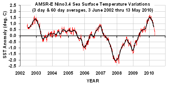
The most recent El Nino event is rapidly dying, as seen in the following plot of sea surface temperature (SST) variations averaged over the Nino3.4 region (5N to 5S, 120W to 170W) as measured by the AMSR-E instrument on NASA�s Aqua satellite during its period of record, 2 June 2002 through yesterday, 13 May 2010:

The 60-day cooling rate as of yesterday was the strongest seen yet in the 8 year period of record for the Nino3.4 region.
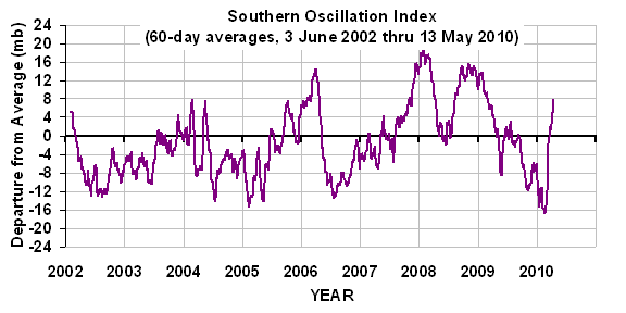
A similar plot of the Southern Oscillation Index (SOI) data, based upon the sea level air pressure difference between Tahiti and Darwin is consistent with the SST cooling, showing an increase in the pressure gradient across the tropical South Pacific, which portends increasing trade winds and cooling of the ocean surface:

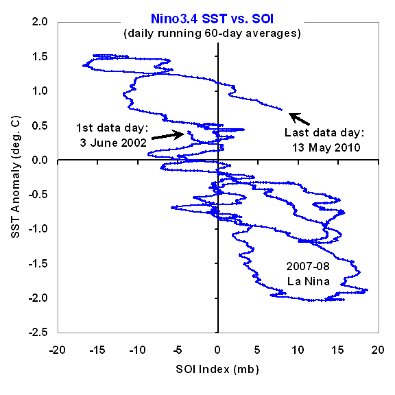
A plot of these two time series against one another (next plot) reveals that the most recent SSTs are unusually warm for the 60-day average SOI value:

There are at least three ways to interpret this excursion from the average relationship seen in the plot. One is that longer-term warming, whether natural or anthropogenic, has raised the temperature �baseline� about which the El Nino/La Nina events oscillate.
A second possibility is that we are in for continued rapid cooling in the Pacific as the SSTs fall to values more consistent with the SOI index.
A third is that the current excursion toward La Nina territory is going to reverse, and SOI values will decrease to more neutral conditions, while SSTs remain relatively high.
As is always the case, all we can do is sit back and watch.

 Home/Blog


