Archive for the ‘Blog Article’ Category

Drought Relief: Shasta Lake Rises 10 ft. in One Day

Friday, December 12th, 2014

The latest in a series of Pacific storms hit California yesterday with high winds and over 6 inches of rain at Shasta Dam. A number of mountain stations that feed the reservoirs in N. California, which are at very low levels from the continuing drought, have registered over 10 inches of rain in the last week.

With yesterday’s heavy rains, Lake Shasta rose a spectacular 10.6 feet in one day, which added over 130,000 acre feet of water volume to California’s largest reservoir. That’s enough water to fill 65,000 Olympic size swimming pools.

The following graph shows that there is still a long way to go to reach even normal water levels on Lake Shasta:
Lake-Shasta-storage-Dec-12-2014

Nevertheless, it also shows how the reservoir can recover in only one year, as it did from the 1976-77 dry period to the 1977-78 wet period, the result of rains from weak El Nino conditions.

The current El Nino conditions in the Pacific are contributing to the current wet and stormy period, which will need to continue before we can even begin to talk about the drought being over.

Greenpeace Desecrates Peru Archeological Sites

Thursday, December 11th, 2014

In yet another example of Greenpeace putting their ideology ahead of everything else, activists at the UN climate meeting in Lima, Peru have allegedly desecrated ancient holy Inca sites with banners, including the Nazca site. The actions are potentially criminal, as discussed in this video just released by CFACT.org.

CFACT executive director Craig Rucker, who narrates the above video, tells me the story is pretty big news in Peru right now.

UK Braces for 60 kt Winds, 50 ft Waves

Tuesday, December 9th, 2014

A strong low pressure “bomb” southeast of Greenland tracking eastward today will bring high winds and “phenomenal” waves to the west coast of the UK by Wednesday morning, with open-ocean winds exceeding 60 knots and wave heights as much as 50 feet or more.

The wave height field forecast for sunrise Wednesday shows what the Stornoway (Scotland) Coastguard is anticipating will be a “phenomenal” sea state (graphics courtesy of Weatherbell.com, click images for full-size):

Forecast wave height for Wednesday morning, Dec. 10, 2014.

Forecast wave height for Wednesday morning, Dec. 10, 2014.

The sea level pressure and wind patterns for the same time show the location of the low pressure and high near-surface winds:

Sea level pressure and near-surface wind speeds forecast for Wednesday morning, Dec. 10, 2014.

Sea level pressure and near-surface wind speeds forecast for Wednesday morning, Dec. 10, 2014.

Some schools near the northwest coasts have been closed tomorrow in anticipation of the storm.

4 Ft. of Ocean Effect Snow Hits Japan’s Main Island

Monday, December 8th, 2014

A cold Siberian air mass flowing across the Sea of Japan has caused up to 4 feet of snow on Japan’s main island of Honshu, killing 6 people, and over 1,000 people are trapped by boulders and fallen trees on roads.

Today’s NASA MODIS satellite image shows much of the northwestern side of Honshu covered by snow:
MODIS-Japan-snow-12-8-2014-enh

While Japan’s northernmost island of Hokkaido frequently experiences ocean-effect snow, heavy snow extending this far south is unusual on Honshu, with the current snowcover extending even a little south of the latitude of semi-tropical Tokyo. Another round of heavy ocean effect snow is expected late this week in the same areas.

2014 a Record Warm Year? Probably Not.

Thursday, December 4th, 2014

As continual fiddling with the global surface thermometer data leads to an ever-warmer present and an ever-cooler past, many of us are increasingly skeptical that beating a previous “warmest” year by hundredths of a degree has any real-world meaning. Yet, the current UN climate meeting in Lima, Peru, is setting the stage for some very real changes in energy policy that will inevitably make energy more expensive for everyone, no matter their economic status.

But there are some very good reasons to be skeptical of the claim that 2014 will be the “hottest year ever”…at the very least from the standpoint of it having any real impact on peoples’ lives.

No One Has Ever Felt “Global Warming”

If you turn up your thermostat by 1 deg. F, you might feel slightly warmer in the few minutes it takes for the warming to occur. But no one has felt the 1 deg. F rise in global average temperature in the last 50 to 100 years. It is too small to notice, when we are routinely experiencing day-night, day-to-day, and seasonal swings of tens of degrees.

The Urban Heat Island Effect Has Hopelessly Corrupted the Land Thermometer Data
Most thermometers measure temperature where people live, and people tend to build stuff that warms the local environment around the thermometer.

Called the urban heat island (UHI) effect, most of the warming occurs long before the thermometer site actually becomes “urban”. For instance, if you compare neighboring thermometers around the world, and also compare their population densities (as a rough indication of UHI influence), it can be easily demonstrated that substantial average UHI warming occurs even at low population densities, about ~1 deg. F at only 10 persons per sq. km!

This effect, which has been studied and published for many decades, has not been adequately addressed in the global temperature datasets, partly because there is no good way to apply it to individual thermometer sites.

2014 Won’t Be Statistically Different from 2010
For a “record” temperature to be statistically significant, it has to rise above its level of measurement error, of which there are many for thermometers: relating to changes in location, instrumentation, measurement times of day, inadequate coverage of the Earth, etc. Oh…and that pesky urban heat island effect.

A couple hundredths of a degree warmer than a previous year (which 2014 will likely be) should be considered a “tie”, not a record.

Our Best Technology, Satellites, Say 2014 Will Not be the Warmest

Our satellite estimates of global temperature, which have much more complete geographic coverage than thermometers, reveal that 2014 won’t be even close to a record warm year.

In fact, the satellite and thermometer technologies seem to be diverging in what they are telling us in recent years, with the thermometers continuing to warm, and the satellite temperatures essentially flat-lining.

So, why have world governments chosen to rely on surface thermometers, which were never designed for high accuracy, and yet ignore their own high-tech satellite network of calibrated sensors, especially when the satellites also agree with weather balloon data?

I will leave it to the reader to answer that one.

UAH Global Temperature Update for Nov. 2014: +0.33 deg. C

Tuesday, December 2nd, 2014

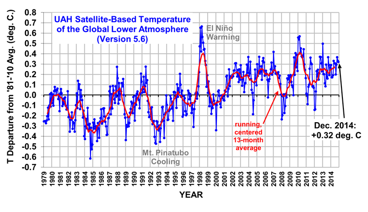
The Version 5.6 global average lower tropospheric temperature (LT) anomaly for November, 2014 is +0.33 deg. C, down a little from the October value of +0.37 deg. C (click for full size version):
UAH_LT_1979_thru_November_2014_v5

The global, hemispheric, and tropical LT anomalies from the 30-year (1981-2010) average for the last 23 months are:

YR MON GLOBAL NH SH TROPICS
2013 1 +0.497 +0.517 +0.478 +0.386
2013 2 +0.203 +0.372 +0.033 +0.195
2013 3 +0.200 +0.333 +0.067 +0.243
2013 4 +0.114 +0.128 +0.101 +0.165
2013 5 +0.082 +0.180 -0.015 +0.112
2013 6 +0.295 +0.335 +0.255 +0.220
2013 7 +0.173 +0.134 +0.211 +0.074
2013 8 +0.158 +0.111 +0.206 +0.009
2013 9 +0.365 +0.339 +0.390 +0.190
2013 10 +0.290 +0.331 +0.249 +0.031
2013 11 +0.193 +0.160 +0.226 +0.020
2013 12 +0.266 +0.272 +0.260 +0.057
2014 1 +0.291 +0.387 +0.194 -0.029
2014 2 +0.170 +0.320 +0.020 -0.103
2014 3 +0.170 +0.338 +0.002 -0.001
2014 4 +0.190 +0.358 +0.022 +0.092
2014 5 +0.326 +0.325 +0.328 +0.175
2014 6 +0.305 +0.315 +0.295 +0.510
2014 7 +0.304 +0.289 +0.319 +0.451
2014 8 +0.199 +0.244 +0.153 +0.061
2014 9 +0.294 +0.187 +0.401 +0.181
2014 10 +0.365 +0.333 +0.396 +0.189
2014 11 +0.329 +0.356 +0.302 +0.252

As I have mentioned before, month-to-month variations in global tropospheric temperature can be rather large just due to variations in convective overturning of the atmosphere (storm activity). To demonstrate how large the changes can be, the following plot shows the daily temperature anomalies for November, 2014. Note that the tropical troposphere warmed by 0.5 deg. C in less than 2 weeks, presumably coming out of a less convective phase.

LT-daily-variations-Nov-2014

Despite this rise in late November tropical temperatures, note the extratropics must have cooled since both the NH and SH show downward trends. While this variability in tropospheric temperature might suggest just how dynamic the climate system is, it requires less than 10% variability in storm activity. In general, rapid tropospheric warming events occur during SST cooling (and vice versa), which is much weaker in magnitude owing to the very different heat capacities of water versus air.

The global image for November should be available in the next day or so here.

Popular monthly data files (these might take a few days to update):

uahncdc_lt_5.6.txt (Lower Troposphere)
uahncdc_mt_5.6.txt (Mid-Troposphere)
uahncdc_ls_5.6.txt (Lower Stratosphere)

Frostweed Time Lapse, Take 2

Friday, November 28th, 2014

This is my second attempt at capturing a “frost flower” growing out of the frostweed plant (White Crownbeard).

I set up my camera and tripod at 1 a.m., the temperature was 29 deg., and the “flowers” had already started growing. I collected 5.5 hours of photos (1 per minute) which I made into this time lapse video, which is 1800 times faster than real time.

Click on the full-screen icon for the best viewing…the video is high-definition.

CA Drought Relief this Weekend

Wednesday, November 26th, 2014

Storm system approaching N. California on Nov. 25, 2014.

Storm system approaching California on Nov. 25, 2014.


A Pacific storm system continues its trek to California where it promises to bring 3 to 6 inches of much needed rain. The storm will stall and weaken just off-shore this weekend as another system from the Gulf of Alaska drops down and causes re-intensification. The result will be 3-5 days of on-and-off rains from Friday through Tuesday, with isolated areas possibly getting 9 inches or more (NCEP/WCP graphic courtesy of Weatherbell.com, click for full size):

6-day total rainfall forecast (Nov. 26 - Dec. 2) from the NCEP Weather Prediction Center.

6-day total rainfall forecast (Nov. 26 – Dec. 2) from the NCEP Weather Prediction Center.

Heavy rains are needed by reservoirs, currently at record-low levels, since light rains simply soak into the parched ground. While the storm will also bring 1-2 feet of welcome snowfall to the Sierra Nevada, the expected heavy rains are the most beneficial for filling reservoirs.

Major Storm to Bring Drought Relief to California

Monday, November 24th, 2014

Tuesday Morning (11/25) Update: It now looks like portions of Northern California could get as much as 5 to 10 inches of rainfall, with the Central Valley getting 1-2 inches or more. So I’m calling this a “major” storm now.

Late this week a vigorous Pacific storm system will track down the California coastline, bringing much needed rain to almost the entire state, and snow in the Sierra Nevada. The “Pineapple Express” system formed north of Hawaii, and will be joined up by another system sliding southward from the Gulf of Alaska.

It looks like at least half the state should get 1 inch 2 inches or more of rain, with 2+ feet of snow in the Sierra. Here’s the latest 8-day precipitation forecast from the GFS model (graphic from Weatherbell.com):

GFS model forecast total precipitation by Tuesday, Dec. 2, 2014 (12Z 11/25 model run time).

GFS model forecast total precipitation by Tuesday, Dec. 2, 2014 (12Z 11/25 model run time).

The rain will start in the northwest corner of the state on Friday (Nov. 28) as the Pacific low pressure approaches, and gradually spread south and east across the state through the weekend.

Hopefully this won’t just be a one-off event, but I suspect California will be glad to take whatever it can get. Here’s the latest weekly drought map, showing just how severe the drought has been over California.

A Snowy Thanksgiving for NYC?

Sunday, November 23rd, 2014

turkey-in-snow-smallIt is increasingly looking like New York City could have only its second white Thanksgiving in 75 years, the last being 25 years ago in 1989.

In fact, most of the major metropolitan areas along the I-95 corridor need to be watching the weather this week, especially if you have travel plans on Wednesday, which is when most of the snow is forecast to fall. It is still early, but the forecast models have been pretty consistent over the last couple days in forecasting this event.

After a new blast of cold air sweeps across the eastern U.S. early this week, an upper atmospheric disturbance just entering the Pacific Northwest today looks like it will phase up with a weak surface low pressure center in the southern Gulf of Mexico. The low will strengthen as it rapidly tracks up the coast, just offshore, with snow extending from portions of Georgia and the Carolinas northeastward to cover most coastal areas.

Several weather forecast model runs in a row now have been in general agreement, with the latest forecast snow amounts for the major metro areas being generally 4-6 inches or more (graphics from Weatherbell.com, updated from early morning Tuesday run):

GFS model forecast total snow accumulation by Thursday morning, Nov. 27, 2014 (early morning Tuesday model run)

GFS model forecast total snow accumulation by Thursday morning, Nov. 27, 2014 (early morning Tuesday model run)