A near-repeat of March’s “bomb cyclone” will bring up to 30 inches of snow this week to portions of Minnesota and South Dakota, with blizzard conditions and a threat of severe thunderstorms.
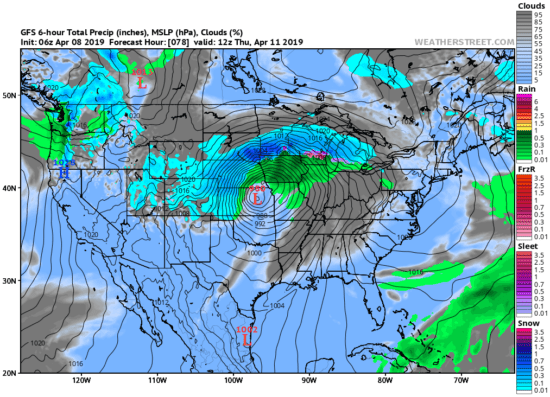
Roughly the same area that experienced flooding rains in March — and still trying to dry out enough to plant corn and soybeans — will see another round of heavy rain and heavy snow. The forecast location of the intense cyclone as of Thursday morning April 11 shows it taking a similar path to the record-setting March storm:

Forecast locations of strong low pressure and precipitation patterns Thursday morning, April 11, 2019 (Weatherstreet.com).
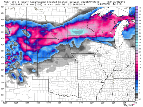
Forecast snowfall totals by midday Friday April 12 indicate the heaviest snowfall (up to 30 inches) over southern Minnesota, with 12-16 inches for Minneapolis:

Forecast total snowfall from the GFS model by midday Friday April 12 (graphic courtesy of Weatherbell.com).
The European ECMWF forecast model adds similarly heavy (~30 inches) snow totals in eastern South Dakota. Much of Wisconsin and northern Michigan are forecast to receive 6 to 12 inches.
The energy for such intense cyclones comes from the strong temperature contrast between two air masses. For example, by late Wednesday the temperatures in Nebraska will range from the 70s in the southeast to the 20s in the northwest, simultaneously feeding both blizzard conditions and a severe thunderstorm threat within the state.

 Home/Blog


