UAH Global Temperature Update for September, 2018: +0.14 deg. C

October 2nd, 2018

Globally, the coolest September in the last 10 years.

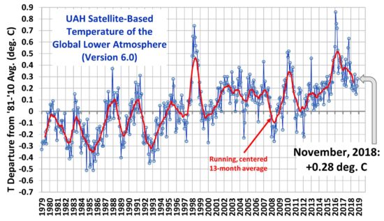
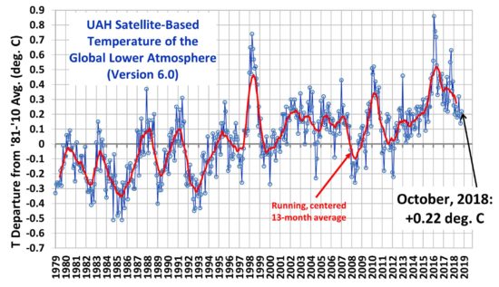
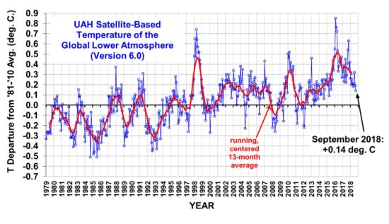
The Version 6.0 global average lower tropospheric temperature (LT) anomaly for September, 2018 was +0.14 deg. C, down a little from +0.19 deg. C in August:

Global area-averaged lower tropospheric temperature anomalies (departures from 30-year calendar monthly means, 1981-2010). The 13-month centered average is meant to give an indication of the lower frequency variations in the data; the choice of 13 months is somewhat arbitrary… an odd number of months allows centered plotting on months with no time lag between the two plotted time series. The inclusion of two of the same calendar months on the ends of the 13 month averaging period causes no issues with interpretation because the seasonal temperature cycle has been removed, and so has the distinction between calendar months.

This was the coolest September in the last 10 years in the global average.

Some regional LT departures from the 30-year (1981-2010) average for the last 21 months are:

YEAR MO GLOBE NHEM. SHEM. TROPIC USA48 ARCTIC AUST
2017 01 +0.33 +0.32 +0.34 +0.10 +0.28 +0.95 +1.22
2017 02 +0.39 +0.58 +0.20 +0.08 +2.16 +1.33 +0.21
2017 03 +0.23 +0.37 +0.09 +0.06 +1.21 +1.24 +0.98
2017 04 +0.28 +0.29 +0.26 +0.22 +0.90 +0.23 +0.40
2017 05 +0.45 +0.40 +0.49 +0.41 +0.11 +0.21 +0.06
2017 06 +0.22 +0.33 +0.10 +0.39 +0.51 +0.10 +0.34
2017 07 +0.29 +0.31 +0.28 +0.51 +0.61 -0.27 +1.03
2017 08 +0.41 +0.40 +0.42 +0.46 -0.54 +0.49 +0.78
2017 09 +0.54 +0.51 +0.57 +0.54 +0.29 +1.06 +0.60
2017 10 +0.63 +0.67 +0.59 +0.47 +1.21 +0.83 +0.86
2017 11 +0.36 +0.34 +0.38 +0.27 +1.35 +0.68 -0.12
2017 12 +0.42 +0.50 +0.33 +0.26 +0.45 +1.37 +0.36
2018 01 +0.26 +0.46 +0.06 -0.11 +0.59 +1.36 +0.42
2018 02 +0.20 +0.25 +0.16 +0.03 +0.92 +1.19 +0.18
2018 03 +0.25 +0.40 +0.10 +0.07 -0.32 -0.33 +0.59
2018 04 +0.21 +0.31 +0.11 -0.12 0.00 +1.02 +0.69
2018 05 +0.18 +0.41 -0.05 +0.03 +1.93 +0.18 -0.40
2018 06 +0.21 +0.38 +0.04 +0.12 +1.19 +0.83 -0.55
2018 07 +0.32 +0.42 +0.21 +0.29 +0.51 +0.29 +1.37
2018 08 +0.19 +0.21 +0.17 +0.12 +0.06 +0.09 +0.25
2018 09 +0.14 +0.15 +0.14 +0.24 +0.88 +0.21 +0.18

The linear temperature trend of the global average lower tropospheric temperature anomalies from January 1979 through September 2018 remains at +0.13 C/decade.

The UAH LT global anomaly image for September, 2018 should be available in the next few days here.

The new Version 6 files should also be updated at that time, and are located here:

Lower Troposphere: http://vortex.nsstc.uah.edu/data/msu/v6.0/tlt/uahncdc_lt_6.0.txt
Mid-Troposphere: http://vortex.nsstc.uah.edu/data/msu/v6.0/tmt/uahncdc_mt_6.0.txt
Tropopause: http://vortex.nsstc.uah.edu/data/msu/v6.0/ttp/uahncdc_tp_6.0.txt
Lower Stratosphere: http://vortex.nsstc.uah.edu/data/msu/v6.0/tls/uahncdc_ls_6.0.txt

My Tucker Carlson Interview Last Night, and Calling Out Bill Nye & James Hansen

September 15th, 2018

It didn’t last long, but I was interviewed in one segment on Tucker Carlson’s show of Fox News Channel last evening:

The subject was Hurricane Florence and whether it could be blamed on President Trump (specifically) or humanity (more generally).

You really can’t say much in only a couple of minutes, and it’s difficult when you don’t know what the questions will be. I got a plug in for Anthony Watts’ revealing the deception Bill Nye’s (The Science Guy) faked global-warming-in-a-jar experiment.

How did I get on Tucker’s show? It started when the folks at the Texas Public Policy Foundation asked me to write an op-ed to counter the global warming hype around Hurricane Florence. That was published in USA Today yesterday morning. They also set up several radio talk show interviews during the day, and scored the Tucker Carlson spot several hours before showtime.

I have to drive 2 hours to Nashville for national TV interviews, since our local TV affiliates have stopped honoring requests to handle the studio work here in Huntsville. If it’s a major show, the network pays for a makeup artist to come in and take a few years off my face.

I never get to see TV interview while we are doing them remotely. I have an earpiece and stare into a TV camera. It takes a few times to get used to having a conversation with a camera lens.

The more I think about Bill Nye’s experiment, the more irritated I get with the consensus scientific establishment for not telling Bill Nye that such an experiment cannot work; you cannot demonstrate the greenhouse effect on temperature with CO2 in a glass jar. Scientists who understand atmospheric radiative transfer know that.

The fact that the “Climate 101” video is still out there means the scientific establishment (plus Al Gore, who used it in his “Climate Reality Project”), are complicit in scientific fraud in order to advance the alarmist global warming narrative.

If their evidence for human-caused climate change is so good, they shouldn’t have to fake evidence to support their claims. I realize Bill Nye isn’t part of the climate research establishment, but he has a huge influence on public perception and scientific understanding. James Hansen also has had a huge influence on the public debate, and yet broke NASA rules by speaking to the press and Congress without management approval (and also likely violated the Hatch Act by campaigning politically..yes, he did, ThinkProgress, because he was a member of the Senior Executive Service, which has special Hatch Act rules.. I know because I was one of them, and I resigned NASA rather than have my hands tied).

This is the state of climate science today: if you support the alarmist narrative, you can exaggerate threats and connections with human activities, fake experiments, break government rules, intimidate scientific journal editors (and make them resign),and even violate the law.

As long as you can say you are doing it for the children.

U.S. Major Landfalling Hurricanes Down 50% Since the 1930s

September 14th, 2018

While the wind, storm surge, and freshwater flooding from Category 1 Hurricane Florence will no doubt cause massive damage, we should remember that – historically speaking – major landfalling hurricanes were more frequent in past decades.

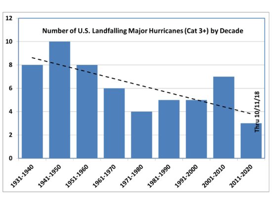
Contrary to popular perception, the number of major hurricanes making landfall in the U.S. has dropped by an average of more than 50% since the 1930s:

While you might object that the current decade isn’t over with yet, if we assume the long-term average of 6 storms per decade continues for the remaining 2.5 hurricane seasons, the downward trend since the 1930s will still be a 50% reduction.

Why did I pick the 1930s as the starting point?

Because yesterday I presented U.S. Government data on the 36 most costly hurricanes in U.S. history, which have all occurred since the 1930s. Since the 1930s, hurricane damages have increased dramatically. But, as Roger Pielke, Jr. has documented, that’s due to a huge increase in vulnerable infrastructure in a more populous and more prosperous nation.

It’s not due to stronger hurricanes hitting the U.S. or to global warming.

The 36 Costliest U.S. Hurricanes Have Not Increased in Intensity Over Time

September 12th, 2018

UPDATE: Includes all 36 most-destructive U.S. hurricanes in the U.S. Govt. report.

As part of the 2nd edition of my Kindle e-book Inevitable Disaster: Why Hurricanes Can’t Be Blamed On Global Warming, I include the following graph, based upon data in a January 2018 U.S. Government report.

In the top panel we see that the average monetary damages of the 36 most costly hurricane disasters in U.S history has gone up dramatically in recent decades.

But in the 2nd panel we see that the average intensity of those 36 most costly storms has not increased actually decreased..

Most recent (2018) U.S. Government analysis of the 36 most costly hurricane disasters in U.S. history, showing that increasing damages are due to increasing population density and infrastructure vulnerability, not due to storm intensity.

The increasing number of “damaging” storms in recent decades is, of course, an artifact of the increasing monetary damages with time: only the 36 most costly storms are included.

Of course, this is what Roger Pielke, Jr. has been saying for years.

If you are wondering about whether the number of ALL major hurricanes (whether causing major damage or not) have increased, here’s that plot. Even considering there’s still some time left in the current decade, I’d say there’s no statistically significant trend…and certainly a downward trend since the 1940s!:

My new Kindle book: Global Warming Skepticism for Busy People

September 12th, 2018

I sometimes get asked for a concise and accessible summary of my skeptical views on global warming. After a year or more of thinking and writing, my new Kindle book Global Warming Skepticism for Busy People is meant to fill that need.

As a bonus, I guarantee it will be easier to understand than Neil deGrasse Tyson’s Astrophysics for People in a Hurry.

At nearly 32,000 words with 40 high-res illustrations it’s more comprehensive than my previous Kindle books, but still readable in about 2-3 hours. The book is not meant to cover all of the skeptical views out there, but rather everything that I believe is most important to the global warming and energy policy debate. (If people convince me I’ve missed a couple of subjects that need to be addressed, it is easy and fast to update Kindle books.)

Maybe the best way to summarize what is in the book is to list the chapter titles:

Preface
1. Overview of the Reasons for Skepticism
2. The Five Big Questions
3. Skepticism versus Alarmism
4. The Unholy Alliance: Politics and Science
5. How Could 97% of Scientists Be Wrong?
6. What is the Greenhouse Effect?
7. What Causes Temperature Change?
8. The Good News about Increasing CO2
9. The U.N. IPCC Consensus: Government-Funded Biased Science
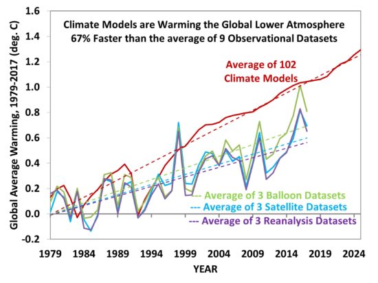
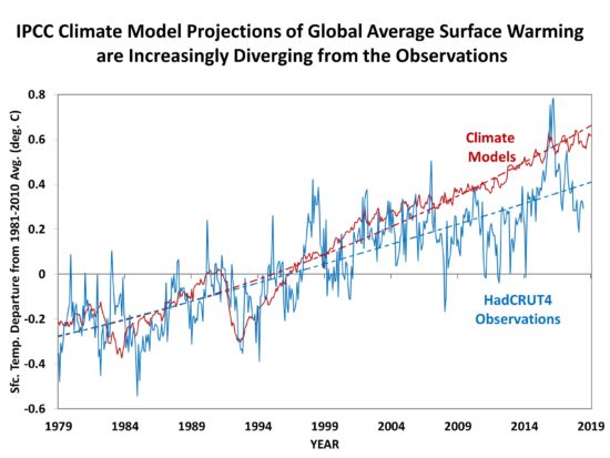
10. Climate Models Exaggerate Recent Warming
11. Warming since the 1800s Suggests Climate Models are Too Sensitive
12. How the Reliance on IPCC Climate Models Affects You
13. Why is Warming Not Progressing as Predicted?
14. Refuting Common Climate Delusions
Conclusions

That last chapter is where I refute the frequent media claims about worsening heatwaves, wildfires, droughts, floods, hurricanes, tornadoes, weather-related disaster losses, sea level rise, sea ice melt, ice sheet collapse, and ocean acidification.

I consider this my most complete treatment of the subject in one place, with my latest position on a variety of subjects. I have references to some of the latest findings and events of interest — as recent as September 3, 2018. I’ve included hyperlinks where appropriate so that readers can easily investigate my claims for themselves.

I hope you find it entertaining and informative. And, again, I am open to suggestions for material I might have missed… keeping in mind I am not aiming for the most exhaustive treatment of global warming skepticism, but the most effective one.
*******************************************************************************
ALSO: I have updated and expanded my Kindle book Inevitable Disaster: Why Hurricanes Can’t be Blamed on Global Warming, with new information and inclusion of Hurricane Florence. This 2nd Edition should go live tonight.

Hurricane Florence: Nature’s Business as Usual, Not Climate Change

September 10th, 2018

A potential new poster child for global warming ignores the lack of trend in major hurricane landfalls in the Carolinas.

GOES-East image of rapidly-strengthening Hurricane Florence, forecast to arrive on the coast of the Carolinas as a Cat 4 storm on Thursday night, Sept. 13, 2018.

Although it is still 3-4 days away, rapidly strengthening Hurricane Florence is increasing the threat of a major hurricane landfall somewhere within 120 miles or so of Wilmington, NC. If it reaches that area as a Cat 4 storm, the damage produced will be extensive, likely amounting to tens of billions of dollars.

By coincidence, the hurricane disaster (if it unfolds) will occur during this year’s Global Climate Action Summit (Sept. 12-14) in San Francisco, possibly the most star-studded climate alarmist extravaganza in existence, with climate experts such as Al Gore, Alec Baldwin, Andrea Mitchell, Catherine McKenna, Dave Matthews, Jane Goodall, John Kerry, and Tom Steyer.

As we all know, these are people who lead by example in their efforts to reduce their so-called carbon footprints.

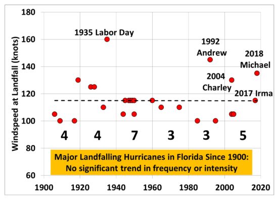
Attendees of the conference are almost guaranteed to point to Florence as an example of what we can expect more of with global warming. But it’s curious how there hasn’t been a statistically significant increase in major hurricane strikes in the Carolinas (based upon NHC data), even assuming Florence hits as a Cat3+:

(The same is true in Florida.)

The 1950s was the stand-out decade for major hurricane strikes in the Carolinas, with Hurricane Hazel in 1954 doing major damage, even as far north as Toronto. Hazel’s destruction of Myrtle Beach, SC led to a massive rebuilding effort that transformed that community forever.

For sure, there has been an increase in hurricane damages over time, as infrastructure along the U.S. Gulf and Atlantic coasts has increased dramatically. There is simply more stuff for Mother Nature to destroy. But I doubt that the luminaries attending the Global Climate Action Summit this week can understand that increasing damages would occur even without any climate change.

Major hurricanes are business as usual for nature, just uncommon.

For now, let’s hope Florence weakens or stays offshore. But as the above chart shows, the Carolinas should not be surprised if a disaster occurs, at least based upon the history of major hurricane strikes.

East Coast Nervous About Major Hurricane Florence

September 7th, 2018

We are now at the climatological peak of the Atlantic hurricane season, and Mother Nature is revving into high gear. We could have up to three hurricanes in the Atlantic in the coming days, as strong easterly waves continue to emerge from the west coast of Africa:

GOES-16 view of the North Atlantic, midday September 7, 2018.

Florence is of the most immediate concern. While still about 6 days away, a variety of weather forecast models are beginning to converge in their forecasts for Hurricane Florence to make landfall somewhere between the Carolinas and Delaware. The latest “spaghetti” plot compiled by the South Florida Water Management District shows the model forecast tracks to be clustering along the mid-Atlantic, with the latest (11 a.m. EDT) official NHC forecast represented by the heavy red line:

(The westward and northward tracks in the above plot can be ignored.) Florence has temporarily weakened to a strong tropical storm, but should become a hurricane again this weekend, and then a major hurricane (maximum sustained winds of 111 to 130 mph) on Monday or Tuesday.

The two most-watched forecast models are the European ECMWF and the NOAA GFS. Even though it is still too early to place much confidence in their forecasts 6 days out, to give some idea of how those models are treating Florence, here’s this morning’s GFS model bringing Florence inland in North Carolina Thursday morning with wind gusts to 120 mph (graphic courtesy of WeatherBell.com):

GFS model forecast of Hurricane Florence landfall on the North Carolina coast on Thursday, September 13. This forecast time is still 6 days away, and so likely has a substantial forecast errors.

The GFS then takes Florence up into central Virgina, with 6 to 12 inches of total rainfall mostly east of the track.

The most recent ECMWF model run from last night takes Florence well inland after making landfall near the border of North and South Carolina.

Consistent with the GFS model, Joe Bastardi at Weatherbell.com earlier today predicted the hurricane might track up the Shenandoah Valley, centered on a region already waterlogged from a wet summer, and produce large amounts of additional rainfall the area does not need.

What we know for sure is that large waves and strong rip currents will be a threat along the eastern seaboard this weekend.

Again, it is still too early to place much confidence in any specific forecast. But the trend toward an East Coast landfall is becoming worrisome, and so residents in hurricane-prone areas, especially in the mid-Atlantic states, should be watching the official forecasts from the National Hurricane Center over the next few days in case serious preparations become necessary.

UAH Global Temperature Update for August 2018: +0.19 deg. C

September 1st, 2018

The Version 6.0 global average lower tropospheric temperature (LT) anomaly for August, 2018 was +0.19 deg. C, down from the July value of +0.32 deg. C:

Global area-averaged lower tropospheric temperature anomalies (departures from 30-year calendar monthly means, 1981-2010). The 13-month centered average is meant to give an indication of the lower frequency variations in the data; the choice of 13 months is somewhat arbitrary… an odd number of months allows centered plotting on months with no time lag between the two plotted time series. The inclusion of two of the same calendar months on the ends of the 13 month averaging period causes no issues with interpretation because the seasonal temperature cycle has been removed, and so has the distinction between calendar months.

Some regional LT departures from the 30-year (1981-2010) average for the last 20 months are:

YEAR MO GLOBE NHEM. SHEM. TROPIC USA48 ARCTIC AUST
2017 01 +0.33 +0.32 +0.34 +0.10 +0.27 +0.95 +1.22
2017 02 +0.39 +0.58 +0.20 +0.08 +2.16 +1.33 +0.21
2017 03 +0.23 +0.37 +0.09 +0.06 +1.21 +1.24 +0.98
2017 04 +0.28 +0.29 +0.26 +0.21 +0.89 +0.23 +0.40
2017 05 +0.45 +0.40 +0.49 +0.41 +0.11 +0.21 +0.06
2017 06 +0.22 +0.33 +0.10 +0.39 +0.51 +0.10 +0.34
2017 07 +0.29 +0.30 +0.28 +0.51 +0.61 -0.27 +1.03
2017 08 +0.41 +0.40 +0.42 +0.46 -0.54 +0.49 +0.77
2017 09 +0.54 +0.51 +0.57 +0.54 +0.29 +1.06 +0.60
2017 10 +0.63 +0.67 +0.59 +0.47 +1.21 +0.83 +0.86
2017 11 +0.36 +0.34 +0.38 +0.27 +1.35 +0.68 -0.12
2017 12 +0.41 +0.50 +0.33 +0.26 +0.44 +1.37 +0.36
2018 01 +0.26 +0.46 +0.06 -0.11 +0.58 +1.36 +0.42
2018 02 +0.20 +0.25 +0.16 +0.03 +0.92 +1.19 +0.18
2018 03 +0.25 +0.40 +0.10 +0.07 -0.32 -0.33 +0.59
2018 04 +0.21 +0.31 +0.10 -0.12 -0.01 +1.02 +0.68
2018 05 +0.18 +0.41 -0.05 +0.03 +1.93 +0.18 -0.40
2018 06 +0.21 +0.38 +0.04 +0.12 +1.19 +0.83 -0.55
2018 07 +0.32 +0.42 +0.21 +0.29 +0.50 +0.29 +1.37
2018 08 +0.19 +0.21 +0.16 +0.12 +0.06 +0.09 +0.25

The linear temperature trend of the global average lower tropospheric temperature anomalies from January 1979 through August 2018 remains at +0.13 C/decade.

The UAH LT global anomaly image for August, 2018 should be available after Labor Day here.

The new Version 6 files should also be updated at that time, and are located here:

Lower Troposphere: http://vortex.nsstc.uah.edu/data/msu/v6.0/tlt/uahncdc_lt_6.0.txt
Mid-Troposphere: http://vortex.nsstc.uah.edu/data/msu/v6.0/tmt/uahncdc_mt_6.0.txt
Tropopause: http://vortex.nsstc.uah.edu/data/msu/v6.0/ttp/uahncdc_tp_6.0.txt
Lower Stratosphere: http://vortex.nsstc.uah.edu/data/msu/v6.0/tls/uahncdc_ls_6.0.txt

Green Energy Scam #167: Traffic-Driven Wind Turbines

August 21st, 2018

A YouTube video making the rounds on social media (with over 27 million views!) describes a system of small wind turbines placed in the median between two lanes of traffic. The wind generated by the traffic spins the turbine blades and generates (a very small amount of) electricity:

https://www.facebook.com/InTheKnowWanderlustByAOL/videos/463043554144777/

The question is, does such a system recapture energy that would have been lost anyway?

The answer is NO.

When the blades turn to generate electricity, they are slowing the wind generated by the moving traffic. That creates additional wind resistance, which increases aerodynamic drag on the cars, and reduces their gas mileage. In effect, the turbines are stealing energy from the cars and converting it to electricity.

No, it’s not like regenerative breaking in hybrid cars, nor is it like turbochargers. It’s forcing the car to do more work than it would have otherwise done… and inefficiently converting that extra work into another form of energy. Wouldn’t the cars have lost energy through aerodynamic drag anyway? Yes! But this system INCREASES the drag on the cars. It would be like putting a little wind turbine on the roof of the car and generating electricity that way. The electrical energy created would not be worth the gas you wasted to do it (unless you really needed the electricity…but that’s what car alternators are for, and they don’t run all the time anyway).

I’m pretty sure the system would waste energy, not save energy. That’s why I’m calling it a “scam”.

Here’s a short discussion by some engineers who come to the same conclusion.

Perseid meteor shower peaks tonight

August 12th, 2018

Update: The NASA Fireball Network, monitoring only a few U.S. locations, logged 56 Perseid fireballs last night.

The best meteor shower of the year — the Perseids — peaks tonight. In preparation for a planned outing to a dark sky site, I ran my camera from our roof last night for 8 hours. Despite significant light pollution, I made the following captures. The first was only 1 hour after sunset, and is an “Earthgrazer”, when the radiant is still below the horizon and meteors skim the upper atmosphere with long tails:

Perseid “Earthgrazer”, taken with Canon 6D, 15 sec exp., 20mm f/2.8, ISO3200. No cropping.

While one might suspect this was a satellite, the angular extent of the path is 60 deg., and in only 15 sec satellites cover only a small fraction of that distance; plus, the green color indicates a meteor. Also, the NASA fireball network picked this one up (one of the sensors is close to my house).

The second photo is after the radiant is well above the horizon, so the meteors have shorter paths directly into the upper atmosphere:

As in the previous photo, but with 100% crop, and taken about 2 a.m.

Given that the NASA Fireball Network logged 56 fireballs last night, I’m hopeful for tonight’s display, which should be approximately twice as productive. You can watch in any part of the sky starting after dark. The long trail meteors will be earlier in the evening, then increase in number through the night but have shorter tails. If you have a choice of directions to look, I would suggest directly overhead (use a reclining lawn chair to save your neck), or generally north-eastward as a second choice. But meteors can occur in any part of the sky.

Hoping for mostly clear skies tonight.