Here is the article I was referring to in today’s post, Whose Supported Policies Kill More People: ISIS…or Greenpeace? It is by Dr. Patrick Moore.
Greenpeace has made itself the sworn enemy of all life on Earth
By Patrick Moore, a founder of Greenpeace
Greenpeace, in furtherance of what is in effect its war against every species on the planet, has now turned to what, on the face of things, looks to me like outright breach of the RICO, wire-fraud, witness-tampering and obstruction-of-committee statutes. I have called in the FBI.
Greenpeace appears to have subjected Dr. Will Happer, Cyrus Fogg Brackett Professor of Physics at Princeton University, to a maladroit attempt at entrapment that has badly backfired on it.

Greenpeace used this dismal rent-by-the-hour office block in the Beirut souk for its entrapment scam.
The organization I founded has become a monster. When I was a member of its central committee in the early days, we campaigned � usually with success � on genuine environmental issues such as atmospheric nuclear tests, whaling and seal-clubbing.
When Greenpeace turned anti-science by campaigning against chlorine (imagine the sheer stupidity of campaigning against one of the elements in the periodic table), I decided that it had lost its purpose and that, having achieved its original objectives, had turned to extremism to try to justify its continued existence.
Now Greenpeace has knowingly made itself the sworn enemy of all life on Earth. By opposing capitalism, it stands against the one system of economics that has been most successful in regulating and restoring the environment.
By opposing the use of DDT inside the homes of children exposed to the anopheles mosquito that carries malaria, Greenpeace contributed to the deaths of 40 million people and counting, most of them children. It now pretends it did not oppose DDT, but the record shows otherwise. On this as on so many issues, it got the science wrong. It has the deaths of those children on what passes for its conscience.
By opposing fossil-fueled power, it not only contributes to the deaths of many tens of millions every year because they are among the 1.2 billion to whom its campaigns deny affordable, reliable, clean, continuous, low-tech, base-load, fossil-fueled electrical power: it also denies to all trees and plants on Earth the food they need.
Paradoxically, an organization that calls itself �Green� is against the harmless, beneficial, natural trace gas that nourishes and sustains all green things. Greenpeace is against greenery. Bizarrely, it is opposed to returning to the atmosphere a tiny fraction of the CO2 that was once present there.
In November 2015, out of the blue, Professor Happer received an email from �Hamilton Ellis�, a soi-disant �business consultancy� operating out of rent-by-the-hour offices in a crumbling concrete block in the Beirut souk.
The bucket-shop �consultancy�s� email said that a �client�, an energy and power company �concerned about the impacts of the UN climate talks�, wanted to commission Professor Happer to prepare a �briefing� to be released early in 2016 �which highlights the crucial role that oil and gas have to play in the developing economies, such as our client�s Middle East and North Africa region�.
The email smarmed on: �Given your influential work in this area and your position at Princeton we believe a very short paper authored or endorsed by yourself could work strongly in our client�s favour. Does this sound like a project you would be interested in discussing further?�
Will Happer replied enclosing a white paper written, with major input from him, by the CO2 Coalition, a new group that he had helped to establish earlier in 2015. He also sent a copy of testimony on the �social cost of carbon� that he had given at a regulatory hearing in St Paul, Minnesota. Crucially, he added: �I would be glad to try to help if my views, outlined in the attachments, are in line with those of your client.�
In short, he was not prepared to be bought. He would help the �client� of the �business consultancy� if and only if he was not asked to attest to anything that he did not already believe.
The �consultancy� replied: �It certainly sounds like you and our client are on the same page.� It went on to ask whether Professor Happer�s two papers had been �part of the same initiative on CO2 reported on [by Matt Ridley] in the London Times recently, and added: �The focus we envisage for this project comes from a slightly different angle. Our client wants to commission a short briefing paper that examines the benefits of fossil fuels to developing economies, as opposed to a switch to so-called clean energy.�
The �consultancy� also wanted to know whether it �would be able to reference you as Cyrus Fogg Brackett Professor of Physics at Princeton University if this project were to go ahead?�
It also tried to smoke out the identity of Professor Happer�s contacts in the U.S. media, and ended with a classical entrapment line: �It would be useful to know, in your experience, whether you would need to declare the source funding when publishing research of this kind�.
Professor Happer said: �The article � mentions Patrick Moore, like me a member of the CO2 Coalition, and my friend from Princeton, Freeman Dyson, who shares our views.�
He confirmed that his official title is Cyrus Fogg Brackett Professor of Physics, Emeritus. He also reinforced his earlier message indicating he could not be bought by stating, very clearly:
�To be sure your client is not misled on my views, it is clear there are real pollutants associated with the combustion of fossil fuels, oxides of sulfur and nitrogen for most of them, fly ash and heavy metals for coal, volatile organics for gasoline, etc. I fully support regulations for cost-effective control of these real pollutants. But the Paris climate talks are based on the premise that CO2 itself is a pollutant. This is completely false. More CO2 will benefit the world. The only way to limit CO2 would be to stop using fossil fuels, which I think would be a profoundly immoral and irrational policy.�
Professor Happer added that he no longer had external funding following his retirement, and went on: �My activities to push back against climate extremism are a labor of love, to defend the cherished ideals of science that have been so corrupted by the climate-change cult. If your client was considering reimbursing me for writing something, I would ask that whatever fee would have come to me would go directly to the CO2 Coalition. This was the arrangement I had with the attorneys representing the Peabody Coal Company in the regulatory hearings in Minnesota. The fee I would have received was sent instead to the CO2 Coalition, a 501(c)(3) tax exempt educational organization. The CO2 Coalition covers occasional travel expenses for me, but pays me no other fees or salary.�
The �consultancy� replied that the �client� was �completely comfortable with your views on fossil-fuel pollution�. It asked whether Matt Ridley might �help to disseminate our research when it is ready�, and whether the briefing could be peer-reviewed. �On the matter of reimbursement, we would of course remunerate you for your work and would be more than happy to pay the fee to the CO2 Coalition.�
Then another classic entrapment line: �Our client does not want their name associated with the research as they believe it will give the work more credibility. What provisions does the CO2 Coalition provide? Would this be an issue?�
Professor Happer replied that he was sure Matt Ridley would be interested in the briefing and that Breitbart would be among blogs and syndicated columnists that could also be interested.
As for peer review, he explained that �this normally refers to original work submitted to a scientific journal for publication, and not to the sort of articles that Ridley writes for the media, or what I think you are seeking to have written. If you like, I could submit the article to a peer-reviewed journal, but that might greatly delay publication and might require such major changes in response to referees and to the journal editor that the article would no longer make the case that CO2 is a benefit, not a pollutant, as strongly as I would like, and presumably as strongly your client would also like.�
He said his fees were $250 per hour, and that his Minnesota testimony had required four eight-hour days, so that the total cost was $8000. He said that, if he wrote the paper alone, he did not think there would be any problem stating that �The author received no financial compensation for this essay�. He added that he was pretty sure that the �client’s� donation to the CO2 Coalition would not need to be public according to US regulations of 503(c)(3) educational organizations, but that he could get some legal advice to confirm this if asked.
The �consultancy� replied: �The hourly rate works for us and, as previously discussed, we are happy to make a direct donation to the CO2 Coalition, providing it is anonymous. We can look into the official disclosure regulations, but it would be useful to know whether the CO2 Coalition voluntarily discloses its funders? Presumably there are other donors in a similar position to us?�
They added: �With regards to peer review, I raised this issue because Matt Ridley�s article on Dr Indur Goklany�s recent CO2 report said that it had been thoroughly peer reviewed. Would it be possible to ask the same journal to peer review our paper given that it has a similar thrust to Goklany�s? It�s not a deal-breaker, but I felt that it helped strengthen that piece of work.�
Professor Happer replied that early drafts of Goklany�s paper had been reviewed by him and by many other scientists; that he had suggested changes to which the author had responded; and that, although some members of the academic advisory board of the Global Warming Policy Foundation might have been too busy to respond to a request to comment on the first draft, �The review of Golkany�s paper was even more rigorous than the peer review for most journals�. Professor Happer said he would be glad to ask for a similar review for the first drafts of anything he wrote for the �client�.
He said he would double-check on the regulations, but did not think the CO2 Coalition, a 501(3)c tax-exempt educational organization, was required to make public any donors, except in Internal Revenue Service returns.
He checked with the CO2 Coalition, which replied that the Coalition was not obliged to identify any donors, except to the IRS, who would redact the list of donors if it received a request for the Coalition�s form 990.
On December 7 he received an email from one Maeve McClenaghan of Greenpeace, telling him that they had conducted what she grandiosely described as an �undercover investigation� � actually a criminal entrapment scam contrary to the RICO and wire-fraud statutes, and a flagrant attempt both to tamper with a Congressional witness (he is due to testify today, 8 December) and to obstruct committee proceedings � and that they intended to publish a �news article � regarding the funding of climate sceptic science.
She said: �Our article explores how fossil fuel companies are able to pay academics to produce research which is of benefit to them� and added that the story would be published on a Greenpeace website and �promoted widely� in the media. She gave Professor Happer only hours to respond.
Many of the points she said she proposed to include in the article were crafted in such a way as to distort what the above correspondence makes plain were wholly innocent and honest statements, so as to make them sound sinister. The libels Ms McClenaghan proposed to circulate will not be circulated here.
I shall, however pass on a comment made to me by Professor Happer: �I was suspicious about the email exchange from the start, so I wrote every response assuming that it might be public someday. But what I wrote expressed exactly what I believed to be true.�
That is the comment of one of the most transparently honest scientific colleagues I am honoured to know. I am, therefore, profoundly dismayed that the organization I founded � an organization that once did good work addressing real environmental concerns � has descended to what I consider to be criminality and now also proposes to descend to libel.
Accordingly, I have decided to inform the Federal Bureau of Investigation of Greenpeace�s dishonest and disfiguring attempt at entrapment of Professor Happer, whom I know to be a first-rate scientist, colleague and friend, one of the world�s half-dozen most eminent and experienced physicists, and one who would never provide any scientific advice unless in his professional opinion that advice was correct.
The organization�s timing was clearly intended to spring the trap on Professor Happer hours before he was due to appear in front of Congress. This misconduct constitutes a serious � and on many counts criminal � interference with the democratic process that America cherishes.
I have reported Greenpeace to the FBI under 18 USC 96 (RICO statute); 18 USC 1343 (wire fraud); 18 USC 1512 (attempting to intimidate a witness due to appear at a Congressional hearing); and 18 USC 1505 (obstruction of proceedings before committees).
I shall also be asking the Bureau to investigate Greenpeace�s sources of funding. It is now an enemy of the State, an enemy of humanity and, indeed, an enemy of all species on Earth.

 Home/Blog
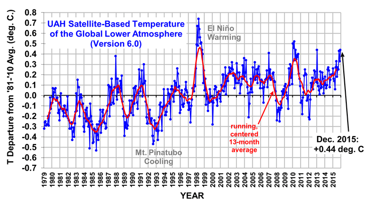


 As reported yesterday, an enterprising fellow actually got college students to

 Al Gore is the gift that just keeps on giving.