Lake Superior Ice Cover Well Ahead of 2014

February 22nd, 2015

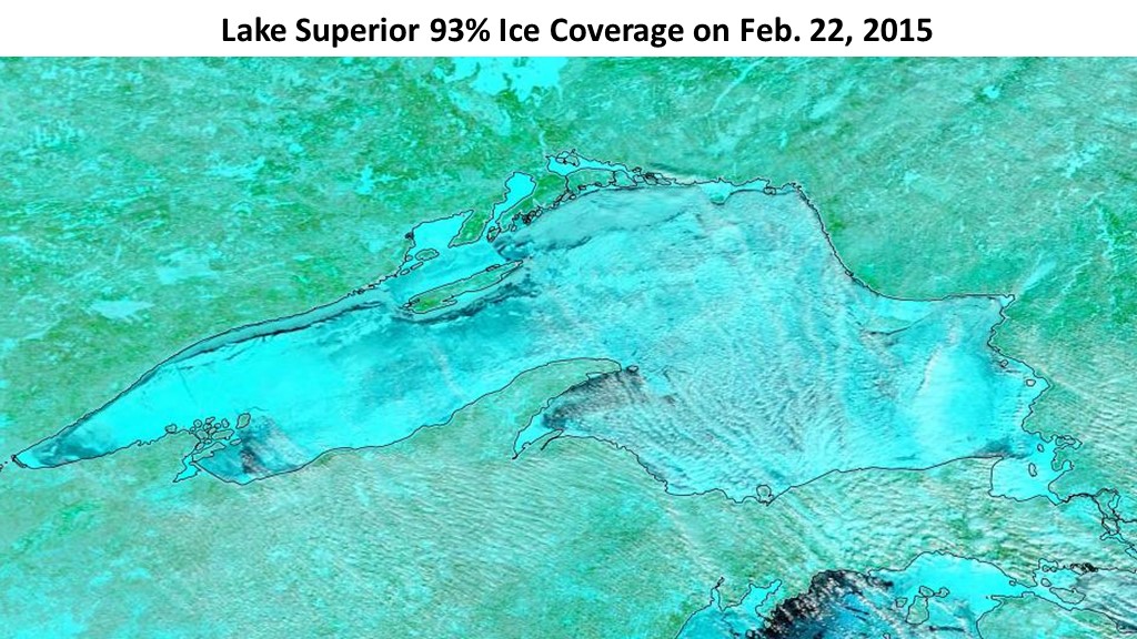
Remember the amazing ice cover of last year on Lake Superior? Well, the coverage today stands at 93%, while last year on this date it was ‘only’ 82%.

Exactly one year before that is was (believe it or not) only 15%. Go figure.

Here’s today’s color enhanced satellite image, where blue is either ice or snow on ice:

MODIS-Superior-ice-2-22-2015

The frigid weather and above normal ice cover is being blamed on global warming (of course). What would we do without Bill Nye to mislead us?

So, any guesses what will be blamed when we get a couple of warm winters and below-normal ice cover?

Hmmm?

Sometimes it’s good to remind people that weather — at least outside the tropics — is almost never “normal”.

Great Lakes Rapidly Freezing Over

February 19th, 2015

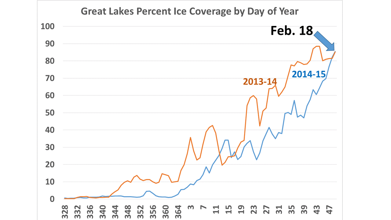
The recent frigid weather has led to a rapid freezing cycle on the Great Lakes, with ice cover increasing by another 20% in the last 10 days, which makes it now equal to last year’s epic coverage by this date (Great Lakes ice data available at GLERL):

great-lakes-ice-cover-graph

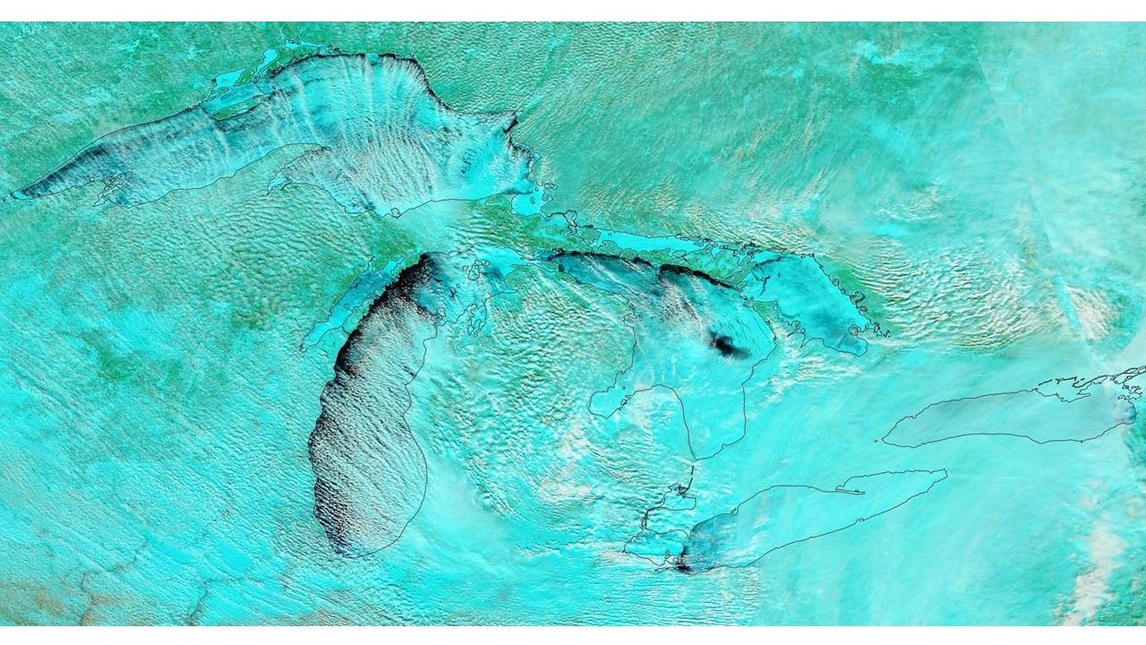
Here’s the latest MODIS false-color satellite image of the Great Lakes from yesterday, Feb. 18, 2015:
MODIS-Great-Lakes-7-2-1-Feb-18-2015

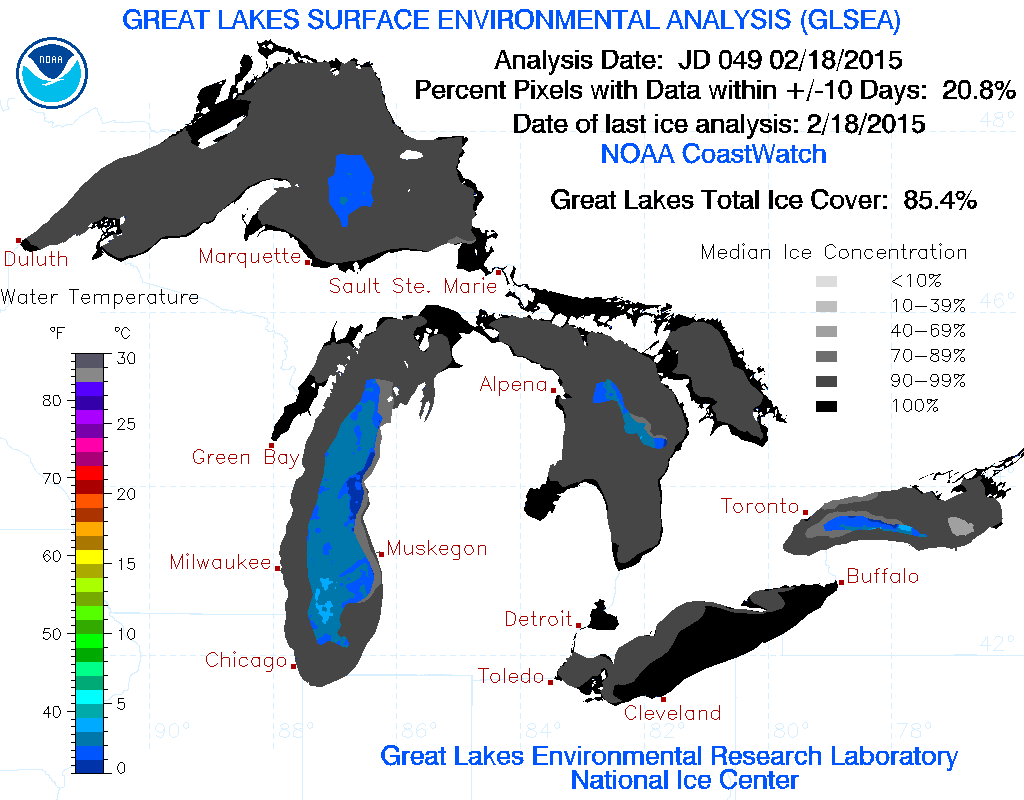
And here’s the official GLERL ice cover analysis for yesterday, which gives current coverage at 85.4%:
glsea_cur

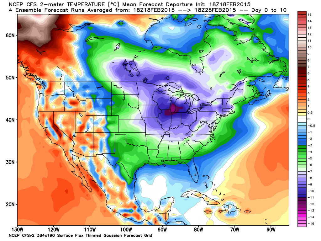
As the following graphic shows, the forecast temperatures for the next 10 days over the Great Lakes will be running an average of 15-20 deg. F below normal, so we could be looking at another record-setting ice cover season (graphic courtesy of Weatherbell.com):
cfs_anom_t2m_conus_2015021818_x41

What to call a NYT reporter of climate science?

February 13th, 2015

Justin-Gillis-Richard-Lindzen
The title of Justin Gillis’ recent NYT article is an excellent tip-off of how bad environmental reporting has gotten:

What to Call a Doubter of Climate Change?

Now, as a skeptical PhD climate scientist who has been working and publishing in the climate field for over a quarter century, I can tell you I don’t know of any other skeptics who even “doubt climate change”.

The mere existence of climate change says nothing about causation. The climate system is always changing, and always will change. Most skeptics believe humans have at least some small role in that change, but tend to believe it might well be more natural than SUV-caused.

So, the title of the NYT article immediately betrays a bias in reporting which has become all too common. “He who frames the question wins the debate.”

What we skeptics are skeptical about is that the science has demonstrated with any level of certainty: (1) how much of recent warming has been manmade versus natural, or (2) whether any observed change in storms/droughts/floods is outside the realm of natural variability, that is, whether it too can be blamed on human activities.

But reporters routinely try to reframe the debate, telling us skeptics what we believe. Actually reporting in an accurate manner what we really believe does not suit their purpose. So (for example) Mr. Gillis did not use any quotes from Dr. John Christy in the above article, even though he was interviewed.

Mr. Gillis instead seems intent on making a story out of whether skeptical climate scientists should be even afforded the dignity of being called a “skeptic”, when what we really should be called is “deniers”.

You know — as evil as those who deny the Holocaust. (Yeah, we get the implication.)

He then goes on to malign the scientific character of Dr. Richard Lindzen (a Jew who is not entirely pleased with misplaced Holocaust imagery) because the majority of scientific opinion runs contrary to Dr. Lindzen, who is also a member of the prestigious National Academy of Sciences.

Do I need to remind Mr. Gillis that the cause(s) of climate change are much more difficult to establish than, say, the cause of stomach ulcers? There is only one climate system (patient) to study, but many millions of ulcer sufferers walking around.

And yet the medical research community was almost unanimous in their years of condemnation of Marshall and Warren, two Australian researchers who finally received the 2005 Nobel Prize in medicine for establishing the bacterial basis for peptic ulcers, one of the most common diseases in the world.

Does Mr. Gillis really want to be a journalist? Or just impress his NYC friends?

The idea that the causes of climate change are now just as well established as gravity or the non-flatness of the Earth (or that ulcers are caused by too much stress and spicy food, too?) is so ridiculous that only young school children could be indoctrinated with such silly tripe.

Which, I fear, is just what is happening.

Winters in Boston Becoming Drier

February 12th, 2015

Much has been said in recent weeks about how bigger snowstorms in Boston are (supposedly) just what climate models have predicted. “Global warming” is putting more water vapor into the air, leading to more “fuel” for winter storms and more winter precipitation.

While this general trend is seen in climate models for global average conditions (warming leads to more precipitation), what do the models really predict for Boston?

And what has actually been observed in Boston?

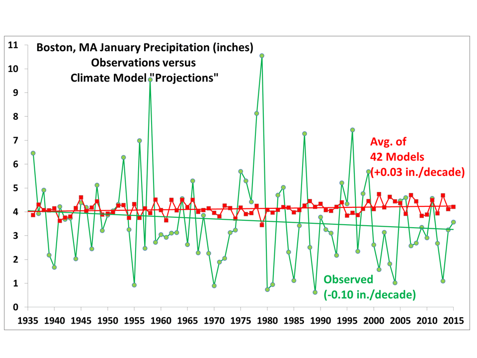
The following plot shows that the observed total January precipitation in Boston has actually decreased since the 1930’s, contrary to the average “projections” (in reality, hindcasts) from a total of 42 climate models, at the closest model gridpoint to Boston:

Fig. 1. January total precipitation at Boston, 1936 to 2015, in observations versus the average of 42 climate models.  A small bias in the model precip is removed so the linear trends start at the same point early in the record.

Fig. 1. January total precipitation at Boston, 1936 to 2015, in observations versus the average of 42 climate models. A small bias in the model precip is removed so the linear trends start at the same point early in the record.

Note that even the forecast increase in January precipitation is so small that it probably would never be noticed if it actually occurred.

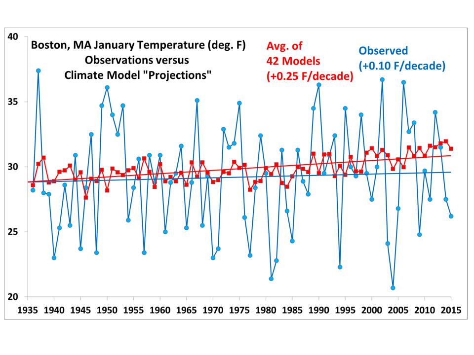
During the same period, January temperatures in Boston have seen a statistically insignificant +0.1 deg. F per decade warming, in contrast to 2.5 times faster average warming produced by the 42 climate models:

Fig. 2. As in Fig. 1., but for temperature.

Fig. 2. As in Fig. 1., but for temperature.

What is very evident is the huge amount of natural variability from year to year, as Bostonians are well aware.

It’s just weather, folks. Blaming everything on “climate change” is just plain lazy.

Rare Pacific Typhoon Forms in mid-February

February 10th, 2015

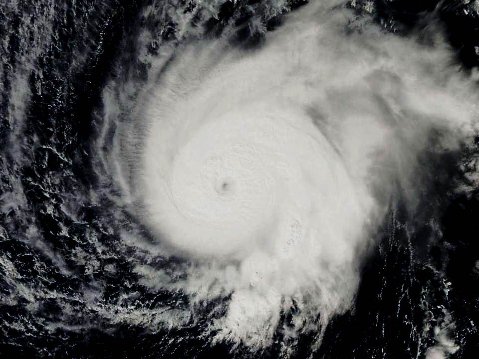
Pacific Typhoon Higos has formed in the tropical West Pacific. What makes this storm unusual is that it has formed at the least likely time of year, climatologically speaking.

Rare Typhoon Higos viewed by the NASA MODIS imager on Feb. 10, 2015.

Rare Typhoon Higos viewed by the NASA MODIS imager on Feb. 10, 2015.

North Pacific typhoons have formed in all calendar months, but a Japanese analysis of the dates they form suggests that Feb. 11 is the least likely date. This date can be considered the beginning (or end) of the typhoon season.

So, Typhoon Higos might be considered the latest north Pacific typhoon on record. Or maybe it’s the earliest (there was a Feb. 15, 1965 typhoon that had been considered the earliest). It all depends upon when you decide the start/end date of typhoon season is.

One thing for sure is that a typhoon in mid-February is rare, indeed. According to this historical list going back 65 years, no typhoons have ever formed during the week of 8-14 February.

Runnin’ Back to Saskatoon: One Cold Weekend Ahead for the East

February 9th, 2015

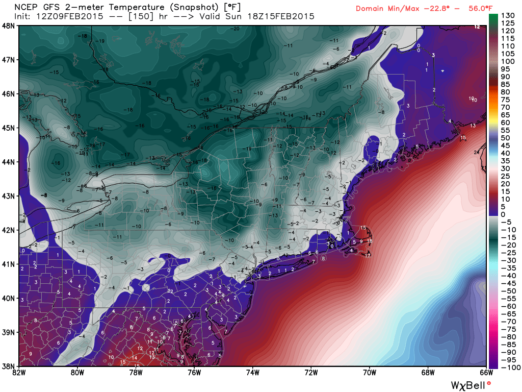
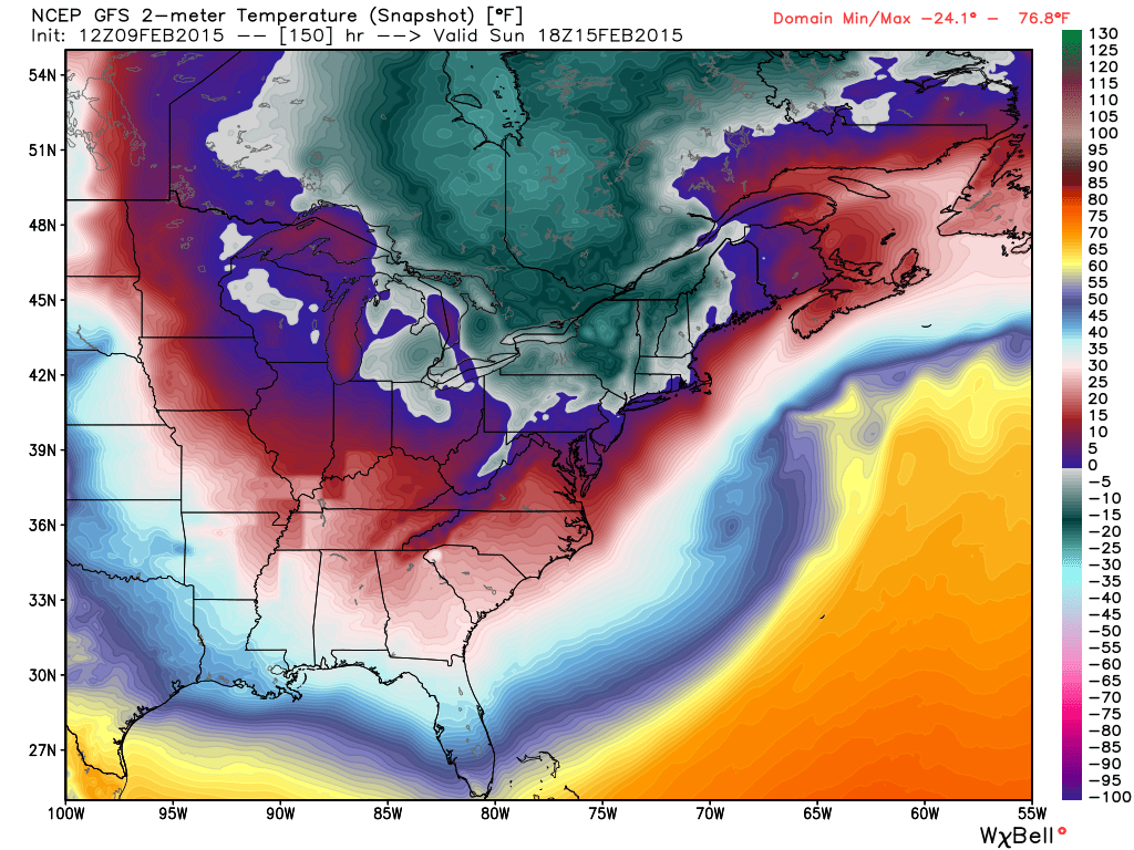
If you are in Saskatchewan and thinking of going to Disney World to warm up this weekend, you might want to be Runnin’ Back to Saskatoon, because by Sunday morning it might well be colder in Orlando than it will be in Saskatoon.

A series of Arctic cold fronts plunging down out of Canada will cause record-breaking cold across the eastern U.S. over the weekend. As the following map shows, most of New York state might not even get above 0 deg. F on Sunday (all graphics courtesy of Weatherbell.com, click for full-size):

GFS model temperature forecast for midday Sunday, Feb. 15, 2015.

GFS model temperature forecast for midday Sunday, Feb. 15, 2015.

If we zoom out, we see that much of the East won’t even get above freezing on Sunday:
gfs_t2m_b_east2_26

What will make matters even worse is that winds will be gusting over 30 mph in New England, producing wind chills of 30 below zero during the day on Sunday.

Funky Clouds off California Coast Yesterday

February 4th, 2015

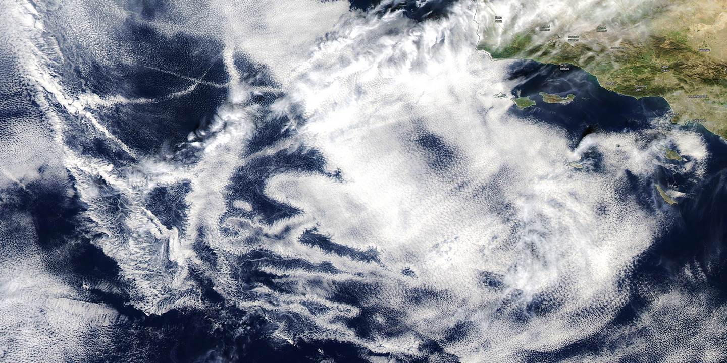
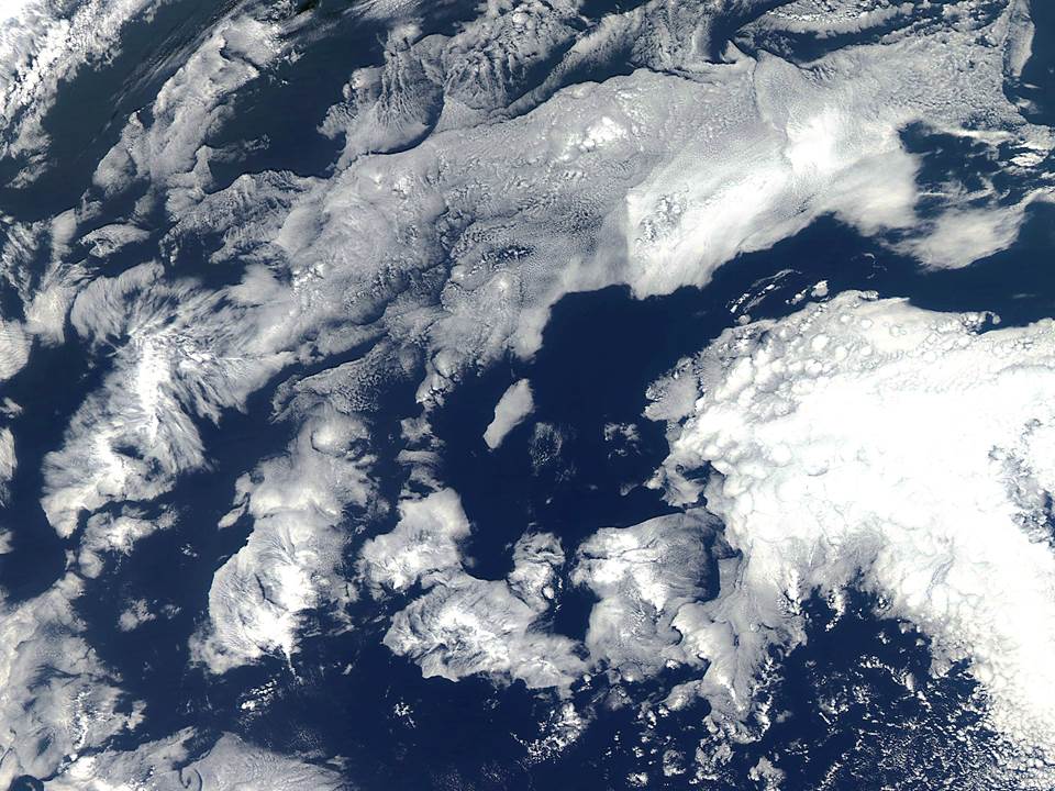
Almost every day I check out NASA’s Worldview website to look at global color satellite imagery from the MODIS instruments. I’m usually watching weather systems. If nothing else, the imagery is beautiful.

Yesterday, there were some particularly funky looking marine stratus clouds off the coast of California, generally west and southwest of Los Angeles. There are a couple of ship tracks evident, but I think most of the fractal-esque structure is natural (click image for full-size):

MODIS-Aqua-2-3-2015-CA-marine-stratus

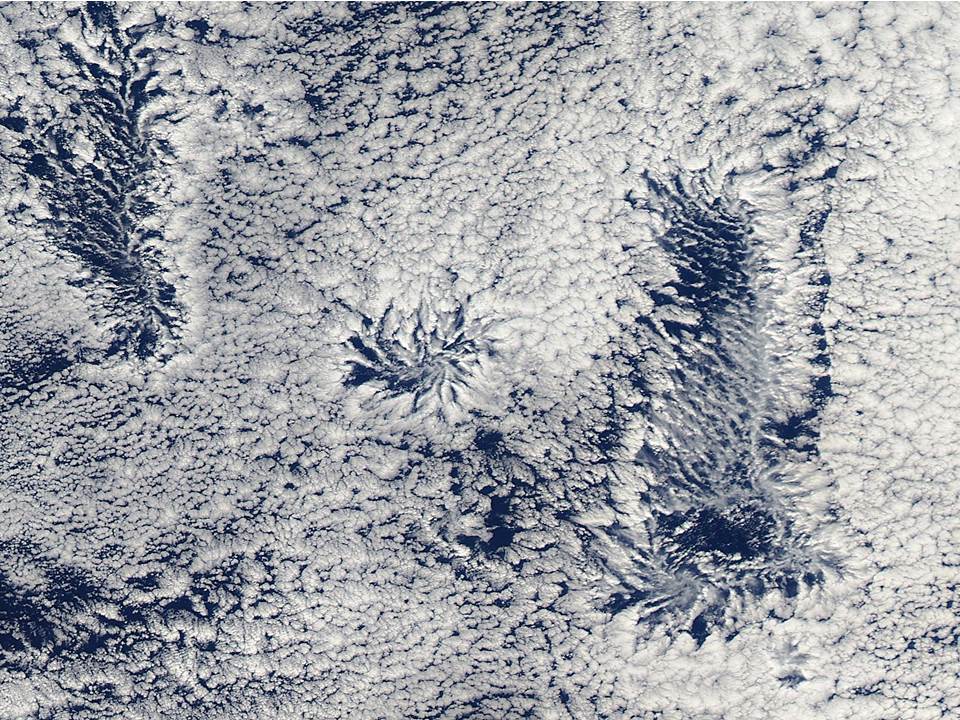
Marine stratus clouds form under a strong temperature inversion at the base of deep sinking air layers associated with high pressure zones, and they take on a wide variety of fascinating forms.

Here’s another example from well off the California coast on Dec. 23, 2014:

MODIS-Aqua-12-23-2014-CA-marine-stratus

And yet another from Dec. 21, 2014:

MODIS-Aqua-12-21-2014-CA-marine-stratus

UAH Global Temperature Update for Jan. 2015: +0.35 deg. C

February 3rd, 2015

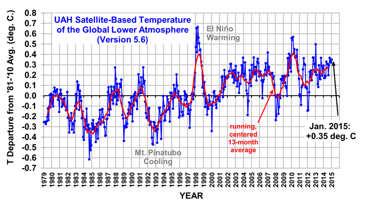
The Version 5.6 global average lower tropospheric temperature (LT) anomaly for January, 2015 is +0.35 deg. C, little changed from the December 2014 value of +0.32 deg. C (click for full size version):
UAH_LT_1979_thru_January_2015_v5

The global, hemispheric, and tropical LT anomalies from the 30-year (1981-2010) average for the last 13 months are:

YR MON GLOBAL NH SH TROPICS
2014 01 +0.291 +0.387 +0.194 -0.029
2014 02 +0.170 +0.320 +0.020 -0.103
2014 03 +0.170 +0.338 +0.002 -0.001
2014 04 +0.190 +0.358 +0.022 +0.092
2014 05 +0.326 +0.325 +0.328 +0.175
2014 06 +0.305 +0.315 +0.295 +0.510
2014 07 +0.304 +0.289 +0.319 +0.451
2014 08 +0.199 +0.244 +0.153 +0.061
2014 09 +0.294 +0.187 +0.401 +0.181
2014 10 +0.365 +0.333 +0.396 +0.189
2014 11 +0.329 +0.354 +0.303 +0.247
2014 12 +0.322 +0.465 +0.178 +0.296
2015 01 +0.351 +0.551 +0.152 +0.126

The global image for January, 2015 should be available in the next day or so here.

Popular monthly data files (these might take a few days to update):

uahncdc_lt_5.6.txt (Lower Troposphere)
uahncdc_mt_5.6.txt (Mid-Troposphere)
uahncdc_ls_5.6.txt (Lower Stratosphere)

Pinapple Express to Bring 2 ft. Rain, 10 ft. Snow to N. Cal.

February 2nd, 2015

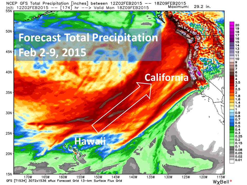
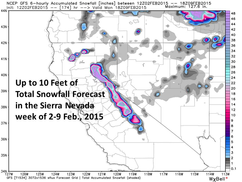
In the next week a series of vigorous Pacific storms fueled partly by the current weak El Nino conditions will bring phenomenal amounts of rain and snow to Northern California: over 2 feet of rain and up to 10 feet of snow in the higher elevations.

After a record dry month in San Francisco, the precipitation is much needed in order to recharge the state’s reservoirs, most of which are still well below their seasonal normal levels.

Here’s the Hawaii-to-California “atmospheric river” that is forecast to set up in the next week, typical of El Nino conditions (forecast graphics courtesy of Weatherbell.com, click to enlarge):

GFS-7-day-precip-fcst-feb02-09-2015-W-Coast

As can be seen, even the Bay area can expect 5+ inches of rain. The snowfall portion of the precipitation will be in the Sierra Nevada, with up to 10 feet of new snow forecast:

GFS-7-day-snow-fcst-feb02-09-2015-NoCal

Most of the heavy precipitation, except for extreme N. California, won’t begin until Thursday of this week.

The “Historic” Blizzard of 2015 Ranked #41

February 1st, 2015

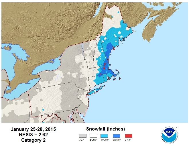
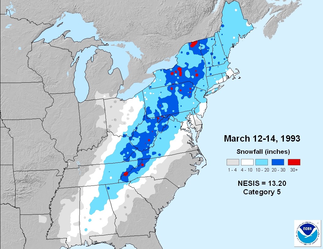
The numbers are in at the National Climate Data Center, and out of the top 55 snowstorms impacting the major population centers of the Northeast U.S., the January 2015 blizzard that blasted Boston ranked #41, or a weak “Category 2”.

Here’s the storm total snowfall map:

NESIS-20150125-20150128-2.62

By comparison, here’s the snowfall total map for the #1 storm, which occurred in mid-March 1993, a Cat 5 storm….note the map is zoomed out to encompass the amazingly large geographic extent of the heavy snowfall in that storm:

NESIS-19930312-19930314-13.20

The ranking is based upon societal impacts, so if the worst storm on Earth in the last 10,000 years hit where no one lived, it would not even rank.

So, the NESIS scale for Northeast snowstorms isn’t well suited for talking about climate change. It’s not clear that more snowstorms in recent decades aren’t just from a slight shift in the storm track bringing Northwest Atlantic winter storms (of which there are many…Greenland routinely gets clobbered) closer to New England.