There will be many comments from others, I’m sure, but these are my initial thoughts on the 12 major findings from the latest National Climate Assessment, which proports to tell us how the global climate change anticipated by the IPCC on a global basis will impact us here at home.
The report findings are in bold and italics. My comments follow each finding.
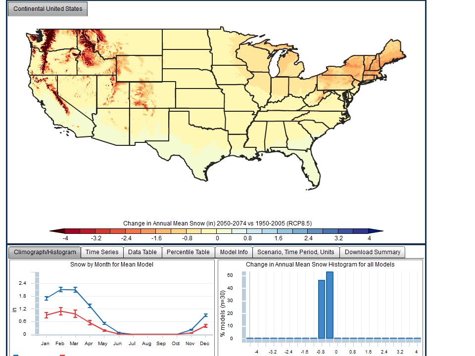
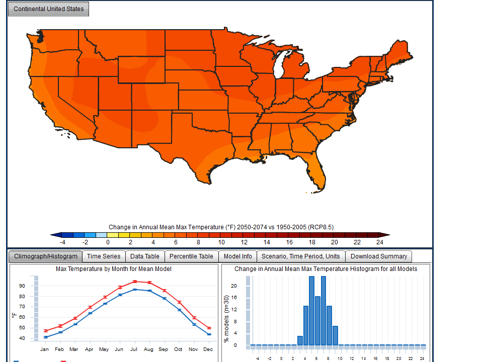
1. Global climate is changing and this is apparent across the United States in a wide range of observations. The global warming of the past 50 years is primarily due to human activities, predominantly the burning of fossil fuels. Many independent lines of evidence confirm that human activities are affecting climate in unprecedented ways. U.S. average temperature has increased by 1.3�F to 1.9�F since record keeping began in 1895; most of this increase has occurred since about 1970. The most recent decade was the warmest on record. Because human-induced warming is superimposed on a naturally varying climate, rising temperatures are not evenly distributed across the country or over time.
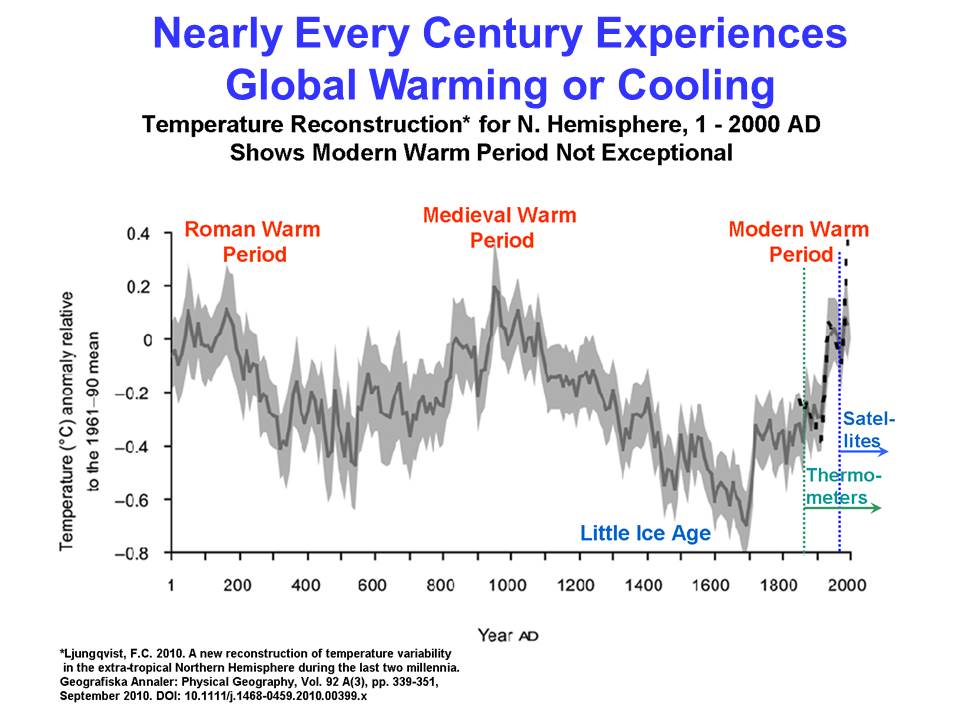
Yes, it has likely warmed, but by an amount which is unknown due to increasing warm biases in thermometer siting, which cannot be removed through �homogenization� adjustments. But there is no way to know whether �The global warming of the past 50 years is primarily due to human activities��, because there is no fingerprint of human-caused versus naturally-caused climate change. To claim the changes are �unprecedented� cannot be demonstrated with reliable data, and are contradicted by some published paleoclimate data which suggests most centuries experience substantial warming or cooling.
2. Some extreme weather and climate events have increased in recent decades, and new and stronger evidence confirms that some of these increases are related to human activities. Changes in extreme weather events are the primary way that most people experience climate change. Human-induced climate change has already increased the number and strength of some of these extreme events. Over the last 50 years, much of the United States has seen an increase in prolonged periods of excessively high temperatures, more heavy downpours, and in some regions, more severe droughts.
There is little or no evidence of increases in severe weather events, except possibly in heavy rainfall events, which would be consistent with modest warming. The statement panders to the publics� focus on the latest severe weather, and limited memory of even worse events of the past.
3. Human-induced climate change is projected to continue, and it will accelerate significantly if global emissions of heat-trapping gases continue to increase. Heat-trapping gases already in the atmosphere have committed us to a hotter future with more climate-related impacts over the next few decades. The magnitude of climate change beyond the next few decades depends primarily on the amount of heat-trapping gases that human activities emit globally, now and in the future.
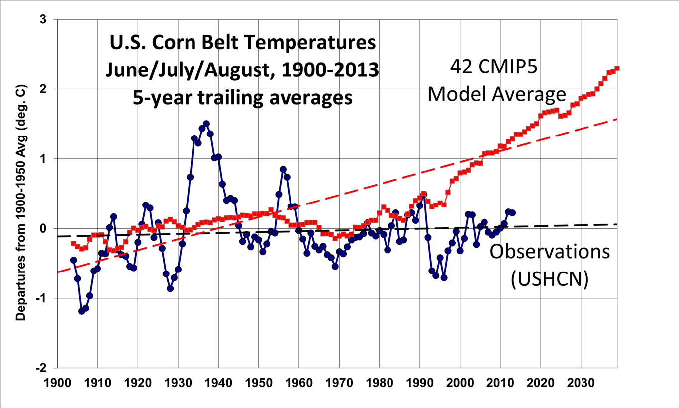
This is a predictive statement based upon climate models which have not even been able to hindcast past global temperatures, let alone forecast changes with any level of accuracy.
4. Impacts related to climate change are already evident in many sectors and are expected to become increasingly disruptive across the nation throughout this century and beyond. Climate change is already affecting societies and the natural world. Climate change interacts with other environmental and societal factors in ways that can either moderate or intensify these impacts. The types and magnitudes of impacts vary across the nation and through time. Children, the elderly, the sick, and the poor are especially vulnerable. There is mounting evidence that harm to the nation will increase substantially in the future unless global emissions of heat-trapping gases are greatly reduced.
To the extent climate has changed regionally, there is no way to know how much has been due to human activities. In fact, it might well be human-induced changes have reduced the negative impact of natural changes � there is simply no way to know. You see, those scientists who study the natural world cannot bring themselves to consider the possibility than some human impacts are actually positive. Even if the human-caused impacts are a net negative, they are far outweighed by the benefits to society (especially the poor) of access to abundant, affordable energy. Besides, for the next few decades, there is nothing substantial we can do about the problem, unless killing off a large portion of humanity, and making the rest miserable, is on the table.
5. Climate change threatens human health and well-being in many ways, including through more extreme weather events and wildfire, decreased air quality, and diseases transmitted by insects, food, and water. Climate change is increasing the risks of heat stress, respiratory stress from poor air quality, and the spread of waterborne diseases. Extreme weather events often lead to fatalities and a variety of health impacts on vulnerable populations, including impacts on mental health, such as anxiety and post-traumatic stress disorder. Large-scale changes in the environment due to climate change and extreme weather events are increasing the risk of the emergence or reemergence of health threats that are currently uncommon in the United States, such as dengue fever.
Most of this is just simply made up, and ignores the positive benefits of access to affordable energy which far outweigh the negatives. If there has been an increase in anxiety and PTSD, it isn�t from severe weather events�it�s from the relentless fear mongering by politicians and the news media.
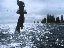
6. Infrastructure is being damaged by sea level rise, heavy downpours, and extreme heat; damages are projected to increase with continued climate change. Sea level rise, storm surge, and heavy downpours, in combination with the pattern of continued development in coastal areas, are increasing damage to U.S. infrastructure including roads, buildings, and industrial facilities, and are also increasing risks to ports and coastal military installations. Flooding along rivers, lakes, and in cities following heavy downpours, prolonged rains, and rapid melting of snowpack is exceeding the limits of flood protection infrastructure designed for historical conditions. Extreme heat is damaging transportation infrastructure such as roads, rail lines, and airport runways.
Sea level rise (which was occurring before we started emitting carbon dioxide in substantial amounts) is a very slow process, which would have to be accommodated for anyway. And the weaker global warming turns out to be, the slower sea level rise will be. Infrastructure damage occurs anyway, and is often due to weather events which exceed the design limits. You don�t engineer roads and buildings and seawalls and levees to handle any possible scenario�it would be too expensive. A large part of our flooding problems are due to the replacement of natural ground with paved surfaces, which enhances runoff into rivers. This has nothing to do with climate change.
7. Water quality and water supply reliability are jeopardized by climate change in a variety of ways that affect ecosystems and livelihoods. Surface and groundwater supplies in some regions are already stressed by increasing demand for water as well as declining runoff and groundwater recharge. In some regions, particularly the southern part of the country and the Caribbean and Pacific Islands, climate change is increasing the likelihood of water shortages and competition for water among its many uses. Water quality is diminishing in many areas, particularly due to increasing sediment and contaminant concentrations after heavy downpours.
This is largely a non sequitur. The problems described exist even without human-caused climate change�to the extent that substantial human influences exist.
8. Climate disruptions to agriculture have been increasing and are projected to become more severe over this century. Some areas are already experiencing climate-related disruptions, particularly due to extreme weather events. While some U.S. regions and some types of agricultural production will be relatively resilient to climate change over the next 25 years or so, others will increasingly suffer from stresses due to extreme heat, drought, disease, and heavy downpours. From mid-century on, climate change is projected to have more negative impacts on crops and livestock across the country � a trend that could diminish the security of our food supply.
I work with the people involved in tracking and long-term prediction of agricultural yields, both domestically and internationally. They see no sign of climate change impacts on agricultural yields. There are always natural fluctuations, but if there is any negative human-induced impact, it is swamped by the increasing yields due to improved agricultural practices, seed varieties, and very likely CO2 fertilization.
9. Climate change poses particular threats to Indigenous Peoples� health, well-being, and ways of life. Chronic stresses such as extreme poverty are being exacerbated by climate change impacts such as reduced access to traditional foods, decreased water quality, and increasing exposure to health and safety hazards. In parts of Alaska, Louisiana, the Pacific Islands, and other coastal locations, climate change impacts (through erosion and inundation) are so severe that some communities are already relocating from historical homelands to which their traditions and cultural identities are tied. Particularly in Alaska, the rapid pace of temperature rise, ice and snow melt, and permafrost thaw are significantly affecting critical infrastructure and traditional livelihoods.
O..M..G. So let�s help poor people by increasing the cost of everything by making the energy on which everything depends even more expensive? The people who write this drivel are so clueless they should not be allowed to influence the decision making process.
10. Ecosystems and the benefits they provide to society are being affected by climate change. The capacity of ecosystems to buffer the impacts of extreme events like fires, floods, and severe storms is being overwhelmed. Climate change impacts on biodiversity are already being observed in alteration of the timing of critical biological events such as spring bud burst and substantial range shifts of many species. In the longer term, there is an increased risk of species extinction. These changes have social, cultural, and economic effects. Events such as droughts, floods, wildfires, and pest outbreaks associated with climate change (for example, bark beetles in the West) are already disrupting ecosystems. These changes limit the capacity of ecosystems, such as forests, barrier beaches, and wetlands, to continue to play important roles in reducing the impacts of these extreme events on infrastructure, human communities, and other valued resources.
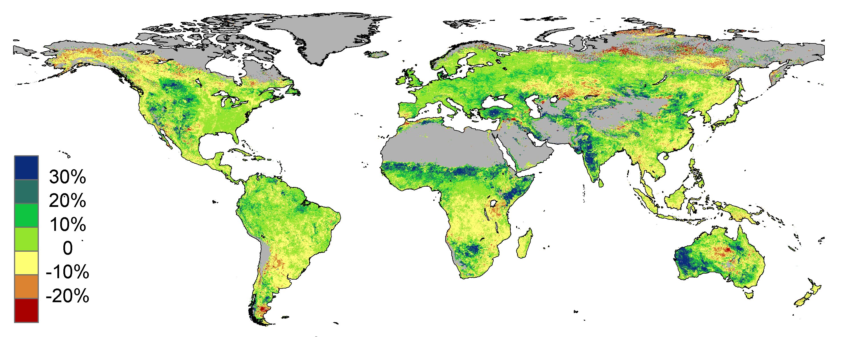
Modest warming and more CO2 available to the biosphere is already having positive impacts, such as the recent greening of the planet. Trying to turn the most obvious positive outcomes into negatives leads to logical contortions which would be funny if they weren�t so serious. Nature changes anyway, folks, as evidenced by glaciers in Europe and North America receding and uncovering ancient tree stumps. Ecosystems are being �overwhelmed�? I don�t think so. Ecosystems are not static.
11. Ocean waters are becoming warmer and more acidic, broadly affecting ocean circulation, chemistry, ecosystems, and marine life. More acidic waters inhibit the formation of shells, skeletons, and coral reefs. Warmer waters harm coral reefs and alter the distribution, abundance, and productivity of many marine species. The rising temperature and changing chemistry of ocean water combine with other stresses, such as overfishing and coastal and marine pollution, to alter marine-based food production and harm fishing communities.
There is increasing evidence that ocean acidification has been greatly overblown. I�m not an expert, but from what I�ve read lately, more realistic lab experiments with adding CO2 to sea water shows that the natural buffering capacity of sea water limits pH changes, and the increasing CO2 is actually good for life in the ocean….just as it is on land (because CO2 is also necessary for the start of the food chain in the ocean). I think the jury is still out on this issue�but, of course, we can�t expect government reports, which are written to facilitate desired policy changes, to provide balance on such things.
12. Planning for adaptation (to address and prepare for impacts) and mitigation (to reduce future climate change, for example by cutting emissions) is becoming more widespread, but current implementation efforts are insufficient to avoid increasingly negative social, environmental, and economic consequences. Actions to reduce emissions, increase carbon uptake, adapt to a changing climate, and increase resilience to impacts that are unavoidable can improve public health, economic development, ecosystem protection, and quality of life.
Translation: We need more government regulation and taxation.
THE BOTTOM LINE:
Follow the money, folks. This glitzy, 840-page report took a lot of your tax dollars to generate, and involved only those �experts� who are willing to play the game. It is difficult to answer in its entirety because government has billions of dollars to invest in this, while most of us who try to bring some sanity to the issue must do it in our spare time, because we aren’t paid to do it. It is nowhere near balanced regarding science, costs-versus-benefits, or implied policy outcomes. Like the previous two National Assessment reports, it takes global climate models which cannot even hindcast what has happened before, which over-forecast global average warming, which are known to have essentially zero skill for regional (e.g. U.S.) predictions, and uses them anyway to instill fear into the masses, so that we might be led to safety by politicians.
Caveat emptor.
(Oh, and if you are tempted to say, “What about all the Big Oil money involved in our need for energy?” Well, that money was willingly given to Big Oil by all of us for a useful product that makes our lives better. Government money is taken from you (I’m not anti-taxation, just pointing out a distinction) that they then use to perpetuate the perceived need for more government control. If “Big Oil” could make a profit by becoming “Big Solar”, or “Big Wind”, they would.)

 Home/Blog
![26-year trends in 37 GHz [V-H] (deg. C per year) for the period 1987-2013.](https://www.drroyspencer.com/wp-content/uploads/trend_big.jpg)
