Steve Goddard recently posted some results from his analysis of the official U.S. surface temperatures (USHCN, from NOAA) suggesting spurious warming occurring around 1998. I also showed evidence of this back in 2012.
Steve’s post reminded me that it’s been over a year since I’ve updated the U.S.-average Integrated Surface Hourly (ISH) temperature data, using my Population Density Adjusted Temperature (PDAT) algorithm that corrects for changing urban heat island (UHI) effects. This is still an unpublished method, and so should be considered more of a sanity check on the official NOAA USHCN product. But it does support Steve’s contention that there’s something funny going on in the USHCN data.
One of the big differences between my ISH PDAT dataset and the official NOAA products is that mine is based upon about 270 stations which monitor hourly temperatures, from which I compute a daily average temperature from the observations at 00, 06, 12, and 18 UTC. This avoids time-of-observation problems associated with computing daily averages from maximum and minimum temperatures, as is done in the USHCN dataset.
Secondly, my dataset only starts in 1973 because that’s the first year with reasonably complete coverage of the U.S. with the hourly observation sites (not the cooperative observer sites which dominate the USHCN dataset which are more numerous but report daily max and min temperatures).
Thirdly, my adjustment for UHI effects is more straightforward than the NOAA homogenization procedure, which I consider rather “opaque”. I believe the NOAA methodology is prone to warming rural sites to match urban sites, rather than cooling the urban sites to match the rural sites. I can’t prove this because, as I said, the homogenization methodology is, well, opaque. In the U.S., my population density adjustment ends up subtracting off an average of about 0.1 deg. C/decade from the temperature trends, but that varies for each station depending upon the change in population density over time. A good place to start for a description of the population density adjustment to temperatures is here. (I now use a constant population density vs. temperature curve for all areas except the Pacific Northwest and the southwest U.S., which show no obvious average warming effects with population density.)
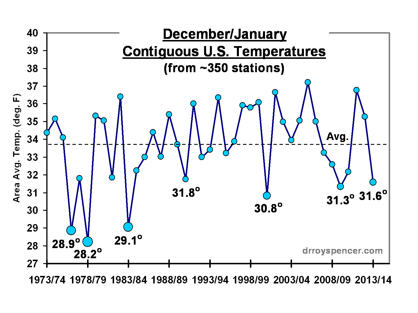
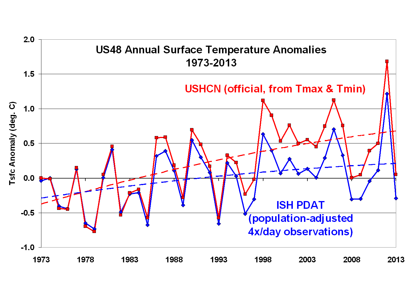
The yearly temperature anomalies for 1973-2013 show that, for the contiguous 48 states, the USHCN Tmax+Tmin observations indicate considerably more warming than the 4x/day temperature observations adjusted for local population density changes (dashed curve fits are 2nd order polynomials):
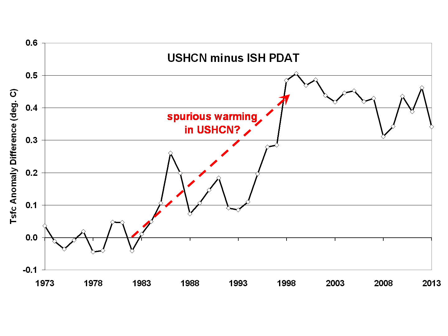
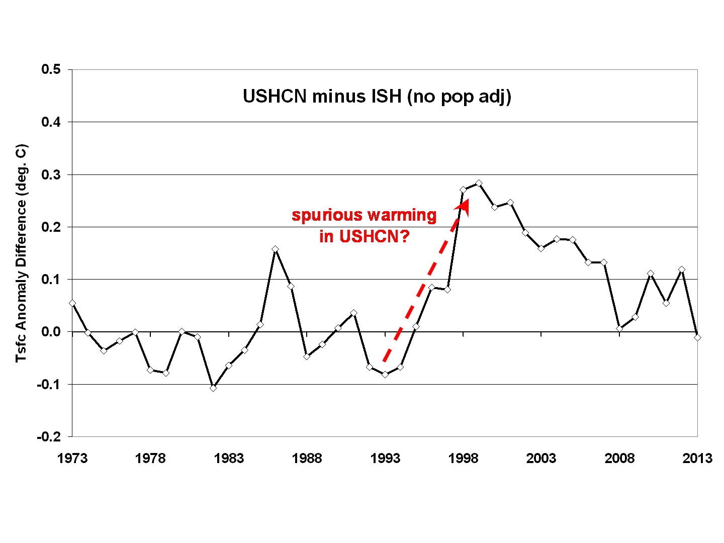
A difference plot of the 2 datasets, as I showed almost 2 years ago, reveals the biggest discrepancy occurs around 1998:
I don’t know all of the sources of these discrepancies, which partly remain even if I *don’t* do a population density adjustment to my dataset:
At some point I need to update the population density adjustment, which originally relied on only 1990 and 2000 census data, which I extrapolated forward and backward in time. Now that NASA/SEDAC has population density estimates up to the present, this would provide some improvement to the adjustments for urban heat island effects.
Clearly, adjustments to surface temperature data are at least as large as the global warming signal being sought. Until a transparent analysis of the USHCN methodology is carried out, and alternative methods and temperature datasets are tested, I can’t bring myself to believe any U.S. government pronouncements regarding record warm temperatures.
ADDENDUM
I see that my previous posts don’t really provide the info needed for those interested in how I’m doing the temperature trend adjustments from changes in population density over time. Here’s the regression relationship I am using:
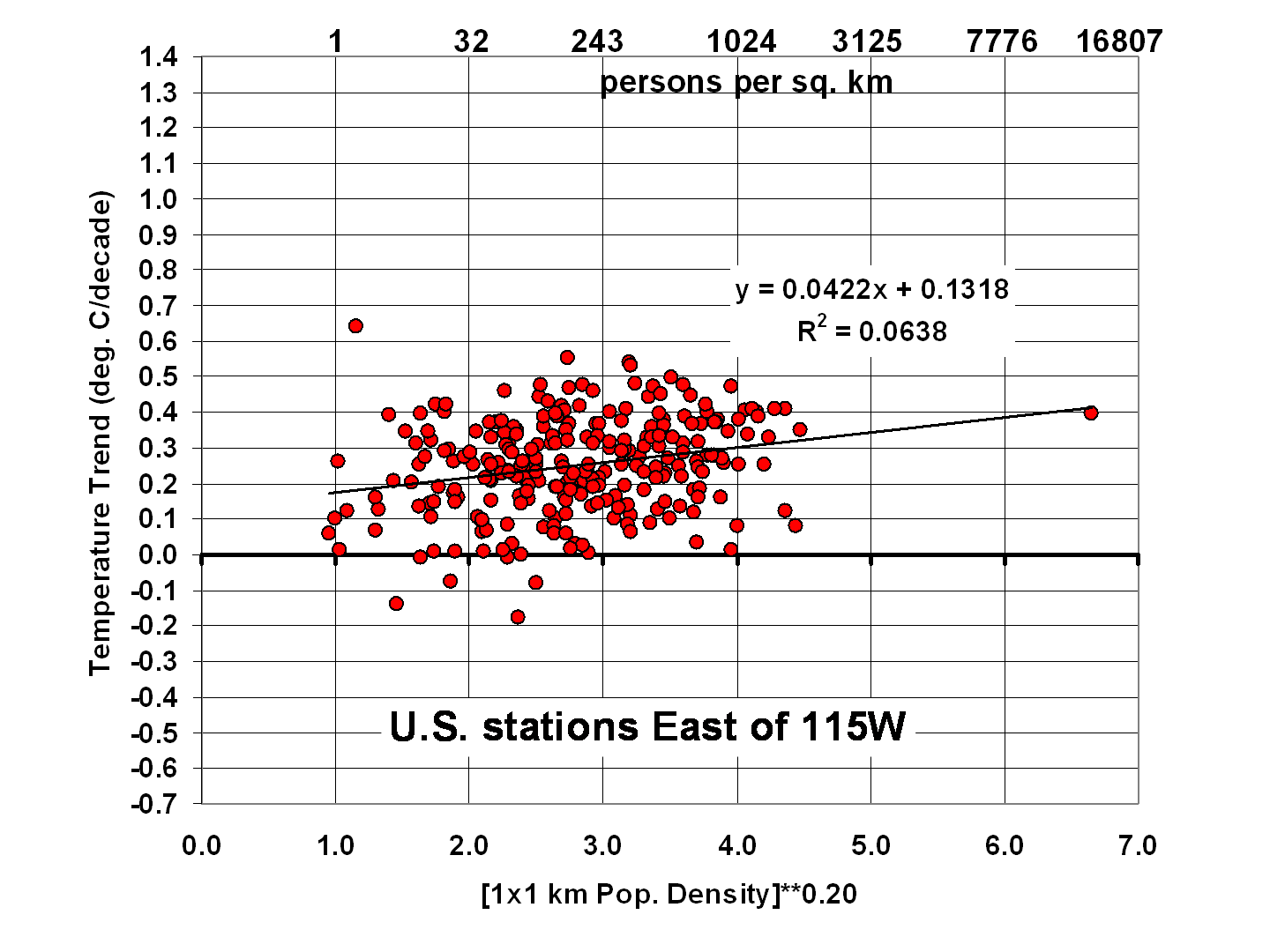
For each station east of 115W, I adjust its temperature anomaly time series using the 0.0422 regression coefficient applied to the change in station location population density (to the 0.2 power) between 1990 and 2000 (extrapolated back to 1973, and forward to 2013). The adjustment starts at zero in 1973, then decreases the trend linearly with time if the population went up, or decreases increases the trend with time if the population went down. The 0.2 power factor is consistent with previous studies that showed the strongest UHI effects occur early in population growth, then level off at higher population densities.

 Home/Blog