(NOTE: minor edits made at 10:00 a.m. CDT, June 15, 2010)
As summer approaches, sea surface temperatures (SSTs) in the Gulf of Mexico increase in response to increased solar insolation (intensity of sunlight). Limiting the SST increase is evaporation, which increases nonlinearly with SST and approximately linearly with increased wind speed. It is important to realize that the primary heat loss mechanism by far for water bodies is evaporation.
By late summer, SSTs in the Gulf peak near 86 or 87 deg. F as these various energy gain and energy loss mechanisms approximately balance one another.
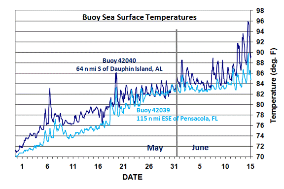
But yesterday, buoy 42040, moored about 64 nautical miles south of Dauphin Island, AL, reported a peak SST of 96 deg. F during very low wind conditions. Since the SST measurement is made about 1 meter below the sea surface, it is likely that even higher temperatures existed right at the surface…possibly in excess of 100 deg. F.
A nice global analysis of the day-night cycle in SSTs was published in 2003 by members of our NASA AMSR-E Science Team, which showed the normal range of this daytime warming, which increases at very low wind speed. But 96 deg. F is truly exceptional, especially for a measurement at 1 meter depth.
The following graph shows the last 45 days of SST measurements from this buoy, as well as buoy 42039 which is situated about 120 nautical miles to the east of buoy 42040.
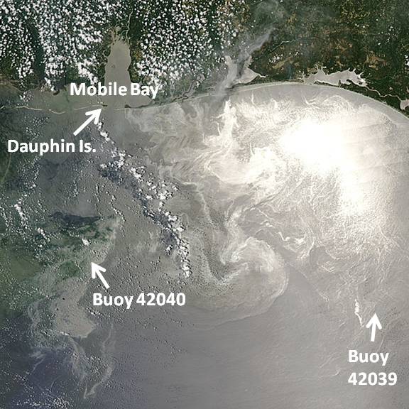
The approximate locations of these buoys are shown in the following MODIS image from the Aqua satellite from 3 days ago (June 12, 2010); the oil slick areas are lighter colored patches, swirls and filaments, and can only be seen on days when the MODIS angle of view is near the point of sun glint (direct reflection of the sun’s image off the surface):
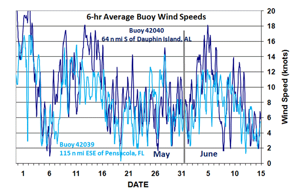
The day-night cycle in SSTs can be clearly seen on most days in the SST plot above, and it becomes stronger at lower wind speeds, as can be seen by comparing those SSTs to the measured wind speeds at these two buoys seen in the next plot:
Since buoy 42040 has been near the most persistent area of oil slick coverage seen by the MODIS instruments on NASA’s Terra and Aqua satellites, I think it is a fair supposition that these very high water temperatures are due to reduced evaporation from the oil film coverage on the sea surface.
OIL SLICK IMPACT ON GULF HURRICANES?
Despite the localized high SSTs, I do not believe that the oil slick will have an enhancement effect on the strength of hurricanes. The depth of water affected is probably pretty shallow, and restricted to areas with persistent oil sheen or slick that has not been disrupted by wind and wave activity.
As any hurricane approaches, higher winds will rapidly break up the oil on the surface, and mix the warmer surface layer with cooler, deeper layers. (Contrary to popular perception, the oil does not make the surface of the ocean darker and thereby absorb more sunlight…the ocean surface is already very dark and absorbs most of the sunlight that falls upon it — over 90%.)
Also, in order for any extra thermal energy to be available for a hurricane to use as fuel, it must be “converted” to more water vapor. Yes, hurricanes are on average strengthened over waters with higher SST, but only to the extent that the overlying atmosphere has its humidity enhanced by those higher SSTs. Evidence of reduced evaporation at buoy 42040 is seen in the following plot which shows the atmospheric temperature and dewpoint, as well as SST, for buoys 42040 (first plot), and 42039 (second plot).
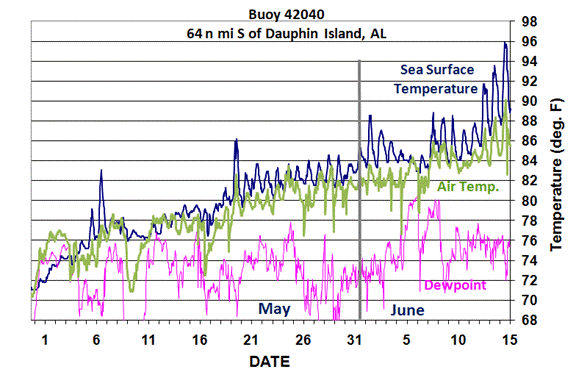
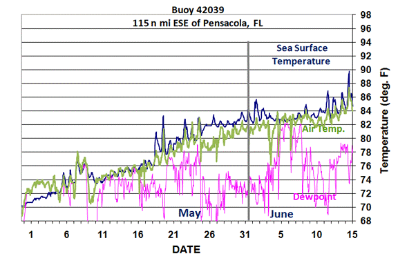
Despite the elevated SSTs at buoy 42040 versus buoy 42039 in recent days, the dewpoint has not risen above what is being measured at buoy 42039 — if anything, it has remained lower.
Nevertheless, I suspect the issue of enhanced sea surface temperatures will be the subject of considerable future research, probably with computer modeling of the impact of such oil slicks on tropical cyclone intensity. I predict the effect will be very small.

 Home/Blog


The climate is quite erratic.