Latest Global Temps
Latest Global Average Tropospheric Temperatures

Since 1979, NOAA satellites have been carrying instruments which measure the natural microwave thermal emissions from oxygen in the atmosphere. The intensity of the signals these microwave radiometers measure at different microwave frequencies is directly proportional to the temperature of different, deep layers of the atmosphere. Every month, John Christy and I update global temperature datasets that represent the piecing together of the temperature data from a total of fifteen instruments flying on different satellites over the years. A discussion of the latest major version update (6.0) of the dataset is located here.
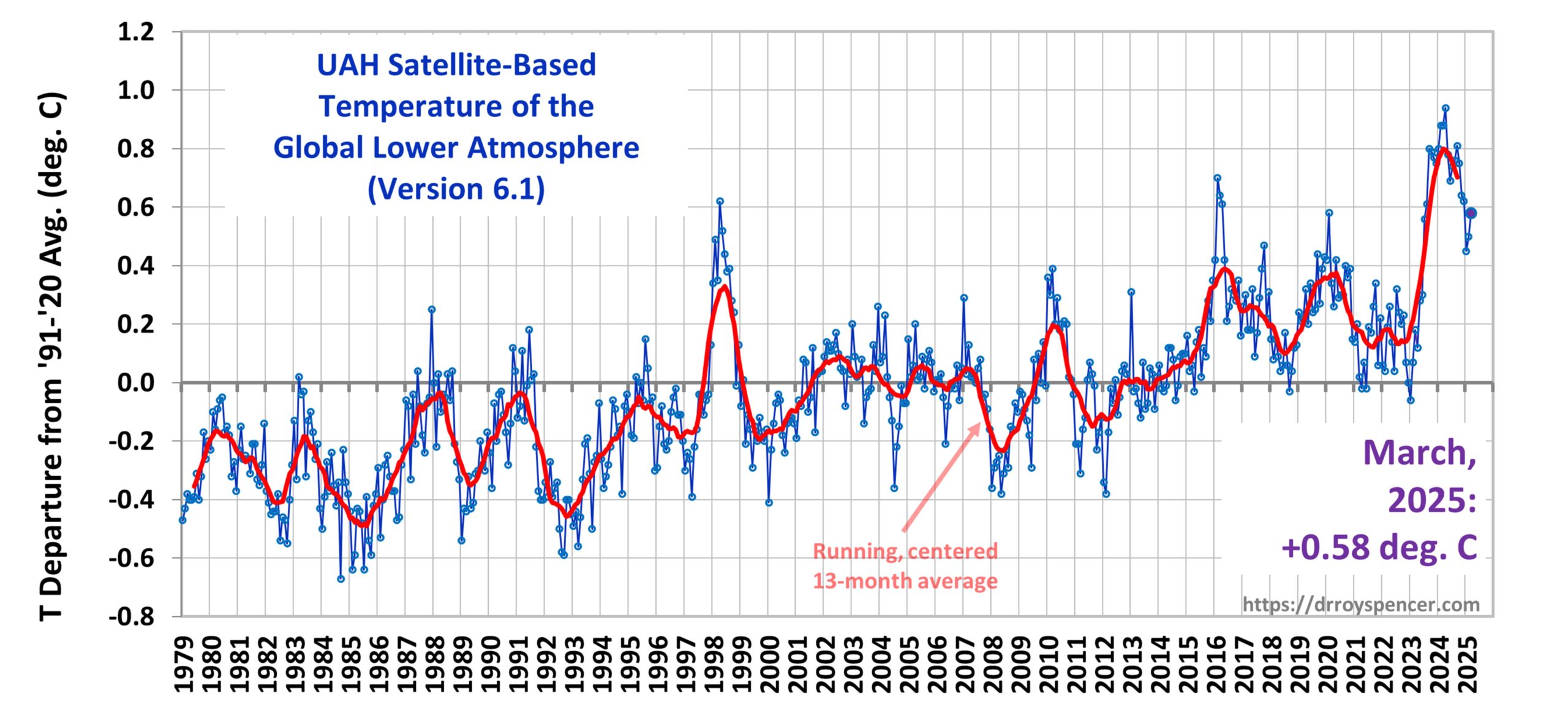
The graph above represents the latest update; updates are usually made within the first week of every month. Contrary to some reports, the satellite measurements are not calibrated in any way with the global surface-based thermometer records of temperature. They instead use their own on-board precision redundant platinum resistance thermometers (PRTs) calibrated to a laboratory reference standard before launch, embedded in high-emissivity targets that are viewed by the radiometer once each scan. The radiometers also view the cosmic background radiation (assumed to be 2.7 Kelvin) once each scan. The Earth-viewing measurements are then interpolated between the cosmic background temperature and the warm calibration target temperature.
The digital data for the above plot, as well as for various sub-regions of the Earth and for three other atmospheric layers, are available at the links below. You can copy and paste the data into a spreadsheet program like Excel to do your own plotting and analysis (in Excel, you might need to use the “Data>Text to Columns” function to get the data separated into columns after pasting):
Lower Troposphere: http://vortex.nsstc.uah.edu/data/msu/v6.1/tlt/uahncdc_lt_6.1.txt
Mid-Troposphere: http://vortex.nsstc.uah.edu/data/msu/v6.1/tmt/uahncdc_mt_6.1.txt
Tropopause: http://vortex.nsstc.uah.edu/data/msu/v6.1/ttp/uahncdc_tp_6.1.txt
Lower Stratosphere: http://vortex.nsstc.uah.edu/data/msu/v6.1/tls/uahncdc_ls_6.1.txt

 Home/Blog


