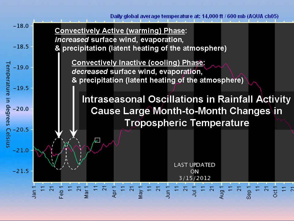
One of the most frequent questions I get pertains to the large amount of variability seen in the daily global-average temperature variations we make available on the Discover website. From Aqua AMSU ch. 5, these temperatures can undergo wide swings every few weeks, leading to e-mail questions like, Is the satellite broken?
Unusually good examples of these have occurred over the last couple months. In the following plot I took from today, we see January and February of 2012 experiencing two full cycles of temperature variations of about 0.5 deg. C (click for large version):
We have observed this behavior ever since John Christy and I started the satellite-based global temperature monitoring business over 20 years ago.
These temperature swings are mostly the result of variations in rainfall activity. Precipitation systems, which are constantly occurring around the world, release the latent heat of condensation of water vapor which was absorbed during the process of evaporation from the Earth’s surface.
While this process is continuously occurring, there are periods when such activity is somewhat more intense or widespread. These events, called Intra-Seasonal Oscillations (ISOs) are most evident over the tropical Pacific Ocean.
During the convectively active phase of the ISO, there are increased surface winds of up to 1 to 2 knots averaged over the tropical oceans, which causes faster surface evaporation, more water vapor in the troposphere, and more convective rainfall activity. This above-average release of latent heat exceeds the rate at which the atmosphere emits infrared radiation to space, and so the resulting energy imbalance causes a temperature increase (see the above plot).
During the convectively inactive phase, the opposite happens: a decrease in surface wind, evaporation, rainfall, and temperature, as the atmosphere radiatively cools more rapidly than latent heating can replenish the energy.
(As I keep emphasizing, a temperature change is caused by an imbalance between energy gain and energy loss. You can cause warming either by increasing the rate of energy gain, or by decreasing the rate of energy loss. This is how the “greenhouse effect” works, by reducing the rate of radiative energy loss by the surface).
There are observed cloud and radiation budget changes associated with ISOs, as described in our 2007 paper which analyzed the average behavior of the ISO over a 6 year period (see Figs. 1, 2, and 3 in that paper). The main mode of ISO activity is called the Madden-Julian Oscillation.
How Can Rainfall Cause Warming?
I will admit, even as a fresh PhD researcher, the idea that rainfall causes heating seemed counter-intuitive. This is because we are used to the cooling effect of rain when it falls to the surface, which is where we live. But high up in the atmosphere where the rain forms, huge amounts of heat are given up in the process. Just as water evaporating from your skin feels cool, that extra heat is given up when the water condenses back into liquid.
The most vivid example of this process is the warm core of a hurricane, which is heated by the rainfall occurring around the hurricane eye. What actually happens is that the latent heat release within clouds causes localized warming which is almost immediately “relieved” by ascending motion (convective updrafts, which frequent flyers are familiar with).
Because rising air cools, there is little net temperature change in the ascending parcels of air…but all of that rising air also forces air outside of the cloud systems to sink, causing “subsidence warming”. That is where most of the actual temperature increase takes place. The hurricane eye is the most extreme example of this process, where subsiding air gets concentrated in a relatively small region and the temperature can rise many degrees. More commonly though (such as with the ISO phenomenon), the subsidence warming gets spread over hundreds or thousands of km of atmosphere, and the temperature rise is only a fraction of a degree.

 Home/Blog


