While the vast majority of our monthly global temperature updates are pretty routine, September 2019 is proving to be a unique exception. The bottom line is that there is nothing wrong with the UAH temperatures we originally reported. But what I discovered about last month is pretty unusual.
It all started when our global lower tropospheric (LT) temperature came in at an unexpectedly high +0.61 deg. C above the 1981-2010 average. I say “unexpected” because, as WeatherBell’s Joe Bastardi has pointed out, the global average surface temperature from NOAA’s CFS model had been running about 0.3 C above normal, and our numbers are usually not that different from that model product.
[By way of review, the three basic layers we compute average temperatures from the satellites are, in increasing altitude, the mid-troposphere (MT), tropopause region (TP), and lower stratosphere (LS). From these three deep layer temperatures, we compute the lower tropospheric (LT) product using a linear combination of the three main channels, LT = 1.548MT – 0.538TP +0.01LS.]
Yesterday, John Christy noticed that the Southern Hemisphere was unusually warm in our lower stratosphere (LS) temperature product, while the Northern Hemisphere was unusually cool. This led me to look at the tropical results for our mid-troposphere (MT) and ‘tropopause’ (TP) products, which in the tropics usually track each other. A scatterplot of them revealed September 2019 to be a clear outlier, that is, the TP temperature anomaly was too cool for the MT temperature anomaly.
So, John put a notice on his monthly global temperature update report, and I added a notice to the top of my monthly blog post, that we suspected maybe one of the two satellites we are currently using (NOAA-19 and Metop-B) had problems.
As it turns out, there were no problems with the data. Just an unusual regional weather event that produced an unusual global response.
Blame it on Antarctica
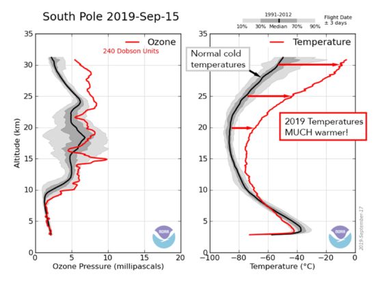
Some of you might have seen news reports several weeks ago that a strong stratospheric warming (SSW) event was expected to form over Antarctica, potentially impacting weather in Australia. These SSW events are more frequent over the Arctic, and occur in winter when (put very simply) winds in the stratosphere flow inward and force air within the cold circumpolar vortex to sink (that’s called subsidence). Since the stratosphere is statically stable (its temperature lapse rate is nearly isothermal), any sinking leads to a strong temperature increase. CIRES in Colorado has provided a nice description of the current SSW event, from which I copied this graphic showing the vertical profile of temperature normally (black like) compared to that for September (red line).

By mass continuity, the air required for this large-scale subsidence must come from lower latitudes, and similarly, all sinking air over Antarctica must be matched by an equal mass of rising air, with temperatures falling. This is part of what is called the global Brewer-Dobson circulation in the stratosphere. (Note that because all of this occurs in a stable environment, it is not ‘convection’, but must be forced by dynamical processes).
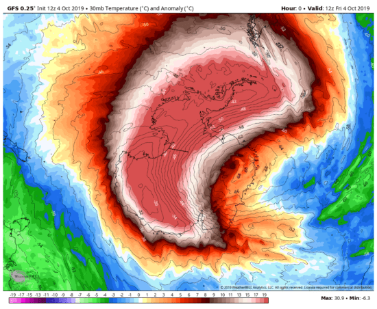
As can be seen in this GFS model temperature field for today at the 30 mb level (about 22 km altitude) the SSW is still in play over Antarctica.

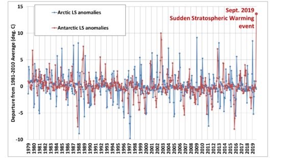
The following plot of both Arctic and Antarctic UAH LS temperature anomalies shows just how strong the September SSW event was, with a +13.7 deg. C anomaly averaged over the area poleward of 60 deg. S latitude. The LS product covers the layer from about 15 to 20 km altitude.

As mentioned above, when one of these warm events happens, there is cooling that occurs from the rising air at the same altitudes, even very far away. Because the Brewer-Dobson circulation connects the tropical stratosphere to the mid-latitudes and the poles, a change in one region is mirrored with opposite changes elsewhere.
As evidence of this, if I compute the month-to-month changes in lower stratospheric temperatures for a few different regions, I find the following correlations between regions (January 1979 through September 2019). These negative correlations are evidence of this see-saw effect in stratospheric temperature between different latitudes (and even hemispheres).
Tropics vs. Extratropics: -0.78
Arctic vs. S. Hemisphere: -0.70
Antarctic vs. N. Hemisphere: -0.50
N. Hemis. vs. S. Hemis.: -0.75
Because of the intense stratospheric warming over Antarctica, it caused an unusually large difference in the NH and SH anomalies, which raised a red flag for John Christy.
Next I can show that the SSW event extended to lower altitudes, influencing the TP channel which we use to compute the LT product. This is important because sinking and warming at the altitudes of the TP product (roughly 8-14 km altitude) can cause cooling at those same altitudes very far away. This appears to be why I noticed the tropics having the lowest-ever TP temperature anomaly for the MT anomaly in September, which raised a red flag for me.
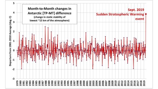
In this plot of the difference between those two channels [TP-MT] over the Antarctic, we again see that September 2019 was a clear outlier.

Conceptually, that plot shows that the SSW subsidence warming extends down into altitudes normally considered to be the upper troposphere (consistent with the CIRES plot above). I am assuming that this led to unusual cooling in the tropical upper troposphere, leading to what I thought was anomalous data. It was indeed anomalous, but the reason wasn’t an instrument problem, it was from Mother Nature.
Finally, Danny Braswell ran our software, leaving out either NOAA-19 or Metop-B, to see if there was an unusual difference between the two satellites we combine together. The global LT anomaly using only NOAA-19 was +0.63 deg. C, while that using only Metop-B was +0.60 deg. C, which is pretty close. This essentially rules out an instrument problem for the unusually warm LT value in September, 2019.

 Home/Blog


石器私服一条龙制作www仙境1u开区一条龙服务端ROһ<a href="http://www.81uv.com客服咨询w.81uv.com-ͷѯQQ915515538-Email:915515538@qq.com